Description:
Sheet size 10 1/4 inches x 14 inches, fully margined beyond the plate mark, except the bottom edge, which is trimmed to the plate mark, a few tiny worm holes toward the right margin and lower left. The drawing has been attributed to Richard Brookshaw and the German engraver Johann Elias Haid made his own mezzotint from the same drawing.
Africa, Manuscript Map, 1830 (Society of Friends) by Phebe Varney - 1830: Phebe Varney, 1830, Dover, Duchess County (New York)
by Phebe Varney

Africa, Manuscript Map, 1830 (Society of Friends): Phebe Varney, 1830, Dover, Duchess County (New York)
by Phebe Varney
- Used
Map Details:
dimensions: 18 ¾" x 23 1/8" within neat lines, 19 ½" x 23 ½" overall
condition: as found, generally good, 6" vertical tear, some edge wear, complete
Map Description:This hand drawn map is signed "Phebe Varney, 1830. Dover Duchess County" on the front. The title of the map is "Africa". The map is hand drawn on thick paper with colored inks and possibly a fine brush. The thickness and opacity of the paper would not have permitted easy tracing and therefore it is most likely the author of the map drew it freehand, perhaps using a grid system (or longitude and latitude lines) to scale up or down a published map or set of maps of Africa. The map appears to be unique.
Phebe Varney and her family belonged to the Society of Friends in New York. She was born June 16, 1810 in Nine Partners, Duchess County, New York to Jedediah and Mary (Hoag) Varney according to Nine Partners Records. Tragically her mother died in childbirth two years later. The family removed to Oblong, New York in 1824 when Phebe was 14 years old and of school age. By 1830, the date of this map, Phebe would have been 20 years old. To supplement my research of records of the Society of Friends, I engaged a genealogist, Mr. J.E. Hazard, a specialist who comes recommended by Swarthmore College for searching Swarthmore's archive of Quaker records on site. His report provided no additional biographical information about Phebe Varney beyond her birth date and removal date, and no mention of her in school records.
My initial surmise was that Phebe Varney was either an older student or a teacher in the vicinity of Nine Partners or Oblong, New York when she drew this map. One possible school is the Nine Partners Boarding School, founded by the Quakers in 1796 as the first day and boarding school in Nine Partners (Village of Millbrook), New York that admitted students until 1863. Phebe Varney lived in this area and was of school age at this time. Nine Partners Boarding School was succeeded by the Friends' Oakwood School of Poughkeepsie, New York, and this school is in operation today. I was advised by staff of the Oakwood School that it has no records of Phebe Varney. School records identify a teacher named Mary Hoag in 1840. Ann Varney is listed in school records as well according to the school archivist. I was advised by the Oakwood School that one manuscript map does exist in the school archives, not of Africa and not signed by Phebe Varney.
Phebe Varney's hand drawn map, rather large for a "school girl map", is dense with detail and may be a compilation of published maps, including those in Nine Partners Boarding School head teacher and former student James Willetts' Compendius System of Geography and his accompanying atlas that were in a 2nd edition by 1822, published by Willetts in Poughkeepsie ("Africa" map not available for inspection). 1/ Other published map sources for Phebe Varney could include Scottish and American maps and missionary reports from travels in Africa. Her map graphically resembles an engraved map titled "Africa" in John Thomson's A New General Atlas published in Edinburgh from 1817 to c. 1821. Phebe Varney's map bears some resemblance to Carey's 1805"A New Map of Africa". Neither published map is an exact match. The Varney map notes the "Meridian of London" while the Thomson maps reference the "Meridian of Greenwich". Henry Tanner's 1833 map "Africa" is also similar but not identical to Phebe's map as to place names. Mathew Carey's 1820 map "Africa", published in Philadelphia is also a possible model for elements of Phebe Varney's hand drawn map. John Melish's 1820 map "Africa", published in Philadelphia bears a strong graphic resemblance to Phebe Varney's map with water shown as wavy lines, and substantively in terms of the choice and spelling of place names.
Why a map of Africa? The American Quakers were among America's first anti-slavery advocates. Quakers sailed to Africa, and certain Nantucket Whalers established a community in Cape Town, South Africa. 2/ British Quakers were already in South Africa in the 1830's.3/ Phebe Varney's large, detailed map may have been for a geography lesson, or related to anti-slavery advocacy and education or for a reason we cannot know.
Phebe Varney's map presents geography and topographical features such as streams, ponds, rivers, deserts, mountains and mountain ranges of Africa, as well as political subdivisions and settled areas. The "Mountains of the Moon" are shown in great pictorial detail. Political borders are shown with color, dots and hatch marks. The "Supposed Course of the Niger" river is represented. Another area of the map is labeled "Vast Unexplored Regions." Her map shows two Christian cross symbols in the region of the Colony of the Cape in South Africa, at the Christian missions of Bethesda and Bethelsdorp. Graphic citations on a map in 1830 of these missions are infrequent. In Arabia, the southern coast is labeled Ab. Happy, a possible reference to Yemen as described by Ptolemy and later others as "Happy Arabia", first named thus by the Romans as a fertile area. These unusual map features of religious history and 19th century missionary work in Africa (the Bethelsdorp mission was known for protecting Africans from local slavery) support the thesis that Phebe Varney brought her Quaker values to this task. The notation "no fresh water" on Africa's west coast just above the Tropic of Capricorn may suggest commentary from missionary journals.
All of these pictorial and written elements make Phebe Varney's map unique substantively, and not just as a function of it being a manuscript map. Her map expresses an understanding of how Africa was described by writers historically as well as of how her contemporary cartographers and early travelers portrayed the continent. The map speaks to us as a work of art, of history and perhaps also of quiet religious conviction that the people of this continent deserved to be known and understood as equals.
-
Seller
Original Antique Maps
 (US)
(US)
- Book Condition Used
- Quantity Available 1
- Publisher manuscript
- Place of Publication Duchess County, New York
- Date Published 1830
- Keywords Society of Friends, American Manuscript Map, Map of Africa, Abolition, Society of Friends

Mezzotint portrait: John Paul Jones, Commander of a Squadron in the Service of The Thirteen United States of North America, 1779
by Jones, John Paul (subject)
- Used
- Condition
- Used
- Binding
- Unknown
- Quantity Available
- 1
- Seller
-
CHESTER, Connecticut, United States
- Item Price
-
A$4,740.30
Show Details
Item Price
A$4,740.30
More Photos
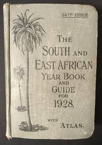
The South and East African Year Book Guide. With Atlas and Diagrams. 34th Issue owned by A. Jessop: Union-Castle Atlas pp. 2-64 with color maps, single and double page, George Philips & Son, Geographical Institute, London
by Edited Annually By A. Samler Brown, F.R.M.S. & G. Gordon Brown, F.R.G.S.
- Used
- Hardcover
- Signed
- Condition
- Used
- Edition
- 34th
- Binding
- Hardcover
- Quantity Available
- 1
- Seller
-
FRAMINGHAM, Massachusetts, United States
- Item Price
-
A$434.53
Show Details
Description:
Contents and Condition:Union-Castle Atlas pp. 2-64 with color maps, single and double page, George Philips & Son, Geographical Institute, London"Advertisements South Africa, Capetown with East Africa Route", pp. 1-129.
dimensions: 7 3/8" x 5 1/2" x 1 5/8"
condition: decorated fabric covers show mild wear, binding tight, front cover attached with weakening at bottom of binding
owner's name in manuscript ink on title page: "A.Jessop Coronado, California, U.S.A"Description:
This densely informative travel guide was owned by A. Jessop of Coronado, California. The A. Jessop who owned this book is most likely a son of Joseph Edward Jessop, an English watchmaker and jewelry store owner who with his wife emigrated from London, England to California, seeking to settle in the San Diego area with their children. The Jessop family established a jewelry store that became multi-generational in the San Diego, California area. In 1901 the Jessop family moved to Coronado, California. In 1907, Mr. Jessop… Read More
Item Price
A$434.53
More Photos
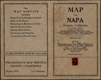
Napa County California. 1914
by Copyright 1914 by Punnett Brothers
- Used
- Condition
- Used
- Quantity Available
- 1
- Seller
-
FRAMINGHAM, Massachusetts, United States
- Item Price
-
A$1,501.10
Show Details
Description:
Map Details and Condition:color lithograph
dimensions: 26 3/4" x 19"
Brown Paper pocket covers with red bookstore label of Neal Stratford & Kerr, San Francisco
condition: professionally flattened and otherwise in as found, very good conditionDescription:
This 1914 map of now popular wine country Napa County, California shows the county in 1914, with early roads, largely undeveloped, vast open land areas, and natural features. The numbered grid system on this map reflects the Public Land Survey System. Large open tracts of land are identified as ranches, such as Rancho Catacoula, or Rancho Las Putas, Rancho LaJota all of which are large swaths of undivided land. Urban grids are shown in the southernmost part of Napa County, and sections of the southernmost sections of Sonoma County and Solano County. The cities of Petaluma, Sonoma, Vallejo and Napa and Benicia show populated urban areas. A corner of Marin County is shown.
C.F. Weber & Co. and the Punnett Brothers published… Read More
Item Price
A$1,501.10

Published by the Milwaukee Sentinel Commemorating Its One Hundredth Anniversary June 27, 1937: Approved by the Wisconsin Conservation Commission, Checked and Approved by Dr. Joseph Schafer, Superintendent of the Historical Society of Wisconsin and Dr. Louise Phelps Kellogg, Senior Research Associate Endorsed by the Wisconsin State Chamber of Commer
by Copyright 1932 by Erwin F. Bahlmann and Artist Nina S. Bahlman
- Used
- Condition
- Used
- Quantity Available
- 1
- Seller
-
FRAMINGHAM, Massachusetts, United States
- Item Price
-
A$1,027.06
Show Details
Description:
Map Details and Condition:color lithograph by Litho in U.S.A.
dimensions: 24" x 28.5 " print, 26 1/4" x 30" sheet size
condition: professionally removed from wood backing and restored, deeply toned paper, some surface damage to paper, repaired vertical tear through sheet, backed with Japanese Mulberry tissue, some chipping at edges Map Description:
This scarce Wisconsin pictorial map was created by the artist Nina S. Bahlman (b1886-___) whose art work other than this map may exist in collections but is not readily identified. The copyright is held by Erwin F. Bahlmann (b.1886-__) a family member or spouse. The Library of Congress cites its copy of this map as Historical Map of Wisconsin and cites a 1995 copyright registration. WorldCat confirms that there is a 1995 reprint of this map. A further note corrects the spelling of the artist's name to read "Bahlmann". The example of the map on offer gives every appearance of being the 1932 edition.
The map was published… Read More
Item Price
A$1,027.06
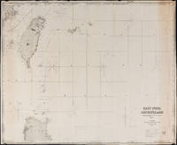
East India Archipelago Chart No. 7 (1878): Formosa
by James Imray and Son
- Used
- Condition
- Used
- Quantity Available
- 1
- Seller
-
FRAMINGHAM, Massachusetts, United States
- Item Price
-
A$1,422.09
Show Details
Description:
Chart Details:black and white engraving, navigation lights marked with red and yellow, blue backed
Blue ink stamp next to title block: "Imray & Son London 1878"
Publisher's original paper label glued to back of chart
condition: as found rolled, top left corner approx. 2" piece missing that includes some of perimeter printed border of chart, overall a clean chart with some spotting on edges, some spotting in vicinity of title block, paper toned along right vertical edge chart, edges overall in good condition, this chart was used to plot several voyages and has manuscript pencil notes with dates
Item Price
A$1,422.09
Mezzotint portrait: John Paul Jones, Commander of a Squadron in the Service of The Thirteen United States of North America, 1779
by Jones, John Paul (subject)
- Used
- Condition
- Used
- Binding
- Unknown
- Quantity Available
- 1
- Seller
-
CHESTER, Connecticut, United States
- Item Price
-
A$4,740.30
Show Details
Description:
Sheet size 10 1/4 inches x 14 inches, fully margined beyond the plate mark, except the bottom edge, which is trimmed to the plate mark, a few tiny worm holes toward the right margin and lower left. The drawing has been attributed to Richard Brookshaw and the German engraver Johann Elias Haid made his own mezzotint from the same drawing.
Item Price
A$4,740.30
More Photos
The South and East African Year Book Guide. With Atlas and Diagrams. 34th Issue owned by A. Jessop: Union-Castle Atlas pp. 2-64 with color maps, single and double page, George Philips & Son, Geographical Institute, London
by Edited Annually By A. Samler Brown, F.R.M.S. & G. Gordon Brown, F.R.G.S.
- Used
- Hardcover
- Signed
- Condition
- Used
- Edition
- 34th
- Binding
- Hardcover
- Quantity Available
- 1
- Seller
-
FRAMINGHAM, Massachusetts, United States
- Item Price
-
A$434.53
Show Details
Description:
Contents and Condition:Union-Castle Atlas pp. 2-64 with color maps, single and double page, George Philips & Son, Geographical Institute, London"Advertisements South Africa, Capetown with East Africa Route", pp. 1-129.
dimensions: 7 3/8" x 5 1/2" x 1 5/8"
condition: decorated fabric covers show mild wear, binding tight, front cover attached with weakening at bottom of binding
owner's name in manuscript ink on title page: "A.Jessop Coronado, California, U.S.A"Description:
This densely informative travel guide was owned by A. Jessop of Coronado, California. The A. Jessop who owned this book is most likely a son of Joseph Edward Jessop, an English watchmaker and jewelry store owner who with his wife emigrated from London, England to California, seeking to settle in the San Diego area with their children. The Jessop family established a jewelry store that became multi-generational in the San Diego, California area. In 1901 the Jessop family moved to Coronado, California. In 1907, Mr. Jessop… Read More
Item Price
A$434.53
More Photos
Napa County California. 1914
by Copyright 1914 by Punnett Brothers
- Used
- Condition
- Used
- Quantity Available
- 1
- Seller
-
FRAMINGHAM, Massachusetts, United States
- Item Price
-
A$1,501.10
Show Details
Description:
Map Details and Condition:color lithograph
dimensions: 26 3/4" x 19"
Brown Paper pocket covers with red bookstore label of Neal Stratford & Kerr, San Francisco
condition: professionally flattened and otherwise in as found, very good conditionDescription:
This 1914 map of now popular wine country Napa County, California shows the county in 1914, with early roads, largely undeveloped, vast open land areas, and natural features. The numbered grid system on this map reflects the Public Land Survey System. Large open tracts of land are identified as ranches, such as Rancho Catacoula, or Rancho Las Putas, Rancho LaJota all of which are large swaths of undivided land. Urban grids are shown in the southernmost part of Napa County, and sections of the southernmost sections of Sonoma County and Solano County. The cities of Petaluma, Sonoma, Vallejo and Napa and Benicia show populated urban areas. A corner of Marin County is shown.
C.F. Weber & Co. and the Punnett Brothers published… Read More
Item Price
A$1,501.10
Published by the Milwaukee Sentinel Commemorating Its One Hundredth Anniversary June 27, 1937: Approved by the Wisconsin Conservation Commission, Checked and Approved by Dr. Joseph Schafer, Superintendent of the Historical Society of Wisconsin and Dr. Louise Phelps Kellogg, Senior Research Associate Endorsed by the Wisconsin State Chamber of Commer
by Copyright 1932 by Erwin F. Bahlmann and Artist Nina S. Bahlman
- Used
- Condition
- Used
- Quantity Available
- 1
- Seller
-
FRAMINGHAM, Massachusetts, United States
- Item Price
-
A$1,027.06
Show Details
Description:
Map Details and Condition:color lithograph by Litho in U.S.A.
dimensions: 24" x 28.5 " print, 26 1/4" x 30" sheet size
condition: professionally removed from wood backing and restored, deeply toned paper, some surface damage to paper, repaired vertical tear through sheet, backed with Japanese Mulberry tissue, some chipping at edges Map Description:
This scarce Wisconsin pictorial map was created by the artist Nina S. Bahlman (b1886-___) whose art work other than this map may exist in collections but is not readily identified. The copyright is held by Erwin F. Bahlmann (b.1886-__) a family member or spouse. The Library of Congress cites its copy of this map as Historical Map of Wisconsin and cites a 1995 copyright registration. WorldCat confirms that there is a 1995 reprint of this map. A further note corrects the spelling of the artist's name to read "Bahlmann". The example of the map on offer gives every appearance of being the 1932 edition.
The map was published… Read More
Item Price
A$1,027.06
East India Archipelago Chart No. 7 (1878): Formosa
by James Imray and Son
- Used
- Condition
- Used
- Quantity Available
- 1
- Seller
-
FRAMINGHAM, Massachusetts, United States
- Item Price
-
A$1,422.09
Show Details
Description:
Chart Details:black and white engraving, navigation lights marked with red and yellow, blue backed
Blue ink stamp next to title block: "Imray & Son London 1878"
Publisher's original paper label glued to back of chart
condition: as found rolled, top left corner approx. 2" piece missing that includes some of perimeter printed border of chart, overall a clean chart with some spotting on edges, some spotting in vicinity of title block, paper toned along right vertical edge chart, edges overall in good condition, this chart was used to plot several voyages and has manuscript pencil notes with dates
Item Price
A$1,422.09

Attempt on Roosevelt Life
by nebraska state journal
- Used
- Condition
- Used
- Quantity Available
- 1
- Seller
-
Lincoln, Nebraska, United States
- Item Price
-
A$15.80
Show Details
Description:
full
Item Price
A$15.80

Cap'n Kid Goes To The South Pole
by Engle, Joanna
- Used
- good
- Paperback
- first
- Condition
- Used - Good
- Jacket Condition
- None Issued
- Edition
- First Edition
- Binding
- Paperback
- ISBN 13
- 9780394856438
- ISBN 10
- 0394856430
- Quantity Available
- 1
- Seller
-
Salem, Oregon, United States
- Item Price
-
A$39.50A$23.70Save A$10.00!
Show Details
Description:
Engle, Joanna. Cap'n Kid Goes To The South Pole. A Seaworld Adventure featuring Shamu, the Killer Whale. RARE. Children's Book. Used. Good, clean Condition. Softcover. Stapled binding. Random House copyright 1983. 5 ½ X 5. ISBN 0394856430. Original cover price $1.25.
Item Price
A$39.50A$23.70
Save A$10.00
!
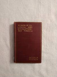
DOLLY MADISON: WOMEN OF COLONIAL AND REVOLUTIONARY TIMES
by Goodwin, Maud Wilder
- Used
- good
- Hardcover
- first
- Condition
- Used - Good
- Edition
- First Edition
- Binding
- Hardcover
- Quantity Available
- 1
- Seller
-
Buffalo, Wyoming, United States
- Item Price
-
A$43.45A$36.94Save A$4.12!
Show Details
Description:
New York: Charles Scribner's Sons, 1886. First Edition . Hardcover. Good. 12mo - over 6¾" - 7¾" tall. Book is in G condition with light rubbing to edges, cocked spine, bumping & fraying to spine ends, pencil marking to FFE, owner's name to title page, a couple of small tears to title page else still a bright and solid copy. SA 6/21
Item Price
A$43.45A$36.94
Save A$4.12
!

The Treasure Of Sierra Madre
by Traven, B
- Used
- Hardcover
- first
- Condition
- Used - Good-
- Jacket Condition
- No DJ Included
- Edition
- Large-Print Edition
- Binding
- Hardcover
- ISBN 13
- 9780786201006
- ISBN 10
- 0786201002
- Quantity Available
- 1
- Seller
-
Salem, Oregon, United States
- Item Price
-
A$53.55A$32.12Save A$13.56!
Show Details
Description:
Traven, B. : The Treasure Of Sierra Madre. 1994 THORNDIKE PRESS LARGE-PRINT EDITION. Thorndike, Maine. EXLIB. Good/ No DJ if issued. ISBN0786201002. 533 pages. 5 ¾ X 8 ¾. Summary: "The story of three American adventurers who search for a lost gold mine in the mountains of Mexico. A tale of 'gold fever' and desperate greed." Basis for the Humphrey Bogart, John Houston film of the same name.
Item Price
A$53.55A$32.12
Save A$13.56
!

Oregon; Or, a Short History of a Long Journey: Narrative of a Journey Across the Rocky Mountains, to the Columbia River
by John B. Wyeth
- Used
- very good
- Hardcover
- Condition
- Used - Very Good
- Edition
- Limited Edition
- Binding
- Hardcover
- Quantity Available
- 1
- Seller
-
Longmont, Colorado, United States
- Item Price
-
A$31.60
Show Details
Description:
YE Gallon Press, 1970. Limited Edition. #499/605. VG. Interior is tight, clean, and free of ownership marks except for one penciled notation on the flyleaf. Cloth boards show shelf and handling wear with light soiling, edge, corner, and spine wear. Overall a solid copy showing minimal signs of use. Photo is of the copy we have here at Barbed Wire Books.
Item Price
A$31.60

More Photos
Grant Wood and Marvin Cone : Artists of an Era
by Hazel E. Brown
- Used
- near fine
- Hardcover
- Signed
- first
- Condition
- Used - Near Fine
- Jacket Condition
- Very Good
- Edition
- First Edition
- Binding
- Hardcover
- ISBN 13
- 9780813817750
- ISBN 10
- 0813817757
- Quantity Available
- 1
- Seller
-
Arlington, Virginia, United States
- Item Price
-
A$44.16
Show Details
Description:
Ames: Iowa State University Press, 1972. Hardcover. First Edition (stated). Flat signed and dated by author on FFEP and Inscribed by author to a friend on half-title page. Near Fine book in a Very Good jacket. Interior pristine except for author's inscription and signature. Spine straight and tight. Jacket shows light rubbing, light chipping at spine head, and light reading wear to edges. Not from a library. No remainder mark. Not clipped. xi + 150 pages. illus. A reflection of the relationships of two artists -- Grant Wood (1891-1942) and Marvin Cone (1891-1965) -- with the community of Cedar Rapids, Iowa. A loving biography by a woman who knew them both. Laid-in are two letters to the editor of the Cedar Rapids Gazette; one from Woods' sister, and another from a friend of Woods and the author.
Item Price
A$44.16

More Photos
BOSTON ~ 150 VIEWS: One Hundred and Fifty Glimpses of Boston and Historical Surroundings
- Used
- very good
- Paperback
- Condition
- Used - Very Good
- Binding
- Paperback
- Quantity Available
- 1
- Seller
-
Surrey, British Columbia, Canada
- Item Price
-
A$34.43
Show Details
Description:
Union News Company , New York and Boston, circa 1910, Very Good Stapled Softcover, 50 pages, 10" x 7", 150 photographs of Boston points of interest, landmarks, buildings, bridges, street views and more.
Item Price
A$34.43
More Photos
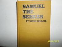
Samuel The Seeker
by Sinclair, Upton
- Used
- very good
- Hardcover
- first
- Condition
- Used - Very Good
- Jacket Condition
- No DJ Included
- Edition
- First Edition
- Binding
- Hardcover
- Quantity Available
- 1
- Seller
-
Salem, Oregon, United States
- Item Price
-
A$63.20A$37.92Save A$16.00!
Show Details
Description:
Sinclair, Upton. Samuel, The Seeker Copyright 1910. Apparently published by author. No publisher stated. First Edition. States printed at Western Printing and Lithography, Racine, WI. Yellow Boards with black titling. Used. Very Good/ No Dj is Included. Rare/Scarce. A nice copy.
Item Price
A$63.20A$37.92
Save A$16.00
!

Readin' 'Ritin' 'Rithmetic: Northern San Luis Obispo County Area One-Room Schools; Memories, Photos
by Anderson, Carilyn M. And Franklin, Harold A. And Nelson, Bonnie K. And Radford, Milene F. And Dollen
- Used
- very good
- Paperback
- Condition
- Used - Very Good
- Edition
- No Edition Stated
- Binding
- Paperback
- ISBN 13
- 9781929117093
- ISBN 10
- 1929117094
- Quantity Available
- 1
- Seller
-
Magalia, California, United States
- Item Price
-
A$39.42
Show Details
Description:
El Paso de Robles Area Pioneer Museum. Very Good. 2004. No Edition Stated. Softcover. 1929117094 . Light edgewear, corners of book have light curl, small indentation to front cover; b/w photos; 172 pages .
Item Price
A$39.42

More Photos
The DOs and DON'Ts of Yesterday: Little Book of Early American Know-How
by Eric Sloane
- Used
- Hardcover
- Signed
- Condition
- Like New
- Jacket Condition
- Very Good
- Binding
- Hardcover
- Quantity Available
- 1
- Seller
-
Orange, Virginia, United States
- Item Price
-
A$39.50
Show Details
Description:
Illustrated with pen/ink images Sloane is known for. (2) books,a yellow and an orange (18x12cm) with gilt title on covers and spines. Paper title on dark red slipcase with signature of author. Slipcase has very minor wear to bottom fore edge.
Item Price
A$39.50