The Amphibious Sketch: Its Function In Amphibious Training And Operations, Its Preparation And Reproduction Afloat, Together With Technical Hints On The Operation Of Seagoing Map Reproduction Units -
The Amphibious Sketch: Its Function In Amphibious Training and Operations, Its Preparation and Reproduction Afloat, Together With Technical Hints on the Operation of Seagoing Map Reproduction Units
- Used
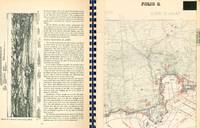
68 pp. restricted military publication on amphibious warfare including chapters on the preparation of panoramic drawings, the development of beach sketches, the development of shoreline sketches, variations in design, and technical information for drafting and reproduction. Profusely illustrated throughout with diagrams, 15 large folding maps and diagrams, and transparent overlays. 4to. Original pictorial printed wrpps., plastic ring binding. Very slight loss to ring binding, very slight soiling and toning, overall excellent condition. Washington, DC (United States Navy Hydrographic Office) 1945. Accompanied by a typed letter from Commander Allen B. Cook to Major Hugo Van Kuyck thanking him for his work in the field of beach intelligence essential to the invasion at Normandy, and passing along this volume obtained by Rear Admiral Robert O. Glover. According to the introduction from this volume, "The term 'Amphibious Sketch' is used to describe Beach Sketches, Shoreline Sketches or any similar sheet used to present this essential beach information required for an amphibious assault, the name 'Sketch' originating from the fact that the earliest ones were experimental and sketchy." Furthermore, a prefatory letter dated February 17, 1945 and written by E.J. King, Fleet Admiral, reads "The Amphibious Sketch is a weapon of war. The necessities of amphibious warfare have required its creation. In assisting assault personnel to establish a beachhead on a hostile shore, it has become a tool of victory and a new and needed addition to the field of cartography." The sketches for amphibious operations are meant to present in a single, panoramic graphic, as viewed from the sea, all evaluated and coordinated intelligence covering: hydrographic conditions on and offshore at the assault beaches (sand bars, water depth, tides, currents, etc.); characteristics of the beaches (nature of the bottom, extent of dunes, etc.); characteristics of the shoreline (natural and man-made landmarks); inland terrain; lines of communication and exits; and enemy defenses, where possible (wire, obstacles, mines, etc.). The examples in this volume include sketches developed for Mondello, Sicily, Salerno, Anzio, Southern France, Omaha Beach, and Woolacombe Sands. A fascinating and scarce volume; as of January 2018, WorldCat locates five copies in North American institutions.
-
Bookseller
Bernett Rare Books Inc
 (US)
(US)
- Book Condition Used
- Quantity Available 1
- Keywords BOSTON-VBF