Description:
London: T. Spilsbury for W. Herbert 2nd edition., 1768. Hardcover. Very Good. Double-page copper-plate bird's eye views (61 complete) of estates in Gloucestershire by J. Kip + double-page map of the county, plan & view of Gloucester City, and cathedral view + 8 single page plates with 320 small coats of arms.. Folio half brown calf and cloth sides with spine gilt titled (tips leather worn, spine rubbed & bottom edge shelf wear). Titlepage with decorative woodcut + [6]pp Preface & Advertisement +[16]pp coats of arms printed one side only + [2]pp author's epitaph and plate list + double-page Map of Glostershire +452pp + [6]pp Index. Ex-library with bookplate of Cheltenham Library Reference Department to pastedown + partially legible stamp of "Glos. Withd** for sale" to free endpaper. Light stain to top margin of title and 3/4-inch circular library stamp at foot, neat manuscript shelf mark & date on blank verso. The same small round purple stamp neatly placed on top corner margin & blank verso of each…
Read More Colton's Atlas of the World Vol. I and II 1856 1st Ed. Antique Book of Maps by George W. Colton
by George W. Colton
Similar copies are shown below.
Similar copies are shown to the right.

Colton's Atlas of the World Vol. I and II 1856 1st Ed. Antique Book of Maps
by George W. Colton
- Used
- very good
- Hardcover
- first
2 Large Folio Volumes J.H. COLTON & CO./TRUEBNER & CO, NEW YORK/LONDON, 1856. Illustrating physical and political geography. By George W. Colton. Accompanied by descriptions geographical, statistical, and historical by Richard Swainson Fisher, M.D. Volume I. - North and South America,Vol II. Europe,Asia, Africa, Oceanica,Etc. map plates. Brown embossed cloth, Faux leather rebind with a peel of original front and back. Maps very clean and bright. Ask questions!.
-
Bookseller
Rare & Antiquarian Bookfinders
 (US)
(US)
- Illustrator George Colton
- Format/Binding Brown embossed cloth, Faux leather rebind with a peel of original front and back.
- Book Condition Used - Very Good
- Jacket Condition No DJ
- Quantity Available 1
- Edition 1st
- Binding Hardcover
- Publisher J.H. COLTON & CO./TRUEBNER & CO,
- Place of Publication NEW YORK/LONDON
- Keywords Map
We have 1 copies available starting at A$2,212.14.
![THE ANCIENT AND PRESENT STATE OF GLOCESTERSHIRE [Gloucestershire] .. Second Edition. Illustrated...](https://d3525k1ryd2155.cloudfront.net/h/942/004/816004942.0.m.jpg)
THE ANCIENT AND PRESENT STATE OF GLOCESTERSHIRE [Gloucestershire] .. Second Edition. Illustrated with seventy-three copper-plates, Containing a Map of the County, a Plan and Prospect of the City, a View of the Cathedral, Sixty One Seats, and Three Hundred and Twenty Coats of Arms, of the Nobility and Gentry residing in the County at the Time of the first Publication.
by Atkyns, Sir Robert (1647-1711)
- Used
- very good
- Hardcover
- Condition
- Used - Very Good
- Binding
- Hardcover
- Quantity Available
- 1
- Seller
-
Blockley, Gloucestershire, United Kingdom
- Item Price
-
A$7,706.33
Show Details
Item Price
A$7,706.33
More Photos
RARE OTTOMAN MILITARY MAP OF KARA DAG (MONT NEGRO)
by Ottoman General Staff Section
- Used
- very good
- Condition
- Used - Very Good
- Quantity Available
- 1
- Seller
-
Riyadh, Saudi Arabia
- Item Price
-
A$7,900.50
Show Details
Description:
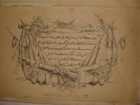
Istanbul: The general staff section, 1875 Map. Very Good. No Binding. Military map of Kara Dag (Mont Negro), Ottoman General staff section in 1291 (1875) after the map which made by the Austrian military geographical section in 1869 about Kara Dag and environs after the war and military movements of 1861-1862. Officially linen in colors by contemporary hands, 105 x 105 cm. Very rare..
Item Price
A$7,900.50

More Photos
Avrupa-i Osmani Haritasi (Wall map of the Ottoman Europe), extra ordinary copy of an Ottoman lieutenant
- Used
- very good
- Condition
- Used - Very Good
- Quantity Available
- 1
- Seller
-
Riyadh, Saudi Arabia
- Item Price
-
A$11,060.70
Show Details
Description:
205 x 137 cm. extra ordinary Ottoman wall map of the Ottoman Europe prınted ın colors, folding paper on cloth. Signatures by the first lieutenant M. İhsan.
Item Price
A$11,060.70

More Photos
The Reconquest of Peloponnese: MEMORIE ISTORIO GRAFICHE DE REGNI DELLA MOREA NEGROPONTE E LITTORALI FIN Á SALONICHI. ACERESCIUTE IN GUESTA SECONDA EDIZIONE
by CORONELLI, Vincenzo María
- Used
- Condition
- Used - Very Good+
- Edition
- Segunda
- Quantity Available
- 1
- Seller
-
Cuernavaca, Mexico
- Item Price
-
A$6,952.44
Show Details
Description:
Venezia, 1686En 8vo.6h, 237pp, 3h. Contemporary vellum. Title page with St Mark lion (engraved) . 41 (of 42?) maps and folded plates. Great condition.
2nd editionn (first in 8vo) published just the same year of the 1st, describing the Venetian campaign for the reconquer of the Peloponeso (or Morea). Venice had been excluded since the turquoise conquer of the greek island in 1458.
Vincenzo Maria Coronelli was an Italian Franciscan friar, cosmographer, cartographer, known in particular for his atlases and globes.
Item Price
A$6,952.44
More Photos
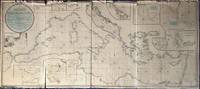
A New Chart of the Mediterranean Sea, Comprehending the Coasts from Cape St. Mary, (in Portugal) to Constantinople, and from Rabat, in Africa, to Alexandretto, or Iskenderoon, in Asia &c. Reduced from the new Spanish and French Charts made by Order of the respective Governments, From Several Documents of Lord Viscount Nelson, and other recent Authorities, By Joseph Dessiou, Master, &c.
by Dessiou (Joseph)
- Used
- Condition
- Used
- Binding
- Unknown
- Quantity Available
- 1
- Seller
-
Sidney, British Columbia, Canada
- Item Price
-
A$7,900.50
Show Details
Description:
London: Laurie, 2nd August, 1819. . A large copper engraved "blueback" map on paper, backed with the usual blue manila paper. Large coloured circular-bordered title in upper left, lettered in script. Entire map with contemporary colouring in outline. Thirteen small inset maps. Imprint at bottom: Published 2nd August, 1819, by Richard Holmes Laurie, Chart Seller to the Admiralty, &c.&c. No. 53, Fleet Street, London. Image size is 173cm x 76cm, on a sheet measuring 175cm x 78cm. The map is in five sections, four the same size and one smaller. Some splitting at folds, fraying to upper edge but very little loss, very good condition generally. Beneath the title is a note on the map: "Accompanied with an enlarged Book of Sailing Directions". WorldCat lists an edition of Laurie's book of directions [not present here]: "Laurie and Whittle's New Sailing Directions for the Mediterranean Sea ... Written to accompany the New Chart of the Mediterranean Sea, and compiled from the best Authorities, aided by several…
Read More Item Price
A$7,900.50

More Photos
Asia Distinguished in its Principall Parts uiz Turky in Asia, Arabia, Persia, India, China, Tartaria, The Islands of Japan, of the Philippines, of the Moluckes, of the Sundaes, of Ceylan, and of the Maldivies, where are set down the Empires, Monarchies...
by Sanson, (Nicolas)/Berry, William
- Used
- Condition
- Used - Gut
- Binding
- Unknown
- Quantity Available
- 1
- Seller
-
Velbert, Germany
- Item Price
-
A$9,072.45
Show Details
Description:
London: William Berry, 1680. ...Kingdoms, and States, which are found there at present/Described by Sanson/Corrected and amended By William Berry (=Kopftitel); Text der figürlich reich verzierten Kartusche oben rechts: Asia Divided into its Principall Regions in which may be seen the extent of the Empires Monarchies Kingdoms and States which at present divide Asia/To the Most serene and Most Sacred Majesty of Charles II./By the Grace of God King of Great Britain, France and Ireland/This Map of Asia is humbly Dedicated and Presented By Your Majesties Loyal Subject and Servand William Berry; Text der reich verzierten Kartusche links oben: Scale (es folgen Maßstäbe verschiedener Länder)/London/Sold by William Berry at the Sign of the Globe between Charing-Cross and White-Hall/1680; SW-Kupferstich-Landkarte nach (Nicolas) Sanson (d'Abbeville) gestochen von William Berry; ca. 51 x 39 cm; Falzspuren, einige Tintenflecken, hauptsächlich ausserhalb des Druckbildes, mässige…
Read More Item Price
A$9,072.45

More Photos
A Modern, Authentic and Complete System of Universal Geography
by Rev. Thomas Bankes
- Used
- very good
- Hardcover
- Condition
- Used - Very Good
- Binding
- Hardcover
- Quantity Available
- 1
- Seller
-
Farningham, Kent, United Kingdom
- Item Price
-
A$6,782.36
Show Details
Description:
London: C.Cooke, 1793 Undated circa 1793. The content based on information received up until 1793. 6+990pp+2 - 88 plates, 22 maps. Whilst the scope purports to be the genuine history and description of the Whole World, such was the importance of Cook's discoveries that the first 106pp incorporating 25 plates and three maps is taken up with Cook's voyages. To this is included a particular description of the improved state of the New Colony formed at Port Jackson and Norfolk Island, where the convicts are now settled, and an account of the excursions and discoveries made in the interior parts of New Holland. Altogether this is a gargantuan production with stunning plates and maps. Contemporary full calf, superbly rebacked with the original spine relaid. Photographs available on request.
Item Price
A$6,782.36
More Photos
RARE OTTOMAN MILITARY MAP OF KARA DAG (MONT NEGRO)
by Ottoman General Staff Section
- Used
- very good
- Condition
- Used - Very Good
- Quantity Available
- 1
- Seller
-
Riyadh, Saudi Arabia
- Item Price
-
A$7,900.50
Show Details
Description:
Istanbul: The general staff section, 1875 Map. Very Good. No Binding. Military map of Kara Dag (Mont Negro), Ottoman General staff section in 1291 (1875) after the map which made by the Austrian military geographical section in 1869 about Kara Dag and environs after the war and military movements of 1861-1862. Officially linen in colors by contemporary hands, 105 x 105 cm. Very rare..
Item Price
A$7,900.50
More Photos
The Reconquest of Peloponnese: MEMORIE ISTORIO GRAFICHE DE REGNI DELLA MOREA NEGROPONTE E LITTORALI FIN Á SALONICHI. ACERESCIUTE IN GUESTA SECONDA EDIZIONE
by CORONELLI, Vincenzo María
- Used
- Condition
- Used - Very Good+
- Edition
- Segunda
- Quantity Available
- 1
- Seller
-
Cuernavaca, Mexico
- Item Price
-
A$6,952.44
Show Details
Description:
Venezia, 1686En 8vo.6h, 237pp, 3h. Contemporary vellum. Title page with St Mark lion (engraved) . 41 (of 42?) maps and folded plates. Great condition.
2nd editionn (first in 8vo) published just the same year of the 1st, describing the Venetian campaign for the reconquer of the Peloponeso (or Morea). Venice had been excluded since the turquoise conquer of the greek island in 1458.
Vincenzo Maria Coronelli was an Italian Franciscan friar, cosmographer, cartographer, known in particular for his atlases and globes.
Item Price
A$6,952.44

More Photos
A General Atlas, containing Maps illustrating some important periods in Ancient History and distinct Maps of the several Empires, Kingdoms and States in the World,: From Original Drawings according to the latest Treaties by J. Wyld and Engraved by N. R. Hewitt
by WYLD, James
- Used
- very good
- Hardcover
- Condition
- Used - Very good
- Edition
- Second Edition
- Binding
- Hardcover
- Quantity Available
- 1
- Seller
-
London, Ontario, Canada
- Item Price
-
A$9,480.60
Show Details
Description:
Edinburgh: Printed for John Thomson & Co. for Baldwin, Craddick & Joy, London, & John Cumming, Dublin, ca. 1819-1825. Second Edition. Hardcover. Very good. xxviii, Plates, 18 p. 38 cm. Frontispiece Mountains table, title page vignette, engraving p. viii, 8 in-text illustrations before plates (6 colour, 2 tables), 44 engraved hand-coloured plates, most with small vignettes. Bound in half leather with marbled paper boards. New endpapers. Signed by previous owner William Hossack (1829) on front and rear endpapers. Foxing. Repaired edges to plates 36 & 37. An attractive atlas engraved by N. R. Hewitt from maps drawn by James Wyld the Elder (1790-1836). One of the foremost geographers of his time, Wyld is credited with introducing lithography to map printing during the Peninsula Campaign in 1812. A prolific publisher, he is reputed to have died of overwork. The detailed maps in this atlas emphasize Europe but there are several maps showing the Americas and Australia. Most maps feature a vignette…
Read More Item Price
A$9,480.60

Colton's Atlas of the World (Vol. 2 Only)
by Colton, George W
- Used
- Hardcover
- first
- Condition
- Used - Binding poor, contents very good
- Edition
- 1st
- Binding
- Hardcover
- Quantity Available
- 1
- Seller
-
Pittsford, New York, United States
- Item Price
-
A$2,212.14
Show Details
Description:
New York: J.H. Colton & Co.. Binding poor, contents very good. 1856. 1st. hardcover. Folio, Backstrip partially detached; rear board detached; bookblock intact, Second volume of a two volume set with 49 maps (some double plates, some hand-colored) of Europe, Asia, Africa & Oceania. Previous owner has lightly stamped his name in the margins of the plates, not affecting the images. No foxing. .
Item Price
A$2,212.14

More Photos
The Sky and the Forest
by Forester, C.S
- Used
- very good
- Hardcover
- first
- Condition
- Used - Very Good
- Jacket Condition
- Very Good
- Edition
- First Edition
- Binding
- Hardcover
- Quantity Available
- 1
- Seller
-
Salem, Oregon, United States
- Item Price
-
A$55.13A$33.07Save A$13.96!
Show Details
Description:
C.S. Forester: The Sky and the Forest. Little, Brown and Company, Boston. Stated First Edition First Printing Thus August, 1948. Cover price $2.75. Used. VG BOOK/VG UNCLIPPED DUST JACKET. A story of a central Africa. By C.S. Forester, author of the Admiral Hornblower series.
Item Price
A$55.13A$33.07
Save A$13.96
!
![Alaska and Klondike Region; [With inset of Klondike Region on the Upper Yukon detail] [From an...](https://d3525k1ryd2155.cloudfront.net/h/062/537/1339537062.0.m.jpg)
Alaska and Klondike Region; [With inset of Klondike Region on the Upper Yukon detail] [From an atlas, "Gazetteer of Alaska and Yukon Region " pp. 105 and 106]
by Miller, J. Martin
- Used
- very good
- Condition
- Used - Very Good
- Edition
- Unknown
- Quantity Available
- 1
- Seller
-
Sebastopol, California, United States
- Item Price
-
A$61.62
Show Details
Description:
Chicago: J. Martin Miller, 1899. Unknown. Map. Very Good. [Map copyright 1899, printing date of Atlas later] [19.875x15.125in]; Colored map of Alaska with steamer routes from Portland and Seattle, insets of the Klondike Region on the Upper Yukon and Western portion of Aleutian Islands; On verso index of places and names with two large black and white images; Age toning to all edges, water stain marks on bottom, slight printing offset of colors, small chips and closed tears to lower edge;.
Item Price
A$61.62

Zemepis Sveta - Monsunova Asie
by De La Blache, P. Vidal; Gallois, L
- Used
- Hardcover
- Condition
- Used - Very Good Condition
- Jacket Condition
- No Dust Jacket
- Binding
- Hardcover
- Quantity Available
- 1
- Seller
-
Oak Point, Texas, United States
- Item Price
-
A$94.81
Show Details
Description:
Aventinum, Prague, Czechoslovakia, 1931. Hardcover. Very Good Condition/No Dust Jacket. Text entirely in Czech. Geography book on Asia with numerous photographs and maps. 1930 edition also available. Size: 4mo - over 9 3/4" - 12" tall. 400 pp. Pages are yellowed, but are tight and clean. Moderate shelfwear along the spine. Corners are lightly bumped. Quantity Available: 1. Shipped Weight: 3-5 pounds. Category: Travel & Places; Non-English Language::Czech; Pictures of this item not already displayed here available upon request. Inventory No: 001228. . Additional shipping charges may apply.
Item Price
A$94.81

Zemepis Sveta - Monsunova Asie
by De La Blache, P. Vidal; Gallois, L
- Used
- Hardcover
- Condition
- Used - Very Good Condition
- Jacket Condition
- No Dust Jacket
- Binding
- Hardcover
- Quantity Available
- 1
- Seller
-
Oak Point, Texas, United States
- Item Price
-
A$94.81
Show Details
Description:
Aventinum, Prague, Czechoslovakia, 1930. Hardcover. Very Good Condition/No Dust Jacket. Text entirely in Czech. Geography book on Asia with numerous photographs and maps. 1931 edition also available. Size: 4mo - over 9 3/4" - 12" tall. 400 pp. Pages are yellowed, but are tight and clean. Moderate shelfwear along the spine. Corners are lightly bumped. Quantity Available: 1. Shipped Weight: 3-5 pounds. Category: Travel & Places; Non-English Language::Czech; Pictures of this item not already displayed here available upon request. Inventory No: 001227. . Additional shipping charges may apply.
Item Price
A$94.81

North America from the Best Authorities, Russell, ca.1800
by Russell
- Used
- Condition
- Used
- Quantity Available
- 1
- Seller
-
Plymouth, Devon, United Kingdom
- Item Price
-
A$39.32
Show Details
Description:
Russell, J. : A General Map of North America from the Best Authorities. Nd but ca.1800. From "A New Geographical, Historical and Commercial Grammar and Present State of Several Kingdoms of the World." Copper engraving. Size approx 200 x 230mm. Two neat folds. Some age colouring to edges, otherwise very clean and bright.
Item Price
A$39.32

Asia from the Best Authorities, Russell, ca.1800
by Russell
- Used
- Condition
- Used
- Quantity Available
- 1
- Seller
-
Plymouth, Devon, United Kingdom
- Item Price
-
A$39.32
Show Details
Description:
Russell, J. : Asia from the Best Authorities. Nd but ca.1800. From "A New Geographical, Historical and Commercial Grammar and Present State of Several Kingdoms of the World". Copper engraving. Size approx 200 x 230mm. Two neat folds. Some age colouring to edges, otherwise clean and bright. Includes Arabia, India, Borneo, Japan, China and eastern Russia.
Item Price
A$39.32
![MAP OF UTAH [Territory]](https://d3525k1ryd2155.cloudfront.net/h/836/461/1485461836.0.m.jpg)
More Photos
MAP OF UTAH [Territory]
- Used
- Condition
- Used - Very Good-
- Edition
- Original
- Quantity Available
- 1
- Seller
-
Williamsburg, Virginia, United States
- Item Price
-
A$102.71
Show Details
Description:
New York, Richmond, Chicago, & Toledo: H. H. Hardesty, 1885. Original color lithographed map printed by Rand, McNally & Company, Engravers and published in HARDESTY'S HISTORICAL AND GEOGRAPHICAL ENCYCLOPEDIA: SPECIAL VIRGINIA EDITION. 19 3/8 inches by 13 1/4 inches on a 21" X 14 1/2" sheet. The map depicts the Territory of Utah in its final form--large areas had been removed and ceded to Nevada, Colorado, Wyoming, and Nebraska since Utah became a U. S. Territory in 1850. The issue of polygamy prevented statehood until it was finally granted in 1896. This map features railroads and topography and uses color to set off counties from each other. Unlike most atlas maps of the period, this map identifies most small towns. The map is guaranteed to be moe than 135 years old. The map is in about very good condition: generally clean and bright, with slight toning of paper and one faint water stain near the center-left edge of the map.. Original. Single Sheet. Very Good-. Elephant…
Read More Item Price
A$102.71

Last Tales
by Dinesen, Isak
- Used
- very good
- Hardcover
- first
- Condition
- Used - Very Good
- Jacket Condition
- Good+
- Edition
- First Edition
- Binding
- Hardcover
- Quantity Available
- 1
- Seller
-
Salem, Oregon, United States
- Item Price
-
A$189.61A$113.77Save A$48.00!
Show Details
Description:
Dinesen, Isak: Last Tales, A Collection of Twelve New Tales of Compelling Beauty 1957, Random House. First Edition. Stated First Printing Thus. Used. Very Good/Good+ original red dust jacket, price-clipped. Jacket states 11/57 on front flap. 5 3/4 X
Item Price
A$189.61A$113.77
Save A$48.00
!

Philips Special Map of the Nile, The Advance on Khartum and the Environs of Omdurman. Cc1900
by George Philips and Son,
- Used
- Condition
- Used
- Quantity Available
- 1
- Seller
-
Plymouth, Devon, United Kingdom
- Item Price
-
A$51.11
Show Details
Description:
Philips Special map of the Nile illustrating the Advance on Khartum [Khartoum] with an enlargement of the environs of Omdurman [Omdur]. George Philips and Son, London and Liverpool Ca 1900. 580mm x 900mm folded map. Front title wrapper has come loose, not affecting map area. Three maps are displayed within the sheet. Map1. Map of the Nile Valley 520mm x 300mm showing the approaches of Khartum. Scale 1inch to 100 Geographical miles. Coloured indicating Possessions and Protectorates of European Powers. Map 2. Special map of the Nile from Dongola to Khartum. Scale 16 miles to the inch. Coloured. In set in this map is Map3. Environs of Omdurman, Scale 5 statute miles to the inch. Some small breaks at some folds, not affecting imagery or use of map. Title label is damaged, the map is clean and bright, probably unused. A very interesting record.
Item Price
A$51.11

The Adventure of Wrangel Island
by Vilhjalmur Stefansson
- Used
- good
- Hardcover
- first
- Condition
- Used - Good
- Jacket Condition
- No DJ Included
- Edition
- First Edition
- Binding
- Hardcover
- Quantity Available
- 1
- Seller
-
Salem, Oregon, United States
- Item Price
-
A$197.34A$118.40Save A$49.96!
Show Details
Description:
The Adventure of Wrangel Island, Alaska (1925 Macmillan 1st Edition) HISTORY OF ALASKA. EXLIB. Good Condition/ No DJ included. Fold-out map affixed to binding at the back of the book has never been opened. The story of the (unsuccessful) attempted colonization of Wrangel Island Alaska. 413 pages plus appendix, Index. Titling is still bright. A clean, solid copy. Scarce.
Item Price
A$197.34A$118.40
Save A$49.96
!