Description:
Tallis, John: Northern Italy, London. [ca.1851]. From the Montgomery Martin Illustrated Atlas. Map engraved by Rapkin. Size approx 360 x 260mm. Original steel engraved map with original outline hand colouring. 4 vignette views including The Grand Canal Venice and St Peters Rome, Decorative border. Single page unfolded map in excellent, clean condition. Associated text page of the Montgomery Martin Atlas included. A Good Tallis Map.
The English Atlas by PITT, Moses (ca. 1639-1697) - 1680
by PITT, Moses (ca. 1639-1697)
Similar copies are shown below.
Similar copies are shown to the right.
The English Atlas
by PITT, Moses (ca. 1639-1697)
- Used
- Fine
- Hardcover
- first
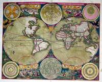
Printed at the Theater, for Moses Pitt at the Angel in St.. Pauls Church-Yard, London, 1680-1681-1683-1682, 1680. 4 volumes. Folio (21 4/8 x 14 inches). Letterpress title-pages, two printed in red and black and with small engraved vignettes, letterpress in volume one ruled in red throughout. Fine engraved portrait of Charles II, engraved by R. White, in volume one by (laid down on heavier stock at an early date) and double-engraved plate of Laplanders by F. van den Houe with magnificent original hand-colour in full, 3 further folding plates and 166 double-page maps of the world by John Seller and Janssonius and Northern Europe, all with original hand-colour in part, the cartouches with original hand-colour in full, those in volume one occasionally HEIGHTENED IN GOLD and gum arabic, all cartouches and other fine details in volume IV HEIGHTENED IN GOLD and gum arabic, all maps in this volume ruled in red (world map by Seller trimmed and laid down on heavier stock, volume one without map 35 'Ducatus Stomariae' and 40 'Regni Norvegiae'; map 35 in volume II 'Marchia Vetus' trimmed and laid down on heavier stock; volume III with maps 'Totius Sveviae', 'Walachia' and 'Iuliacensis Ducatus' trimmed and laid down, without map 126 'Diocesis Leodeniensi' but with additional map 'Oldenburg'; volume IV lacking map 141 'Fossa Eugeniana' but with additional map 'Namurcum Comitatus'). Fine contemporary blind paneled smooth and mottled calf, the spines in 8 compartments with 7 raised bands, one lettered in gilt, the others decorated with fine gilt tools (expertly rebacked preserving the original backstrips, a bit rubbed). Provenance: with the engraved armorial bookplate of George Tollet Esq. (d. 1719), mathematician and naval administrator, on the verso of each title-page; with the engraved armorial bookplate of the Weston Library of the Earls of Bradford on each front paste-down. First edition. The two world maps are John Seller's "Novissima Totius Terrarum Orbis Tabula..." (Shirley 460) and Pieter van den Keere's "Nova totius terrarum orbis geographica ac hydrographica tabula" in the revised Janssonius, post 1620, state (Shirley 504) with a dedication to the Bishop of Oxford in the upper left. The map of the North Pole is Janssonius's "Nova et accurata Poli Arctici" and not that of Moses Pitt. The remaining maps are of Northern and Eastern Europe, all based on Dutch cartography, as Pitt's intention had been to publish a mammoth atlas to rival that of Blaeu, "giving a reprise to many of the plates which Janssonius had acquired over the years, some of them going as far back as the stocks that were used for Mercator's Atlas" (Goss) . However, as with many grand publishing designs the venture faltered after only these four volumes. The maps in volume one, in addition to the world map, and that of the Arctic, are of Russia, Poland, and Scandinavia; volumes II and III are of the German Empire; and IV contains the Seventeen Provinces of the Low Countries, or Netherlands. Moses Pitt was neither a cartographer nor a scholar, yet in 1670 he undertook a project that came to be called 'The English Atlas'. Despite the seemingly difficult, if not unrealistic, task at hand--hardly mitigated by the paucity of skilled commercial cartographers in England--Pitt's endeavor was backed by Sir Christopher Wren and Robert Hooke, and his partners included the Dutch map publisher Jan Jansson and the Englishman Steven Stewart. Based on the concept of the Atlas Maior by Joan Blaeu ,Pitt's atlas was to consist of twelve volumes, but only four were completed (covering places "next to the North-pole," Muscovy, Poland, Sweden, Denmark, Germany and the seventeen provinces of the Low Countries). Pitt had envisioned the project as a reissue of a Dutch atlas in "English guise"--in which existing Dutch maps would be repackaged with accompanying text in English--whereas his partners envisioned the printing of an atlas with entirely new maps. Such conflicts, along with economic factors and the overly ambitious nature of the project envisioned, eventually led to its demise. After only four parts of the atlas were completed, Pitt was in financial ruin and was imprisoned for debt from 1689 to 1691. Nonetheless, the four volumes that were produced signal the sumptuous nature of the project, as the highest production values were lavished upon it in terms of engraving, paper and coloring. From the distinguished library of George Tollet, who in 1683 became a founder member of the Dublin Philosophical Society—"a sister organization to the Royal Society—and would become one of its more active members: his experiments and presentations, as well as his correspondence with other scientists, including Edmond Halley, are often remarked upon in its minute book, which records his election to the position of treasurer on 2 November 1685... several of Tollet's contributions to the Dublin society's meetings involved applied mathematics—he presented papers on gunnery and on longitude, for example—...In 1688 Tollet moved to England. Luttrell's parliamentary diary reports that Tollet was chosen secretary to the ‘commissioners for taking the public accounts’ in March 1691; was made ‘comptroller of the foreign post office in the room of Mr Brocket’ in May 1697; took a post at ‘the custome house’ in November 1697; and in June 1700 was made ‘secretary of the excise, worth £500 per annum’ (Luttrell, 2.192; 4.219, 306, 661). Not mentioned in Luttrell's diary, but noted by both Hinchliffe and Speake, is Tollet's appointment as accountant-general of Ireland, granted in December 1691" (Michael Londry for DNB). And from the library of the Earls of Bradford, probably Henry Bridgeman, first Baron Bridgeman (1725-1800) who inherited Weston Park from his mother's family in 1762. E. G. R. Taylor, "The English Atlas of Moses Pitt, 1680-83," Geographical Journal 95, 4 (April 1940), 292-299; Lloyd Arnold Brown, The World Encompassed, exh. cat. (Baltimore, 1952), n. 172; Rodney W. Shirley, The Mapping of the World (London, 1983), n. 504. Catalogued by Kate Hunter. 1st Edition. Full Leather. Fine. Atlas.
-
Bookseller
Arader Galleries
 (US)
(US)
- Format/Binding Hardcover
- Book Condition Used - Fine
- Edition 1st Edition
- Binding Hardcover
- Publisher Printed at the Theater, for Moses Pitt at the Angel in St.. Pauls Church-Yard, London, 1680-1681-1683-1682
- Date Published 1680
We have 6 copies available starting at A$313.76.

Northern Italy, Tallis, ca.1851: Original Antique Map.
by John Tallis & Rapkin
- Used
- Condition
- Used
- Edition
- 1st Edition
- Quantity Available
- 1
- Seller
-
Plymouth, Devon, United Kingdom
- Item Price
-
A$97.30
Show Details
Item Price
A$97.30

Turkey in Asia,: Original 19th Century Map
by John Tallis and Rapkin
- Used
- very good
- Condition
- Used - Very Good
- Edition
- 1st edition
- Quantity Available
- 1
- Seller
-
Plymouth, Devon, United Kingdom
- Item Price
-
A$116.75
Show Details
Description:
Tallis, John: Turkey in Asia. London. [ca.1851]. From the Montgomery Martin Illustrated Atlas. Map engraved by Rapkin. Size approx 360 x 260mm. Original steel engraved map with original outline hand colouring. 4 vignettes include Jerusalem and the Castles of Europe and Asia. The map area covers modern day Turkey, Cyprus, Israel, Lebanon, Syria, Jordan and Iraq. Decorative Border. Single page unfolded map in excellent, clean condition. Associated text page of the Montgomery Martin Atlas included.
Item Price
A$116.75

More Photos
Plan of the Battle of Waterloo
by Edward Cotton
- Used
- good
- Hardcover
- Condition
- Used - Good
- Binding
- Hardcover
- Quantity Available
- 1
- Seller
-
Boonsboro, Maryland, United States
- Item Price
-
A$499.66
Show Details
Description:
1854. Hardcover. Good. Lithograph map with original hand-colored highlights. Approximately 12 1/4 X 12 1/2" on 18 X 18" sheet with extensive printed text at all margins. Title and credit in the map at upper right, good condition with some aging at folds. <br> Original slim 12mo dark green leather-covered board folder with gilt lettering at upper cover. Some scuffing and wear at edges. Additional smaller lithograph map with hand-colored highlights mounted at inside of upper cover. Lengthy 1858 pencil notation of purchase ("on the Field of Waterloo") from Cotton's niece on verso of map.
Item Price
A$499.66
More Photos
RARE OTTOMAN MILITARY MAP OF KARA DAG (MONT NEGRO)
by Ottoman General Staff Section
- Used
- very good
- Condition
- Used - Very Good
- Quantity Available
- 1
- Seller
-
Riyadh, Saudi Arabia
- Item Price
-
A$7,844.00
Show Details
Description:
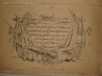
Istanbul: The general staff section, 1875 Map. Very Good. No Binding. Military map of Kara Dag (Mont Negro), Ottoman General staff section in 1291 (1875) after the map which made by the Austrian military geographical section in 1869 about Kara Dag and environs after the war and military movements of 1861-1862. Officially linen in colors by contemporary hands, 105 x 105 cm. Very rare..
Item Price
A$7,844.00

More Photos
Avrupa-i Osmani Haritasi (Wall map of the Ottoman Europe), extra ordinary copy of an Ottoman lieutenant
- Used
- very good
- Condition
- Used - Very Good
- Quantity Available
- 1
- Seller
-
Riyadh, Saudi Arabia
- Item Price
-
A$10,981.60
Show Details
Description:
205 x 137 cm. extra ordinary Ottoman wall map of the Ottoman Europe prınted ın colors, folding paper on cloth. Signatures by the first lieutenant M. İhsan.
Item Price
A$10,981.60

More Photos
Le nouveau et curieux Atlas Geographique et historique...
by Chiquet (Jacques) [Antoine Menard].
- Used
- Hardcover
- Condition
- Used
- Binding
- Hardcover
- Quantity Available
- 1
- Seller
-
Sidney, British Columbia, Canada
- Item Price
-
A$3,529.80
Show Details
Description:
Paris: chez Chereanau, [1719].. Oblong small 4to. Full vellum with ties. Wear at edges, chip from fore-edge of lower front cover,blank end leaves are heavily annotated and written-upon in 18th & 19th century hands. Old stains to margins and a few maps, old paper-tape repairs to the verso of the Asia map, but generally very good. Engraved allegorical title page, 3 plates (two of globes), and 24 maps opposite explanatory text in French. 23 maps have contemporary hand-colouring in outline; a couple have attractively coloured cartouches. The Globe Terrestre map, of two hemispheres, is holed, slightly affecting the title. The map of North America shows California as an island. This is the second or third edition of this atlas, originally by Antoine Menard, first published by Chiquet in [1711 & 1713], with most of the maps dated 1709-1711. In this 1719 edition Chiquet has removed Menard's name entirely; on many of the maps (such as L'Amerique Septentrionale) he has changed it to his own name and altered…
Read More Item Price
A$3,529.80

More Photos
Arab navigation in the Indian Ocean before the coming of the Portuguese
by Ahmad ibn Majid al-Sadi , G.R. Tibbetts
- Used
- Hardcover
- first
- Condition
- Very Good: Cover some light shelf wear, inside as new
- Edition
- First Edition
- Binding
- Hardcover
- ISBN 10 / ISBN 13
- 9780718909000 / 0718909003
- Quantity Available
- 1
- Seller
-
Berg en dal, Netherlands
- Item Price
-
A$401.88
Show Details
Description:
Ahmad ibn Majid al-Sadi, G.R. Tibbetts - Arab Navigation in the Indian Ocean before the coming of the Portuguese - London, The Royal Asiatic Society of Great Britain and Ireland; Luzac and Company Ltd, 1971 - First Edition - Hardcover - 614pp + 4 maps (out of 7)- 22x14 cmCondition Very Good: Cover some light shelf wear, inside as new. Four out of seven maps present: Chart of the Arabian Sea, India and the Bay of Bengal, Red Sea and Gulf of Eden, East African CoastIf you have any questions or want to see more pictures, feel free to ask.Your book will be securely packed and shipped with tracking number, signed & insured.
Item Price
A$401.88
![Alaska and Klondike Region; [With inset of Klondike Region on the Upper Yukon detail] [From an...](https://d3525k1ryd2155.cloudfront.net/h/062/537/1339537062.0.m.jpg)
Alaska and Klondike Region; [With inset of Klondike Region on the Upper Yukon detail] [From an atlas, "Gazetteer of Alaska and Yukon Region " pp. 105 and 106]
by Miller, J. Martin
- Used
- very good
- Condition
- Used - Very Good
- Edition
- Unknown
- Binding
- Unknown
- Quantity Available
- 1
- Seller
-
Sebastopol, California, United States
- Item Price
-
A$61.18
Show Details
Description:
Chicago: J. Martin Miller, 1899. Unknown. Map. Very Good. [Map copyright 1899, printing date of Atlas later] [19.875x15.125in]; Colored map of Alaska with steamer routes from Portland and Seattle, insets of the Klondike Region on the Upper Yukon and Western portion of Aleutian Islands; On verso index of places and names with two large black and white images; Age toning to all edges, water stain marks on bottom, slight printing offset of colors, small chips and closed tears to lower edge;.
Item Price
A$61.18
More Photos
Napa County California. 1914
by Copyright 1914 by Punnett Brothers
- Used
- Condition
- Used
- Quantity Available
- 1
- Seller
-
FRAMINGHAM, Massachusetts, United States
- Item Price
-
A$1,490.36
Show Details
Description:
Map Details and Condition:color lithograph
dimensions: 26 3/4" x 19"
Brown Paper pocket covers with red bookstore label of Neal Stratford & Kerr, San Francisco
condition: professionally flattened and otherwise in as found, very good conditionDescription:
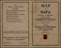
This 1914 map of now popular wine country Napa County, California shows the county in 1914, with early roads, largely undeveloped, vast open land areas, and natural features. The numbered grid system on this map reflects the Public Land Survey System. Large open tracts of land are identified as ranches, such as Rancho Catacoula, or Rancho Las Putas, Rancho LaJota all of which are large swaths of undivided land. Urban grids are shown in the southernmost part of Napa County, and sections of the southernmost sections of Sonoma County and Solano County. The cities of Petaluma, Sonoma, Vallejo and Napa and Benicia show populated urban areas. A corner of Marin County is shown.
C.F. Weber & Co. and the Punnett Brothers published… Read More
Item Price
A$1,490.36

More Photos
Britannicae Insulae: Antique map of Great Britain
by Robert de Vaugondy
- Used
- very good
- Condition
- Used - Very Good
- Quantity Available
- 1
- Seller
-
Providence, Seychelles
- Item Price
-
A$274.54
Show Details
Description:
FULL TITLE: Britannicae, Insulae in quibus Albion Seu Britannia Major, et Ivernia seu Britannia Minor juxta Ptolemaei mentem divisae tùm in suas majores partes, tùm in populos exhibentur, à Nicolao sanson Christ, Regis Geographo, Revisae, et ad observationes astronomicas redactae, accurante Robert de Vaugondy filio, gum Privilegio Regis'DATE PRINTED: 1750 IMAGE SIZE: Approx 50.0 x 55.0cm, 19.5 x 21.5 inches (Large); Please note that this is a folding map.TYPE: Large antique 18th-century atlas map, printed on thick, good quality paper. partially hand-colored.CONDITION: Good; suitable for framing. Please check the scan for any blemishes prior to making your purchase. Virtually all antiquarian maps and prints are subject to some normal aging due to use and time which is not obtrusive unless otherwise stated. We offer a no-questions-asked return policy.AUTHENTICITY: This is an authentic historic map, published at the date stated above. It is not a modern copy.VERSO: Short map title printed on the…
Read More Item Price
A$274.54

The English Atlas. Volume II. ENGRAVED TITLE PAGE.
by Pitt, Moses
- Used
- Condition
- Used
- Quantity Available
- 1
- Seller
-
Fallon, Nevada, United States
- Item Price
-
A$313.76
Show Details
Description:
[London:], 1681.. 27 x 40.5cm. Single leaf.. Engraved title page to volume two, trimmed just outside borders. Minor tape remnants on left border. Mounted on larger plain leaf. Suitable for framing. Fine engraved title page to volume 2, with German Emperor and his courtiers, surmounted by German double-headed eagle, and coat of arms.
Item Price
A$313.76
![[Title-page] The English Atlas, Volume II](https://d3525k1ryd2155.cloudfront.net/h/989/308/139308989.0.m.jpg)
[Title-page] The English Atlas, Volume II
by Pitt, Moses:
- Used
- Condition
- Used
- Quantity Available
- 1
- Seller
-
London, United Kingdom
- Item Price
-
A$632.42
Show Details
Description:
London, 1681. Copper engraved title-page, 40.5 x 26.5 cms, black and white as issued, blank verso. Four volumes only of Pitt’s projected eleven volume world atlas were published 1680-83, all dealing with northern Europe. Pitt worked in partnership with Janssonius’ heir Joannes van Waesbergen, and this title-page for the German volume is a reworking of one engraved for Janssonius forty years earlier. The Holy Roman Emperor is now Leopold I, the faces of the other Electors have also been updated, and a there is a considerable amount of additional background detail. Shirley, Courtiers and Cannibals, 48A. Map
Item Price
A$632.42
The English Atlas. TITLE PAGE ENGRAVING.
by Pitt, Moses
- Used
- first
- Condition
- Used
- Edition
- From the first edition.
- Quantity Available
- 1
- Seller
-
Fallon, Nevada, United States
- Item Price
-
A$784.40
Show Details
Description:
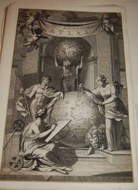
[Oxford:]: [for J, Jansonius a Waesberge, Moses Pitt and Steven Swart,], [1680].. From the first edition.. 46 x 29.5cm.. Stunning, large allegorical title page by J. van Munnikhuysen after Zacharias Webbers. Trimmed at borders. Few minor edge tears, repaired, top one just barely touching cherub, no true affect to the illustration, overall it is a beautiful piece from a very rare and important. Most suitable for framing. Mounted on larger plain leaf. Based on the concept of Atlas Major by Joan Blaeu, PittÕs atlas was to be made of twelve volumes, but only four were completed when Pitt was imprisoned for debt. The title page illustrates mythical figures Neptune at the left of a large globe, and Cybele, Mother Godess of Earth at the right, with lion at her feet, in the background Atlas is shown holding a celestial globe on his shoulders, a seated muse is in front representing history. Wing P2306. NMM 410.
Item Price
A$784.40
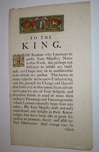
Dedication page to Charles II from The English Atlas. First edition.
by Pitt, Moses
- Used
- Condition
- Used
- Quantity Available
- 1
- Seller
-
San Francisco, California, United States
- Item Price
-
A$784.40
Show Details
Description:
London: Printed at the Theater, for Moses Pitt , 1680. Letterpress with 2 engravings: Portrait of the king and inhabited initial, both handcolored. 57.5 x 33.5cm.
Item Price
A$784.40

The English Atlas. Volume 1. Containing a Description of the Places next the North-Pole; as also of Muscovy, Poland, Sweden, Denmark, and their several dependances
by Pitt, Moses and Oskar Halecki
- Used
- Condition
- Used - Collectible - Acceptable
- Quantity Available
- 1
- Seller
-
Frederick, Maryland, United States
- Item Price
-
A$3,441.45
Show Details
Description:
Z. Tehinka. Collectible - Acceptable. New York: Z. Tehinka, 1943. Reprint of 1680 edition. Volume 1. Folio. 28pp. Maps. Fair book. Spine cover missing. Board covers considerably chipped, though without text loss. Front board detached. Preface through p. 26 detached. (Poland, maps, history, travel) Inquire if you need further information.
Item Price
A$3,441.45
The English Atlas. Volume 1. Containing a Description of the Places next the North-Pole; as also of Muscovy, Poland, Sweden, Denmark, and their several dependences
by Pitt, Moses and Oskar Halecki
- Used
- Hardcover
- Condition
- Used - Collectible - Acceptable
- Binding
- Hardcover
- Quantity Available
- 1
- Seller
-
Frederick, Maryland, United States
- Item Price
-
A$3,441.45
Show Details
Description:
Z. Tehinka. Collectible - Acceptable. New York: Z. Tehinka, 1943. Reprint of 1680 edition. Volume 1. Folio. 28pp. Maps. Fair book. Bottom 6" of both boards dampstained. (Poland, maps, history, travel) Inquire if you need further information.
Item Price
A$3,441.45

More Photos
The Sky and the Forest
by Forester, C.S
- Used
- very good
- Hardcover
- first
- Condition
- Used - Very Good
- Jacket Condition
- Very Good
- Edition
- First Edition
- Binding
- Hardcover
- Quantity Available
- 1
- Seller
-
Salem, Oregon, United States
- Item Price
-
A$54.74A$32.83Save A$13.96!
Show Details
Description:
C.S. Forester: The Sky and the Forest. Little, Brown and Company, Boston. Stated First Edition First Printing Thus August, 1948. Cover price $2.75. Used. VG BOOK/VG UNCLIPPED DUST JACKET. A story of a central Africa. By C.S. Forester, author of the Admiral Hornblower series.
Item Price
A$54.74A$32.83
Save A$13.96
!
Alaska and Klondike Region; [With inset of Klondike Region on the Upper Yukon detail] [From an atlas, "Gazetteer of Alaska and Yukon Region " pp. 105 and 106]
by Miller, J. Martin
- Used
- very good
- Condition
- Used - Very Good
- Edition
- Unknown
- Quantity Available
- 1
- Seller
-
Sebastopol, California, United States
- Item Price
-
A$61.18
Show Details
Description:
Chicago: J. Martin Miller, 1899. Unknown. Map. Very Good. [Map copyright 1899, printing date of Atlas later] [19.875x15.125in]; Colored map of Alaska with steamer routes from Portland and Seattle, insets of the Klondike Region on the Upper Yukon and Western portion of Aleutian Islands; On verso index of places and names with two large black and white images; Age toning to all edges, water stain marks on bottom, slight printing offset of colors, small chips and closed tears to lower edge;.
Item Price
A$61.18

Zemepis Sveta - Monsunova Asie
by De La Blache, P. Vidal; Gallois, L
- Used
- Hardcover
- Condition
- Used - Very Good Condition
- Jacket Condition
- No Dust Jacket
- Binding
- Hardcover
- Quantity Available
- 1
- Seller
-
Oak Point, Texas, United States
- Item Price
-
A$94.13
Show Details
Description:
Aventinum, Prague, Czechoslovakia, 1931. Hardcover. Very Good Condition/No Dust Jacket. Text entirely in Czech. Geography book on Asia with numerous photographs and maps. 1930 edition also available. Size: 4mo - over 9 3/4" - 12" tall. 400 pp. Pages are yellowed, but are tight and clean. Moderate shelfwear along the spine. Corners are lightly bumped. Quantity Available: 1. Shipped Weight: 3-5 pounds. Category: Travel & Places; Non-English Language::Czech; Pictures of this item not already displayed here available upon request. Inventory No: 001228. . Additional shipping charges may apply.
Item Price
A$94.13

Zemepis Sveta - Monsunova Asie
by De La Blache, P. Vidal; Gallois, L
- Used
- Hardcover
- Condition
- Used - Very Good Condition
- Jacket Condition
- No Dust Jacket
- Binding
- Hardcover
- Quantity Available
- 1
- Seller
-
Oak Point, Texas, United States
- Item Price
-
A$94.13
Show Details
Description:
Aventinum, Prague, Czechoslovakia, 1930. Hardcover. Very Good Condition/No Dust Jacket. Text entirely in Czech. Geography book on Asia with numerous photographs and maps. 1931 edition also available. Size: 4mo - over 9 3/4" - 12" tall. 400 pp. Pages are yellowed, but are tight and clean. Moderate shelfwear along the spine. Corners are lightly bumped. Quantity Available: 1. Shipped Weight: 3-5 pounds. Category: Travel & Places; Non-English Language::Czech; Pictures of this item not already displayed here available upon request. Inventory No: 001227. . Additional shipping charges may apply.
Item Price
A$94.13

North America from the Best Authorities, Russell, ca.1800
by Russell
- Used
- Condition
- Used
- Quantity Available
- 1
- Seller
-
Plymouth, Devon, United Kingdom
- Item Price
-
A$38.92
Show Details
Description:
Russell, J. : A General Map of North America from the Best Authorities. Nd but ca.1800. From "A New Geographical, Historical and Commercial Grammar and Present State of Several Kingdoms of the World." Copper engraving. Size approx 200 x 230mm. Two neat folds. Some age colouring to edges, otherwise very clean and bright.
Item Price
A$38.92

Asia from the Best Authorities, Russell, ca.1800
by Russell
- Used
- Condition
- Used
- Quantity Available
- 1
- Seller
-
Plymouth, Devon, United Kingdom
- Item Price
-
A$38.92
Show Details
Description:
Russell, J. : Asia from the Best Authorities. Nd but ca.1800. From "A New Geographical, Historical and Commercial Grammar and Present State of Several Kingdoms of the World". Copper engraving. Size approx 200 x 230mm. Two neat folds. Some age colouring to edges, otherwise clean and bright. Includes Arabia, India, Borneo, Japan, China and eastern Russia.
Item Price
A$38.92
![MAP OF UTAH [Territory]](https://d3525k1ryd2155.cloudfront.net/h/836/461/1485461836.0.m.jpg)
More Photos
MAP OF UTAH [Territory]
- Used
- Condition
- Used - Very Good-
- Edition
- Original
- Quantity Available
- 1
- Seller
-
Williamsburg, Virginia, United States
- Item Price
-
A$101.97
Show Details
Description:
New York, Richmond, Chicago, & Toledo: H. H. Hardesty, 1885. Original color lithographed map printed by Rand, McNally & Company, Engravers and published in HARDESTY'S HISTORICAL AND GEOGRAPHICAL ENCYCLOPEDIA: SPECIAL VIRGINIA EDITION. 19 3/8 inches by 13 1/4 inches on a 21" X 14 1/2" sheet. The map depicts the Territory of Utah in its final form--large areas had been removed and ceded to Nevada, Colorado, Wyoming, and Nebraska since Utah became a U. S. Territory in 1850. The issue of polygamy prevented statehood until it was finally granted in 1896. This map features railroads and topography and uses color to set off counties from each other. Unlike most atlas maps of the period, this map identifies most small towns. The map is guaranteed to be moe than 135 years old. The map is in about very good condition: generally clean and bright, with slight toning of paper and one faint water stain near the center-left edge of the map.. Original. Single Sheet. Very Good-. Elephant…
Read More Item Price
A$101.97

Philips Special Map of the Nile, The Advance on Khartum and the Environs of Omdurman. Cc1900
by George Philips and Son,
- Used
- Condition
- Used
- Quantity Available
- 1
- Seller
-
Plymouth, Devon, United Kingdom
- Item Price
-
A$50.59
Show Details
Description:
Philips Special map of the Nile illustrating the Advance on Khartum [Khartoum] with an enlargement of the environs of Omdurman [Omdur]. George Philips and Son, London and Liverpool Ca 1900. 580mm x 900mm folded map. Front title wrapper has come loose, not affecting map area. Three maps are displayed within the sheet. Map1. Map of the Nile Valley 520mm x 300mm showing the approaches of Khartum. Scale 1inch to 100 Geographical miles. Coloured indicating Possessions and Protectorates of European Powers. Map 2. Special map of the Nile from Dongola to Khartum. Scale 16 miles to the inch. Coloured. In set in this map is Map3. Environs of Omdurman, Scale 5 statute miles to the inch. Some small breaks at some folds, not affecting imagery or use of map. Title label is damaged, the map is clean and bright, probably unused. A very interesting record.
Item Price
A$50.59

Last Tales
by Dinesen, Isak
- Used
- very good
- Hardcover
- first
- Condition
- Used - Very Good
- Jacket Condition
- Good+
- Edition
- First Edition
- Binding
- Hardcover
- Quantity Available
- 1
- Seller
-
Salem, Oregon, United States
- Item Price
-
A$188.26A$112.95Save A$48.00!
Show Details
Description:
Dinesen, Isak: Last Tales, A Collection of Twelve New Tales of Compelling Beauty 1957, Random House. First Edition. Stated First Printing Thus. Used. Very Good/Good+ original red dust jacket, price-clipped. Jacket states 11/57 on front flap. 5 3/4 X
Item Price
A$188.26A$112.95
Save A$48.00
!

The Adventure of Wrangel Island
by Vilhjalmur Stefansson
- Used
- good
- Hardcover
- first
- Condition
- Used - Good
- Jacket Condition
- No DJ Included
- Edition
- First Edition
- Binding
- Hardcover
- Quantity Available
- 1
- Seller
-
Salem, Oregon, United States
- Item Price
-
A$195.93A$117.55Save A$49.96!
Show Details
Description:
The Adventure of Wrangel Island, Alaska (1925 Macmillan 1st Edition) HISTORY OF ALASKA. EXLIB. Good Condition/ No DJ included. Fold-out map affixed to binding at the back of the book has never been opened. The story of the (unsuccessful) attempted colonization of Wrangel Island Alaska. 413 pages plus appendix, Index. Titling is still bright. A clean, solid copy. Scarce.
Item Price
A$195.93A$117.55
Save A$49.96
!