Description:
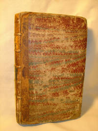
In original binding of marbled paper in Dutch double comb pattern of red and blue over boards, backed with leather; black spine panels with gilt stamped titles; 5 raised bands. Heavily rubbed on covers and spine; worn to boards at cover edges and corners; spine leather worn/deteriorated, raised bands exposed; covers fragile but still attached; text block tightly bound; 19th century bookplate on front pastedown; contemporary owner name in black ink (King?) on title page at top edge; interior supple and clean. Note that title page gives 'Part I for 1776' and index is for 'Volume II' but clearly relates to this volume. Covers many events in all colonies. Included: Ethan Allen's capture; Benedict Arnold's march on Quebec; an early version of the Articles of Confederation as submitted to North Carolina Assembly (rejected); Virginia Committee of Safety Resolution appointing Patrick Henry Commander in Chief of VA forces; Ben Franklin's correspondence to British friend expressing impossibility of British…
Read More La Géographie du temps by Du Val, Pierre - 1682: Qui fait voir l’estat present des IV. Parties du monde, C’est à dire, les religions, les coutumes & les Richesses des Peuples : Les Forces & les Gouvernemens des Estats : Ce qui est de plus beau & de plus rare dans chaque Region : Et autres particula
by Du Val, Pierre

La Géographie du temps: Qui fait voir l’estat present des IV. Parties du monde, C’est à dire, les religions, les coutumes & les Richesses des Peuples : Les Forces & les Gouvernemens des Estats : Ce qui est de plus beau & de plus rare dans chaque Region : Et autres particula
by Du Val, Pierre
- Used
- very good
- first
Very good. Decorated gilt back with 5 raised bands, red morocco label, gilt dentelles, marbled edges. Gilt and hand-coloured title pages. Complete text, 312 pp. and 51 hand-coloured maps and 10 hand-coloured and occasionally silver/gilt blazons / coats-of-arms. Vol. 1 of 2. Includes the famous map of California shown as an island. Normal wear to corners and edges. Discrete ex libris. Contemporary very small initials on first two pages. Occasional toning/staining to leaves, but generally clean, and does not affect illustrations.
-
Bookseller
Independent bookstores
 (SE)
(SE)
- Illustrator Du Val, Pierre
- Format/Binding Contemporary calf.
- Book Condition Used - Very Good
- Quantity Available 1
- Publisher L’auteur, Nicolas Langlois.
- Place of Publication Paris
- Date Published 1682
- Size 12mo
- Size 12mo
More Photos
The Remembrancer; or, Impartial Repository of Public Events. Part I for the Year 1776
by J. Almon (ed)
- Used
- good
- Hardcover
- Condition
- Used - Good
- Binding
- Hardcover
- Quantity Available
- 1
- Seller
-
Brattleboro, Vermont, United States
- Item Price
-
A$2,597.09
Show Details
Item Price
A$2,597.09

More Photos
An Ephemerides of the Coelestial Motions for XIII Years Beginning Anno 1659. Ending Anno 1671 . . . .
by Wing, Vincent (Vincentio Wingo)
- Used
- Hardcover
- Condition
- Used
- Binding
- Hardcover
- Quantity Available
- 1
- Seller
-
Datil, New Mexico, United States
- Item Price
-
A$2,635.85
Show Details
Description:
London: Printed by R. & W. Leybourn, for the Company of STATIONERS, 1658. Hardcover, size 7.5"x5.5". Full calf with four raised bands. [xxii], 148, [viii] pages, plus the 13 ephemerides which vary from approximately 28 to 36 pages each, plus a final leaf of errata. The ephemerides themselves were previously printed separately - seven are dtd 1656, five are dtd 1657, and one for the year 1669 is dtd 1669 (clearly a misprint). Condition of the casing is Good- (minus): considerable wear, abbreviated title inked on spine label. Condition of the text is Good: occasional light soiling/foxing or marginal chip/closed tear; text rippled from aging. Previous owner's stamp on endpapers, title page, and three places in text; armorial bookplate of John Earl of Loudoun w/double-headed eagle & motto "I Bide My Time" on front pastedown..
Item Price
A$2,635.85

More Photos
Travels in the Interior Districts of Africa: Performed under the direction and patronage of the african association, in the years 1795, 1796, and 1797. with an appendix, containing illustrations of Africa by Major Rennel
by PARK, Mungo
- Used
- very good
- Hardcover
- Condition
- Used - Very Good
- Edition
- 2nd
- Binding
- Hardcover
- Quantity Available
- 1
- Seller
-
Cuernavaca, Mexico
- Item Price
-
A$2,465.30
Show Details
Description:
London, W.Bulmer and Co., 17994º. xxviii,(2),372 pp., xcii. Bound to style in a fine later calf. Title-and tomelabels with gilt lettering. Blindtoolings to bands and compartments of spine. Engraved portrait as frontispiece, 2 engraved plates with music, 5 engraved plates (of which 3 are views) and 3 large folded engraved maps. One map strenghtened in foldings and edges, one map with a closed tear to folding. Wide-margined, a few margins slightly brownspotted. Light offsetting to title and portrait.
Second edition - the same year as the first - of this classic work of travel litterature.
"Until the publicationof Park's book in 1799 hardly anything was known of the interior of Africa, apart from the north-east region and coastal areas....the real opening up of Africa by the white races began with the African Association, founded in 1788 with the express purpose of exploring Africa and furthering British tradee and political influence onthe continent...Parks travels had an immediate success and was… Read More
Item Price
A$2,465.30
More Photos
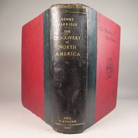
The Discovery of North America, A Critical, Documentary, and Historic Investigation,: with an essay on the early cartography of the New World, including descriptions of two hundred and fifty maps or globes existing or lost, constructed before the year 1536...
by Henry Harrisse
- Used
- very good
- Hardcover
- first
- Condition
- Used - Very Good
- Edition
- First Edition
- Binding
- Hardcover
- Quantity Available
- 1
- Seller
-
Fort Lauderdale, Florida, United States
- Item Price
-
A$2,248.22
Show Details
Description:
Quarter morocco over pictorial maroon cloth board with gilt particulars to spine. Top edge gilt. Limited edition copy No. 91 of 380 issued, this being the English Toned Paper edition. Hors textes plates with tissue guards throughout. Black and white illustrations throughout text as well. Title continued: "to which are added a chronology of one hundred voyages westward, projected, attempted, or accomplished between 1431 and 1504; biographical accounts of the three hundred pilots who first crossed the Atlantic; and a copious list of the original names of American regions, caciqueships, mountains, islands, capes, gulfs, rivers, towns, and harbours." Topics include: John Cabot, Gaspar Corte-Real, Christopher Columbus, Ancient Maps, First Knowledge of Florida, Colonisation [colonization] of Nova Scotia, Aliminos, Pardon Real, Lusitano-Germanic Cartography, and much more. Wear to head of spine and hinges, but still intact and sturdy. 802 pp. 9 3/4 x 11 3/4. A clean, bright volume without previous owners'…
Read More Item Price
A$2,248.22

More Photos
Opus Geomantiae Completum in Libros Tres Divisum: Quorum I. Universam Geomanticam Theoriam, II. Praxim, III. Varias a diversis authorib, decerptas questions co[n]tinet.
by Henricus de Pisis.
- Used
- Condition
- Used
- Edition
- Second
- Quantity Available
- 1
- Seller
-
Great Barrington, Massachusetts, United States
- Item Price
-
A$3,876.25
Show Details
Description:
Small 8vo. Bound in contemporary vellum. Printed by Jean Antoine Huguetan, Lyons 1638. (Colophon at end dated 1627; printing privilege dated 1626.) Second Edition of this comprehensive treatise on geomancy.Illustrated with numerous diagrams, schematic woodcuts and tables in text, as well as 10 plates, 1 of which is an engraved single-page plate, while the other 9 are fold-out woodcut diagrams or letterpress tables, some bound to face each other; plus large engraved printer's device with an armillary sphere on title-page; a few decorative woodcut head-pieces and initials.The Opus Geomantiae Completum "is divided into three parts devoted respectively to the theory, practice and questions taken from previous authors. The theory is largely astrological. Instead of jotting down four rows of dots at random, a wheel with sixteen projections is spun or whirled in order to obtain one of the sixteen geomantic figures. Fludd is cited more than once, also Arabic authors like Geber and Aomar, medieval Latins like…
Read More Item Price
A$3,876.25

The island of Crete and the adjacent islands of the Aegean with the new island of Santorini ... "Insuls Creta nunc Candia in sua IV Territoria distinicta, cum aliqoud adjacentibus Ægei maris Insulis imprimis Nova Santorini insula modo ante XXVII annos ex abysso marsi emersa..." "Creta nunc Candia
by Lotter Conrad Tobias
- Used
- Condition
- Used
- Binding
- Unknown
- Quantity Available
- 1
- Seller
-
Nafplion, Greece
- Item Price
-
A$2,493.30
Show Details
Description:
Greece: Augsburg, Lotter Conrad Tobias 1772. Copper engraved map of Crete with View of Iraklion after Seutter from Lotters "Atlas Novus." . Original old colour; verso blank The map shows the island of Crete, taken from the Homann map of 1712 [ Zacharakis 1641/1879] with the a long text beside the newly emerged island at Santorini following the volcanic eruption of 25th May 1707: "In 1707, activity began again, the small when two cones appeared. They were called Aspronisi and Macronesi. Those were united in the course of the following five years by an island which formed between Palea and Small Kameni, much larger and higher then either and was called Nea (New) Kameni .This island, is the youngest island in Greece."[Santorini Living ] Below is a panaromic view of Iraklion, black & white as issued. The map was first published by Lotter's father-in-law Matthaüs Seutter in his "Atlas Novus" in 1728 who took the lower part of Homann's map re-engraved the cartouche and text and added the scale to the…
Read More Item Price
A$2,493.30

More Photos
Le nouveau et curieux Atlas Geographique et historique...
by Chiquet (Jacques) [Antoine Menard].
- Used
- Hardcover
- Condition
- Used
- Binding
- Hardcover
- Quantity Available
- 1
- Seller
-
Sidney, British Columbia, Canada
- Item Price
-
A$3,488.62
Show Details
Description:
Paris: chez Chereanau, [1719].. Oblong small 4to. Full vellum with ties. Wear at edges, chip from fore-edge of lower front cover,blank end leaves are heavily annotated and written-upon in 18th & 19th century hands. Old stains to margins and a few maps, old paper-tape repairs to the verso of the Asia map, but generally very good. Engraved allegorical title page, 3 plates (two of globes), and 24 maps opposite explanatory text in French. 23 maps have contemporary hand-colouring in outline; a couple have attractively coloured cartouches. The Globe Terrestre map, of two hemispheres, is holed, slightly affecting the title. The map of North America shows California as an island. This is the second or third edition of this atlas, originally by Antoine Menard, first published by Chiquet in [1711 & 1713], with most of the maps dated 1709-1711. In this 1719 edition Chiquet has removed Menard's name entirely; on many of the maps (such as L'Amerique Septentrionale) he has changed it to his own name and altered…
Read More Item Price
A$3,488.62

More Photos
Account of an Expedition from Pittsburgh to the Rocky Mountains, Performed in the Years 1819, and '20, by Order of The Hon. J. C. Calhoun, Sec'y of War: Under the Command of Major Stephen H. Long. From the Notes of Major Long, Mr. T. Say, and Other Gentlemen of the Exploring Party. (in two volumes)
by JAMES, Edwin
- Used
- Hardcover
- first
- Condition
- Used - Very Good+
- Binding
- Hardcover
- Quantity Available
- 1
- Seller
-
Littleton, Colorado, United States
- Item Price
-
A$2,945.95
Show Details
Description:
Philadelphia: H. C. Carey and I. Lea. Very Good+. 1823. Hardcover. A two-volume first edition of an account of the Long Expedition to the Rocky Mountains by expedition botanist and geologist Edwin James. Compiled from the notes of Major Stephen H. Long, Mr. T. Say, and other gentlemen of the party by Mr. James. This rather scarce set presents the account of the experiences of the Stephen H. Long expedition of 1819-1820, in which Long was sent to find the source of the Platte River in the Rocky Mountains. Lacks the separate accompanying oversize atlas which was issued in 1822 per Howes J.41, who remarks [the expedition was notable in that it supplemented] ". . .earlier discoveries of Pike and of Lewis and Clark, and pronouncing the plains region as nothing but a desert, incapable of cultivation!". --- In maroon half leather and marbled paper-covered boards with gilt-stamped spine titling, four raised bands to spines and marbled endpapers. --- A very nice set, with bright, mostly…
Read More Item Price
A$2,945.95

More Photos
Judgement Worthy of God, or an Assertion of the Existence and Duration of Hell Torments, in Two Occasional Letters, Written Several Years Since.To which is Added an Accordance of St. Paul, with St. James, in the Great Point of Faith and Works
by Hammond, Henry. 1605-1660
- Used
- near fine
- Hardcover
- Condition
- Used - Near Fine
- Jacket Condition
- No Jacket
- Binding
- Hardcover
- Quantity Available
- 1
- Seller
-
Whitby, Ontario, Canada
- Item Price
-
A$2,551.27
Show Details
Description:
Oxford: Printed by H.H., Printer to the University, for Ric Royston and Ric Davis, 1665. Hardcover. Near Fine/No Jacket. 32mo. Calf. [23] 155 p.p. Bumping to corners. Spine tilted. Wear and scratches to spine. Hinges bound tightly. Note in iron gall ink on leaf facing title page: "this Henry Hammond is thought to be the author of Whole Duty of Man.' The Whole Duty of Man is a Protestant devotional book that was published anonymously, with an introduction by Henry Hammond, though authorship was later attributed to Richard Allestree [1621-1681]. Henry Hammond [1605-1660] was a churchman, preacher, and Royalist sympathizer during the English Civil War. As a theologian, he produced several sermons and religious tracts, and compared texts of the New Testament in his book, "Paraphrase and Annotations Upon all the Books of the New Testament" [1653].
Item Price
A$2,551.27

More Photos
1696 Sacrarum Religionum Picinelli Augustinus Augustinian Order Religion Canon
by Filippo Picinelli, Augustinus Erath
- Used
- first
- Condition
- Used - Good-
- Quantity Available
- 1
- Seller
-
Providence, Seychelles
- Item Price
-
A$3,372.34
Show Details
Description:
Sacrarum Religionum Maximae Ex Regula S. P. N. Augustini Ecclesiae Doctoris Maximi Filippo Picinelli, Augustinus Erath (The divine sanctity of religion from the dogmas compiled by S.P.N. Augustini, Doctor of the Church) – In Latin language.***
1st edition Königsberg, Augustae Vindelicorum, 1696.
***
Pp: /20/ + 324 + /16/ with copper plate Size: 19 x 16 cm.
***
Binding: Original leather binding. Damaged spine extremes, bumped edges. Panels slightly damaged signs of wear and aging (visible on scans), clamps missing, cracked spine joints. Condition: Signature by previous owner on the flyleaf. Foxing. Paper browning, signs of use.
Item Price
A$3,372.34

Let's Meet up ! - Anglais 2de Éd. 2019 - Livre élève
by Erwan Gouraud, Amal Navailh, Isabelle Valentin, Fatima Zaâzoui, Axel Jacobin, Bryce Angot, Hugues Azais, Mélanie Cubertafond, Elodie Davo-verdavoir, Véronique Dorget, Sylvie Douglade-Val, Françoise Du et Pierre Guendouz
- Used
- very good
- Paperback
- Condition
- Used - Very Good
- Binding
- Paperback
- ISBN 10 / ISBN 13
- 9782401053199 / 2401053190
- Quantity Available
- 1
- Seller
-
Morangis, France
- Item Price
-
A$7.75
Show Details
Description:
Hatier, 2019. Paperback. Very Good. Slight signs of wear on the cover. Edition 2019. Ammareal gives back up to 15% of this item's net price to charity organizations.
Item Price
A$7.75

Notre-Dame-du Val-de-Grâce
by LEFEBVRE Pierre (1923-2009) Médecin général inspecteur Directeur de l'École du Val de Grâce - Lettre-Préface du Père Carré
- Used
- Condition
- Used - Très bon état
- ISBN 10 / ISBN 13
- 9782902474721 / 2902474725
- Quantity Available
- 1
- Seller
-
isle sur la sorgue, France
- Item Price
-
A$11.64
Show Details
Description:
in8. 1991. cartonné.
Item Price
A$11.64
Let's Meet up ! - Anglais 2de Éd. 2018 - Livre élève
by Erwan Gouraud, Hugues Azaïs, Véronique Dorget, Sylvie Douglade-Val, Françoise Du, Pierre Guendouz, Axel Jacobin, Isabelle Valentin et Fatima ZAÂZOUI
- Used
- good
- Paperback
- Condition
- Used - Good
- Binding
- Paperback
- ISBN 10 / ISBN 13
- 9782401046214 / 2401046216
- Quantity Available
- 1
- Seller
-
Morangis, France
- Item Price
-
A$10.48
Show Details
Description:
Hatier, 2018. Paperback. Good. Slight signs of wear on the cover. Edition 2018. Ammareal gives back up to 15% of this book's net price to charity organizations.
Item Price
A$10.48
Let's Meet up ! - Anglais 2de Éd. 2018 - Livre élève
by Erwan Gouraud, Hugues Azaïs, Véronique Dorget, Sylvie Douglade-Val, Françoise Du, Pierre Guendouz, Axel Jacobin, Isabelle Valentin et Fatima ZAÂZOUI
- Used
- very good
- Paperback
- Condition
- Used - Very Good
- Binding
- Paperback
- ISBN 10 / ISBN 13
- 9782401046214 / 2401046216
- Quantity Available
- 1
- Seller
-
Morangis, France
- Item Price
-
A$11.44
Show Details
Description:
Hatier, 2018. Paperback. Very Good. Edition 2018. Ammareal gives back up to 15% of this book's net price to charity organizations.
Item Price
A$11.44

Stock Photo: Cover May Be Different
Théâtre Mystique De Pierre Du Val: Et Des Libertins Spirituels De Rouen, Au Xvie Siècle (French Edition)
by Pierre Du Val
- Used
- good
- Paperback
- Condition
- Used - Good
- Binding
- Paperback
- ISBN 10 / ISBN 13
- 9781144838995 / 1144838991
- Quantity Available
- 1
- Seller
-
HOUSTON, Texas, United States
- Item Price
-
A$53.90
Show Details
Description:
Nabu Press, 2010-02-22. Paperback. Good.
Item Price
A$53.90
Theatre Mystique De Pierre Du Val et Des Libertins Spirituels De Rouen Au XVIe Siecle....introduction Par Emile Picot.
by Du Val. Pierre
- Used
- very good
- Hardcover
- Condition
- Used - Very Good
- Jacket Condition
- No Jacket
- Edition
- Reprint
- Binding
- Hardcover
- Quantity Available
- 1
- Seller
-
Carmarthenshire, United Kingdom
- Item Price
-
A$34.92
Show Details
Description:
Geneve: Slatkine, 1969. Reprint . Hardcover. Very Good/No Jacket. 8vo - over 7¾" - 9¾" tall. original cloth hardcover, 252 pages, ex reference library with the usual marks, otherwise very good clean and complete.
Item Price
A$34.92

Stock Photo: Cover May Be Different
Théâtre Mystique de Pierre Du Val: Et des Libertins Spirituels de Rouen, Au XVIe Siècle (French Edition)
by Emile Picot Pierre Du Val
- Used
- Paperback
- Condition
- Used:Good
- Binding
- Paperback
- ISBN 10 / ISBN 13
- 9781103602216 / 1103602217
- Quantity Available
- 1
- Seller
-
HOUSTON, Texas, United States
- Item Price
-
A$66.11
Show Details
Description:
BiblioLife, 2009-03-19. Paperback. Used:Good.
Item Price
A$66.11

Stock Photo: Cover May Be Different
Théâtre Mystique de Pierre Du Val: Et des Libertins Spirituels de Rouen, Au XVIe Siècle (French Edition)
by Emile Picot Pierre Du Val
- Used
- Hardcover
- Condition
- Used:Good
- Binding
- Hardcover
- ISBN 10 / ISBN 13
- 9781103602254 / 110360225X
- Quantity Available
- 1
- Seller
-
HOUSTON, Texas, United States
- Item Price
-
A$78.08
Show Details
Description:
BiblioLife, 2009-03-19. Hardcover. Used:Good.
Item Price
A$78.08
Picardie
by Du Val, Pierre:
- Used
- Condition
- Used
- Quantity Available
- 1
- Seller
-
London, United Kingdom
- Item Price
-
A$77.60
Show Details
Description:
Paris, 1667. Copper engraving, 10.5 x 12.6 cms, original hand-colour, lightly browned, blank verso; leaf from the same work, with the arms of Ponthieu, pasted to the right hand edge. Map
Item Price
A$77.60
Anglais 1�re B1-B2 Let's Meet up !
by Gouraud, Erwan/ Navailh, Amal/ Valentin, Isabelle/ ZA�ZOUI, Fatima/ Jacobin, Axel/ Angot, Bryce/ Azais, Hugues/ Cubertafond, M�lanie/ Davo-verdavoir, Elodie/ Dorget, V�ronique/ Douglade-Val, Sylvie/ Du, Fran�oise/ Guendouz, Pierre
- New
- Paperback
- Condition
- New
- Binding
- Paperback
- ISBN 10 / ISBN 13
- 9782401052987 / 2401052984
- Quantity Available
- 1
- Seller
-
Exeter, Devon, United Kingdom
- Item Price
-
A$86.82
Show Details
Description:
Hatier, 2019. Paperback. New. 304 pages. French language. 10.94x7.64x0.63 inches.
Item Price
A$86.82

More Photos
The Sky and the Forest
by Forester, C.S
- Used
- very good
- Hardcover
- first
- Condition
- Used - Very Good
- Jacket Condition
- Very Good
- Edition
- First Edition
- Binding
- Hardcover
- Quantity Available
- 1
- Seller
-
Salem, Oregon, United States
- Item Price
-
A$54.10A$32.45Save A$13.96!
Show Details
Description:
C.S. Forester: The Sky and the Forest. Little, Brown and Company, Boston. Stated First Edition First Printing Thus August, 1948. Cover price $2.75. Used. VG BOOK/VG UNCLIPPED DUST JACKET. A story of a central Africa. By C.S. Forester, author of the Admiral Hornblower series.
Item Price
A$54.10A$32.45
Save A$13.96
!
![Alaska and Klondike Region; [With inset of Klondike Region on the Upper Yukon detail] [From an...](https://d3525k1ryd2155.cloudfront.net/h/062/537/1339537062.0.m.jpg)
Alaska and Klondike Region; [With inset of Klondike Region on the Upper Yukon detail] [From an atlas, "Gazetteer of Alaska and Yukon Region " pp. 105 and 106]
by Miller, J. Martin
- Used
- very good
- Condition
- Used - Very Good
- Edition
- Unknown
- Quantity Available
- 1
- Seller
-
Sebastopol, California, United States
- Item Price
-
A$60.47
Show Details
Description:
Chicago: J. Martin Miller, 1899. Unknown. Map. Very Good. [Map copyright 1899, printing date of Atlas later] [19.875x15.125in]; Colored map of Alaska with steamer routes from Portland and Seattle, insets of the Klondike Region on the Upper Yukon and Western portion of Aleutian Islands; On verso index of places and names with two large black and white images; Age toning to all edges, water stain marks on bottom, slight printing offset of colors, small chips and closed tears to lower edge;.
Item Price
A$60.47

Zemepis Sveta - Monsunova Asie
by De La Blache, P. Vidal; Gallois, L
- Used
- Hardcover
- Condition
- Used - Very Good Condition
- Jacket Condition
- No Dust Jacket
- Binding
- Hardcover
- Quantity Available
- 1
- Seller
-
Oak Point, Texas, United States
- Item Price
-
A$93.03
Show Details
Description:
Aventinum, Prague, Czechoslovakia, 1931. Hardcover. Very Good Condition/No Dust Jacket. Text entirely in Czech. Geography book on Asia with numerous photographs and maps. 1930 edition also available. Size: 4mo - over 9 3/4" - 12" tall. 400 pp. Pages are yellowed, but are tight and clean. Moderate shelfwear along the spine. Corners are lightly bumped. Quantity Available: 1. Shipped Weight: 3-5 pounds. Category: Travel & Places; Non-English Language::Czech; Pictures of this item not already displayed here available upon request. Inventory No: 001228. . Additional shipping charges may apply.
Item Price
A$93.03

Zemepis Sveta - Monsunova Asie
by De La Blache, P. Vidal; Gallois, L
- Used
- Hardcover
- Condition
- Used - Very Good Condition
- Jacket Condition
- No Dust Jacket
- Binding
- Hardcover
- Quantity Available
- 1
- Seller
-
Oak Point, Texas, United States
- Item Price
-
A$93.03
Show Details
Description:
Aventinum, Prague, Czechoslovakia, 1930. Hardcover. Very Good Condition/No Dust Jacket. Text entirely in Czech. Geography book on Asia with numerous photographs and maps. 1931 edition also available. Size: 4mo - over 9 3/4" - 12" tall. 400 pp. Pages are yellowed, but are tight and clean. Moderate shelfwear along the spine. Corners are lightly bumped. Quantity Available: 1. Shipped Weight: 3-5 pounds. Category: Travel & Places; Non-English Language::Czech; Pictures of this item not already displayed here available upon request. Inventory No: 001227. . Additional shipping charges may apply.
Item Price
A$93.03

North America from the Best Authorities, Russell, ca.1800
by Russell
- Used
- Condition
- Used
- Quantity Available
- 1
- Seller
-
Plymouth, Devon, United Kingdom
- Item Price
-
A$38.80
Show Details
Description:
Russell, J. : A General Map of North America from the Best Authorities. Nd but ca.1800. From "A New Geographical, Historical and Commercial Grammar and Present State of Several Kingdoms of the World." Copper engraving. Size approx 200 x 230mm. Two neat folds. Some age colouring to edges, otherwise very clean and bright.
Item Price
A$38.80

Asia from the Best Authorities, Russell, ca.1800
by Russell
- Used
- Condition
- Used
- Quantity Available
- 1
- Seller
-
Plymouth, Devon, United Kingdom
- Item Price
-
A$38.80
Show Details
Description:
Russell, J. : Asia from the Best Authorities. Nd but ca.1800. From "A New Geographical, Historical and Commercial Grammar and Present State of Several Kingdoms of the World". Copper engraving. Size approx 200 x 230mm. Two neat folds. Some age colouring to edges, otherwise clean and bright. Includes Arabia, India, Borneo, Japan, China and eastern Russia.
Item Price
A$38.80
![MAP OF UTAH [Territory]](https://d3525k1ryd2155.cloudfront.net/h/836/461/1485461836.0.m.jpg)
More Photos
MAP OF UTAH [Territory]
- Used
- Condition
- Used - Very Good-
- Edition
- Original
- Quantity Available
- 1
- Seller
-
Williamsburg, Virginia, United States
- Item Price
-
A$100.78
Show Details
Description:
New York, Richmond, Chicago, & Toledo: H. H. Hardesty, 1885. Original color lithographed map printed by Rand, McNally & Company, Engravers and published in HARDESTY'S HISTORICAL AND GEOGRAPHICAL ENCYCLOPEDIA: SPECIAL VIRGINIA EDITION. 19 3/8 inches by 13 1/4 inches on a 21" X 14 1/2" sheet. The map depicts the Territory of Utah in its final form--large areas had been removed and ceded to Nevada, Colorado, Wyoming, and Nebraska since Utah became a U. S. Territory in 1850. The issue of polygamy prevented statehood until it was finally granted in 1896. This map features railroads and topography and uses color to set off counties from each other. Unlike most atlas maps of the period, this map identifies most small towns. The map is guaranteed to be moe than 135 years old. The map is in about very good condition: generally clean and bright, with slight toning of paper and one faint water stain near the center-left edge of the map.. Original. Single Sheet. Very Good-. Elephant…
Read More Item Price
A$100.78

Philips Special Map of the Nile, The Advance on Khartum and the Environs of Omdurman. Cc1900
by George Philips and Son,
- Used
- Condition
- Used
- Quantity Available
- 1
- Seller
-
Plymouth, Devon, United Kingdom
- Item Price
-
A$50.44
Show Details
Description:
Philips Special map of the Nile illustrating the Advance on Khartum [Khartoum] with an enlargement of the environs of Omdurman [Omdur]. George Philips and Son, London and Liverpool Ca 1900. 580mm x 900mm folded map. Front title wrapper has come loose, not affecting map area. Three maps are displayed within the sheet. Map1. Map of the Nile Valley 520mm x 300mm showing the approaches of Khartum. Scale 1inch to 100 Geographical miles. Coloured indicating Possessions and Protectorates of European Powers. Map 2. Special map of the Nile from Dongola to Khartum. Scale 16 miles to the inch. Coloured. In set in this map is Map3. Environs of Omdurman, Scale 5 statute miles to the inch. Some small breaks at some folds, not affecting imagery or use of map. Title label is damaged, the map is clean and bright, probably unused. A very interesting record.
Item Price
A$50.44

Last Tales
by Dinesen, Isak
- Used
- very good
- Hardcover
- first
- Condition
- Used - Very Good
- Jacket Condition
- Good+
- Edition
- First Edition
- Binding
- Hardcover
- Quantity Available
- 1
- Seller
-
Salem, Oregon, United States
- Item Price
-
A$186.06A$111.64Save A$48.00!
Show Details
Description:
Dinesen, Isak: Last Tales, A Collection of Twelve New Tales of Compelling Beauty 1957, Random House. First Edition. Stated First Printing Thus. Used. Very Good/Good+ original red dust jacket, price-clipped. Jacket states 11/57 on front flap. 5 3/4 X
Item Price
A$186.06A$111.64
Save A$48.00
!

The Adventure of Wrangel Island
by Vilhjalmur Stefansson
- Used
- good
- Hardcover
- first
- Condition
- Used - Good
- Jacket Condition
- No DJ Included
- Edition
- First Edition
- Binding
- Hardcover
- Quantity Available
- 1
- Seller
-
Salem, Oregon, United States
- Item Price
-
A$193.64A$116.18Save A$49.96!
Show Details
Description:
The Adventure of Wrangel Island, Alaska (1925 Macmillan 1st Edition) HISTORY OF ALASKA. EXLIB. Good Condition/ No DJ included. Fold-out map affixed to binding at the back of the book has never been opened. The story of the (unsuccessful) attempted colonization of Wrangel Island Alaska. 413 pages plus appendix, Index. Titling is still bright. A clean, solid copy. Scarce.
Item Price
A$193.64A$116.18
Save A$49.96
!
