Description:
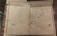
Paris, 1739. Folio. (21 5/8 x 17 1/2 inches). Folding index map and very large perspective plan on 20 sheets by Claude Lucas after Louis Bretez, sheets 18 and 19 joined as issued, decorative engraved border with fleur-de-lys cornerpieces, title in elaborate figural cartouche. Contemporary calf, Boards with gilt, borders fleur-de-lys at corners, gilt Arms of Paris on front board, spine gilt in compartments, gilt edges, red morocco labels, marble endpapers. A First Copy of the First edition of the monumental Turgot plan of Paris: a cartographical tour-de-force. The best 18th-century plan of Paris, and among the most impressive of all city plans. The 20 sheets of this impressive atlas form a single enormous plan, which when joined would be approximately 8.25 x 10.5 feet. The map covers an area approximately corresponding to the first eleven of the modern-day arrondissements and is the best 18th century plan of Paris. In 1734, Michel-Étienne Turgot, chief of the municipality of Paris, in order to…
Read More Plan de Paris, commence l'annee 1734. Acheve de Graveur en 1739 by TURGOT, Michel-Etienne, Marquis de Sousmons (1690-1751)
by TURGOT, Michel-Etienne, Marquis de Sousmons (1690-1751)
Plan de Paris, commence l'annee 1734. Acheve de Graveur en 1739
by TURGOT, Michel-Etienne, Marquis de Sousmons (1690-1751)
- Used
- Hardcover
[Paris: 1739 or 1740]. Folio (22 x 17 4/8 inches). Fine folding engraved key map, and 20 double-page engraved sheets that combine to make one exceptionally large plan of Paris (ca 98 inches x 127 inches) by Claude Lucas after Louis Bretez (sheets 18 and 19, with the title cartouche, joined and folding) (a bit browned throughout). Contemporary red morocco gilt, each cover decorated with broad gilt borders of fleur-de-lis and palm frond roll tools, with large fleur-de-lis at each inner corner, and with a fine central gilt medallion of the arms of the city of Paris, the spine in ten compartments with nine raised bands, red morocco lettering-piece in one, the others decorated with fine gilt tools, all edges gilt (rebacked preserving most of the original spine, some restoration to corners). Provenance: with the ownership inscription of “Pen: Wyndham” (Henry Penruddocke Wyndham, (1736–1819)), topographer on the verso of the front free endpaper. A MAGNIFICENT AND DETAILED PLAN OF PARIS: AN ISOMETRIC PERSPECTIVE FROM THE SOUTHEAST COMPOSED OF 20 SEPARATE ENGRAVED SHEETS. The area covered by this extraordinary map includes roughly the first eleven arrondissements of modern Paris, and is a fine and beautiful representation of the capital before the transformation made to the city by Napoleon III and Haussmann. At the time of this survey France, and so Paris, was effectively being ruled, with King Louis XV’s assent, by Cardinal de Fleury. From 1726 until Fleury’s death in 1743 was the most peaceful and prosperous part of the reign of Louis XV. After the financial turmoil and human suffering at the end of the reign of Louis XIV, the rule of Fleury is seen by many historians as a period of recovery. He stabilized the French currency, balanced the budget, and made economic expansion a central goal of the government. Communications were improved with the completion of the Saint-Quentin canal (linking the Oise and Somme rivers) in 1738, later extended to the Escaut River and the Low Countries and the systematic building of a national road network. By the middle of the 18th century, France had the most modern and extensive road network in the world. In this map, avenues, streets, and individual buildings, gardens, lumber and boatyards are all shown with exquisite accuracy, as the official surveyor, Louis Bretez, was given carte blanche to enter private property to record the finest details between 1734 and 1736. He was commissioned by Turgot, as the then head of the Paris municipality, to create this stunning image of Paris, to promote to the great and the good at home and abroad. Bretez, was a member of the Academy of Painting and Sculpture and a teacher of perspective. Claude Lucas, a member of the Academy of Sciences, engraved the plates in 1836. In 1739 the prints were bound in volumes presented to the King, members of the Academy, the Municipality, and French envoys abroad, to promote the beauty and magnificence of Paris. From the distinguished library of Pen Wyndham, who as a young man travelled extensively in Europe: “with his relation Joseph Wyndham, and William Benson Earle of Salisbury, Wyndham set out on the grand tour in 1765. Theirs was not the usual party of very young men with a tutor. Pen Wyndham was by this time twenty-nine and had already demonstrated some learning as an antiquary. After leaving England in September, the party visited France, Italy, and Sicily, and returned via Geneva and the Netherlands to reach England in September 1767. Pen Wyndham's letters to his father (now in the Wiltshire and Swindon Record Office, Trowbridge) show him very critical of much of what he saw. As well as the normal litany of complaints about the inns, food, and predations of the local people, he showed the family whig traits by complaining about the despotic rulers of the lands he passed through, and compared the poverty and ignorance of their people with the happy freedoms of the British. He enjoyed seeing John Wilkes at Dijon and was in Rome at the time of James Stuart's funeral, noting with pleasure that the pope did not accord him the dignity of a king. Wyndham's reaction to the sights of Europe was also mixed. Having found Versailles ‘quite disgusting’ and the cathedral of Siena ‘rather gawdy’ (cited in Wyndham, A Family History, 192, 198), he drew more pleasure from the Roman antiquities. He went home unmoved by much of what he had seen, and convinced that English life and manners were superior in many respects” (Elizabeth Baigent for DNB). Brunet I:1224 (giving the date of publication as 1740); Cohen-de Ricci 807..
-
Bookseller
Arader Galleries
 (US)
(US)
- Book Condition Used
- Binding Hardcover
- Publisher [Paris: 1739 or 1740].

More Photos
Plan de Paris, Commencé l'Année 1734. Dessiné et Gravé, sous les ordres de Messire Michel Etienne Turgot ... Achevé de Graver en 1739 ..
by TURGOT, Michel Etienne, Marquis de Sousmons (1690-1751); and Louis BRETEZ
- Used
- Condition
- Used
- Quantity Available
- 1
- Seller
-
New York, New York, United States
- Item Price
-
A$37,922.40
Show Details
Item Price
A$37,922.40