Click for full-size.


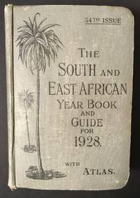
The South and East African Year Book Guide. With Atlas and Diagrams. 34th Issue owned by A. Jessop: Union-Castle Atlas pp. 2-64 with color maps, single and double page, George Philips & Son, Geographical Institute, London
by Edited Annually By A. Samler Brown, F.R.M.S. & G. Gordon Brown, F.R.G.S
- Used
- Hardcover
- Signed
- Condition
- See description
- Seller
-
FRAMINGHAM, Massachusetts, United States
Payment Methods Accepted
About This Item
Contents and Condition:
Union-Castle Atlas pp. 2-64 with color maps, single and double page, George Philips & Son, Geographical Institute, London
Union-Castle Atlas pp. 2-64 with color maps, single and double page, George Philips & Son, Geographical Institute, London
"Advertisements South Africa, Capetown with East Africa Route", pp. 1-129.
dimensions: 7 3/8" x 5 1/2" x 1 5/8"
condition: decorated fabric covers show mild wear, binding tight, front cover attached with weakening at bottom of binding
owner's name in manuscript ink on title page: "A.Jessop Coronado, California, U.S.A"
Description:This densely informative travel guide was owned by A. Jessop of Coronado, California. The A. Jessop who owned this book is most likely a son of Joseph Edward Jessop, an English watchmaker and jewelry store owner who with his wife emigrated from London, England to California, seeking to settle in the San Diego area with their children. The Jessop family established a jewelry store that became multi-generational in the San Diego, California area. In 1901 the Jessop family moved to Coronado, California. In 1907, Mr. Jessop introduced a street clock with his name on it to Coronado. That clock became a city fixture in San Diego. It stood 22 feet high with its works 12 below ground. This historic and magnificent tall clock is currently in storage, and one hopes will be given an appropriate location in the San Diego area. Two sons have first names beginning with "A", Alonzo and Armand either of whom therefore could have owned this South and East Africa Year Book Guide of 1928. They were active in Coronado, California as citizens, businessmen in the jewelry trade and philanthropies.
The Year Book Guide of 1928 presents to the traveler a profile of South Africa and East Africa as of 1928, including geography, climate, natural resources such as diamonds, animal life, essentials for travelers including Game Laws and lists of animals available to be killed. The text advises "In no part of South Africa does a license give the right to shoot over private property." The South and East African Year Book Guide also provides routes over land and water, a sea voyage to Zanzibar and trips down the White Nile and Zambesi River. The detailed and colorful maps are prepared by George Philips & Son and published by the Geographical Institute, London. There are maps of South Africa and East Africa with steamship routes from Europe to and around Africa particularly appropriate as this book is also a promotional piece for the Upper-Castle Steamship Company, Limited. The guide notably describes mining activity in South Africa, including then current mining regulations. South Africa was, as it is today, a major gold producer.
As of 1928 when this Year Book Guide was published, South Africa and the other South African states were a self-governing Union in the British Empire but not a sovereign nation until 1934. The British influence in this 1928 Year Book Guide is evident in the numerous advertisements for London businesses at the front of the book, as well as the products listed for sale in the advertisements at the back of the book. In 1928, South Africa had a thriving economy in addition to being one of the world's major gold producers. Ironically, an international trip to South Africa in 1928, one year before the Great Depression hit the United States and created international financial disruption, was thus an extraordinary last hurrah in the first third of the 20th century. Perhaps the book's owner, Mr. A. Jessop made that trip as a holiday or for business and retained the Year Book Guide of 1928 as his souvenir.
Reviews
(Log in or Create an Account first!)
Details
- Bookseller
- Original Antique Maps
 (US)
(US)
- Bookseller's Inventory #
- 104
- Title
- The South and East African Year Book Guide. With Atlas and Diagrams. 34th Issue owned by A. Jessop
- Author
- Edited Annually By A. Samler Brown, F.R.M.S. & G. Gordon Brown, F.R.G.S
- Format/Binding
- Cloth over illustrated boards
- Book Condition
- Used
- Quantity Available
- 1
- Edition
- 34th
- Binding
- Hardcover
- Publisher
- Union-Castle Mail Steamship Company, Limited
- Place of Publication
- London
- Date Published
- 1928
- Weight
- 0.00 lbs
- Keywords
- South and East Africa maps, A. Jessop San Diego California, Jessop Jewelers Coronado, California, South Africa pre-statehood, South Africa mining, Colonial Africa 20th c.
Terms of Sale
Original Antique Maps
30 day return guarantee, with full refund including original shipping costs for up to 30 days after delivery if an item arrives misdescribed. If an item arrives damaged, please contact Original Antique Maps immediately to report the damage and discuss whether the original shipping materials may still be used to return the item and for return shipping instructions. Original Antique Maps will fully refund buyer's payments and pay for the return shipping of any damaged item. Buyer will be paid following receipt by Original Antique Maps of the returned item. Otherwise, returns as per www.spackantiquemaps.com.Buyer will be advised of shipping and handling charges that exceed standard charges to buyer.
About the Seller
Original Antique Maps
Biblio member since 2020
FRAMINGHAM, Massachusetts
About Original Antique Maps
Rare and unusual 18th and 19th century Americana, American and International maps, atlases, prints, nautical charts and manuscript maps. My interests include American 19th century newspapers and manuscript materials such as letters. Maps of the 20th c. including advertising, transit and urban planning are of special interest. Original art on paper in its many forms, including posters and field studies for ultimate print publication.
Glossary
Some terminology that may be used in this description includes:
- Tight
- Used to mean that the binding of a book has not been overly loosened by frequent use.
Frequently asked questions
This Book’s Categories

Collecting the 1939 New York World’s Fair
Born in the midst of the Great Depression, the theme of the 1939 World’s Fair was “The World of Tomorrow” - a theme that captured the hearts of a generation. Check out the maps, souvenirs, and other ephemera on Biblio!

A Brief History of the Dust Jacket
When did dust jackets first appear, and what exactly are they for? Learn about this often-important detail as it applies to book collecting. More...
Also Recommended
-
-
-

-
-

Save 10% on every purchase!
Join the Bibliophiles’ Club and start saving 10% on every book.
$29.95 / Year