Description:
Milwaukee: Silas Chapman, 1856. Colored folding map, 29 3/4 x 23 1/2 inches. Bound into original 16mo. brown cloth folder, gilt-lettered cover. Folder slightly worn and faded. Slight foxing on map. Colors on map generally bright and clean. Overall very good. A variant state of this important Minnesota map, without priority, published in as many as five versions in 1856. Many of the counties west of St. Paul are unidentified or shown in their earlier, larger incarnations, and the region along the north shore of Lake Superior is unmapped. This edition was published by Silas Chapman himself, who produced several pocket maps of Minnesota, Wisconsin, and Iowa. Chapman's maps were reproduced later by other publishers. While some 1856 versions of the map fail to show important geographic features shown here, such as Lake Minnetonka, the present map omits features that appear on other versions, such as the Sioux reservation in Goodhue and Wabasha counties and Houston county, indicating the present version is…
Read More Search Results: Pocket Maps from Donald Heald Rare Books
You searched for:
- Subject: Pocket Maps from Donald Heald Rare Books
Results 1 - 18 of 18

More Photos
Chapman's Sectional Map of Minnesota
by CHAPMAN, Silas (1813-1899)
- Used
- Condition
- Used
- Quantity Available
- 1
- Seller
-
New York, New York, United States
- Item Price
-
A$1,961.00FREE shipping to USA
Show Details
Item Price
A$1,961.00
FREE shipping to USA

More Photos
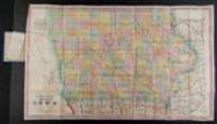
Chapman's Sectional Map of the State of Iowa Compiled from the United States Surveys and other authentic Sources
by IOWA - CHAPMAN, Silas (1813-1899)
- Used
- Condition
- Used
- Quantity Available
- 1
- Seller
-
New York, New York, United States
- Item Price
-
A$941.28FREE shipping to USA
Show Details
Description:
Milwaukee: Dyer & Pasmore, 1857. Folding pocket map, full period hand-colouring. Folds into publisher's blindstamped green cloth covers, title stamped in gilt on upper cover, publisher's ad on the front pastedown. Lovely copy of Chapman's Iowa. This large, early map of Iowa shows each county divided into ranges, with the state's principal towns and numerous rivers identified, as well as both completed and proposed railroad routes illustrated. A printed note in the lower right corner, signed in print by Surveyor General Warner Lewis, states that "this Map of the State of Iowa was projected by Major Jas. A. Reid from the original plats on file in this office, and that it has been carefully compared and is correct." Chapman's map was first published in 1856, with this second issue, published by Dyer & Pasmore, published the year following. Later editions were published in the 1860s. Phillips, A List of Maps of America, p.337 (1856 edition).
Item Price
A$941.28
FREE shipping to USA

More Photos
Colton's Railroad & Township Map of Massachusetts, Rhode Island, Connecticut with parts of Maine, New Hampshire, Vermont & New York
by COLTON, George W. (1827-1901) & Charles B. (1832-1916)
- Used
- Condition
- Used
- Quantity Available
- 1
- Seller
-
New York, New York, United States
- Item Price
-
A$705.96FREE shipping to USA
Show Details
Description:
New York: G.W. & C.B. Colton, 1876. Folding pocket map, full period hand coloring. Inset of the British Provinces on the Gulf of St. Lawrence. Folds into publisher's blindstamped cloth covers, title stamped in gilt in the upper cover, Colton ad on the front pastedown. Large and colorful Colton map of New England. This decorative map depicts the region from New York City in the southwest corner to Searsmont, Maine in the northeast corner, with the Saranac Lakes in the northwest corner. Both counties and townships are identified, with many towns named. Roads, waterways and railroads are all shown.
Item Price
A$705.96
FREE shipping to USA

More Photos
G. W. Colton's Township Map of the State of Iowa
by IOWA - COLTON, George W. (1827-1901)
- Used
- Condition
- Used
- Quantity Available
- 1
- Seller
-
New York, New York, United States
- Item Price
-
A$784.40FREE shipping to USA
Show Details
Description:
New York: G.W. & C.B. Colton, 1869. Folding pocket map, full period hand-colouring, ornamental border. Census table at lower right. Folds into publisher's blindstamped cloth covers, title stamped in gilt on the upper cover, Colton ad on the front pastedown. Colton pocket map of Iowa. Iowa experienced explosive growth during the 1860s, largely as a result of the rapid development of the state's railroad system. At the beginning of the decade, Iowa's few railroads were entirely confined to the eastern one-third of the state. By the time Colton published this fine map in 1869, several lines had pushed to its western border, including the Mississippi & Missouri Railroad, which joined the transcontinental railroad at Council Bluffs. This map is similar to another one published by the Coltons in the same period, though smaller and without the "sectional" divisions. Rumsey 0180 (1855 issue); Phillips, A List of Maps of America, p. 337 (1862 issue).
Item Price
A$784.40
FREE shipping to USA

More Photos
A Map of Worcester Shire Town of the County of Worcester
by STEBBINS, Heman S. (1791-1838)
- Used
- Condition
- Used
- Quantity Available
- 1
- Seller
-
New York, New York, United States
- Item Price
-
A$4,706.40FREE shipping to USA
Show Details
Description:
[Worcester]: Published by C. Harris, 1833. Lithographed folding map, printed on two sheets joined, period hand-colouring in outline. Inset map of the "Village of Worcester." Ten vignette views of buildings, including churches, schools, the "Antiquarian Hall" (i.e. American Antiquarian Society), town hall, the "Lunatic Hospital" and "House of Corrections." The scarcest and most decorative map of Worcester published in the 19th century. "This 1833 map of the town of Worcester, Massachusetts, was printed by Pendleton's lithography. It is distinctive for its depiction of generalized relief and vegetation on the map and of churches and public buildings in the margins" (Ristow). The detail on the map is quite impressive, with hundreds of individual residences named and the locations of businesses identified. The hand coloured boundaries divide the county into twelve school districts. The printing of the map is exceptional, with the hachuring and views exquisitely rendered on stone by Pendleton's…
Read More Item Price
A$4,706.40
FREE shipping to USA

More Photos
Map of the State of New York Compiled from the Latest Authorities
by [MITCHELL, S. Augustus]
- Used
- Condition
- Used
- Quantity Available
- 1
- Seller
-
New York, New York, United States
- Item Price
-
A$705.96FREE shipping to USA
Show Details
Description:
Philadelphia: S. Augustus Mitchell, 1834. Full period color, 17 x 20 1/2 inches, folding into gilt-stamped brown leather covers. Statistical table laid down on inside front cover. Five insets (see below). Minor repairs. This is the second pocket map edition of D. H. Vance's map of New York State with the imprint of S. Augustus Mitchell. Mitchell had purchased the plate from Anthony Finley in 1831, removed Vance's name, added a new border, and included it in his edition of the A New American Atlas (1831). The map was first issued as a pocket map by Mitchell in 1832. With the 1832 edition, Mitchell replaced the inset, "Profile of the Erie Canal," with four insets: "Vicinity of Albany," "Vicinity of New York," "Vicinity of the Falls of Niagara" and "Vicinity of Rochester." With this 1834 edition the statistical table at right was replaced by an inset "Map of the Hudson River." Numerous new towns are present throughout, and distances in miles along roads between towns have been added. New York's first…
Read More Item Price
A$705.96
FREE shipping to USA

More Photos
Map of the State of Virginia containing the counties, principal towns, railroads, rivers, canals & all other internal improvements
by [BUCHOLTZ, Lewis von]
- Used
- Condition
- Used
- Quantity Available
- 1
- Seller
-
New York, New York, United States
- Item Price
-
A$10,197.20FREE shipping to USA
Show Details
Description:
Richmond: West & Johnson, 1862. Folding lithographed pocket map, ornamental border, inset view of Richmond. Sheet size: (27 1/2 x 37 inches). Folds into original dark blue and gilt card covers. Provenance: David B. Langston, 3d Georgia Regiment, Company K (pencil signature). Rare Confederate pocket map of Virginia, with provenance to an officer in the 3rd Georgia. This impressive Confederate map of Virginia was originally based upon work done by Ludwig von Bucholtz, in connection with his updating the famed Herman Boye map of Virginia in 1858. Bucholtz was hired to re-engrave the copperplates for maps of Virginia originally made by Herman Boye in 1826. The ultimate products of his work were the very large maps of Virginia called the Boye-Bucholtz maps. Using knowledge from his work on this project, Bucholtz issued his own map in 1858, lithographed & published by Ritchie & Dunnavant in Richmond. This map was vastly superior in detail and accuracy to Bucholtz's revision of the Boye map. In 1862, with…
Read More Item Price
A$10,197.20
FREE shipping to USA

More Photos
Map of the United States constructed from the latest authorities
by WILLIAMS, C. S.
- Used
- Condition
- Used
- Quantity Available
- 1
- Seller
-
New York, New York, United States
- Item Price
-
A$2,353.20FREE shipping to USA
Show Details
Description:
New York: C.S. Williams, 1833. Engraved folding pocket map, period hand-colouring in outline, statistical table in lower left corner. Folding index sheet. Folds into publisher's cloth-backed paper boards, titled on upper cover "Williams' Travellers' Directory...". (Boards worn, some repaired separations at folds). Scarce map depicting the U.S. as far west as the Rockies. This small "Travellers Directory" (as it is titled on the upper cover) was evidently issued in competition to Mitchell's similar guide of the same year. The two guides are quite similar in terms of format (folding sheets of tables facing a folding map), but the map in the present guide extends significantly farther west, i.e. to present-day Arizona in the southwest (with the Gila River named) and present-day Idaho in the northwest (with Lake Wayton, i.e. Lake Coeur d'Alene, named). Longs and James Peaks are both named, as well as the apocryphal River Buenaventura. Texas is shown as Mexico, although is named as the area along the…
Read More Item Price
A$2,353.20
FREE shipping to USA

More Photos
Map of the State of New York Compiled from the Latest Authorities
by [MITCHELL, S. Augustus]
- Used
- Condition
- Used
- Quantity Available
- 1
- Seller
-
New York, New York, United States
- Item Price
-
A$470.64FREE shipping to USA
Show Details
Description:
Philadelphia: S. Augustus Mitchell, 1839. Full period color, (17 x 20 1/2 inches), folding into gilt-stamped brown leather covers. Statistical table laid down inside front cover. Minor repairs, a bit of staining. The fourth Mitchell edition of D.H. Vance's map of New York State. Extensive additions to New York's embryonic railroad system, both on the main and the inset maps. "Sold by Thomas Cowperthwait & Co. No. 253 Market Street." added below neat line. The front covers now stamped "New-York." With five insets: "Map of the Hudson River," "Vicinity of Albany," "Vicinity of New York," "Vicinity of the Falls of Niagara" and "Vicinity of Rochester." This edition not in Rumsey; not in Phillips.
Item Price
A$470.64
FREE shipping to USA

More Photos
Mitchell's Travellers Guide Through the United States. A Map of the Roads, Distances, Steam Boat & Canal Routes
by UNITED STATES - MITCHELL, S. Augustus (publisher) - J. H. YOUNG
- Used
- Condition
- Used
- Quantity Available
- 1
- Seller
-
New York, New York, United States
- Item Price
-
A$1,961.00FREE shipping to USA
Show Details
Description:
Philadelphia: S. Augustus Mitchell, 1833. Engraved folding map, period hand-colouring in outline. Nine inset maps. Large folding Index sheet. Folds into publisher's dark green morocco covers, covers bordered in gilt, title stamped in gilt on the upper cover. Mitchell's Travellers Guide, with the large map of the U.S. The map, with the borders of the states brightly colored, shows the Northeast, west to Missouri Territory and part of Mexico, including the Great Lakes region, and south through part of Florida. Insets show the vicinities of Niagara, New Orleans, Cincinnati, Albany, New York, Baltimore and Washington, Philadelphia, Charleston, and Boston. The large folding Index sheet includes much information on steamboat and canal routes, and various statistics. This copy very good condition for a guide generally found quite worn. This is the second edition, preceded only by that of 1832. Rumsey 4374; Howes M690; Clark III:74; Graff 4790.
Item Price
A$1,961.00
FREE shipping to USA

New Map of Boston
by SAMPSON, DAVENPORT & CO.[publisher]
- Used
- Condition
- Used
- Quantity Available
- 1
- Seller
-
New York, New York, United States
- Item Price
-
A$1,098.16FREE shipping to USA
Show Details
Description:
Boston, 1875. Pocket map: 34 1/4 x 28 1/2, hand-colored. Flattened. Cloth cover on back of mat. Expertly restored. This map was "published expressly for the Boston Almanac & Boston Directory." Shows the city as it grew explosively after the Civil War, including new roads, parks and railroad lines.
Item Price
A$1,098.16
FREE shipping to USA

Northern Mississippi and Alabama
by [CIVIL WAR] - LINDENKOHL, Adolph
- Used
- Condition
- Used
- Quantity Available
- 1
- Seller
-
New York, New York, United States
- Item Price
-
A$5,883.00FREE shipping to USA
Show Details
Description:
[Washington], 1864. Folded map, 24 x 33 inches, in thirty-two segments mounted on linen. Original card covers with printed paper label. Contemporary ownership inscription on label. Some light wear and minor soiling. Detailed field map for the Union Army in Northern Mississippi and Alabama. A highly detailed map of the northern half of Mississippi and Alabama, showing the border with Tennessee and all points south to Vicksburg and Montgomery, produced to support the operations of the Union Army there in 1864. This is one of several maps compiled by the U.S. Coast Survey in an attempt to adequately map the South during the Civil War for military purposes. A note on the map indicates that the present map was compiled from various sources, including "campaign maps and information furnished by Capt. O.M. Poe, Chief Engineer, Military Division of the Mississippi, and by Capt. W.E. Merrell, Chief Engineer, Department of the Cumberland." Merrill was Sherman's chief topographical engineer, and he contributed…
Read More Item Price
A$5,883.00
FREE shipping to USA

More Photos
Plan of Boston comprising a part of Charlestown and Cambridge
by SMITH, George G. (1795-1878)
- Used
- Condition
- Used
- Quantity Available
- 1
- Seller
-
New York, New York, United States
- Item Price
-
A$4,314.20FREE shipping to USA
Show Details
Description:
Boston: George G. Smith ... Also by Ide and Dutton, 1855. Engraved folding pocket map, period hand-colouring in outline. Inset maps of South Boston and East Boston. Street index along the left margin. Folds into publisher's blindstamped cloth covers, title stamped in gilt on the upper cover, Ide & Dutton advertisement on the front pastedown. A noted mid-19th century map of Boston: among the earliest to show the proposed filling of Back Bay. This decorative map of Boston shows the city divided into wards and fire districts, with the city's streets and wharves named. The map further identifies many of the public buildings, schools and churches located in the city. The most notable feature on this map, however, is its depiction of the proposed filling of Back Bay. "The tide mills had not been successful and, cut off by the Mill Dam and with the flow of water further impeded by the railroad embankments, the Back Bay, into which all the sewers from surrounding areas drained, had become a stinking…
Read More Item Price
A$4,314.20
FREE shipping to USA

Southern Mississippi and Alabama Showing the Approaches to Mobile
by [CIVIL WAR] - READ, Joseph Corson
- Used
- Condition
- Used
- Quantity Available
- 1
- Seller
-
New York, New York, United States
- Item Price
-
A$8,628.40FREE shipping to USA
Show Details
Description:
[Washington]: Coastal Survey Office, 1863. Folding map, (24 x 25 1/2 inches), mounted in twenty-four sections on linen. Original card covers with printed paper label. Contemporary ownership inscription on label. Light wear. Minor foxing and wear to map. Rare field operations map of Mississippi. This rare Civil War map was created by the Coast Survey office, the main cartographic arm of the Union Army, for use in the Union campaigns into the South. This copy was owned and used by Colonel Joseph Corson Read, the Chief Commissary of the Army of the Cumberland. In November 1863, the Union armies captured Chattanooga, the "Gateway to the South," enabling them to stage a prolonged offensive into the Southern heartland. Grant moved very quickly to overwhelm the South and immediately ordered Sherman to move against Atlanta and its vital railroad supply lines, at the same time as he sent Nathaniel Banks to attack Mobile, Alabama. Joseph Corson Read (1831-1889) was one of the first wave of men to take up…
Read More Item Price
A$8,628.40
FREE shipping to USA

More Photos
Topographical Map of New York and Vicinity Embracing Fifteen Cities and Above 1700 Square Miles
by DRIPPS, Matthew (publisher)
- Used
- Condition
- Used
- Quantity Available
- 1
- Seller
-
New York, New York, United States
- Item Price
-
A$4,706.40FREE shipping to USA
Show Details
Description:
New York: M. Dripps, 1870. Hand-coloured lithographic folding map (sheet size: 28 x 28 inches), within a brown cloth wallet (5 1/4 x 3 1/4 inches), (splits at folds). Two insets: Map of Long Branch [NJ] and Vicinity; Navesink Park. 1p. publisher's price list tipped onto front pastedown. A fine example of this important map, published at a period of change for the city and its environs. A detailed map of metropolitan New York and its environs, which extends as far east on Long Island as Oyster Bay. Shows rapid transit system, canals, and railroads. Contains an interesting catalogue of Dripps' maps. "Checklist of Maps and Atlases relating to the city of New York in the New York Public Library" in the Bulletin of the New York Public Library, volume V (New York: 1901), p.69; not in Rumsey.
Item Price
A$4,706.40
FREE shipping to USA

More Photos
The Tourist's Map of the State of New York Compiled from the Latest Authorities
by WILLIAMS, William
- Used
- Condition
- Used
- Quantity Available
- 1
- Seller
-
New York, New York, United States
- Item Price
-
A$1,255.04FREE shipping to USA
Show Details
Description:
Utica: William Williams, 1828. Engraved by V. Balch & Stiles." Period outline color, (19 3/4 x 20 1/2 inches on a 19 3/4 x 28 1/4 inch sheet) with nine columns of text entitled "Stage, Canal and Steam-Boat Register" at right. Folding into gilt-stamped brown leather covers. Three columns of descriptive text entitled "Erie Canal." Fine condition. Second edition, with changes to the text from the first edition of 1827. With two insets: "Profile of the Grand Erie Canal" and "Profile of the Champlain Canal." Phillips, p.510. Rumsey 4970.
Item Price
A$1,255.04
FREE shipping to USA
More Photos
A Township Map of the State of Iowa Compiled from the United States Surveys, official information and personal reconnaissance, showing the streams, roads, towns, post offices, county seats, works of internal improvement, &c., &c
by IOWA - HENN, WILLIAMS & Co. and R. BARNES (publishers)
- Used
- Condition
- Used
- Quantity Available
- 1
- Seller
-
New York, New York, United States
- Item Price
-
A$941.28FREE shipping to USA
Show Details
Description:
Fairfield, Iowa and Philadelphia: Henn, Williams & Co. and R. Barnes, 1855. Folding pocket map lithographed by Friend & Aub of Philadelphia, full original period hand colouring. Folds into original blue cloth covers, blocked in blind, the upper cover with publisher and title in gilt. A fine copy of this attractive map of Iowa from the early years of its settlement, this second edition shows the rapid development within the state and is the first edition to include Sioux City and many proposed railroad routes. This large and colourful map of Iowa shows the state divided into numerous counties, all within nine land districts, with the sites of the land offices identified in each. Issued to promote settlement in the state, the map includes an advertisement in the upper left corner for Henn, Williams and Co.: "dealers in land, land warrants & exchange ... special attention given to Location of Land, the sale and loan of Warrants and to the collecting & remitting of sight and time bills. Investments made…
Read More Item Price
A$941.28
FREE shipping to USA

More Photos
The Western Tourist and Emigrant's Guide through the States of Ohio, Michigan, Indiana, Illinois, and Missouri, Iowa and Wisconsin, and the Territories of Minesota [sic.], Missouri, and Nebraska ... Accompanied with a large and minute Map
by COLTON, J.H. (publisher) - John Calvin SMITH
- Used
- Condition
- Used
- Quantity Available
- 1
- Seller
-
New York, New York, United States
- Item Price
-
A$1,098.16FREE shipping to USA
Show Details
Description:
New York: published by J.H. Colton, 1852. 89pp. plus 18pp. catalogue of maps, etc., published by Colton. Large folding map: Smith, J. Calvin: "Guide Through Ohio, Michigan, Indiana, Illinois, Missouri, Wisconsin & Iowa, Showing the Township lines of the United States Surveys, Location of Cities, Towns, Villages, Post Hamlets, Canals, Rail and Stage Roads." New York: J.H. Colton, 1852. Full period colour, 21 7/8 x 26 3/8 inches. (Front free endpaper glued down to the front pastedown, small abrasion on the title). Publisher's green cloth covers, upper cover pictorially stamped in gilt, the lower cover repeating the design in blind. Colton's Western Tourist, complete with the folding map. This 1852 edition not recorded by Howes. The map depicts the region as far west as the Missouri river. Howes S615; Ristow, p.316.
Item Price
A$1,098.16
FREE shipping to USA

Didn’t find what you’re looking for?
Try adding this search to your want list. Millions of books are added to our site everyday and when we find one that matches your search, we’ll send you an email. Best of all, it’s free.
Add to Want List

Are you a frequent reader or book collector?
Join the Bibliophile's Club and save 10% on every purchase, every day — up to $20 savings per order!

Social Responsibility
Did you know that since 2004, Biblio has used its profits to build 16 public libraries in rural villages of South America?
