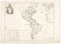
Description:
[Amsterdam: Hondius, circa, 1628. Copper-engraved map, early hand-colouring. French text on verso. Roundels at each corner with inset maps of the Gulf of Mexico, Cuba and Hispaniola, the remaining containing the cartouche. (Expert restoration at sheet edges). A fine example of one of the most celebrated maps of the Americas, the only printed map by Gerard Mercator's grandson Michael. Made by Gerard's grandson Michael to complete the atlas begun by Gerard in 1584 (Atlantis Pars Altera), this map is noted for its outstanding design and beauty, particularly its symmetrical configuration of circular insets and Mannerist flow of vines, flowers and leaves surrounding the circular map. Largely based on Rumold Mercator's world map of 1587, this map aptly reflects 16th-century knowledge, theories and suppositions regarding the New World. Naturally, most of this new knowledge was coastal, and configurations of any large areas were greatly hampered by the lack of a sound means of determining longitude.…
Read More Search Results: South America from Donald Heald Rare Books
You searched for:
- Subject: South America from Donald Heald Rare Books
Results 1 - 11 of 11

America sive India Nova ad magnae Gerardi Mercatoris avi Universalis imitationem in compendium redacta
by MERCATOR, Michael (1565/70-1614)
- Used
- Condition
- Used
- Quantity Available
- 1
- Seller
-
New York, New York, United States
- Item Price
-
A$7,451.80FREE shipping to USA
Show Details
Item Price
A$7,451.80
FREE shipping to USA

More Photos
America Aurea Pars Alter Mundi Auctoribus
by VALK, Gerard (c.1650-1726) & Leonard VALK (1675-1755)
- Used
- Condition
- Used
- Quantity Available
- 1
- Seller
-
New York, New York, United States
- Item Price
-
A$4,314.20FREE shipping to USA
Show Details
Description:
Amsterdam, 1700. Copper-engraved map, full period hand-colouring. Highly decorative map of North and South America showing California as an island and here with full period hand colouring. This decorative map by the Valk brothers is after a similar map by Carol Allard, first published circa 1696. Cartographically, both Allard and the Valks borrow heavily from the De Wit map of 1675, naming the Great Lakes, showing California as an island and with a Terra Esonis and Fretum Anian in the northwest. Interestingly, the Valks here re-issue the first state of Allard's map, i.e. before the re-engraving of the western Great Lakes and the Mississippi River (based on Hennepin's mapping). In addition, the lower left corner of the cartouche is left blank, whereas in subsequent issues of the Allard map, an inset of New Zealand appears. In the present issue, there are no toponyms on Terra Esonis and the South Pacific is without New Guinea. Cf. Burden, The Mapping of North America II: 724 (discussing the map under…
Read More Item Price
A$4,314.20
FREE shipping to USA

More Photos
Carte D'Amerique Dressée pour l'Usage du Roy...1739. America Accurate in Imperia, Regna, Status & Populos Divisa, ad Usum Ludovici XV, Galliarum Regis
by DE L'ISLE, Guillaume and Covens & Mortier
- Used
- Condition
- Used
- Quantity Available
- 1
- Seller
-
New York, New York, United States
- Item Price
-
A$1,255.04FREE shipping to USA
Show Details
Description:
Amsterdam: Covens & Mortier, 1742. Engraving with period outline colour. Some mild soiling. Discolouration at centerfold. An elegant map of North and South America, the most accurate to date, produced for the "usage du Roy," Louis XV. Guillaume de l'Isle (1675-1726) was the son of a cartographer and pupil of Jean Dominique Cassini, who, among other important contributions, aligned the study of astronomy to the study of geography. Under Cassini's direction, observations were made from locations all over the world that enabled longitudinal calculations to be made with much greater accuracy. De l'Isle carried on this exacting work with remarkable dedication and integrity, constantly revising and improving his maps. While precision was his primary goal, his maps are invariably elegant and attractive. Jean (Johannes) Covens and Corneille (Cornelius) Mortier were brothers-in-law, who carried on the book publishing business established by Pierre Mortier in Amsterdam in 1685. Pierre Mortier's company owed…
Read More Item Price
A$1,255.04
FREE shipping to USA

More Photos
Carte Générale de L'Amérique
by PALAIRET, Jean (1697-1774)
- Used
- Condition
- Used
- Quantity Available
- 1
- Seller
-
New York, New York, United States
- Item Price
-
A$941.28FREE shipping to USA
Show Details
Description:
London: Nourse, Vaillant, Millar, Rocque & Sayer, 1754. Copper-engraved map, with full original colour, in very good condition. A highly decorative map of the Americas, evincing Palairet's uniquely elegant aesthetic style This artistically virtuous map embraces the entirety of North and South America, and also takes in the western extremities of Europe and Africa. South America is very well defined, and is divided into the various Spanish domains and Portuguese Brazil. North America is depicted on the eve of the Seven Years War. The English colonies running from Georgia up to Nova Scotia hug the Atlantic seaboard, while the massive French empire consisting of Canada and Louisiana extends through the heart of the continent. Quebec City, the capital of New France, is noted on the map. In the west, California is correctly shown to be a peninsula, while the Pacific Northwest is shown to be an enigma. Mexico and the numerous islands of the Caribbean are also portrayed. The map is adorned with a elegant,…
Read More Item Price
A$941.28
FREE shipping to USA

More Photos
Carte de l'Amerique corrigee et augmentee dessus Toutes les aultres cy devant faictes par P. Bertius
by TAVERNIER, Melchior (1564-1641)
- Used
- Condition
- Used
- Quantity Available
- 1
- Seller
-
New York, New York, United States
- Item Price
-
A$3,922.00FREE shipping to USA
Show Details
Description:
[Paris, 1627. Copper-engraved map, insets of polar regions. Scarce first state of Tavernier's separately-issued map of North America, including insets of the Arctic and Antarctic regions. In 1627, Tavernier, the most important mapseller and publisher in France, published a set of the four continents after Bertius, though possibly without his permission. Although crediting Bertius, the map more closely follows the Hondius mapping of 1618, with the completed northwest coast line, similar mapping of the Great Lakes and similar decorative ships and sea monsters (though without the decorative surround). However, unlike the Hondius map, here the southern coast of Tierra del Fuego is completed, as per the Bertius map of 1624. The map was first issued separately, and then issued in Tavernier's Theatre Geographique. The present example is the rare, separately-issued first state; the subsequent issue published after 1640 included additional toponyms, such as "Neuf Amsterdam" (i.e. New York), "Pleymouth",…
Read More Item Price
A$3,922.00
FREE shipping to USA

More Photos
Isla de Cuba Pintoresca. Collection de Vistas Generales
by BARANANO, Leonardo (1837-1858) and LAPLANTE, Edouardo (1818-1860)
- Used
- Condition
- Used
- Quantity Available
- 1
- Seller
-
New York, New York, United States
- Item Price
-
A$70,596.00FREE shipping to USA
Show Details
Description:
Havana: Santiago Martín, 1856. 8 lithographs, printed in colour and finished by hand, within ruled borders. Sheet size: 20 5/8 x 31 7/8 inches. Very rare series of large coloured lithographs of colonial Cuban towns and harbours. The sought-after collection of Cuban prints, the majority drawn by Barañano, and lithographed by Laplante, comprises the following topographical views, with titles printed in Spanish and English: 1) [General View of Mantanzas] Vista de la Ciudad de Matanzas, Tomada desde el Monte de Cafetal de D. Vicente Guerrero. Includes inset depictions of Palacio de Gobierno, Iglesia Parroquial, Puente de Bailen, and the Hospital Militar. 2) [General View of Havana] La Habana, Vista General Tomada desde la Entrada del Puerto (after L. Barañano) 3) [General View of Trinidad] Trinidad, Vista General Tomada desde la Loma de la Vija (after E. Laplante) 4) [General View of Cardenas] Cardenas, Vista General Tomada desde la Bahia (after L. Barañano) 5) [General View of Cienfuegos]…
Read More Item Price
A$70,596.00
FREE shipping to USA

L'Amerique ou Le Nouveau Continent dressee sur les Memoires les plus nouveaux et sur les Relations les plus recentes, rectifiez sur les dernieres observations. Dediée et Presentée a Monseigneur Law
by NOLIN II, Jean-Baptiste (1686-1762)
- Used
- Condition
- Used
- Quantity Available
- 1
- Seller
-
New York, New York, United States
- Item Price
-
A$3,529.80FREE shipping to USA
Show Details
Description:
Paris: chés l'Auteur rue St. Jacques à l'Enseigne de la Place des Victoires, 1742. Copper-engraved map, period hand colouring in outline. A rare depiction of the mythical Sea of the West. This unusual mapping of North and South America, dedicated to John Law of Mississippi Bubble infamy, includes several mythical elements, including the Sea of the West, Florida as an archipelago and the Riviere Longue. Also of interest is the mapping of islands in the South Pacific, including a much enlarged depiction of New Zealand after Tasman.
Item Price
A$3,529.80
FREE shipping to USA
More Photos
L'Amerique suivant le R. P. Charlevoix J.te, Mr. De La Condamine, et plusiers autres nouv.le observations
by LE ROUGE, Georges Louis (1712-90)
- Used
- Condition
- Used
- Quantity Available
- 1
- Seller
-
New York, New York, United States
- Item Price
-
A$2,823.84FREE shipping to USA
Show Details
Description:
Paris, 1746. Copper-engraved map, period hand-colouring in outline. Table at the bottom left. Mid-18th century French map of North and South America showing the latest Russian and English discoveries in the Arctic: one of the earliest depictions of the discoveries of Bering's second expedition. This decorative map by Le Rouge shows North and South America, with the discoveries of Charlevoix and Condamine added in Canada and the Amazon, respectively. Interestingly, it also shows Aleksei Chirikov's discoveries on the northwest coast during Bering's second expedition, as well as Middleton's Repulse Bay in the Arctic. Concerning the former, Wroth writes: "In 1746 the royal geographer, George Louis Le Rouge, brought out a map entitled L'Amerique, in the northwest corner of which is shown a portion of the 1741 routes of Chirikov and De L'Isle de la Croyere to and from the American coast, the earliest cartographical record, it seems from present knowledge, of the American discoveries of the second Bering…
Read More Item Price
A$2,823.84
FREE shipping to USA

More Photos
A Map of the British Empire in America, with the French and Spanish Settlements Adjacent Thereto
by POPPLE, Henry (1695-1743, Cartographer). TOMS, William Henry (c.1700-1765, Engraver), BARON, Bernard (c.1700-1766, Engraver), SEARLE, Richard William (1732-1785, Engraver)
- Used
- Condition
- Used
- Quantity Available
- 1
- Seller
-
New York, New York, United States
- Item Price
-
A$258,852.00FREE shipping to USA
Show Details
Description:
London: Sold by the Proprietors S[amuel] Harding on the Pavement in St. Martins Lane, and W[illiam] H[enry] Toms, Engraver in Union Court near Hatton Garden Holborn, 1734. Folio. (21 x 15 inches). Engraved folding key map in Babinski State 4, showing the track line of Spanish Galleons. Large engraved wall map on 15 double-page and 5 full-page map sheets, numbered in plate and in contemporary ink manuscript, in Babinski State 7, with Harding and Toms's imprint on map sheet 17, on laid paper with Strasbourg Lily watermarks. Ink manuscript sheet key opposite key map, which also carries ink manuscript configuration guidance. Finely bound to style in period diced quarter calf with tips on marbled paper boards, six raised bands forming seven gilt-ruled compartments with gilt-titling in second. A bound example of the largest eighteenth-century wall map of the Thirteen Colonies, and the first to name all thirteen. Popple's was the first detailed map of British, French, and Spanish colonial possessions in…
Read More Item Price
A$258,852.00
FREE shipping to USA

More Photos
Recentissima Novi Orbis, Sive Americae Septentrionalis et Meridionalis Tabula
by ALLARD, Carol (1648-1709)
- Used
- Condition
- Used
- Quantity Available
- 1
- Seller
-
New York, New York, United States
- Item Price
-
A$2,823.84FREE shipping to USA
Show Details
Description:
Amsterdam, 1697. Copper-engraved map. Small inset of New Zealand within the cartouche. Rare issue of Allard's map of North and South America, the first to show important corrections to the mapping of the Great Lakes and the Mississippi River Valley. "The map of America by Allard is derived from that of Frederick de Wit, c. 1675" (Burden). Significantly, however, Allard corrects the mapping of the Great Lakes and Mississippi Valley. "The former are entirely re-engraved as are the nearby waterways off the St. Lawrence River including Lake Champlain, which is moved south-west. Lake Superior is now enclosed to the west as is Lac des Puans, which is renamed Lac Illinois, placing the previous toponym correctly in Green Bay. To the west an entirely new and more recent depiction of the Mississippi valley is inserted. This is derived from that of Louis Hennepin ... published in 1697" (Burden). This is Burden's second state, with a ruled border surrounding the New Zealand inset but without the textual…
Read More Item Price
A$2,823.84
FREE shipping to USA

Venezuela, cum parte Australi Nova Andalusiae
by BLAEU, Willem (1571-1638) and Jan BLAEU (1596-1673)
- Used
- Condition
- Used
- Quantity Available
- 1
- Seller
-
New York, New York, United States
- Item Price
-
A$1,333.48FREE shipping to USA
Show Details
Description:
Amsterdam, 1640. Engraved map, period hand-colouring in outline. French text on verso. Sheet size: 19 5/8 x 23 1/4 inches. A fine 17th century map of Venezuela and the Lesser Antilles. In the seventeenth century, the Dutch hegemony in ship building and navigation engendered their dominance in mapmaking. At the lead of this field was the Blaeu family. Willem Janszoon Blaeu first studied mathematics and navigation under the famous astronomer Tycho Brahe in 1594, opening his own instrument and globe making shop in Amsterdam in 1599. Shortly thereafter, Willem Blaeu would open a printing house, specializing in works on navigation. The Blaeu family's first world atlas, modestly titled the Atlantis Appendix as it was considered a continuation of the atlases by Ortelius, Mercator and Hondius, was first published in 1630 by Willem Blaeu with his son Joan Blaeu, the official cartographers of the Dutch East India Company. The acclaim that Blaeu's atlases have always received is based primarily upon the…
Read More Item Price
A$1,333.48
FREE shipping to USA

Didn’t find what you’re looking for?
Try adding this search to your want list. Millions of books are added to our site everyday and when we find one that matches your search, we’ll send you an email. Best of all, it’s free.
Add to Want List

Are you a frequent reader or book collector?
Join the Bibliophile's Club and save 10% on every purchase, every day — up to $20 savings per order!

Social Responsibility
Did you know that since 2004, Biblio has used its profits to build 16 public libraries in rural villages of South America?
