Description:
New York City: National Woman Suffrage Publishing Company, Inc, 1919. Very good. 6Âľ" x 4Âľ". Handbill. Very good: 2" stain to lower corner; lightly toned. This is a rare handbill, illustrated with a map showing the status of women's suffrage throughout the United States. In "Make the Map All White: The Meaning of Maps in the Prohibition and Suffrage Campaigns" (University of Colorado Law Review, Volume 92, 2021), author Susan Schulten wrote that a breakthrough in the women's suffrage movement came with a map created by journalist Bertha Knobe for Appleton's magazine in 1907. Rather than show only which states had full suffrage and which did not, Knobe's map used shading to indicate states that had made at least some progress. Schulten argued that the map "caught on for its ability to reframe a period of relative failure as a story of success, which in turn became a call to action. Across the country, suffragists quickly began to create and distribute similar maps to advance state campaigns for…
Read More Search Results: Maps from Langdon Manor Books LLC
You searched for:
- Subject: Maps from Langdon Manor Books LLC
Results 1 - 12 of 12

1919 - Victory Map - 1919
- Used
- very good
- Condition
- Used - Very good
- Quantity Available
- 1
- Seller
-
Houston, Texas, United States
- Item Price
-
A$1,046.59A$12.40 shipping to USA
Show Details
Item Price
A$1,046.59
A$12.40
shipping to USA

Barker, Ralph. Map of the Waterfront of San Francisco From Sonoma St. to Van Ness Ave
- Used
- very good
- Condition
- Used - Very good
- Quantity Available
- 1
- Seller
-
Houston, Texas, United States
- Item Price
-
A$1,162.88A$12.40 shipping to USA
Show Details
Description:
N.p.: N.p., 1908. Very good. 15 3/8" x 41Âľ". Printed on a coated, waxlike paper. Very good : a couple of tiny separations at intersections, small closed tear at another, 2" vertical separation at far upper left, a couple of small edge chips, some scattered pinpoints of soiling. A scarce map of San Francisco's waterfront, its southernmost edge shows a portion of Yuba Street and the far Northwest is a portion of Lewis Street. It also denotes the square footage of 27 labeled seawall lots. The map may have been created to assist its maker in evaluating a number of plans for building up the waterfront, as an application the Embarcadero waterfront entered into the National Register of Historic Places shows his regular involvement in those plans from 1908 onward. We locate only a digital copy at Berkeley.
Item Price
A$1,162.88
A$12.40
shipping to USA

More Photos
Denver & Rio Grande Official Guide to Cities, Villages and Resorts on the Line of the Denver & Rio Grande R.R. . .
- Used
- good
- Condition
- Used - Good
- Quantity Available
- 1
- Seller
-
Houston, Texas, United States
- Item Price
-
A$3,101.00A$12.40 shipping to USA
Show Details
Description:
Denver, Col: The Western Publishing Company, 1888. Good. 9½" x 6ÂĽ". pp. 286, [4] + folding map measuring 17Âľ" x 15". Good: front hinge and first two leaves partially detached but holding, three inch tear to top of backstrip; tiny bit of staining to margins of versos of first 17 leaves. Map very good minus with a 2" jagged tear, two tears at intersections, small separation at one fold and misfolded in a couple spots. A scarce and heavily illustrated directory packed with information on Utah, Colorado and New Mexico. There are entries with information on at least 100 locations, all indexed. Services for each inhabited area follow each description, along with over 200 advertisements (with business names indexed). There are over 70 indexed illustrations as well as an additional 20 in the advertisements themselves, nearly all of which show the buildings of the businesses represented. A history of Colorado, laws relating to game, lists of elected officials, and several profiles of prominent…
Read More Item Price
A$3,101.00
A$12.40
shipping to USA
More Photos
Gay Forum. Vol. 1 No. 3. December 1-15, 1971
- Used
- near fine
- Condition
- Used - Near fine
- Quantity Available
- 1
- Seller
-
Houston, Texas, United States
- Item Price
-
A$1,046.59A$12.40 shipping to USA
Show Details
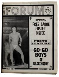
Description:
Washington DC: Guild Press, LTD, 1971. Near fine. 17½" x 11ÂĽ". Bifolia printed on regular paper stock. pp. 24. Near fine: folded horizontally at center as issued, fresh with minimal wear. This is an issue of a short run gay periodical that signaled the downfall of a gay publishing empire. Its publisher, the Guild Press, was founded by H. Lynn Womack, who had turned a small printing plant purchased in 1957 into a major operation which included more than one periodical, book publishing, a chain of gay bookstores, a mail order business--even a movie theater. Womack's accomplishments were not without significant sacrifice: he was arrested more than once for conspiracy to send obscene materials through the mail and his print shop was raided by the Morals Division of the Washington police in 1960. That series of events led to a federal prison sentence, which led to the first case related to homosexuality that went to oral argument before the United States Supreme Court. Womack prevailed in MANual…
Read More Item Price
A$1,046.59
A$12.40
shipping to USA

The Historical Island of Guam of the Marianas Islands
- Used
- very good
- Condition
- Used - Very good
- Quantity Available
- 1
- Seller
-
Houston, Texas, United States
- Item Price
-
A$930.30A$12.40 shipping to USA
Show Details
Description:
Guam: N.P., 1950. Very good. 34" x 31½". Map printed on silk. Very good: numerous light creases and folds; light dust-soiling. This is an intricately pictorial map of the island of Guam, printed on silk and likely issued as a tourist souvenir, with many narrative depictions of Guamanian history and culture. Along with geographical and topographical aspects such as Mt. Lamlam, Guam's highest peak, jungle and coastal areas, the map also features important dates in Guam's history including Magellan's discovery of the island in 1521, "June 20, 1898, Guam surrenders to the U.S. in Spanish-Amer. war," and the landing of United States Marines in July 1944. The map portrays images of Guamanian culture both contemporary and historical, including a cockfight in Piti, net fishermen in Talofofo Bay, and the making of "Tuba, a slightly intoxicating drink." Narratives steeped in fact as well as those of mythology and lore are displayed, such as "Ancient Chomorro could hit a man between the eyes at 50 yards with…
Read More Item Price
A$930.30
A$12.40
shipping to USA
![Hotel Ancira. Monterrey, N.L. Mexico [Cover title]](https://d3525k1ryd2155.cloudfront.net/h/481/905/1445905481.0.m.jpg)
Hotel Ancira. Monterrey, N.L. Mexico [Cover title]
- Used
- very good
- Condition
- Used - Very good
- Quantity Available
- 1
- Seller
-
Houston, Texas, United States
- Item Price
-
A$542.68A$12.40 shipping to USA
Show Details
Description:
Mexico, D.F.: Propaganda y Anuncios S.A., 1939. Very good. 4 1/8" x 12", folded; opens to 23 7/8" x 18 3/8" (map area is 18 5/8" x 17 1/8"). Single sheet printed in multiple colors both sides. Very good: folded twice vertically, possibly as issued; some penciled notations in the margins by the large image of the hotel; a couple of tiny closed tears and one small separation at an intersection. This is a brochure for Monterrey's Hotel Ancira which opens into large, dazzling illustrated map of Mexico which depicts a portion of the Pan-American Highway. On the other side of the sheet is a street map of Monterrey measuring 11" x 8½". On the large map, the Pan-American highway stops furthest north are San Antonio and Del Rio, in Texas, with the furthest south in Tehuantepec. The map contains at least 15 drawings of people dressed in traditional costume. Larger cities are denoted by drawings of buildings and mountain ranges are depicted as well. The map's legend states that locations of hotels and…
Read More Item Price
A$542.68
A$12.40
shipping to USA
More Photos
JCJL Map Showing Routes, Ports of Call and Services of the Java-China-Japan Line . . . [Cover title]/ Java-China Japan Lyn [Map title]
- Used
- very good
- Condition
- Used - Very good
- Quantity Available
- 1
- Seller
-
Houston, Texas, United States
- Item Price
-
A$1,317.92A$12.40 shipping to USA
Show Details
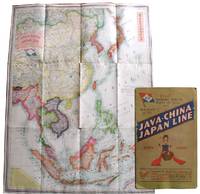
Description:
London, England: Stanford's Geog[raphica]l Estab[lishmen]t, 1931. Very good. Map measuring 44" x 33ÂĽ" partially glued down as issued to heavy card stock bifolium measuring 14Âľ" x 9" and with two pages of text and images on map's verso. Very good: minimal wear to the map which has a few insignificant spots of staining, a few small separations at intersections and a 3" jagged internal tear intersecting the large N and G in MONGOLIA. Bifolium with a 3" split at top of spine and ½" split at bottom, light spotting and edgewear; pages lightly toned with some dogears and scattered spotting. This is a large map of East Asia that doubled as a promotional for the Java-China-Japan Line (JCJL). JCJL was a Dutch-owned company, established in 1902 to serve the shipping routes between the Dutch East Indies, China and Japan. By 1931 JCJL had offices in Amsterdam and ten East Asian cities, with agencies at London, New York and San Francisco. Liners provided regular passenger service between Java and Bali, the…
Read More Item Price
A$1,317.92
A$12.40
shipping to USA
![Map Guide of the Lower Rio Grande Valleys of Texas & Mexico. [Front panel title]](https://d3525k1ryd2155.cloudfront.net/h/731/377/1477377731.0.m.jpg)
More Photos
Map Guide" of the Lower Rio Grande Valleys of Texas & Mexico. [Front panel title]
by White, Russel M.
- Used
- very good
- Condition
- Used - Very good
- Quantity Available
- 1
- Seller
-
Houston, Texas, United States
- Item Price
-
A$1,938.12A$12.40 shipping to USA
Show Details
Description:
Texas: Russel M. White, 1947. Very good. 8 7/8" x 3 7/8", folded; opens to 17Âľ" x 23½"; printed both sides. Very good: light edge wear with a few tiny chips, a few minuscule separations at folds, light dust soiling, and small holes at each intersection. This map/guide to the lower Rio Grande valley is a sensory overload of business, city, street and highway names splashed across 15 separate inset maps in bold explosions of vivid blue and orange. The largest map, which stretches across the entire sheet, shows the region generally along state highways 77, 83 and 281. Each town name is printed in blue inside an orange box. That map is surrounded by inset maps where each town has its name printed in thick orange letters outlined in blue, with the other inset maps on the leaf's other side. The cities and towns represented are: McAllen, Raymondville, Harlingen, Rio Grande City, San Benito, Mission, San Juan, Donna, Weslaco, Mercedes, Edinburg, Pharr, Brownsville, Reynosa, and Matamoros. Several…
Read More Item Price
A$1,938.12
A$12.40
shipping to USA

More Photos
Map Showing Houston & Texas Central System of Railroads. [Front Panel Title: See Texas Via the H And TC. It Takes You Through the Best Farming Country in the State.]
- Used
- very good
- Condition
- Used - Very good
- Quantity Available
- 1
- Seller
-
Houston, Texas, United States
- Item Price
-
A$2,325.75A$12.40 shipping to USA
Show Details
Description:
Chicago: Poole Bros. Map Engravers, 1897. Very good. 8Âľ" x 4" folded; opens to 17½" x 34Âľ"; Map of the United States: 16½" x 30½"; County Map of Texas: 11ÂĽ" x 11ÂĽ". Very good: moderate staining and a few small nibble holes to outer panels costing a couple of characters in panels, and a tiny portion of the main map; a few small separations at intersections. This is a rare timetable/land promotional issued by the Houston and Texas Central System of Railroads ("HTC") with three maps. Chartered in 1848, the line was a predecessor of the Union Pacific Railroad and construction began in 1856. It ultimately stretched 872 miles from Houston to Dallas and Denison with branches to Austin and Waco. The map of the United States is printed in four colors with Texas showing the HTC rail lines in a thick black. There are two illustrated vignettes at bottom, one showing cattle grazing, the other portraying African Americans picking cotton. To the left of the image of cotton picking is a panel of text that…
Read More Item Price
A$2,325.75
A$12.40
shipping to USA

Rand, McNally & Co.'s Indexed County And Railroad Pocket Map And Shippers' Guide Of Texas . .
- Used
- Fine
- Condition
- Used - Fine
- Quantity Available
- 1
- Seller
-
Houston, Texas, United States
- Item Price
-
A$1,395.45A$12.40 shipping to USA
Show Details
Description:
Chicago And New York: Rand, McNally & Co, 1904. Fine. 6 ½" x 4", map measures 27 7/8" x 40". Printed card wrappers. pp. 58 + 6 pages of ads+ folding map. Very good book with moderate wear and a faint dampstain to front wrapper; map fine: bright and fresh with a tiny separation at one margin and a tiny chip at another. An exceptional copy of a map which originally appeared in Rand McNally's Commercial Atlas of America in a much smaller form and was separately issued as early as 1891 with a number of reissues through at least 1911. The text lists hundreds of localities along with respective populations as of 1900. OCLC locates one copy of this edition, we note another previously sold through the trade. This item is offered by Langdon Manor Books, LLC, antiquarian booksellers. Please do not hesitate to contact us for additional information and/or photos and we will respond promptly. We package our items carefully, ship daily, and have a no hassle returns policy--your satisfaction is guaranteed.…
Read More Item Price
A$1,395.45
A$12.40
shipping to USA
![School Atlas to Cummings' Ancient & Modern Geography [Cover title]](https://d3525k1ryd2155.cloudfront.net/h/597/406/1532406597.0.m.jpg)
More Photos
School Atlas to Cummings' Ancient & Modern Geography [Cover title]
- Used
- good
- Condition
- Used - Good
- Edition
- Ninth Edition
- Quantity Available
- 1
- Seller
-
Houston, Texas, United States
- Item Price
-
A$930.30A$12.40 shipping to USA
Show Details
Description:
Boston: Cummings, Hilliard, & Co, 1823. Ninth Edition. Good. 9½" x 6ÂĽ". Thin card wrappers. Eight double-page maps hand-colored in outline. Good: wrappers heavily soiled and separated from text block but attached to each other; three maps with chipping to edges, outside map boundaries; map of Europe with a 3" split at fold; light to moderate dust soiling and offsetting throughout. This is an uncommon book of maps, owned and notated by a Harriet Tousley or Towsley, a woman in her 20s in Ellisburg, New York in the 1820s. The book consists of eight double-page maps including North America and the United States. It was published to accompany the textbook, Cummings' Ancient and Modern Geography, and Tousley noted in this copy that she had purchased both. Her other notes include a date (September 1827) and a fact: "Mississippi River is the largest in the United States of America." Tousley also made notes on geography inside the rear wrapper: "New York Philadelphia Boston Baltimore Charleston and New…
Read More Item Price
A$930.30
A$12.40
shipping to USA
![[Three Pictorial Maps of Los Angeles]](https://d3525k1ryd2155.cloudfront.net/h/551/406/1532406551.0.m.jpg)
More Photos
[Three Pictorial Maps of Los Angeles]
by Pavia, Cathy
- Used
- very good
- Condition
- Used - Very good
- Quantity Available
- 1
- Seller
-
Houston, Texas, United States
- Item Price
-
A$3,101.00A$12.40 shipping to USA
Show Details
Description:
Los Angeles, California: Los Angeles Times, 1980. Very good. Three posters, each measuring 18" x 23". Very good: one tiny tear to edge of one map, light foxing in the margin of another; else minimal wear and light creasing to edges. This is a set of three pictorial maps commissioned for the Los Angeles Bicentennial celebration and originally printed in the Los Angeles Times' Home magazine in 1980. They depict 300 years of Los Angeles area history, though the final hundred had yet to occur. The artist, Cathy Pavia, is a longtime art instructor and freelance illustrator for advertising and magazines. She also created the art for several books, including the Cathy and Company children's book series and Joey Green's The Zen of Oz: Ten Spiritual Lessons from Over the Rainbow. Each map has a key with between 22 and 38 highlighted areas, with text corresponding to each number along the bottom. The map entitled "The first hundred years, 1781-1881" stretches from Shoo Fly Pier, Santa Monica in the west to…
Read More Item Price
A$3,101.00
A$12.40
shipping to USA

Didn’t find what you’re looking for?
Try adding this search to your want list. Millions of books are added to our site everyday and when we find one that matches your search, we’ll send you an email. Best of all, it’s free.
Add to Want List

Are you a frequent reader or book collector?
Join the Bibliophile's Club and save 10% on every purchase, every day — up to $20 savings per order!

Social Responsibility
Did you know that since 2004, Biblio has used its profits to build 16 public libraries in rural villages of South America?
