Description:
details:color lithograph, green, black and white, double sided mapdimensions: 20 1/8" x 24" condition: good, professionally conserved, paper deacidified, original folds flattened,small loss at fold intersections filled Description: This decorated and doubled sided map of the City and County of San Francisco on the front presents a vignette of the Lurline Ocean Water Baths in San Francisco. The map also features an advertisement by George L. Suhr, of Suhr & Wieboldt Funeral Directors with the early telephone exchange Mission 1. The map is copyright but not dated. A date range of 1918 to 1920 is most likely, due to the presence on the map of the Twin Peaks Tunnel that opened to Muni service in 1918. Candrian was a San Francisco and vicinity tour operator and published maps and guide books to San Francisco, Oakland and surrounding cities with special reference to public transportation. Therefore, the presence of train, municipal and other transit lines such as ferry on his maps is an essential…
Read More Search Results: Authors starting with A from Original Antique Maps
You searched for:
- Bookseller inventory: Original Antique Maps (authors starting with A)
- Bookseller: Original Antique Maps
Results 1 - 6 of 6

More Photos
Map of the City and County of San Francisco. c.1918-1920
by H.A.Candrian
- Used
- Condition
- Used
- Quantity Available
- 1
- Seller
-
FRAMINGHAM, Massachusetts, United States
- Item Price
-
A$1,058.94A$17.26 shipping to USA
Show Details
Item Price
A$1,058.94
A$17.26
shipping to USA
![Superior-Quetico [Minnesota-Ontario] Canoe Maps, 1952, lot of 5](https://d3525k1ryd2155.cloudfront.net/h/154/592/1539592154.0.m.jpg)
More Photos
Superior-Quetico [Minnesota-Ontario] Canoe Maps, 1952, lot of 5
by W.A. Fisher
- Used
- Condition
- Used
- Quantity Available
- 1
- Seller
-
FRAMINGHAM, Massachusetts, United States
- Item Price
-
A$470.64A$17.26 shipping to USA
Show Details
Description:
Map Details:color printed, double sided guide maps on crinkled, waxed papercondition: good, as found, working maps, some with original fold lines, occasional edge wearDimensions: 20 3/4" x 15 3/4"Map Descriptions:Superior-Quetico [Minnesota-Ontario] Canoe Maps, 1952, lot of 5:No. 104 Jean-Pickerel LakesNo. 107 Crane-Sand Point Point-Lac La CroixNo. 108 Crooked-Agnes LakesNo. 1112 Burntside-Basswood LakesNo. 113 Moose-Knife-Insula LakesThe Superior-Quetico Wilderness straddles the Minnesota-Canada border. The map key and map notes describe this region as a 14,500 mile "wilderness empire" and labyrinth of connecting lakes. A boundary chain of lakes extends 2,000 miles westerly from Lake Superior to International Falls. Another route called The Hunter's Island Route runs north into Canada for 60 miles. The map states (and warns) "The wilderness is only accessible by canoe and pack." The purpose of the W.A.Fisher canoe maps is to permit planning a canoe trip to this vast wilderness of lakes, falls and… Read More
Item Price
A$470.64
A$17.26
shipping to USA

A Mapp of the Sommer Islands Once Called the Bermudas: Mappa Aestivarum Insularum alias Bermudas dictarum
by Abraham Goss
- Used
- Condition
- Used
- Quantity Available
- 1
- Seller
-
FRAMINGHAM, Massachusetts, United States
- Item Price
-
A$2,510.08A$17.26 shipping to USA
Show Details
Description:
Details:double sided, engraved, black and white as publisheddimensions: 16 ½" x 21 ½"professionally conserved, original fold reinforced on verso, small marginal tear repaired on versoDescription: This 17th century map of the Sommer Islands, published in England "to be sold by George Humble in Pops-head Alley" is an early, rare edition that lists the names of the island's original English settlers and shows their houses, a castle, a church and other buildings throughout the settled lots. A miniature image of the Bermuda islands appears below the map title block in which the map title is written in both English and Latin. Two engraved shields decorate the lower corners. The scale of distance is also in English and Latin provided to measure the sailing distance from Bermuda to Virginia, New England and Hispaniola in English miles. Two double masted ships are shown sailing north from Bermuda to each of these destinations.
The English text on the map's verso explains the unintended… Read More
Item Price
A$2,510.08
A$17.26
shipping to USA

More Photos
Boston, 1857 (manuscript proof approval verso): Framed period engraving examined out of frame
by after J.W.Hill, artist
- Used
- Condition
- Used
- Quantity Available
- 1
- Seller
-
FRAMINGHAM, Massachusetts, United States
- Item Price
-
A$3,922.00A$17.26 shipping to USA
Show Details
Description:
Details:19th c. hand colored steel plate engraving after watercolor by John W. Hill, Boston, 1853 with gilt wood frame and glass as found and removed from frameCharles Mottram, [London]EngraverMcQueen [London], PrinterPaul & Dominic Colnaghi & Co., London, Smith Brothers & Co., New York, at Sowle & Wards, 14 Summer St., Boston, Paris F Delarue Rue J.J. Rouseau 18, Publishers, B.[enjamin].F.[ranklin] Smith, Copyright 1857, District of Massachusettsdimensions: print image without lettering: 38 3/4" x 24 3/4"dimensions: print sheet :42" x 28 1/2"condition: as found, removed from gilt wood frame, original complex bright colors, period paper, ample margins, paper lightly toned, two areas of vertical toning in the image, manuscript pencil on back of print "N.S. Dearborn, 24 School Street, Boston" and "Good", visible engraving plate impression in print sheetDescription: This distinctively inscribed example of the 1857 print Boston, is a period, colored steel plate engraving by Charles Mottram…
Read More Item Price
A$3,922.00
A$17.26
shipping to USA

More Photos
Aldus Chapin Higgins Photo Album, 1923 A Ten Weeks Vacation Trip to Europe February 23rd to May 12th 1923: [Madeira, Gibraltar, Algiers, France, Sicily, Italy, Switzerland, New York]
by Aldus Higgins
- Used
- Condition
- Used
- Edition
- Hand made book
- Quantity Available
- 1
- Seller
-
FRAMINGHAM, Massachusetts, United States
- Item Price
-
A$10,197.20A$17.26 shipping to USA
Show Details
Description:
Photo Archive and Hand Made Book Details:Large format, elaborate hand-made book, unpaginated [95 pages], colored ink manuscript calligraphy on cover, bound in leather parchment over stiff boards, 306 large and medium format professional black and white photographs mounted on laid paper with deckled edges, each photo titled in manuscript, 3-page typed itinerary bound in at end of book, one small landscape oil painting "Taormina" bound in, 2-page color printed map laid in with itinerary hand drawn on map, separate set of 7 small format B&W photographs of the architecture of the Higgins home, newly completed, Worcester, Massachusetts, and one engraved calling card of Mr. and Mrs. Aldus Chapin Higgins 1 John Wing Road [Worcester, Massachusetts].dimensions: 15 1/8" x 11 1/4" x 3"condition: book: as found, 100-year old parchment binding in good condition, parchment covers have some wear, condition: contents: as found, very good to excellent, heavy laid paper pages, a small Higgins oil painting, manuscript… Read More
Item Price
A$10,197.20
A$17.26
shipping to USA
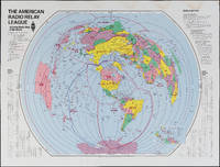
The Amateur Radio Relay League: Amateur Radio Map of the World
by American Radio Relay League
- Used
- Condition
- Used
- Quantity Available
- 1
- Seller
-
FRAMINGHAM, Massachusetts, United States
- Item Price
-
A$509.86A$17.26 shipping to USA
Show Details
Description:
Color print on glossy paperDimensions: 31" x 40 3/4"Condition: as found, water stain along top margin, bright colors throughoutThis American Radio Relay League divides the world into radio relay league zones rather than political or geographic boundaries. The map could be thought of as a ham radio listeners "bird's ear" view of the world. Each zone is identified by the call letters for that zone, immediately recognizable to the experienced ham radio operator and part of a language unique to this kind of radio communication.
Item Price
A$509.86
A$17.26
shipping to USA

Didn’t find what you’re looking for?
Try adding this search to your want list. Millions of books are added to our site everyday and when we find one that matches your search, we’ll send you an email. Best of all, it’s free.
Add to Want List

Are you a frequent reader or book collector?
Join the Bibliophile's Club and save 10% on every purchase, every day — up to $20 savings per order!

Social Responsibility
Did you know that since 2004, Biblio has used its profits to build 16 public libraries in rural villages of South America?
