Description:
London; IMITATIONS OF ORIGINAL DRAWINGS BY HANS HOLBEIN, IN THE COLLECTION OF HIS MAJESTY, FOR THE PORTRAITS OF ILLUSTRIOUS PERSONS OF THE COURT OF HENRY VIII. WITH BIOGRAPHICAL TRACTS. John Chamberlaine., 1797. Bartolozzi developed his style to imitate the subtleties of renaissance and baroque chalk drawings and became deservedly famous for his stipple engraving. The portraits in this collection show how effective this technique was in reproducing with such incredible fidelity Holbein's original designs. Accompanied by a biographical tract giving a brief history of M. Souch. Engraved by BARTOLOZZI, Francesco. Size: 260 x 340 mm. Stipple engraving. Printed colour. Fine condition.
Search Results: Titles starting with M from Peter Harrington
You searched for:
- Bookseller inventory: Peter Harrington (titles starting with M)
- Bookseller: Peter Harrington
Results 1 - 20 of 806

M. Souch.
by HOLBEIN, Hans.
- Used
- Condition
- Used
- Quantity Available
- 1
- Seller
-
London, United Kingdom
- Item Price
-
A$540.62A$23.59 shipping to USA
Show Details
Item Price
A$540.62
A$23.59
shipping to USA

MAGDEBURGUM.
by MERIAN, Matthew.
- Used
- Condition
- Used
- Quantity Available
- 1
- Seller
-
London, United Kingdom
- Item Price
-
A$344.03A$23.59 shipping to USA
Show Details
Description:
Frankfurt., 1649. Panoramic town view of Magdeburg in the seventeenth century, showing all the main buildings (key to the buildings in top corners). This town plan was one of many engravings originally published in Merian's Theatrum Europaeum that were incorporated into later editions of Gottfried's chronicles. Copper engraving. Uncoloured. Slightly darkened fold, left of centre, and stain near top edge not affecting image. Very good condition. Size: 54 x 15 cm.
Item Price
A$344.03
A$23.59
shipping to USA

MAGNESIA.: Manisa, Turkey.
by LE BRUYN, Cornelius.
- Used
- Condition
- Used
- Quantity Available
- 1
- Seller
-
London, United Kingdom
- Item Price
-
A$235.91A$23.59 shipping to USA
Show Details
Description:
Amsterdam., 1700. Handsome view of the Turkish city of Manisa, inland from Izmir. Two figures seated in the foreground, the walled city with many minarets, and mountains beyond. Voyages in the Levant. Copper engraving. Later colour. Fine condition. Size: 40.5 x 30 cm.
Item Price
A$235.91
A$23.59
shipping to USA
![[MAINZ].](https://d3525k1ryd2155.cloudfront.net/h/883/198/319198883.0.m.jpg)
[MAINZ].
by MERIAN, Matthew.
- Used
- Condition
- Used
- Quantity Available
- 1
- Seller
-
London, United Kingdom
- Item Price
-
A$344.03A$23.59 shipping to USA
Show Details
Description:
J.L. Gottfried's Archontologica Cosmica., 1649. Beautiful town plan of Mainz in the seventeenth century, showing all the main buildings (listed at lower right). This town plan was one of many engravings originally published in Merian's Theatrum Europaeum that were incorporated into later editions of Gottfried's chronicles. Copper engraving. Uncoloured. Slightly darkened centrefold, not affecting image. Very good condition. Size: 35.5 x 26.5 cm. (14 x 10½ inches).
Item Price
A$344.03
A$23.59
shipping to USA

MALTA. MELITA.
by Westall, W.
- Used
- Condition
- Used
- Quantity Available
- 1
- Seller
-
London, United Kingdom
- Item Price
-
A$88.47A$23.59 shipping to USA
Show Details
Description:
W.R.McPhun. Glasgow, c.1840. Engraved by Cooke, W.J. Steel engraving. Hand coloured. Fine condition. Size: 19 x 13 cm.
Item Price
A$88.47
A$23.59
shipping to USA

MANTUA DUCATUS
by MERIAN, Matthew
- Used
- Condition
- Used
- Quantity Available
- 1
- Seller
-
London, United Kingdom
- Item Price
-
A$432.50A$23.59 shipping to USA
Show Details
Description:
Topographia., 1688.. A fine map of the region of Mantua, northern Italy. Title in decorated cartouche at top right, decorated scale at bottom. Copper engraving. Later colour. Very good condition. Size: 37 x 27.5 cm. (14½ x 11 inches)
Item Price
A$432.50
A$23.59
shipping to USA

MANTUA DUCATUS
by BLAEU, Willem.
- Used
- Condition
- Used
- Quantity Available
- 1
- Seller
-
London, United Kingdom
- Item Price
-
A$776.53A$23.59 shipping to USA
Show Details
Description:
Amsterdam., c1650. Beautiful map of Mantua area, showing the city surrounded by water, the districts, cornfields rivers and surrounding towns. Ornamental cartouche at top right, secondary cartouche with two scales, decorated with globe, scrolls, book and compass. Beadwork border. Copper engraving. Later colouring. Fine condition, 3cm closed tear at lower centre fold, not affecting map Excellent wide margins Size: 47.5 x 35 cm.
Item Price
A$776.53
A$23.59
shipping to USA
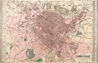
MAP OF BIRMINGHAM divided into half mile squares and circles: 64.
by BACON, George Washington.
- Used
- Condition
- Used
- Quantity Available
- 1
- Seller
-
London, United Kingdom
- Item Price
-
A$186.76A$23.59 shipping to USA
Show Details
Description:
London., c.1885. A highly detailed mapof the city of Birmingham,showing museums, buildings, roads and railways, parks and waterways. The plan is flanked by a comprehensive index of streets. Lithograph. Original colour. Very good condition. Size: 49 x 31 cm.
Item Price
A$186.76
A$23.59
shipping to USA

A MAP OF FRANCE With the Dominions appertaining thereto, &c
by SEALE, Richard William, 1732-1785
- Used
- Condition
- Used
- Quantity Available
- 1
- Seller
-
London, United Kingdom
- Item Price
-
A$344.03A$23.59 shipping to USA
Show Details
Description:
Mr Tindal's Continuation of Rapin's History., c1745.. A detailed map of France with title cartouche at left, and key and scale at bottom right. Copper engraving. Hand coloured. Very good condition. Small crease at bottom right. Size: 47 x 38 cm. (18½ x 15 inches)
Item Price
A$344.03
A$23.59
shipping to USA

A MAP OF FRANCE With the Dominions appertaining thereto, &c
by SEALE, Richard William, 1732-1785
- Used
- Condition
- Used
- Quantity Available
- 1
- Seller
-
London, United Kingdom
- Item Price
-
A$324.37A$23.59 shipping to USA
Show Details
Description:
Mr Tindal's Continuation of Rapin's History., c1745.. A detailed map of France with title cartouche at left, and key and scale at bottom right. Copper engraving. Hand coloured. Very good condition. Margins very close to edge at top left and bottom left, but still enough room for mounting and framing. Size: 47 x 38 cm. (18½ x 15 inches).
Item Price
A$324.37
A$23.59
shipping to USA

A MAP OF NORTH AMERICA With the European Settlements & whatever else is remarkable in ye. WEST INDIES from the latest and best Observations.
by RAPIN DE THOYRAS, Paul.
- Used
- Condition
- Used
- Quantity Available
- 1
- Seller
-
London, United Kingdom
- Item Price
-
A$2,948.85A$23.59 shipping to USA
Show Details
Description:
London. , c1745. Very attractive eighteenth century map of North America produced at a transitional point in terms of European understanding of the geography of the New World - the Mississippi Valley, Mexico, the Great Lakes, and the Atlantic Coast are portrayed in detail with great accuracy, while the north-western portion of the continent is labelled "Parts Unknown" and California is depicted as an island. It is one of the last maps to perpetuate that misinformation about California, which had influenced cartography for some 145 years. Also shown are routes of explorers, mountains as raised topography, European and Indian towns, forts, and castles. Shaded areas marked with arrows indicate the trade winds. Decorative title cartouche at lower right. The map was drawn & engraved by Richard Wilson Seale (fl.1732-1773) for "The History of England" Written in French by Mr. Rapin de Thoyras. Translated into English with Additional Notes by N. Tindal. M.A. the Vicar of Great Waltham in Essex, England. This…
Read More Item Price
A$2,948.85
A$23.59
shipping to USA

A MAP OF PART OF THE ROMAN PROVINCE.: Vol.V. Plate VIII. Page 199.
by Unknown.
- Used
- Condition
- Used
- Quantity Available
- 1
- Seller
-
London, United Kingdom
- Item Price
-
A$344.03A$23.59 shipping to USA
Show Details
Description:
c1700. An interesting map showing Provence in France. Map indicating rivers, mountains, towns, aqueducts and military camps. The map extends from Avignon to Marseille and from Nimes to Saint Maximin, with Campus Lapideus in the centre. Copper engraving. Hand coloured. Very good condition; a few small wormholes, a crease across bottom right corner, light age toning of sheet. Size: 28.5 x 22 cm. (11 x 8½ inches)
Item Price
A$344.03
A$23.59
shipping to USA

MAP OF THE County OF NORTHAMPTON, from an Actual Survey made in the years 1825 & 1826
by GREENWOOD, C&J. Engraved by WALKER, J&C.
- Used
- Condition
- Used
- Quantity Available
- 1
- Seller
-
London, United Kingdom
- Item Price
-
A$776.53A$23.59 shipping to USA
Show Details
Description:
Atlas of the Counties of England from Actual Surveys Made from the Years 1817-1832. Greenwood and Co., London., 1834.. Large decorative map of Northamptonshire with vignette of Peterborough Cathedral lower right. During the eighteenth century each county map was a separate project sponsored by the local gentry. By 1800 nearly all English counties had been surveyed. In the early nineteenth century two enterprises attempted to survey all the English counties: the brothers Christopher and John Greenwood, and Andrew Bryant. This map comes from the Greenwoods atlas, which was published in parts, but was never completed. Steel engraving. Original colour with later additions. Good condition, 3 inch tear on right side, red ink on title has bled. Size: 73 x 62 cm. (28½ x 24½ inches) H.Wallis "Historian Guide to Early British Maps", p.22
Item Price
A$776.53
A$23.59
shipping to USA

A MAP OF TERRA FIRMA.: Guiana and the Antilles islands.
by MOLL, Herman
- Used
- Condition
- Used
- Quantity Available
- 1
- Seller
-
London, United Kingdom
- Item Price
-
A$432.50A$23.59 shipping to USA
Show Details
Description:
Atlas Geographus., 1711-17. A map of the Dutch Antilles in the West Indies. A library stamp on the reverse shows through slightly. Size: 26.6 x 18.8 cm. (10½ x 7½ inches) Copper engraving. Original colour. Very good condition.
Item Price
A$432.50
A$23.59
shipping to USA

A MAP of ASSYRIA & BABYLONIA according to this History
by BONVEN, E.
- Used
- Condition
- Used
- Quantity Available
- 1
- Seller
-
London, United Kingdom
- Item Price
-
A$186.76A$23.59 shipping to USA
Show Details
Description:
A stunning map of Assyria, illustrating the mountainous regions, the Euphrates and Tigris rivers and their tributaries. Copper engraving. Original colour. Very good condition with wide margins. Size: 26.7 x 27 cm. (10½ x 10½ inches)
Item Price
A$186.76
A$23.59
shipping to USA

MAP of the County of CUMBERLAND, from an Actual Survey made in the Years 1821 & 1822.
by GREENWOOD, C&J. Engraved by DOWER, J.
- Used
- Condition
- Used
- Quantity Available
- 1
- Seller
-
London, United Kingdom
- Item Price
-
A$589.77A$23.59 shipping to USA
Show Details
Description:
London., 1834. Large and attractive map of Cumberland with a detailed and decorative vignette view of Carlisle Cathedral lower right. During the eighteenth century each county map was a separate project sponsored by the local gentry. By 1800 nearly all English counties had been surveyed. In the early nineteenth century two enterprises attempted to survey all the English counties: the brothers Christopher and John Greenwood, and Andrew Bryant. This map comes from the Greenwoods atlas, which was published in parts, but was never completed. Steel engraving. Original colour with later additions. Very good condition; small repaired tear to top margin; light stains to margins, very slightly affecting the image. Size: 73.5 x 63 cm. H.Wallis "Historian Guide to Early British Maps", p.22
Item Price
A$589.77
A$23.59
shipping to USA

MAP of the COUNTY of WORCESTER, from an Actual Survey made in the Years 1820 & 1821.
by GREENWOOD, C&J. Engraved by WALKER, J&C.
- Used
- Condition
- Used
- Quantity Available
- 1
- Seller
-
London, United Kingdom
- Item Price
-
A$589.77A$23.59 shipping to USA
Show Details
Description:
Atlas of the Counties of England from Actual Surveys Made from the Years 1817-1832. Greenwood and Co., London., 1834.. Large and attractive map of Worcestershire with a detailed and decorative vignette view of Worcester Cathedral lower left. During the eighteenth century each county map was a separate project sponsored by the local gentry. By 1800 nearly all English counties had been surveyed. In the early nineteenth century two enterprises attempted to survey all the English counties: the brothers Christopher and John Greenwood, and Andrew Bryant. This map comes from the Greenwoods atlas, which was published in parts, but was never completed. Steel engraving. Original colour with later additions. Good condition; a 5 inch tear across upper right margin, slightly affecting the image. Size: 73.5 x 63 cm. (29 x 25 inches) H.Wallis "Historian Guide to Early British Maps", p.22
Item Price
A$589.77
A$23.59
shipping to USA
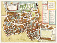
A MAPP of the PARISH OF St GILES'S IN THE FIELDS TAKEN FROM THE LAST SURVEY, WITH CORRECTIONS AND ADDITIONS
by STOW, John. London West End
- Used
- Condition
- Used
- Quantity Available
- 1
- Seller
-
London, United Kingdom
- Item Price
-
A$540.62A$23.59 shipping to USA
Show Details
Description:
A Survey of the Cities of London & Westminster. John Strype., 1755.. John Stow's, A Survey of London, was first published in 1598, with a second edition following in 1603. Stow's most famous work, it is an evocative 'perambulation' of the streets of the Tudor capital, which forms the main framework of the book. The huge growth of the metropolis, the devastation wrought by the Great Fire of 1666 and the subsequent rebuilding of the City made an updating of the Survey highly desirable. It was to answer this need that John Strype (1643-1737), the ecclesiastical historian and biographer, published a new, hugely expanded version of Stow's Survey of London in 1720. Copper engraving. Hand coloured. Good condition Size: 36.5 x 30.4 cm. (14½ x 12 inches)
Item Price
A$540.62
A$23.59
shipping to USA
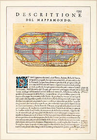
MAPPA MONDO.
by PORCACCHI DA CASTIGLIONE, Thomaso.
- Used
- Condition
- Used
- Quantity Available
- 1
- Seller
-
London, United Kingdom
- Item Price
-
A$688.06A$23.59 shipping to USA
Show Details
Description:
Venice: L'Isole Piu Famoso del Mondo., 1590. A pretty oval map of the world. The maps for this atlas were engraved by Girolamo Porro from Padua, and are set within a page of text, with engraved headpiece and decorated initial. There were many editions of this popular atlas between 1576 and 1713. Size: 145 x 240 mm. Mounted size: 300 x 400 mm. Copper engraving. Later colour. A fine, crisp impression. Fine condition. Moreland and Bannister, p.68
Item Price
A$688.06
A$23.59
shipping to USA

MAPPAE IMPERII MOSCOVITICI pars Septentrionalis adornata per Guilliemum de L'Isle.
by SEUTTER, Matthias.
- Used
- Condition
- Used
- Quantity Available
- 1
- Seller
-
London, United Kingdom
- Item Price
-
A$1,179.54A$23.59 shipping to USA
Show Details
Description:
Augsburg: , c.1730. Matthias Seutter's attractive map of northern European Russia, from St Petersburg north to the Arctic Ocean. Decorated title cartouche at top right. Copper engraving. Original colour. Fine condition. Size: 57 x 49.5 cm. (22½ x 19½ inches).
Item Price
A$1,179.54
A$23.59
shipping to USA

Didn’t find what you’re looking for?
Try adding this search to your want list. Millions of books are added to our site everyday and when we find one that matches your search, we’ll send you an email. Best of all, it’s free.
Add to Want List

Are you a frequent reader or book collector?
Join the Bibliophile's Club and save 10% on every purchase, every day — up to $20 savings per order!

Social Responsibility
Did you know that since 2004, Biblio has used its profits to build 16 public libraries in rural villages of South America?
