Skip to content

Search Results: Titles starting with P from Original Antique Maps

You searched for:
  • Bookseller inventory: Original Antique Maps (titles starting with P)
  • Bookseller: Original Antique Maps
Results 1 - 9 of 9
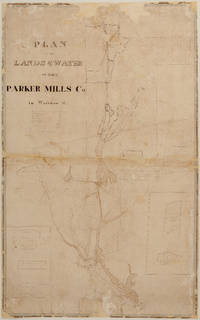
PLAN OF THE LANDS & WATER OF THE PARKER MILLS CO. in Wareham, Mass.  - Manuscript (nd) (c. 1834?)

PLAN OF THE LANDS & WATER OF THE PARKER MILLS CO. in Wareham, Mass. - Manuscript (nd) (c. 1834?)

by Sylvanus Bourne

  • Used
Condition
Used
Quantity Available
1
Seller
FRAMINGHAM, Massachusetts, United States
Seller rating:
This seller has earned a 5 of 5 Stars rating from Biblio customers.
Item Price
A$2,015.65
A$17.06 shipping to USA

Show Details

Description:
Details:S[ylvanus]. Bourne, Surveyormanuscript survey map, hand inked, with partial water color, a working map with some ink overwriting in a different handdimensions: 36 ¾" x 23 1/8"condition: original inks and water colors, cleaned, professionally conserved, original fabric backing removed, area of loss due to a hungry mouse filled, other paper loss filled, unbacked. Description:
This undated manuscript
Plan of the Lands & Water of the Parker Mills Co. in Wareham, Mass. c. 1834? is a rare, new discovery that offers a detailed view of Wareham in its early industrial period. The scope of the Plan of the Lands and Water of the Parker Mills Co. (the "Plan")
is defined by the geographic scope of the property of one of Wareham's major iron and nail manufacturers, the Parker Mills Co., whose business history begins in the 1830's, and predate its 1845 legal incorporation by Act of the Massachusetts Legislature. The predecessor to the Parker Mills Co. was the Wareham Iron Co. (Tihonet Pond Upper Works… Read More
Item Price
A$2,015.65
A$17.06 shipping to USA
[Pacific Ocean and South Seas 1838-1842, American Nautical Charts] Set of 15 navigation charts by
More Photos

[Pacific Ocean and South Seas 1838-1842, American Nautical Charts] Set of 15 navigation charts by: United States Exploring Expedition. During the Years 1838,1839,1840,1841,1842. Under the Command of Charles Wilkes, U.S.N. Atlas of Charts. VOL. I. and VOL. II From the Surveys of the Expedition.

by Charles Wilkes

  • Used
Condition
Used
Edition
By Authority of Congress.
Quantity Available
1
Seller
FRAMINGHAM, Massachusetts, United States
Seller rating:
This seller has earned a 5 of 5 Stars rating from Biblio customers.
Item Price
A$26,358.50
A$17.06 shipping to USA

Show Details

Description:
United States Exploring Expedition. During the Years 1838,1839,1840,1841,1842. Under the Command of Charles Wilkes, U.S.N.
Atlas of Charts.
VOL. I. and VOL. II From the Surveys of the Expedition.By Authority of Congress. PhiladelphiaC. [onger] Sherman, printer. 1850.Vol. I. , 1850 a bound issue of 55 unnumbered charts. Also sold separately.1/

Details:black and white engraved charts on heavy paper, a printed oval stamp with Navy anchor and "U.S.Ex.Ex.", and "Price thirteen cents" on each single page chart
engravers: G.W. Boynton, J. Knight, George G. Smith, Sherman & Smith, and unsigned
dimensions: 26 1/2" x 19 1/2" approx., sheet size
condition: professionally conserved, good condition
Please see Part II. for a list of titles and individual chart descriptions.I. Description
Like a Homeric odyssey, the United States Exploring Expedition (1838-1842), its six vessels2/, 346 man crew3/ of scientists, artists, naval officers and other personnel commanded by then U.S. Navy Lieut. Charles… Read More
Item Price
A$26,358.50
A$17.06 shipping to USA
Pacific Ocean, Sheet 9, Western Australia to Tasmania

Pacific Ocean, Sheet 9, Western Australia to Tasmania: [Western Australia to Tasmania 1857]

  • Used
Condition
Used
Quantity Available
1
Seller
FRAMINGHAM, Massachusetts, United States
Seller rating:
This seller has earned a 5 of 5 Stars rating from Biblio customers.
Item Price
A$1,550.50
A$17.06 shipping to USA

Show Details

Description:
Pacific Ocean, Sheet 9, Western Australia to Tasmania London, Published at the Admiralty February 27, (1857) under the superintendence of Capt. Washington R.N.F.R.S. Hydrographer.Engraved by J. & C. Walker
Details:two toned, stippled black and white engraving, beacons and lights in yellow and red, manuscript pencil charting from Melbourne west and north westdimensions: 33 1/2 x 26 1/4 inches approx. sheet sizecondition: professionally conserved, backed with Japanese tissue, some edge wear, stain in top right corner area, paper lightly toned otherwise good condition.
Description:
Brief Description:
This British working sea chart of the West Coast of Australia also labels the locations of South Australia, New South Wales, Victoria and the island of Tasmania. The mountain ranges in New South Wales and Victoria are shown graphically, with height in feet. Other topographical features, such as the Torrens Basin and Stony Desert are located and labeled on the chart. Towns and cities, ports and… Read More
Item Price
A$1,550.50
A$17.06 shipping to USA
Pacific Ocean and South Seas 1838-1842, U.S. Ex.Ex. American Nautical Charts - Set of 15
More Photos

Pacific Ocean and South Seas 1838-1842, U.S. Ex.Ex. American Nautical Charts - Set of 15: United States Exploring Expedition. During the Years 1838,1839,1840,1841,1842. Under the Command of Charles Wilkes, U.S.N. Atlas of Charts. VOL. I. and VOL. II From the Surveys of the Expedition. By Authority of Congress. Philadelphia C. [onger] Sherma

by United States Exploring Expedition (U.S.Ex.Ex.)

  • Used
Condition
Used
Quantity Available
1
Seller
FRAMINGHAM, Massachusetts, United States
Seller rating:
This seller has earned a 5 of 5 Stars rating from Biblio customers.
Item Price
A$26,358.50
A$17.06 shipping to USA

Show Details

Description:
Chart and Capt. Charles Wilkes Calling Card Details:Lot of 15 black and white independently issued engraved charts on heavy paper, bearing a printed oval stamp with Navy anchor and "U.S.Ex.Ex.", and "Price thirteen cents" on each chart, with occasional period manuscript notation on versoengravers: G.W. Boynton, J. Knight, George G. Smith, 2, and unsigneddimensions: 26 1/2" x 19 1/2" approx., sheet sizecondition: professionally conserved, good condition, working charts have manuscript notations
Capt. Charles Wilkes calling card:as found with manuscript ink inscriptiondimensions: 3 1/2" x 2 1/8"
Please see Part II. for a list of the fifteen (15) U.S. Ex.Ex. chart titles and individual chart descriptions.
I. Brief History and Description of the U.S. Exploring Expedition:
Like a Homeric odyssey, the United States Exploring Expedition (1838-1842), its six vessels2/, 346 man crew3/ of scientists, artists, naval officers and other personnel commanded by then U.S. Navy Lieut. Charles Wilkes (1798-1877), set… Read More
Item Price
A$26,358.50
A$17.06 shipping to USA
Pacific Ocean, Sheet 3, Cook River to Gulf of California 1856

Pacific Ocean, Sheet 3, Cook River to Gulf of California 1856

  • Used
Condition
Used
Quantity Available
1
Seller
FRAMINGHAM, Massachusetts, United States
Seller rating:
This seller has earned a 5 of 5 Stars rating from Biblio customers.
Item Price
A$1,550.50
A$17.06 shipping to USA

Show Details

Description:
Pacific Ocean, Sheet 3, Cook River to Gulf of CaliforniaLondon, Published at the Admiralty October 1, (1856) under the superintendence of Capt. Washington R.N.F.R.S. Hydrographer.Engraved by J. & C. Walker
Details:two toned, stippled black and white engraving, beacons and lights in yellow and red, manuscript pencil charting from or to Port San Franciscodimensions: 32 x 25 ¾ inches approx. sheet sizecondition: professionally conserved, backed with Japanese tissue, repaired tears lower margin, some wrinkling and ridges in paper, paper toned.Description: The chart of the North American West Coast includes the British and Russian Possessions, the American west coast labeled as Oregon and California, and a small portion of Mexico below the American-Mexico border to its Bay of San Francisco. The Oregon Territory was created in 1848. Oddly, the American Territory of Washington created by act of March 2, 1853 is not indicated on this 1856 British chart.
This working sea chart is Sheet 3 of a… Read More
Item Price
A$1,550.50
A$17.06 shipping to USA
Plan of Oldfields Sherborn Mass. Estate of Herbert W. Moses

Plan of Oldfields Sherborn Mass. Estate of Herbert W. Moses

  • Used
Condition
Used
Quantity Available
1
Seller
FRAMINGHAM, Massachusetts, United States
Seller rating:
This seller has earned a 5 of 5 Stars rating from Biblio customers.
Item Price
A$1,395.45
A$17.06 shipping to USA

Show Details

Description:
Details: This large manuscript plan is hand drawn and hand colored,hand lettering in black ink. The plan is laid down on linen like a 19th century wall map.dimensions: 35 1/4 x 40 1/2 inchesscale: 80' to an inchcondition: good, as found, some chips to paper around margins, occasional cracks in paperDescription: This hand drawn and hand colored large manuscript plan is of the Estate of Herbert W. Moses and is likely unique. The estate consists of a home, barns, outbuildings, orchards, planted fields, hay fields and acres of forest. The hand colored plan is an architectural plan of the site. The style of the drawing is also artistic and somewhat informal. The plan is an overall view of this farm, and there is an inset map showing the house and immediate fields that are planted. An orchard of some maturity is to the side of the house. A turnaround in the long driveway is planted with flowers. Perhaps the plan was drawn at the owner's request. The scale is 80 feet = 1 inch and helps… Read More
Item Price
A$1,395.45
A$17.06 shipping to USA
Planisphere Plate VIII.

Planisphere Plate VIII.

by Elijah H. Burritt

  • Used
Condition
Used
Quantity Available
1
Seller
FRAMINGHAM, Massachusetts, United States
Seller rating:
This seller has earned a 5 of 5 Stars rating from Biblio customers.
Item Price
A$348.86
A$17.06 shipping to USA

Show Details

Description:
Details:hand colored engravingcondition: professionally cleaned, very good condition, some toning to paper, good color throughoutDescription:This 1835 hand colored engraving, is Pl. VIII. from Elija H. Burritt's Atlas, Designed To Illustrate the Geography of the Heavens. Elijah H. Burritt, A.M. was a Connecticut school teacher who decided that the then available school astronomy books were not adequate. He trained himself further in astronomy by traveling to Cambridge, Massachusetts to use the Harvard Telescope. His illustrated celestial Atlas, Designed to Illustrate the Geography of the Heavens of 1835 and accompanied in the classroom by a published text book, the Class Book of Astronomy
is in fact the second edition of his seminal 1833 work of the same title, and became the standard astronomy atlas and text book for students in the United States. The recommendations published on the back cover of the 1835 edition of Burritt's Atlas explain "This book is now used in the principal Seminaries of the… Read More
Item Price
A$348.86
A$17.06 shipping to USA
Plate I. Relative Magnitude of the Planets (1835)

Plate I. Relative Magnitude of the Planets (1835)

by Elijah H. Burritt

  • Used
Condition
Used
Quantity Available
1
Seller
FRAMINGHAM, Massachusetts, United States
Seller rating:
This seller has earned a 5 of 5 Stars rating from Biblio customers.
Item Price
A$348.86
A$17.06 shipping to USA

Show Details

Description:
Details:black and white engraving
condition: professionally cleaned, good condition, some toning to paperDescription:This 1835 black and white engraving, is Plate I. from Elija H. Burritt's Atlas, Designed To Illustrate the Geography of the Heavens. Elijah H. Burritt, A.M. was a Connecticut school teacher who decided that the then available school astronomy books were not adequate. He trained himself further in astronomy by traveling to Cambridge, Massachusetts to use the Harvard Telescope. His illustrated celestial Atlas, Designed to Illustrate the Geography of the Heavens of 1835 and accompanied in the classroom by a published text book, the Class Book of Astronomy
is in fact the second edition of his seminal 1833 work of the same title, and became the standard astronomy atlas and text book for students in the United States. The recommendations published on the back cover of the 1835 edition of Burritt's Atlas explain "This book is now used in the principal Seminaries of the United States" and is… Read More
Item Price
A$348.86
A$17.06 shipping to USA
Published by the Milwaukee Sentinel Commemorating Its One Hundredth Anniversary June 27, 1937

Published by the Milwaukee Sentinel Commemorating Its One Hundredth Anniversary June 27, 1937: Approved by the Wisconsin Conservation Commission, Checked and Approved by Dr. Joseph Schafer, Superintendent of the Historical Society of Wisconsin and Dr. Louise Phelps Kellogg, Senior Research Associate Endorsed by the Wisconsin State Chamber of Commer

by Copyright 1932 by Erwin F. Bahlmann and Artist Nina S. Bahlman

  • Used
Condition
Used
Quantity Available
1
Seller
FRAMINGHAM, Massachusetts, United States
Seller rating:
This seller has earned a 5 of 5 Stars rating from Biblio customers.
Item Price
A$1,007.82
A$17.06 shipping to USA

Show Details

Description:
Map Details and Condition:
color lithograph by Litho in U.S.A.
dimensions: 24" x 28.5 " print, 26 1/4" x 30" sheet size
condition: professionally removed from wood backing and restored, deeply toned paper, some surface damage to paper, repaired vertical tear through sheet, backed with Japanese Mulberry tissue, some chipping at edges Map Description:
This scarce Wisconsin pictorial map was created by the artist Nina S. Bahlman (b1886-___) whose art work other than this map may exist in collections but is not readily identified. The copyright is held by Erwin F. Bahlmann (b.1886-__) a family member or spouse. The Library of Congress cites its copy of this map as Historical Map of Wisconsin and cites a 1995 copyright registration. WorldCat confirms that there is a 1995 reprint of this map. A further note corrects the spelling of the artist's name to read "Bahlmann". The example of the map on offer gives every appearance of being the 1932 edition.
The map was published… Read More
Item Price
A$1,007.82
A$17.06 shipping to USA
Add to Want List

Didn’t find what you’re looking for?

Try adding this search to your want list. Millions of books are added to our site everyday and when we find one that matches your search, we’ll send you an email. Best of all, it’s free.

Add to Want List
Book lovers can save on books by joining our Bibliophiles club

Are you a frequent reader or book collector?

Join the Bibliophile's Club and save 10% on every purchase, every day — up to $20 savings per order!

Biblio is a socially responsible company

Social Responsibility

Did you know that since 2004, Biblio has used its profits to build 16 public libraries in rural villages of South America?