Description:
London: J & F Tallis, 1851. Original 1851 map published by J & F Tallis of London. Gorgeous engravings by J Ripkin, illustratrations by H Winkles and W. Lacey, map drawn and engraved by J. Rapkin. Hand coloured outlines, decorative borders, beautiful engraved vignettes within border edges. This rare map will be exceedingly handsome when properly mounted and framed. Overall dimensions are 14-1/2" x 10-1/2". Bottom edge slightly frayed however this should be addressed once mounted. Cited in Tooley's Dictionary of Maps. Slight age-toning, but still remarkably clean and bright. Map depicts the African coastline along the Indian Ocean, states of Kaffraria, Umzimvoombu, Ingali, Umbezan, Umsimkuli, Drakenberg, Maritzburg, Durban, Imyoti, Impafane, Uptukula, Umzinyati, Zulu Country. Lovely illustrations of the entrance to Port Natal and a view of Durban with an encampment in the foreground. Soft Cover. Fine. Illus. by Rapkin, J ; Winkles, H ; Lacey, W..
1851 Map of Islands of the Atlantic with Engravings by Rapkin, J ; Tallis ; Winkles, H - 1851
by Rapkin, J ; Tallis ; Winkles, H

1851 Map of Islands of the Atlantic with Engravings
by Rapkin, J ; Tallis ; Winkles, H
- Used
- Fine
- Paperback
London: J & F Tallis, 1851. Original 1851 map published by J & F Tallis of London. Gorgeous engravings by J Ripkin, illustratrations by H Winkles, map drawn and engraved by J. Rapkin. Hand coloured outlines, decorative borders, beautiful engraved vignettes within border edges. This rare map will be exceedingly handsome when properly mounted and framed. Overall dimensions are 14-1/2" x 10-1/2". Bottom edge slightly frayed however this should be addressed once mounted. Cited in Tooley's Dictionary of Maps. Slight age-toning, but still remarkably clean and bright. Map depicts Islands of the Atlantic, with islands then named Azores or Western Isles, Madeira, Maderia Isles, Canary Islands, Cape De Verde Islands, Bermudas or Summers Islands, and so on. Wonderful vignette illustrations of Fayal, Azores; Pico, Azores ; Chapel in the Rock St Vincente, Cape De Verde Islands; Villa Frnace, Azores; Teneriffe, Canary Islands; and Funchal, Madeira. . Soft Cover. Fine. Illus. by Rapkin, J ; Winkles, H.
-
Bookseller
Turtle Creek Books
 (CA)
(CA)
- Illustrator Rapkin, J ; Winkles, H
- Format/Binding Paperback
- Book Condition Used - Fine
- Binding Paperback
- Publisher J & F Tallis
- Place of Publication London
- Date Published 1851
- Keywords SYCK Antique Maps Engravings ISLANDS OF THE ATLANTIC MADEIRA CANARY ISLANDS BERMUDAS SUMMERS ISLANDS CAPE DE VERDE ISLANDS MADEIRA ISLANDS AZORES WESTERN ISLES
1851 Map of Natal & Kaffraria Africa with Engravings
by Rapkin, J ; Tallis ; Winkles, H.; Lacey, W
- Used
- Fine
- Paperback
- Condition
- Used - Fine
- Binding
- Paperback
- Quantity Available
- 1
- Seller
-
Mississauga, Ontario, Canada
- Item Price
-
A$154.92
Show Details
Item Price
A$154.92
1851 Map of Western Afica with Engravings
by Rapkin, J ; Tallis ; Winkles, H. ; Radclyffe, E
- Used
- Fine
- Paperback
- Condition
- Used - Fine
- Binding
- Paperback
- Quantity Available
- 1
- Seller
-
Mississauga, Ontario, Canada
- Item Price
-
A$154.92
Show Details
Description:
London: J & F Tallis, 1851. Original 1851 map published by J & F Tallis of London. Gorgeous engravings by J Ripkin, illustratrations by H Winkles and E. Radcylffe, map drawn and engraved by J. Rapkin. Hand coloured outlines, decorative borders, beautiful engraved vignettes within border edges. This rare map will be exceedingly handsome when properly mounted and framed. Overall dimensions are 14-1/2" x 10-1/2". Bottom edge slightly frayed however this should be addressed once mounted. Cited in Tooley's Dictionary of Maps. Slight age-toning, but still remarkably clean and bright. Map depicts the Western Coast of Africa ( Guinea - Senegambia [Senegal Gambia] and the Sudan) with illustrations of Bakel, Sierra Leone, Cape Coast Castle and Christiansborg.. Soft Cover. Fine. Illus. by Rapkin, J ; Winkles, H ; Radclyffe, E. .
Item Price
A$154.92
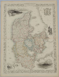
Denmark.
by TALLIS, JOHN, RAPKIN, J. AND WINKLES H
- Used
- Condition
- Used
- Quantity Available
- 1
- Seller
-
Canberra, Australian Capital Territory, Australia
- Item Price
-
A$175.00
Show Details
Description:
London & New York.: John Tallis & Company.. [Circa1850s].. Lithographed map, with original outline hand colour, 34.5 x 24.7 cm (including border and captions),five fine vignette illustrations, decorative border, central fold, edges with light toning in very good condition. Attractive decorative map with fine vignettes of Copenhagen, Sleswig and Elsinore, figures in costume, the coat of arms of Denmark and an amiable equine pair by the great mapmaker and publisher John Tallis. .
Item Price
A$175.00

Islands In The Atlantic. The Illustrations Drawn & Engraved by H. Winkles. The Map Drawn & Engraved by J. Rapkin.
by Martin, R.M.; Tallis, J. & F.; Rapkin, John; Winkles, H
- Used
- Fine
- Condition
- Used - Fine
- Quantity Available
- 1
- Seller
-
Fredericton, New Brunswick, Canada
- Item Price
-
A$193.68
Show Details
Description:
London ; New York: John Tallis & Co, 1854. Map. Fine. No Binding. map : hand col.; 23 x 23 cm.,Ancillary maps: [Azores or Western Isles] -- [Madeira. Scale ca. 1:210,000] -- [Bermudas or Summer Islands. Scale ca. 1:280,000].Includes 6 steel engraved views. Islands shown include the Azores, Madeira, Bermuda, the Canaries and the Cape Verdes. In outline color with drawings of the ports or local sites. Surrounded by a decorative border..
Item Price
A$193.68
