Click for full-size.


A.A.F. CLOTH MAP ASIATIC SERIES: No. C 52 & No. C 53. No. C 52 JAPAN & SOUTH CHI
by ARMY MAP SERVICE. [U.S.A.]
- Used
- Hardcover
Item Price
A$232.76A$209.48
Payment Methods Accepted
About This Item
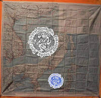
Washington D.C. 1945, Army Map Service U.S. Army. Silk map folds down to ca. 12.5 x 14.5 cm., opens up to 83.5 x 83.5 cm., color printed, 2 sides, bright, superbly clean, unused copy, as issued, two maps in all, like "NEW'. O B S C U R E . *** *** *** . . ORIGINAL WORLD WAR 2 SURVIVAL & EVASION MAP . .SHOWING A VERY LONG EAST COAST OF RUSSIA, GULF OF SAKHALIN, . . TARTARY STRAIGHT, SOUTH DOWN THE COAST, AMUR RIVER, . . VLADIVOSTOK, ALL OF MANCHURIA, KOREA, MUKDEN, HSINKING, . . DAIREN, GULF OF CHILI, BEIJING, SHANGHAI, WEIHAIWEI, . . TSINGTAU, NORTH HOKKAIDO & HONSHU, KURIL ISLANDS, AMOY, . . SWATOW, HONG KONG, MACAO, CANTON, KWANGCHOW, HAINAN, . . YUNNAN, KUNMING, GUILIN, LIUZHOU, NANNING, HANOI, DOWN . . THE COAST TO VIETNAM, LAOS, CAMBODIA, S. HONSHU, KYUSHU, . . TAIWAN, PHILIPPINES, HANGZHOU, SUCHOW, NANKING, NINGBO, . . FOOCHOW, AMOY, OKINAWA & TOO MANY OTHERS TO LIST . . SHOWING GREAT DETAILS: ROADS, RAILROADS AND RIVERS . *** U.S.A.A.F. [United States Army Air Force] issue, one on each side, one sheet = 2 maps. in all, printed in full color. . * No. C-52: JAPAN AND SOUTH CHINA SEAS. Shows Yunnan Fu [Kunming City] in the uppermost left corner at about 24.5 degrees by 103 degrees; then Kweilin [Guilin] at 110 degrees, and Amoy [Xiamen], Shanghai, Nanking [Nanjing], Foochow, and the edge of the Pescadores on the Tropic of Cancer at the north end of the map. . Includes the large operational area of the "FLYING TIGERS," "A.V.G." & the FOURTEENTH AIR FORCE in China. Including important airbase cities: Nanning, Liuzhou, Kweilin & Kunming. . * Below these areas, from the left or extreme west, Laos, Cambodia, Phnom Penh, Saigon, Hanoi [all of Indo-China] Vietnam, down to Paulau Condor [sic] [Paolo Condor] Island and the tip of Vietnam at 8 degrees. Hainan Island, Macao, Hong Kong, up the coast to Shantou. . * No. C-53: EAST CHINA SEAS: Shows Yenchowfu and Changtse upper left, Part of Korea at 35 degrees, Japan from Sendai down to Okinawa, all of Formosa, to the Philippines, Baguio, Manila all of that area, down to Albay. Including Shanghai, Nanjing, Qingdao, Hangzhou, most of the east coast of China, Taiwan & Korea. . * The large inset to the right shows Sakhalin, the Kuril Islands, Hokkaido, Northern tip of Honshu, Aomori, down to Kanazawa, Choshi at about 36 degrees. The Amur River and much of extreme eastern Russia, Vladivostok down the Pacific coast, Manchuria, Mukden, Korea, Port Arthur [Dairen], Gulf of Chili, Beijing, Paotingfu, down to Suzhou at 34 degrees. Up the coast of the Yellow Sea, Qingdao and that area. . * The back side shows the balance of the map are from the front side. From the left, Tsinan Yenchowfu, Weihaiwei, down the Yellow Sea, along the Pacific coast to Nanjing, Shanghai, Hangzhou, Ningbo, Taichofu, Wenchow, Funing fu, Lienkong, Fuzhou, Xiamen down to Yunsiaoh, across the Formosa Straits to all of Taiwan [Formosa] South to the Philippines, Bataan, the main island of Luzon, Manila, down to almost 13 degrees south ending at Sorsogon Gubat. The rest of the right [east] portion shows the Marianas Islands, Guam at the extreme lower right, the Ogasawara, Kanzan groups, with Korea at the upper middle from about 37 degrees showing all from Shunsen, Keijo [Seoul], down to Kanra San the southern island. Showing much of Japan from where the other map left off: Sakata on Honshu all of Japan, Shikoku, Kyushu, Tokara Group, the island chains Amami, Okinawa groups, Naha [Ryukyu Islands/Okinawa], down to Taiwan. . *** INSET MAPS: No. C-52: has one very large inset of N. Russia & N. Sakhalin south down to Korea Tsingtau and Chowfu. And Hokkaido, Honshu down to Urawa, 36 degrees south. . A second inset shows the key & legend to lines on the map, currents, winds, scale 1/4,000,000 or 1/4m. heights in meters, with 'Location Index" which is a key and guide to other adjacent maps in this series and this geographical area. . *** All part of the basic combat operation region for the U.S. A.A.F., U.S. Navy war against Japan. With ocean currents noted for possible air crew survival back to land. . * USED BY THE "FLYING TIGERS:" This map and many similar to it were part of the "E & E" survival items issued to "FLYING TIGER" and "A.V.G." ["AMERICAN VOLUNTEER GROUP"] pilots. They were often tied around the neck by pilots and air crew while flying combat missions. . * The map also has an Annual Magnetic Change compass, miles scale, kilometers, nautical miles [1:1,000, 000], altitudes of land mass, legend or key to symbols, roads, towns, cities, rivers, mountains and an index to boundaries. . * This map was part of the U.S. Army Air Force & Naval flyers "E & E" [Escape and Evasion] survival kit , printed on thick silk parachute cloth. These maps were often worn by fighter and other air crew members as scarves to insure they would be with the downed airman if/when his plane or he had to parachute out into the sea or over land. Each air crew member carried among other survival supplies, a .38 caliber pistol, survival knife, a signal mirror [stainless steel or glass], compass and some basic food rations, fishing kit, water purification tablets, along with minor medical supplies; the whole kit was tucked into the pant pocket of the flight suit. . * The majority of these perishable maps have been lost during World War II and very few survived the attrition of war, time, and humid climates. This map was considered the "LAST HOPE" for safe return to Allied lines. Given to fliers in the Pacific war against Japan. . *** Color photos are posted to our website. . * .
Reviews
(Log in or Create an Account first!)
Details
- Bookseller
- Rare Oriental Book Company, ABAA, ILAB - AN ART AND INTELLECTUAL PROPERTY COMPANY
 (US)
(US)
- Bookseller's Inventory #
- 38000902
- Title
- A.A.F. CLOTH MAP ASIATIC SERIES: No. C 52 & No. C 53. No. C 52 JAPAN & SOUTH CHI
- Author
- ARMY MAP SERVICE. [U.S.A.]
- Book Condition
- Used -
- Binding
- Hardcover
- Keywords
- China: Social Science, Eclectic, All Subjects & Disciplines [no Art]; Japanese Social Science, History, Law, Economics & Eclectic Item; Manchuria: All Items About This Northern Area; Maps Of Japan: Japanese/european Printed Maps & Cartography;
Terms of Sale
Rare Oriental Book Company, ABAA, ILAB - AN ART AND INTELLECTUAL PROPERTY COMPANY
Payment due upon advice of total for the book including shipping & packing charges. Shipping charges may vary from what Biblio posts vs. what the actual costs are based on the weight & size of any book, its destination and value. We reserve the right to reassess "proper and appropriate" postage on any item regardless of what Biblio suggests as the rate of postage.To the above we will also charge for packing, insurance/registry/fedex as necessary depending on destination and value at our choice. Items over $500 at our choice, will possibly be sent by Federal Express, and billed to the buyer prior to acceptance of any order. If you are unsure please inquire prior to ordering or if you disagree with the above terms please DO NOT ORDER. All sales final, returns for any item not as described is part of the Biblio requirements. Unauthorized returns will not be accepted. All books are properly collated, described prior to listing. If you have any questions please inquire BEFORE ordering. All books are professionally packed, and protected from transit damage. Please view photos posted to our website or inquire with us for more information prior to ordering. Books are not sent on approval.
About the Seller
Rare Oriental Book Company, ABAA, ILAB - AN ART AND INTELLECTUAL PROPERTY COMPANY
Biblio member since 2006
APTOS, California
About Rare Oriental Book Company, ABAA, ILAB - AN ART AND INTELLECTUAL PROPERTY COMPANY
An Art & Intellectual Property Co. Since 1967* * * * *SINCE 1967, THE PAST FIFTY-YEARS WE HAVE BEEN PURVEYORS OF FINE & RARE BOOKS ON ALL ASPECTS FAR EASTERN, ASIAN & SOUTHEAST ASIAN CULTURES, COUNTRIES & SUBJECTS.Specialties include but are not limited to: CHINA, KOREA, JAPAN, TAIWAN, SINGAPORE, VIETNAM, INDO-CHINE, CAMBODIA, LAOS, PHILIPPINES, SHANGHAI, HONG KONG, CANTON, MACAO AREAS. LAFCADIO HEARN: First Editions, Manuscripts, Collections, Obscure Items, Japanese Cirimen-bon [Crepe Paper Books], LIBRARIES PURCHASED, APPRASIAL FOR ANY REASON. MEMBERS OF THE ABAA & ILAB SINCE JUNE 1973
Glossary
Some terminology that may be used in this description includes:
- Cloth
- "Cloth-bound" generally refers to a hardcover book with cloth covering the outside of the book covers. The cloth is stretched...

What is a professional bookseller?
Just about anyone can sell a book, but a professional bookseller knows the ins and outs of the rare book trade. Learn more!

Michael Bond - the man behind Paddington Bear
“All the same ... it’s a very important name. And I don’t expect there are many bears in the world called Paddington!”
A lonely toy bear on an empty shop shelf on Christmas Eve in 1956 first captured the attention of Michael Bond, who kindly shared Paddington with the world.