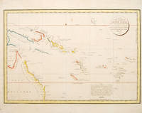
CARTE D'UNE PARTIE DU GRAND OCEAN a l'E et S.E. de la Nouvelle Guinee pour l'intelligence do Voyage de la Fregate Espagnole la Princessa commandee par D.Franco. Antonio Maurelle. en 1781: Plate no.68.
by LA PEROUSE, Jean Francois de Galaup
- Used
- Condition
- See description
- Seller
-
London, United Kingdom
Payment Methods Accepted
About This Item
Atlas du Voyage de la Perouse., [c.1785]. Interesting chart of part of the south-western Pacific, showing the routes taken by the Spanish explorer Don Francisco Antonio Maurelle in 1781 along the northern coast of New Guinea and across the Pacific to Fiji and Tonga. Maurelle was credited with the discovery of the Hermit Islands on this voyage. The map includes the north-eastern coast of Australia, and parts of the coast of New Guinea. The map shows the 1781 route of his ship "The Princesa" through the Bismarck Archipelago north of New Guinea, through the Archipel de Salomos [i.e. Solomon Islands] and then east across the Pacific to the Iles de Amis [i.e. the Friendly Islands, now Tonga] where he discovered I. Vavao [ i.e. Vava'u] with one of the best anchorages in the South Pacific. The map includes the Iles de Navigateurs [i.e. Samoa], I. Fidji [i.e. Fiji], Iles de Esprit [i.e. Vanuatu or the New Hebrides Isles], and Nouvelle Caledonie [i.e. New Caledonia]. Many small islands are depicted with notes regarding their sightings by Abel Tasman, William Bligh and Maurelle. A note on the chart states that the publisher has placed the islands according to the longitude of other navigators, rather than on Maurelle's figures which were considered estimates only, and also, that Maurelles chart was based on a French chart by Jacques Nicolas Bellin published in 1742. The French cartographers at the time did not consider the Spanish charts to be sufficiently accurate, so they preferred to make their own corrections. Copper engraving. Later colour. Good condition. One light and one dark spot of foxing to the upper centre. A slight, faint watermark. Size: 49 x 34 cm. (19½ x 13½ inches)
Reviews
(Log in or Create an Account first!)
Details
- Bookseller
- Peter Harrington
 (GB)
(GB)
- Bookseller's Inventory #
- 53439
- Title
- CARTE D'UNE PARTIE DU GRAND OCEAN a l'E et S.E. de la Nouvelle Guinee pour l'intelligence do Voyage de la Fregate Espagnole la Princessa commandee par D.Franco. Antonio Maurelle. en 1781
- Author
- LA PEROUSE, Jean Francois de Galaup
- Book Condition
- Used
- Place of Publication
- Atlas du Voyage de la Perouse.
- Date Published
- [c.1785]
Terms of Sale
Peter Harrington
All major credit cards are accepted. Both UK pounds and US dollars (exchange rate to be agreed) accepted. Books may be returned within 14 days of receipt for any reason, please notify first of returned goods.
About the Seller
Peter Harrington
Biblio member since 2006
London
About Peter Harrington
Since its establishment, Peter Harrington has specialised in sourcing, selling and buying the finest quality original first editions, signed, rare and antiquarian books, fine bindings and library sets. Peter Harrington first began selling rare books from the Chelsea Antiques Market on London's King's Road. For the past twenty years the business has been run by Pom Harrington, Peter's son.
Glossary
Some terminology that may be used in this description includes:
- New
- A new book is a book previously not circulated to a buyer. Although a new book is typically free of any faults or defects, "new"...

Collecting Nebula Award Winners of the 1980s
The Nebula Award has been awarded to stories in the Science Fiction and Fantasy genre every year since 1966. Learn about the winners of the 1980s!

Collecting History of the Circus in America
Step right up! Take a look at the center ring, where you will see displayed the most amazing, most colorful series of history books that the world has ever seen! Right this way, folks…
