Description:
New.
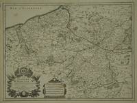
Carte Nouvelle du Duché de Mantoue Leyée par ordre Exprés. á L´Usage des Armées en Italie; ou sont Exactement Marqués les Grands Chemins, les Routes des Imperiaux &c. Par le Sr. Sanson. Geograp. du Roy á Amsterdam Chez P. Mortier Avec Privil. by Sanson, Nicolas dAbbeville - 1693-1700
by Sanson, Nicolas dAbbeville
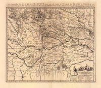
Carte Nouvelle du Duché de Mantoue Leyée par ordre Exprés. á L´Usage des Armées en Italie; ou sont Exactement Marqués les Grands Chemins, les Routes des Imperiaux &c. Par le Sr. Sanson. Geograp. du Roy á Amsterdam Chez P. Mortier Avec Privil.
by Sanson, Nicolas dAbbeville
- Used
Amsterdam: Pierre Mortier, 1693-1700. Other. 490 by 580mm (19¼ by 22¾ inches).. Copper engraving, uncolored as published. Large detailed and interesting map by the famous French cartographer Nicolaus Sanson published in the famous sea atlas Le Neptune francois... in Amsterdam at Pierre Mortier. This interesting and large map was originally first published in the Atlas Noveau... by Alexis Hubert Jaillot & N. Sanson in Paris 1683-89. Alexis Hubert Jaillot & Nicolaus Jaillot worked as a royal cartographers for the French royal house for king Louis XIV. His maps published for the Atlas Nouveau... can be regarded as masterpieces of cartography in France in the ending 18th century. Also the maps impress by their accuracy and are providing an enormous amount of place names, monasteries, rivers, trails, fortifications, etc. Shown is the duchy of Mantua (Mantova) in Northern Italy. Mantua is shown prominently in the center of the map. The map provides many place names, detailed information on the river system also in the lower right corner a cartouche with a mileage scale and a table of explanations. A strong impression in excellent condition. 490 by 580mm (19¼ by 22¾ inches).
-
Bookseller
Antiquariat Reinhold Berg ek
 (DE)
(DE)
- Format/Binding Other
- Book Condition Used
- Quantity Available 1
- Publisher Pierre Mortier
- Place of Publication Amsterdam
- Date Published 1693-1700
- Keywords Antique map Map:Europe:Italy Mantua Sanson, Nicolas dAbbeville Carte Nouvelle du Duché de Mantoue Leyée par ordre Exprés. á L´Usage des Armées en Italie; ou sont Exactement Marqués les Grands Chemins, les Routes des Imperiaux &c. Par le Sr.
- Product_type map
- Size 490 by 580mm (19¼ by 22¾ inches).

Introduction A La Geographie, Ou Font La Geographie Astronomique, Qui Explique La Correspondence Du Globe Terrestre Avec La Sphere. La Geographie Naturelle, ... La Geographie Historique
by Nicolas Sanson D'Abbeville
- New
- Condition
- New
- ISBN 10 / ISBN 13
- 9780461191400 / 0461191407
- Quantity Available
- 10
- Seller
-
Southport, Merseyside, United Kingdom
- Item Price
-
A$36.19
Show Details
Item Price
A$36.19
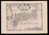
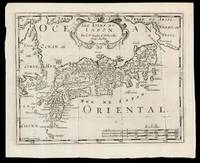
De Eilanden van Japan: Halma's Dutch edition of Sanson's map of Japan
by SANSON D'ABBEVILLE, Nicolas (I) and HALMA, Francois
- Used
- Condition
- Used
- Quantity Available
- 1
- Seller
-
London, United Kingdom
- Item Price
-
A$77.53
Show Details
Description:
[Amsterdam,: Francois Halma,, 1705].. 221 by 311mm. (8.75 by 12.25 inches).. Engraved map. Third state of the plate, first published in Halma's pirated edition of Sanson's 'L'Asie en plvsiers cartes nouvelles, et exactes;
', as part of 'L'Europe; L'Asie; L'Amerique
en Pluiers Cartes', 1683. A direct copy of Sanson's map of 1652, the only differences being the lack of a privilege and a date in the cartouche, the addition of the signature of the engraver, Antoine de Winter in the lower left corner. This issue was published in Halma's Dutch edition, 'Algemeene Wereldbeschryving
' in 1705 and is distinguished by the change of the title from French into Dutch. Francois Halma (1653-1722) set up his printing business in Utrecht in 1674, where he issued a number of pirated maps and atlases. In this instance, since Sanson was dead, Halma may have felt that there no harm and much profit to be gained from re-printing his work. The engraver, Antoine de Winter (c1652-1700) achieved some notoriety for…
Read More Item Price
A$77.53
More Photos
"Partie de la Barbarie ou est le Royaume d'Alger divise en les Provinces. Parie du Biledulgerid." (Map of Northern Africa). Attractive and detailed coastal map of North Africa with Algeria. Antique Engraved Hand-Coloured Map.
by Sanson d'Abbeville, Nicolas
- Used
- Condition
- Used
- Quantity Available
- 1
- Seller
-
Dorchester, Dorset, United Kingdom
- Item Price
-
A$106.60
Show Details
Description:
Paris Sanson d'Abbeville, Nicolas Ca 1660. In ivory mount. Mount size (16 x 13.5 inches) 40.5cm x 35cm Engraved size 28cm x 22cm (11 x 8.5 inches) In very good condition. Laid Down.
Item Price
A$106.60
Diocese du Mans Divisee Par Doyennes Ruraux.
by SANSON D'ABBEVILLE, N[icolas]
- Used
- Condition
- Used
- Quantity Available
- 1
- Seller
-
London, London, United Kingdom
- Item Price
-
A$145.36
Show Details
Description:
Paris: Pierre Mariette. [c. 1658]. 37.4 x 49.5 cm. Original outline colour. Double page map of Maine, northern France. Title cartouche to lower left corner, dedication cartouche to Christophe de Justel to upper right corner with the coat of arms of his family. Blank on verso. Small tears without loss to left and lower margins. Light stains to lower margin, otherwise in good condition.
Item Price
A$145.36
La Flandre Fran�oise, ...
by JAILLOT, [Alexis] H[ubert]. [After] SANSON, [Nicolas d'Abbeville]
- Used
- Condition
- Used
- Quantity Available
- 1
- Seller
-
London, London, United Kingdom
- Item Price
-
A$242.27
Show Details
Description:
Paris: Jaillot. 1689. 43.1 x 57 cm. Original outline colour. Single page folio map of southern Flanders and Artois. Blank on verso. Small tear without loss at upper edge just touching image. Small section of upper margin missing though not affecting map. Small brown spot to centre of lower edge.
Item Price
A$242.27
Anciens Royaumes De Kent, D'Essex, et De Sussex ou sont Aujourdhuy les Comt�s Kent, D'Essex, Middlessex, Et Hartford De Sussex, Et Surrey. Avecq le Pas De Calais, et Partie des Costes du Pays Bas, de Picardie, et Normandie.
by SANSON [D'ABBEVILLE, Nicolas]
- Used
- Condition
- Used
- Quantity Available
- 1
- Seller
-
London, London, United Kingdom
- Item Price
-
A$242.27
Show Details
Description:
Paris: (Sanson). 1654. 36.6 x 48 cm. Original outline colour. Double page map of the south east England shown with the adjacent coastline of France and Belgium. Title cartouche to lower right corner. Blank on verso. Wear to centrefold with some small holes.
Item Price
A$242.27
Le Limbourg ou sont Le Duche De Limbourg Le Comt� De Dalem; Les Seigneuries De Fauquemont, Et De Rolduc ...
by JAILLOT, [Alexis] H[ubert]. [After] SANSON, [Nicolas d'Abbeville]
- Used
- Condition
- Used
- Quantity Available
- 1
- Seller
-
London, London, United Kingdom
- Item Price
-
A$290.73
Show Details
Description:
Paris: Jaillot. 1681. 43 x 57 cm. Original outline colour. Single page folio map of Limborg and its envirions. Blank on verso. Small tear with loss to upper right margin. Some light stains at right margin though not affecting image, otherwise in very good condition.
Item Price
A$290.73
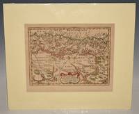
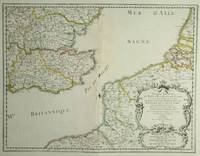
Les Isles dv Iapon: Second state of Halma's pirated edition of Sanson's map of Japan
by SANSON D'ABBEVILLE, Nicolas (I) and HALMA, Francois
- Used
- Condition
- Used
- Quantity Available
- 1
- Seller
-
London, United Kingdom
- Item Price
-
A$290.73
Show Details
Description:
[Amsterdam,: Chez Arnout van Ravenstein,, 1699].. 222 by 272mm. (8.75 by 10.75 inches).. Engraved map. Second state of the plate, first published in Halma's pirated edition of Sanson's 'L'Asie en plvsiers cartes nouvelles, et exactes;
', as part of 'L'Europe; L'Asie; L'Amerique
en Pluiers Cartes', 1683. A direct copy of Sanson's map of 1652, the only differences being the lack of a privilege and a date in the cartouche, the addition of the signature of the engraver, Antoine de Winter in the lower left corner. This issue is distinguished by the addition of mountains added in 'Isle de Corey' and 'Terre de Iesso'; and the 'Mer de Japan' above 'Oriental'. Francois Halma (1653-1722) set up his printing business in Utrecht in 1674, where he issued a number of pirated maps and atlases. In this instance, since Sanson was dead, Halma may have felt that there no harm and much profit to be gained from re-printing his work. The engraver, Antoine de Winter (c1652-1700) achieved some notoriety for plagiarizing…
Read More Item Price
A$290.73

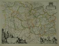
Le Royaume De Danemark Subdivis� en ses Principales Provinces, Tire de Plusieurs Memoires.
by JAILLOT, [Alexis] Hubert. [After] SANSON, [Nicolas d'Abbeville]
- Used
- Condition
- Used
- Quantity Available
- 1
- Seller
-
London, London, United Kingdom
- Item Price
-
A$484.55
Show Details
Description:
Paris: Jaillot. 1685. 54.6 x 88.4 cm. Original outline colour. Large double page map of Denmark. Blank on verso. Minor creasing to left of centrefold, otherwise in very good condition.
Item Price
A$484.55

Insularum Iaponiae: A German copy of Sanson's map in VII Partes divisa & LXVI Regna Antiqua divise per N Sanson.
by ZUNNER, Johann David after SANSON D'ABBEVILLE, Nicolas (I)
- Used
- Condition
- Used
- Quantity Available
- 1
- Seller
-
London, United Kingdom
- Item Price
-
A$581.46
Show Details
Description:
[Frankfurt,: Johann David Zunner, , 1679].. 233 by 302mm. (9.25 by 12 inches).. Engraved map. Johann David Zunner's version of Nicolas Sanson d'Abbeville's map of Japan. The map was produced by Zunner for his 'Die gantze Erd=Kugel, Bestehend In den vier bekannten Theilen der Welt, Als Europa, Asia, Africa und America' (1679). It is a faithful copy of Sanson's map from 'L'Asie en plusiers cartes nouvelles, et exactes'. Zunner gives full credit to Sanson on the title-page and on the map. Johann David Zunner (1641-1704) was a German publisher active in Frankfurt. Hubbard 42.
Item Price
A$581.46
