
Click for full-size.
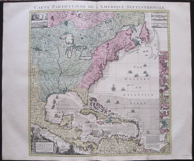
Carte Particulére de Amerique Septrionale. A Map of the British Empire In America with the French, Spanish and the Dutch Settlements adjacent thereto by Henry Popple.
by Popple, Henry; Covens, Jean & Mortier, Corneille
- Used
- Signed
- Condition
- See description
- Seller
-
Nafplion, Greece
Payment Methods Accepted
About This Item
Americas: Amsterdam. Covens et Mortier c1741. Copper engraved map from Covens & Mortier's " Nieuwe Atlas, Inhoudennde vier Gedeeltens der Waereld.. " Original full wash colour; verso blank. Covens and Mortier edition of the key sheet to Popple's 20 sheet map with inset views of New York, Quebec, Mexico City and the Niagara Falls [black& white as issued] 18 coloured inset plans of ports and islands.[ see item 3062] Black & white title cartouche as issued. To lower right corner is the "the Approbation of the Right Honourable the Lords Commissioners of Trade and Plantations," Popple's map had quasi-official status, and a copy was sent to each of the governments of each of the colonies and the approbation of Edmund Halley: "I have seen the abovementioned Map, which as far as I am Judge, seems to have been laid down with great Accuracy, and to shew the Position of the different Provinces & Islands in that Part of the Globe more truly than any yet extant." Popple's famous map on 20 sheets appeared 1733 Popple drew on many sources: the maps of Guillaume De L'Isle and Nicholas de Fer; John Barnwell's manuscript map of the south-eastern colonies of circa 1721 which included up-to-date information on the Indian settlements in the interior; and Cadwallader Colden's famous Map of the Country of the Five Nations. In all, it covers from the Grand Banks off Newfoundland to about ten degrees west of Lake Superior, and from the Great Lakes to the north coast of South America. Several of the sections are illustrated with pictorial insets, including views of New York City, Niagara Falls, Mexico City, and Quebec, and inset maps of Boston, Charles-Town, Providence and Bermuda. Benjamin Franklin ordered two of the original map for the Pennsylvania Assembly on 22 May 1746, "one bound and the other in sheets." One of these was hanging in the Pennsylvania State House when the Declaration of Independence was signed on July 4th, 1776. John Adams noted that Popple's map was "the largest I ever saw, and the most distinct." Copies were found in the private collections of several of the wealthier founding fathers, including George Washington. Dark impression; bright full wash colour; printed on heavy paper; light soiling; old red crayon numbers to verso. Covens & Mortier as a firm existed between 1721-1778, taking over the business of Pierrre Mortier. Johannes / Jean Covens and Cornelius Mortier were brothers- in- law following the former's marriage to Mortier's sister Agatha in 1721, when they also formally went in to partnership. Under the Covens and Mortier imprint, Cornelius and Jean republished the works of the great 17th and early 18th century Dutch and French cartographers De L'Isle, Allard, Jansson, & De Wit. The firm would become one of the most prolific Dutch publishing concerns of the 18th century. The company would pass down through the Covens family as Mortier had no children, changing the name to Covens & Zoon until Pieter Mortier IV a great grandson of the original founder joined the firm and saw the name restored to Mortier Covens & Zoon. ( See Koeman I p45). Henry Popple (16?? - 1743) was a British cartographer active in the early part of the 18th century. Popple was a clerk with the Board of Trade and Plantations, the organization that governed Britain's colonies in America. With his father, grandfather, and brother all being employed the board of trade, the Popple family had a long history of association with the British colonial administration. Popple received his commission as a clerk at the board of trade in 1727, but resigned in the same year to take a position as the Cashier to Queen Anne. In 1730, the Board began requesting detailed maps of the entirety of the provinces and contiguous French and Spanish Dominions. Popple had begun work on the map in 1727. He continued to work on his great maps and a manuscript version of the Popple Map appeared in this very year. Popple issued an announcement for the map in 1731, but did not complete work until 1733. as he continued to update and refine the map. The Board of trade intended the Popple map to be a British response to Delisle's French mapping of North America, which presented boundaries that conflicted with British colonial ambitions. However, since Popple in fact based much of his map on Delisle's superior cartography, he also managed to copy many of the French political boundaries - to the detriment of the Board of Trade and its expansionist intentions. Although Popple's map was never approved by the Board, examples were rushed to each colonial governor and the map played a significant role in the cartographic history of North America. Popple cartographic endeavor began and ended with this singular map however, it significance was such that he must be considered in any list of significant British mapmakers. The large scale map was not a commercial success and did not sell well until after William Henry Toms and Samuel Harding took over publication in 1739. With the outbreak of the War of Jenkin's Ear, the map saw its commercial successes soar. In 1746, the rights to the map passed to Willdey and Austen, who published it until Austen's death in 1750. Various other printers produced versions of the map in smaller format of which the Covens and Mortier version is undoubtedly the most fine. Koeman I: C&M 8:106; Americas North America Amerique Septrionale Henry Popple British Empire in America
Reviews
(Log in or Create an Account first!)
Details
- Seller
- Mary Louise Bryan/Paralos Gallery
 (GR)
(GR)
- Seller's Inventory #
- 3060
- Title
- Carte Particulére de Amerique Septrionale. A Map of the British Empire In America with the French, Spanish and the Dutch Settlements adjacent thereto by Henry Popple.
- Author
- Popple, Henry; Covens, Jean & Mortier, Corneille
- Book Condition
- Used
- Publisher
- Amsterdam. Covens et Mortier c1741
- Place of Publication
- Americas
Terms of Sale
Mary Louise Bryan/Paralos Gallery
30 day return guarantee, with full refund including original shipping costs for up to 30 days after delivery if an item arrives misdescribed or damaged.
About the Seller
Mary Louise Bryan/Paralos Gallery
Biblio member since 2013
Nafplion
About Mary Louise Bryan/Paralos Gallery
Dealer in Antiquarian Maps Prints & Books with over 35 years experience.
Retail Shop in Historic centre of Nafplion Greece see hours; Internet site and private office by appointment only; Exhibiter at London Map Fair and at fairs around Europe. Member of the Antiquarian Booksellers Association & ILAB
Retail Shop in Historic centre of Nafplion Greece see hours; Internet site and private office by appointment only; Exhibiter at London Map Fair and at fairs around Europe. Member of the Antiquarian Booksellers Association & ILAB
Glossary
Some terminology that may be used in this description includes:
- Fine
- A book in fine condition exhibits no flaws. A fine condition book closely approaches As New condition, but may lack the...
- A.N.
- The book is pristine and free of any defects, in the same condition as ...
- New
- A new book is a book previously not circulated to a buyer. Although a new book is typically free of any faults or defects, "new"...
- Verso
- The page bound on the left side of a book, opposite to the recto page.
Frequently asked questions
This Book’s Categories

Collecting Disneyana
Welcome to the wonderful world of collecting Walt Disney! From letters signed by Disney himself to classic children’s books or ephemera, be sure to check out some of the collectible Walt Disney books on Biblio!

Collecting Arkham House
Learn about collecting the iconic horror and fantasy publisher that produced books by the likes of Ray Bradbury, August Derleth and H. P. Lovecraft.
