
Click for full-size.
Carte plate de l'Ile Necker.
by LA PÉROUSE, Jean Francois de Galaup
- Used
- Condition
- See description
- Seller
-
London, United Kingdom
Payment Methods Accepted
About This Item
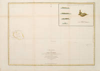
Paris:, 1797. From the Voyages of La Pérouse who set sail from France in 1785 to continue the discoveries of Captain Cook. He was shipwrecked in 1788 but his narrative, maps, and views survived and were published in 1797. Sea chart showing Necker Island, a small island in the Pacific Ocean, part of the Nortwestern Hawaiian Islands. La Perouse was the first European to visit the island, in 1786. Map inset in the right top corner showing profiles of the island from different angles. Atlas Du Voyage De La Pérouse. Size: 680 x 485 mm. Copper engraving. Hand coloured. Very good condition. Faint waterstain to the left vertical fold. Good margins. Watermarks. Folds as issued.
Reviews
(Log in or Create an Account first!)
Details
- Bookseller
- Peter Harrington
 (GB)
(GB)
- Bookseller's Inventory #
- 55873
- Title
- Carte plate de l'Ile Necker.
- Author
- LA PÉROUSE, Jean Francois de Galaup
- Book Condition
- Used
- Place of Publication
- Paris:
- Date Published
- 1797
Terms of Sale
Peter Harrington
All major credit cards are accepted. Both UK pounds and US dollars (exchange rate to be agreed) accepted. Books may be returned within 14 days of receipt for any reason, please notify first of returned goods.
About the Seller
Peter Harrington
Biblio member since 2006
London
About Peter Harrington
Since its establishment, Peter Harrington has specialised in sourcing, selling and buying the finest quality original first editions, signed, rare and antiquarian books, fine bindings and library sets. Peter Harrington first began selling rare books from the Chelsea Antiques Market on London's King's Road. For the past twenty years the business has been run by Pom Harrington, Peter's son.

Collecting Little Golden Books
These iconic childrens board books are collectible if you can find an original in great condition! Learn more about collecting Little Golden Books.

RIP (Please) George Romero: Modern Master of Zombie Horror
George Romero co-wrote and directed Night of the Living Dead in 1968, a film that inspired the modern zombie craze and made an indelible mark on American cinema. Come this way, horror fan...
