
Click for full-size.
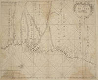
A CHART OF YE COAST OF ANGOLA FROM YE R. AMBRIS TO MOUNT NEGRO
by Mount, William, Page, Thomas
- Used
- Condition
- See description
- Seller
-
Port Hope, Ontario, Canada
Payment Methods Accepted
About This Item
London: : From "The English Pilot: Part V" Sixth edition. Mount and Page, , 1761. 16-3/4" x 20-1/2"- 42.5 x 52 cm. Copper engraved map with hand colouring. Light overall browning with darker areas to corners, generally good . An interesting coastal chart engraved by Francis Lamb showing rhumb lines, from the Congo to Mount Negro in Mataman (now Namibia).
Reviews
(Log in or Create an Account first!)
Details
- Seller
- Webster's Fine Books & Maps, ABAC, ILAB
 (CA)
(CA)
- Seller's Inventory #
- 1386
- Title
- A CHART OF YE COAST OF ANGOLA FROM YE R. AMBRIS TO MOUNT NEGRO
- Author
- Mount, William, Page, Thomas
- Book Condition
- Used
- Quantity Available
- 1
- Publisher
- From "The English Pilot: Part V" Sixth edition. Mount and Page,
- Place of Publication
- London:
- Date Published
- 1761
- Weight
- 0.00 lbs
- Bookseller catalogs
- Antiquarian Map-Africa;
Terms of Sale
Webster's Fine Books & Maps, ABAC, ILAB
All items guaranteed as catalogued. We accept Visa, US$, Sterling or C$ cheques, international or postal money orders. Returns if notified within 7 days of receipt and items must be returned in condition they were received.
About the Seller
Webster's Fine Books & Maps, ABAC, ILAB
Biblio member since 2004
Port Hope, Ontario
About Webster's Fine Books & Maps, ABAC, ILAB
Webster's Fine Books & Maps are members of the Antiquarian Booksellers Association of Canada (ABAC),The International League of Antiquarian Booksellers (ILAB) and International Map Collectors Society (IMCoS) . We deal in Books on travel and antiquarian & maps of all geographical areas but particularly of North America and of Islands. We welcome want lists and can provide appraisals for probate or insurance purposes.
This Book’s Categories

A Brief History of the Dust Jacket
When did dust jackets first appear, and what exactly are they for? Learn about this often-important detail as it applies to book collecting. More...

Collecting Arkham House
Learn about collecting the iconic horror and fantasy publisher that produced books by the likes of Ray Bradbury, August Derleth and H. P. Lovecraft.
