
Click for full-size.
A French Wall Map of the Western Hemisphere
by GASPARD BAILLEUL
- Used
- Very Good
- Condition
- Very Good
- Seller
-
White Plains, New York, United States
Payment Methods Accepted
About This Item
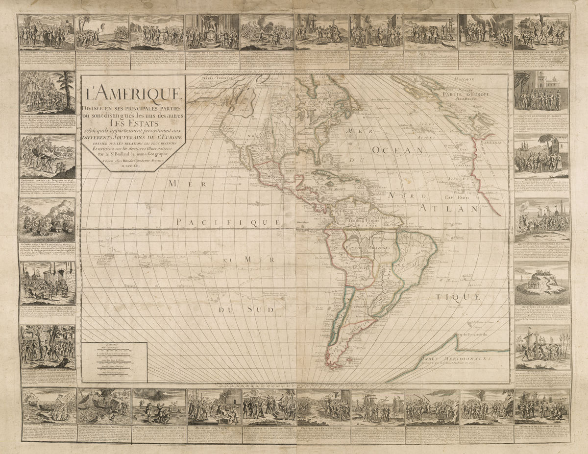
Lyon, France, 1752. No binding. Very Good. Map. L'Amerique Divisee en ses Pricipales Parties ou sont distingues les ud de autres les Estats, selon quils appartiennents presentement aux Differents Souverains De L'Europe . . . Par le Sr. Bailleul le jeune Geographe. Jean Louis Daudet, Lyon, France, 1752. Approximately 31 x 40 in., on original wooden rollers. Historical BackgroundJean Louis Daudet, a Lyonnais map and book seller, published this map of the known states and territories of the New World created by Gaspard Bailleul, a noted Parisian geographer, and his son. Unsurprisingly, the Caribbean, Eastern Seaboard, and California coasts are the most detailed and accurate, while the extremities north, south, and inland are less detailed, leading to some interesting cartographic fables. Bailleul's view of the Northwest Coast of America, includes the early appearance of the fabled ""Mare de L'Ouest"" (Sea of the West) and ""Presque Isle de Nord Ouest"" (Peninsula of the Northwest) in the areas of present-day British Columbia and points north.Perhaps most remarkable is the presence of huge continent, ""Indes Meridionales,"" (Southern Indies) in the South Atlantic Ocean. Bailleul labels it""Decouverte par le Sr. Binot Paulmier en 1503."" referring to a widely-held belief that Binot Paulmier, an early 16th century French explorer, was thought to have discovered ""Terra Australis."" In 1503, Paulmier sailed for the East Indies but was blown off course by a storm. In 1505, he returned claiming to have discovered a ""great Austral land"" that he also called ""Indies Meridionale."" Despite his claims, as well as renewed interest a century later, Paulmier had made landfall on the coast of Brazil. Bailleul's map provides one of the largest and most ambitious depictions of the unknown southern continent by French geographers and historians.Bordered by 30 vignettes illustrating scenes from European discovery and colonization such as the Conquests of Peru and Mexico, the Discovery of America, Taking Possession of New France, Native Peoples of the North, and many others. Bailleul also provides the journeys of early explorers and circumnavigators. One such site, Drake's Beach, (""P.te de Drack"" ) in present-day northern California, is the location where of Sir Francis Drake overhauled his ships before crossing the Pacific Ocean on his circumnavigation.Condition Very good, original rollers, laid down on modern linen. Minor tears and abrasions.
Reviews
(Log in or Create an Account first!)
Details
- Seller
- Seth Kaller, Inc.
 (US)
(US)
- Seller's Inventory #
- 22142
- Title
- A French Wall Map of the Western Hemisphere
- Author
- GASPARD BAILLEUL
- Format/Binding
- No binding
- Book Condition
- Used - Very Good
- Quantity Available
- 1
- Place of Publication
- Lyon, France
- Date Published
- 1752
- Weight
- 0.00 lbs
- Keywords
- 22142, gaspard bailleul, jean louis daudet,
- Bookseller catalogs
- Maps;
- Product_type
- Map
Terms of Sale
Seth Kaller, Inc.
30 day return guarantee, with full refund including shipping costs for up to 30 days after delivery if an item arrives misdescribed or damaged. Authenticity guaranteed for the life of the book or document.
About the Seller
Seth Kaller, Inc.
Biblio member since 2006
White Plains, New York
About Seth Kaller, Inc.
Seth Kaller is a leading expert in acquiring, authenticating, and appraising important American historic documents and artifacts. Kaller has built museum-quality collections for individuals and institutions, as well as legacy philanthropic collections. Showings by appointment.
Glossary
Some terminology that may be used in this description includes:
- New
- A new book is a book previously not circulated to a buyer. Although a new book is typically free of any faults or defects, "new"...

The Great Formosa Hoax
George Psalmanazar played a grand prank in 1703, pretending to be a resident of the island of Formosa. His book took London by storm. Learn more...

Bob Dylan - 2016 Winner of the Nobel Prize for Literature
From the first screech of his electric guitar upsetting musicians at a folk festival to his writing and paintings, Bob Dylan has risen to become a seminal force in American popular culture. In 2016, he was recognized by the Nobel Committee. Learn more about his creations...