Description:
Bouquins, 2022. Paperback. Very Good. Slight signs of wear on the cover. Ammareal gives back up to 15% of this item's net price to charity organizations.
Geographia Synodica, Sive regionum urbium, et locorum ubi celebrata sunt concilia oecumenica, nationalia, provincialia et synodi dioece sanae; Tabula geographia prima, quae tottus orbis partes continet. Ex Conatibus Geographicis Gulielmi Sanson Nicolai Filii Christianissimi Galliarum Regis Geographi. by Sanson, Guillaume - 1667
by Sanson, Guillaume
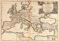
Geographia Synodica, Sive regionum urbium, et locorum ubi celebrata sunt concilia oecumenica, nationalia, provincialia et synodi dioece sanae; Tabula geographia prima, quae tottus orbis partes continet. Ex Conatibus Geographicis Gulielmi Sanson Nicolai Filii Christianissimi Galliarum Regis Geographi.
by Sanson, Guillaume
- Used
Paris: P. Mariette, 1667. Other. 395 by 565mm (15½ by 22¼ inches).. Copper engraving, hand colored in outline when published. A decorative historical map of Europe in original outline color, showing the place names, where Church councils and Synods have been held. Further on the map shows other interesting historical place names, rivers and mountains, also political borders. Decorated with an engraved allegoric title cartouche showing a catholic church council in session. The map covers all of Europe, the Mediterranean and northern Africa. It extends to the eastern Mediterranean with Cyprus and Syria. Guillaume Sanson (1633-1703) was a well known French cartographer. He was the son of Nicolas Sanson. After his father's death in 1667 he worked together with his brother Hubert Jaillot.
The centre fold minor spotting, else in excellent condition.
-
Bookseller
Antiquariat Reinhold Berg ek
 (DE)
(DE)
- Format/Binding Other
- Book Condition Used
- Quantity Available 1
- Publisher P. Mariette
- Place of Publication Paris
- Date Published 1667
- Keywords Antique map Map:Europe:Europe Sanson, Guillaume Geographia Synodica, Sive regionum urbium, et locorum ubi celebrata sunt concilia oecumenica, nationalia, provincialia et synodi dioece sanae; Tabula geographia prima, quae tottus orbis partes continet. Ex
- Product_type map
- Size 395 by 565mm (15½ by 22¼ inches).

L'âme humaine
by Stefan Zweig, Bertrand Dermoncourt, David Sanson et Guillaume Ollendorff
- Used
- very good
- Paperback
- Condition
- Used - Very Good
- Binding
- Paperback
- ISBN 10 / ISBN 13
- 9782382922439 / 2382922435
- Quantity Available
- 1
- Seller
-
Morangis, France
- Item Price
-
A$12.10
Show Details
Item Price
A$12.10
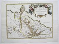
Cimmeria quae Postea Scythia Europaea Seu Parua Scythia
by SANSON, Guillaume
- Used
- very good
- Condition
- Used - Very Good
- Quantity Available
- 1
- Seller
-
Kraków, Poland
- Item Price
-
A$227.64
Show Details
Description:
Paris: Pierre Mariette, 1665 Copper engraving on paper 405 x 503 mm, colored in outline, trimmed on or just inside the plate mark, and pasted on strong paper 480 x 610 mm (paper slightly creased at verso, remnants of cenrefold). "Cimmeria, which later became European Scythia or Lesser Scythia." A good copy of a geographical exercise by Guillaume Sanson (1633-1703). He was the son of the celebrated French cartographer Nicolas Sanson (1600-1667), and inherited the family firm along with his brother Adrien Sanson (1639-1718) upon their father's demise. The map, drawing from classical authors, depicts Cimmeria (an ancient name of Crimea) and Scythia (now the southern Ukraine). It was included in the atlas "Cartes generales de toutes les parties du monde" printed in Paris by Pierre Mariette in 1665. Pastoureau, Sanson V B (160).
Item Price
A$227.64
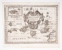
Isles Canaries
by SANSON D'ABBEVILLE, Guillaume
- Used
- Condition
- Used
- Quantity Available
- 1
- Seller
-
London, London, United Kingdom
- Item Price
-
A$533.00
Show Details
Description:
[c.1700]. Original engraved map (19 x26.5 cm. , overall sheet size 22 x 29 cm.) of the Canaries with inset of Madeira. Central vertical fold.
Item Price
A$533.00

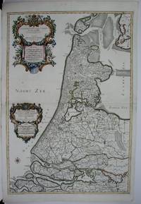
Partie Septentrionale du Comte de Hollande...
by Sanson, Guillaume (1633-1703)
- Used
- Condition
- Used
- Quantity Available
- 1
- Seller
-
Lisse, Netherlands
- Item Price
-
A$668.15
Show Details
Description:
Map of North Holland, with Tessel island. Large cartouche on the left with title, dedication and explanation concerning the scales adopted for this map. The title is printed from a different plate. Titled: 'PARTIE SEPTENTIONALE DU COMTÉ DE / HOLLANDE. / Dressée sur les Memoires les plus Nouveaux. / Par le S.r SANSON, Geographe ordinaire du Roy.' // 'Presenté A MONSEIGNEUR LE DAUPHIN, / Par son tres-humple, tres-Obeissant, et tres fidele Serviteur / Alexis Hubert Iaillot.' On the bottom of the scales: 'A Paris chez H. Iallot joignant kes grands Augustins, aux deux Globes. / Avec Privilege du Roy pour Vingt Ans. / 1699', last number '9'in pen and brown ink. In fact the original plate does not show the last number, which was supposed to be added in a second moment. l Etching and engraving on paper, trimmed to plate mark, partially hand coloured; total: 431 x 564 mm; pasted on thick paper, some losses of paper, some stains, corners with pinholes and further damages. Folding line in the middle, top part…
Read More Item Price
A$668.15
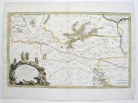
Paphlagonia Heroicis Temporibus Henetorum Populorum Sede Clara; cujus Paphlagonia Maritima suit Romanorum Aetate Ponti Regni Pars Occidentalior, In qua Sinope totius Mithridatis Regni caput. Paphlagonia vero Mediterranea Pylaemenis Regnum constituit.
by Sanson, Guillaume
- Used
- Condition
- Used - Excellent
- Quantity Available
- 1
- Seller
-
Toronto, Ontario, Canada
- Item Price
-
A$890.91
Show Details
Description:
Paris: Mariette, Pierre, 1678. Excellent. Size : 390x522 (mm), 15.375x20.5 (Inches), Coloring: Original Outline, with later cartouche coloring, Category: ; Maps Asia Near East Turkey
Item Price
A$890.91
Galatia cujus Populi Tolistobogi, Tectosages, Trocmi, mox Provinncia sub Romanis in Primam et Secvndam divisa et in ea Romana Itineraria ex Tabula Peutingeriana et ex Antonio descripta
by Sanson, Guillaume
- Used
- Condition
- Used - Excellent
- Quantity Available
- 1
- Seller
-
Toronto, Ontario, Canada
- Item Price
-
A$890.91
Show Details
Description:
Paris: Mariette, Pierre, 1678. Excellent. Size : 357x595 (mm), 14x23.375 (Inches), Coloring: Original Outline, with later cartouche coloring, Category: ; Maps Asia Near East Turkey
Item Price
A$890.91
Partie Septentrionale du Comte de Hollande. / Partie Meridionale du Comte de Hollande.
by Sanson, Guillaume
- Used
- Condition
- Used - Very Good to Excellent.
- Quantity Available
- 1
- Seller
-
Toronto, Ontario, Canada
- Item Price
-
A$2,324.10
Show Details
Description:
Paris: Jaillot, Hubert, 1674. Very Good to Excellent.. Size : 572x840 (mm), 22.5x33 (Inches), Coloring: Original Outline Coloring, Category: ; Maps Europe Benelux
Item Price
A$2,324.10
More Photos
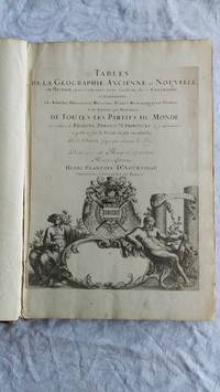
Tables de la Geographie Ancienne et Nouvelle ou Methode pour s'instruire Avec facilité de la Geographie, et Connoistre Les Empires, Monarchies, Royaumes, Estats, Republiques, et Peuples, tant Anciens que Nouveaux, de Toutes les Parties du Monde en combien de Regions Particulieres, ou Provinces, ils se subdivisent, et quelles en sont les Villes les plus considérables . Dediées a Monseigneur Monseigneur Pierre Seguier chevalier et Chancelier de France.
by Srs. Sanson [Nicolas et Guillaume Sanson]
- Used
- good
- Hardcover
- Condition
- Used - Good
- Binding
- Hardcover
- Quantity Available
- 1
- Seller
-
Lower Hutt, Auckland, New Zealand
- Item Price
-
A$4,260.85
Show Details
Description:
Paris Book. Good. Full-Leather. Elephant Folio - over 15 - 23" tall. 106 geographical tables. This copy has tables from various editions with printing dates from 1663 to 1741. The majority of tables date from 1663-1698. Most are in French but many also in Latin. The plates show different versions of the geographical tables. Please inquire for more details. The majority of tables are 20 inches, some tables are 16 inches and are pasted on blank pages. The leather binding is worn at the top and bottom of spine and on corners and edges..
Item Price
A$4,260.85

Amerique Septentrionale
by SANSON, Nicholas and Guillaume SANSON (d. 1703)
- Used
- Condition
- Used
- Quantity Available
- 1
- Seller
-
New York, New York, United States
- Item Price
-
A$4,338.32
Show Details
Description:
Paris: Chez Pierre Mariette, 1690. Copper-engraved map, period hand colouring in outline. Among the most important French maps of North America of the second half of the 17th century, produced by the country's most esteemed family of cartographers. This very influential map was the official successor to Nicolas Sanson's 1650 map of North America. When Nicolas Sanson, regarded as the father of the renaissance of cartography under Louis XIV, died in July, 1667, he left his flourishing business under the charge of his eldest son Guillaume. The younger Sanson continued his father's partnership with the Mariette family, who were prominent Parisian printers. Guillame was determined to publish a new, updated edition of his father's Cartes Generales de toutes parties du Monde, the first French general atlas, originally published in 1657. The map of North America that appeared in the atlas, although masterful, was now considered to be geographically outdated. The present map, which appeared in the second…
Read More Item Price
A$4,338.32

Amerique Septentrionale
by SANSON, Nicholas, and Guillaume SANSON (d. 1703)
- Used
- Condition
- Used
- Quantity Available
- 1
- Seller
-
New York, New York, United States
- Item Price
-
A$5,035.55
Show Details
Description:
Paris: Chez Pierre Mariette, 1669. Copper-engraved map, period hand colouring in outline. The most important French map of North America of its generation, produced by the country's most esteemed family of cartographers. This very influential map was the official successor to Nicolas Sanson's 1650 map of North America. When Nicolas Sanson, regarded as the father of the renaissance of cartography under Louis XIV, died in July, 1667, he left his flourishing business in the care of his eldest son Guillaume. The younger Sanson continued his father's partnership with the Mariette family, who were prominent Parisian printers. Guillame was determined to publish a new, updated edition of his father's Cartes Generales de toutes parties du Monde, the first French general atlas, originally published in 1657. The map of North America that appeared in the atlas, although masterful, was now considered to be geographically outdated. The present map, which appeared in the second edition of the atlas, featured…
Read More Item Price
A$5,035.55
