Description:
New York: Sanborn Map Company, 1909. List of Maps collated complete; all are hand colored; 11 double page maps, approximately 21" x 25" size opened; Locations include all of the town and surrounds of Riverhead, Long Island, listing businesses, fire houses, water facilities, public utilities, Suffolk County Agricultural Society Fair Grounds with Race Track, Peconic River and all the businesses at the riverside in this time: Tower Roller Mill, C. Hallet's Sons Flour Mill & Electric Light Plant, Auxiliary Plant, Carriage Repository, Lumber & Construction businesses, boat & carpenter shops, American Ice Company, Frank H. Hill & Bro. Monument Works, county buildings-court house complex & jail, Long Island House, Banks, Public Library, tailor, jewelry, drug, tobacco & cigarette retailers, horse boarding & livery stables, S. Terry Hudson Agricultural Implement Works, Riverhead Coal Co., Shinnecock Distributing Co., Beer Agents & Soda Water Bottlers, railroads-…
Read More Land Book of the Borough of Manhattan, City of New York. Desk and Library Edition. 1925. by N/A - 1925
by N/A

Land Book of the Borough of Manhattan, City of New York. Desk and Library Edition. 1925.
by N/A
- Used
New York: G. W. Bromley & Co., 1925. 1925 edition. VERY GOOD+. Pages are near fine; lightly toned along the outside margins but otherwise clean and unmarked, the colors clear and bright. Two leaves have short closed tears at bottom edge, but otherwise pages are exceptionally fine. Black cloth hardcover, red stamped title on front, is clean, moderately rubbed along edges and hinges. Cloth is frayed at spine ends, corners and several spots on the outside edges. Binding intact though loose, the hinges wobbly. All pages are firmly held. The book should stand gentle use for some time but would benefit from a professional binding reinforcement. An extraordinarily detailed record of Manhattan in a series of 191 maps clearly showing the streets and outlines of each and every structure, every park, every railroad track including elevated railroads, water and sewer pipes and even fire hydrants, from Battery Park to 228th Street. Even more miraculously, details about the buildings are supplied through ingenious keys. Clearly noted are the number of stories, the depth of the building, presence of basements, of storefronts, and elevators. Even structure (brick, frame or iron covered) is indicated by coloring. Each of the plates has been meticulously hand-tinted in pinks, blues, yellows - and greens if a park is present. To help the user navigate the maps a 1-page Block Index (printed on the front pasted endpaper), 4-page Street Index and 5-Page Map Index (which include the "Explanations" or keys) are provided at the front of the book. The 191 plates follow. Book measures 16-3/4 x 11-3/4". An unusually well-preserved copy of this scarce, very desirable work. Additional photos available on request.. Hardcover. Very Good+/Not Issued. Folio.
-
Bookseller
Independent bookstores
 (US)
(US)
- Format/Binding
- Book Condition Used - Very Good+
- Jacket Condition Not Issued
- Publisher G. W. Bromley & Co.
- Place of Publication New York
- Date Published 1925
- Size Folio

More Photos
Riverhead Suffolk County New York Atlas
by (Riverhead)
- Used
- Very Good
- Paperback
- Condition
- Used - Very Good
- Binding
- Paperback
- Quantity Available
- 1
- Seller
-
Bolivia, North Carolina, United States
- Item Price
-
A$2,756.70
Show Details
Item Price
A$2,756.70

More Photos
Britannia depicta or Ogilby improv'd; being a correct coppy of Mr. Ogilby's Actual survey of all ye direct & principal cross roads in England and Wales: . . . And to render this—work universally usefull & agreeable, . . . are added . . . 1. A full & particular description & account of all the cities, borough-towns, towns-corporate . . . By Ino. Owen . . . 2. The arms of the peers of this realm . . . 3. The arms of all ye bishopricks & deanaries, . . . 4. The arms, & a succinct account of both universities & their respective colleges, . . . Lastly particular & correct maps of all ye counties of South Britain; with a—summary description of each county, . . . By Eman: Bowen engraver
by OGILBY, John (1600-1676); BOWEN, Emanuel (1693/4-1767)
- Used
- Fine
- first
- Condition
- Used - Fine
- Edition
- First Edition
- Binding
- Unknown
- Quantity Available
- 1
- Seller
-
Lancaster, Pennsylvania, United States
- Item Price
-
A$4,439.82
Show Details
Description:
London: Printed for, & sold by Tho: Bowles print & map seller next ye. Chapter House in St. Pauls Church-Yard & Em. Bowen next ye King of Spain in S: Katherines, 1720. First Edition. Full Calf. Fine. First edition, first or second issue, of this fully and finely engraved road atlas of England and Wales, a smaller-format popular version of Ogilby's famous road atlas, originally published in two versions (both 1675), in folio editions. Small 4to (204 x 120mm): [6],273,[1]pp, comprising 54 county maps and associated suites of strip road maps in three or four columns over 273 plates engraved front and back by Emanuel Bowen. Contemporary Cambridge-style paneled calf, sympathetically rebacked, spine with five raised bands ruled in gilt, recent red morocco lettering piece gilt, all edges speckled red, plain period end papers. An all-together elaborate production, in Fine, clean, bright condition, each map fully and elaborately engraved by Emanuel Bowen and enhanced with little-known historical facts…
Read More Item Price
A$4,439.82
More Photos
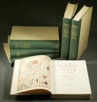
Mapping the Transmississippi West, 1540–1861,
by Wheat, Carl Irving (1892-1966)
- Used
- near fine
- Hardcover
- first
- Condition
- Used - Near Fine
- Edition
- First
- Binding
- Hardcover
- Quantity Available
- 1
- Seller
-
Fort Worth, Texas, United States
- Item Price
-
A$4,211.62
Show Details
Description:
From the Spanish discovery to the opening of the Civil War5 volumes in 6. Volume One: The Spanish Entrada to the Louisiana Purchase 1540-1804 xiv+264 pages with color frontispiece map and 275 maps (many folding) and index; Volume Two: From Lewis and Clark to Fremont 1804-1845 xiii+281 pages with colored frontispiece map, 143 additional maps (some folding) and index. Volume Three: From the Mexican War to the Boundary Surveys 1846-1854 xiii+349 pages with colored frontispiece map, 322 additional maps and index; Volume Four: From the Pacific Railroad Surveys to the Onset of the Civil War 1855-1860 xiii+260 pages with color frontispiece map, an additional 127 maps (some folding) and index; Volume Five From the Civil War to the Geological Survey, Part One: xviii+222 pages with color frontispiece map and an additional 152 maps; Volume Five From the Civil War to the Geological Survey, Part Two: [223]-487 pages with 124 maps and index. Folio (14 1/2" x 10 1/2") bound in quarter green leather with gilt…
Read More Item Price
A$4,211.62
More Photos
A System of Geography: or, A New & Accurate Description of the Earth in all its Empires, Kingdoms and States. Illustrated with History and Topography and Maps of every Country. Fairly engraven on copper, according to the latest discoveries and Corrections
by Moll, Herman and Rober Falconer
- Used
- first
- Condition
- Used
- Edition
- First Edition
- Binding
- Unknown
- Quantity Available
- 1
- Seller
-
Scottsdale, Arizona, United States
- Item Price
-
A$2,871.56
Show Details
Description:
London: For A. and J. Churchil and T. Childe, 1701. First Edition. Folio. From the library of John, Earl of Loudoun (John Campbell, Fourth Earl of Loudoun (5 May 1705 - 27 Apr. 1782) In 1727, Campbell entered the Army. He was commissioned major general in 1755, and appointed the following year as commander-in-chief of British forces in America during the French and Indian War, and named titular governor of Virginia. Variant issue, with both Churchil & Childe in imprint, 2 parts in 1 volume. Frontispiece, title page in red and black, 4; [24] contents, 444pp; 1-230; [28]pp. index. While the collation is haphazard, the book itself is complete with all catchwords matching, (with dupicate 125 pagination as in all copies) Frontispiece, 2 Engravings of Ptolomei and Copernici systems; 2 engraved compasses; and 44 textual maps, (45 maps if one counts the small china strip map).Contains the following maps. 1. Earth 2. Europe 3. Britain 4.Scotland 5. Ireland 6. France 7. Netherlands 8. United…
Read More Item Price
A$2,871.56

More Photos
Philips' Commercial Map of China
by HOSIE, SIR ALEXANDER. (EDITED BY).
- Used
- Hardcover
- Condition
- Used
- Binding
- Hardcover
- Quantity Available
- 1
- Seller
-
Canberra, Australian Capital Territory, Australia
- Item Price
-
A$2,500.00
Show Details
Description:
[London].: George Philip & Son.. No date. (circa1937).. Very large, handsome coloured linen backed map 167.5 x 114.5cm, folds into cloth boards 29.5 x 24.5cm. Scale 1:3,000,000 or 48 miles to an inch. Marbled front free endpaper creased and torn with some loss. Ribbon ties detached, cloth soiled, corners of corners worn and bumped, cloth along case joints torn in places. Although the case shows wear this striking map is in excellent condition. The map features three inset maps: Shanghai/Nanking District; Peking Tsinan District and Sinkiang. A key gives reference to the symbols of communities used which include animal and vegetable products, mineral products and manufactured products. A scarce map packed with fascinating detail of China at a crucial time in the country's history. .
Item Price
A$2,500.00

More Photos
富士見十三州輿地全圖. [Fujimi Jūsanshū yochi zenzu]. [Map of the Thirteen Provinces From Where Mt. Fuji Is Visible].
by AKIYAMA EINEN [OR NAGATOSHI] 秋山永年.
- Used
- Condition
- Used
- Edition
- [Reprint].
- Binding
- Unknown
- Quantity Available
- 1
- Seller
-
Canberra, Australian Capital Territory, Australia
- Item Price
-
A$2,500.00
Show Details
Description:
Shūseidō 衆星堂. [Reprint].. Tenpō 14 (1843).. Large folding handcoloured map of the thirteen provinces from which Mt. Fuji can be viewed. 159 x 178cm. Folds into paper covered card covers measuring 40 x 24cm. Title label upper cover. A little browning along folds, occasional spotting and soiling. A little worming causing approximately 1cm of loss in places. Two chops in lower section. A very striking and attractive map. This very large handsome map is a detailed map of the thirteen provinces from which one can see Mt. Fuji. Provinces shown are the eight provinces of the Kantō region, Sagami 相模, Musashi 武蔵, Kazusa 上総, Shimofusa 下総, Awa 安房, Kōzuke 上野, Shimotsuke 下野, and Hitachi, 常陸, and five other provinces, Izu 伊豆, Suruga 駿河, Tōtōmi 遠江, Kai 甲斐, and Shinano 信濃. The map…
Read More Item Price
A$2,500.00

More Photos
Catalogue des Cartes Géographiques, Topographiques & Marines, de la Bibliothèque du Prince Alexandre Labanoff de Rostoff, a Saint-Pétersbourg. Suivi d'une Notice de Manuscrits
- Used
- Very Good
- Hardcover
- first
- Condition
- Used - Very Good
- Edition
- 1st Edition
- Binding
- Hardcover
- Quantity Available
- 1
- Seller
-
Kraków, Poland
- Item Price
-
A$3,659.40
Show Details
Description:
Paris: Firmin Didot, 1823 8vo (20 x 13.2 cm), VIII, 494, [2] pp, half chagrin over marbled boards, with original wrappers bound in (slightly foxed, blind collector stamps on the title and the first page). This is the catalog of the map collection of Duke Aleksandr Lobanov-Rostovsky (1788-1866), a Russian general and diplomat. The catalog was authored by the Duke himself, with assistance from Charles Piquet. This edition is one of the 230 copies privately printed by Firmin Didot.
Item Price
A$3,659.40

More Photos
抗美援朝時事學習地圖. [Kang Mei yuan Chao shi shi xue xi di tu]. [Current Affairs Study Map - Resisting US Aggression and Aiding Korea].
by [YA XIN CARTOGRAPHIC STUDY SOCIETY].[亞新地學社].
- Used
- first
- Condition
- Used
- Edition
- 1st Edition.
- Binding
- Unknown
- Quantity Available
- 1
- Seller
-
Canberra, Australian Capital Territory, Australia
- Item Price
-
A$2,750.00
Show Details
Description:
武昌.[Wuchang].: 亞新地學社.[Ya xin di xue she].. 1st Edition.. August1951.. Large detailed colour Chinese map of Korean War, folded, scale 1:15,000,000, three inset maps on corners, illustrated legend showing agricultural and mining resources lower margin, in original envelope. Some light wear along edges, small holes and wear at folds mended with archival tape, envelope torn with loss mended with archival tape. Inset map 兩個陣營力量對比 "Strength Comparison Between The Two Camps" upper left corner, scale 1: 170,000,000. The Peaceful Camp in red covering the majority of Asia and Europe, a list of 6 countries (Germany, Czech, Hungary, Romania, Bulgaria, Albania) are numbered and are also part of the Peaceful Camp. The Invader Camp in grey covering North America and small parts of Europe, a list of 3 nations (Netherlands, Belgium, Luxembourg) are numbered and are also part of the Invader Camp. Block of text in…
Read More Item Price
A$2,750.00

More Photos
L’Utrecht suivant les nouvelles observations de Messrs. de l’Academie des Sciences etc. Augmentées de nouveau.
by Covens, Johannes et Cornelis Mortier
- Used
- Condition
- Used
- Quantity Available
- 1
- Seller
-
Tuebingen, Germany
- Item Price
-
A$3,735.45
Show Details
Description:
Engraved and partially hand-coloured map with nice figurative cartouche mounted on wood, backside lined with blue paste paper with impressed decoration (= complete). Oblong folio (300 x 223 mm). All pieces loosely contained in contemporary wooden box with a sliding lid with manuscript title "Utrecht" on top. A very early example of this kind of game, and hard to find complete and in very good overall condition.
Item Price
A$3,735.45
More Photos
A complete genealogical, historical, chronological and geographical atlas: Lavoisne Atlas
by C V Lavoisne
- Used
- Very Good
- Hardcover
- Condition
- Used - Very Good
- Jacket Condition
- none
- Edition
- 2nd
- Binding
- Hardcover
- Quantity Available
- 1
- Seller
-
Dixon, Illinois, United States
- Item Price
-
A$3,828.75
Show Details
Description:
C V Lavoisne; C Gros; Jehoshaphat Aspin; E PaguenaudA complete genealogical, historical, chronological and geographical atlas; being a general guide to history, both ancient and modern: exhibiting an accurate account of the origin, descent, and marriages of all the royal families . the whole forming a complete system of history and geographyPhiladelphia, Published by M. Carey and Son; printed by T.H. Palmer, 1820-01-01. 2nd American ed., carefully rev. Hardcover. Good. Second American edition, published in the same year as the first American edition. Folio, 46 x 34 cm, (17 1/2 x 11 7/8 inches). Bound with contemporary gilt letter spine over boards. Good condition for being an 1820's copy. Beautiful marbled paper over boards both outside and inside covers. Original spine still holding except for a split at the bottom and a small chunk missing. See Pic. Sought after John Melish United States map in the back. Some paper loss on the title page with some small holes. Maps are in very good condition with a…
Read More Item Price
A$3,828.75

Stock Photo: Cover May Be Different
Peppa's First Glasses
by NA
- Used
- Paperback
- Condition
- Used: Good
- Binding
- Paperback
- ISBN 10 / ISBN 13
- 9780718197841 / 0718197844
- Quantity Available
- 1
- Seller
-
HOUSTON, Texas, United States
- Item Price
-
A$5.53
Show Details
Description:
Ladybird, 2014-01-01. Paperback. Used: Good.
Item Price
A$5.53

Stock Photo: Cover May Be Different
A Book of Sleep
by Na, Il Sung
- Used
- Condition
- Used - Good
- ISBN 10 / ISBN 13
- 9780375866180 / 0375866183
- Quantity Available
- 1
- Seller
-
Waltham, Massachusetts, United States
- Item Price
-
A$1.53
Show Details
Description:
Knopf Books for Young Readers. Used - Good. . . All orders guaranteed and ship within 24 hours. Your purchase supports More Than Words, a nonprofit job training program for youth, empowering youth to take charge of their lives by taking charge of a business.
Item Price
A$1.53

The Gazer Pocket Guidebook to Mexico
by n.a
- Used
- Paperback
- Condition
- Used - fair; soil to rear wrap; several repaired tears to front wrap. All else-tight.
- Binding
- Paperback
- Quantity Available
- 1
- Seller
-
Golconda, Illinois, United States
- Item Price
-
A$12.25A$6.13Save A$4.00!
Show Details
Description:
Mexico : Editorial Monex, 1957. Paperback. fair; soil to rear wrap; several repaired tears to front wrap. All else-tight.. small paperback, glued spine; 112 pp; includes tips for travelers, advertisements for hotels, restaurants and points of interest. Also flights from U.S. to Mexico.
Item Price
A$12.25A$6.13
Save A$4.00
!

Stock Photo: Cover May Be Different
Snow Rabbit, Spring Rabbit: A Book of Changing Seasons
by Na, Il Sung
- Used
- Condition
- Used - Good
- ISBN 10 / ISBN 13
- 9780307977908 / 0307977900
- Quantity Available
- 1
- Seller
-
Waltham, Massachusetts, United States
- Item Price
-
A$1.53
Show Details
Description:
Knopf Books for Young Readers. Used - Good. . . All orders guaranteed and ship within 24 hours. Your purchase supports More Than Words, a nonprofit job training program for youth, empowering youth to take charge of their lives by taking charge of a business.
Item Price
A$1.53

Stock Photo: Cover May Be Different
A Step From Heaven
by Na, An
- Used
- Condition
- Used - Good
- ISBN 10 / ISBN 13
- 9780142500279 / 0142500275
- Quantity Available
- 1
- Seller
-
Waltham, Massachusetts, United States
- Item Price
-
A$1.53
Show Details
Description:
Speak. Used - Good. . . All orders guaranteed and ship within 24 hours. Your purchase supports More Than Words, a nonprofit job training program for youth, empowering youth to take charge of their lives by taking charge of a business.
Item Price
A$1.53
Stock Photo: Cover May Be Different
A Step From Heaven
by Na, An
- Used
- Condition
- Used - Very Good
- ISBN 10 / ISBN 13
- 9780142500279 / 0142500275
- Quantity Available
- 1
- Seller
-
Waltham, Massachusetts, United States
- Item Price
-
A$1.79
Show Details
Description:
Speak. Used - Very Good. . . All orders guaranteed and ship within 24 hours. Your purchase supports More Than Words, a nonprofit job training program for youth, empowering youth to take charge of their lives by taking charge of a business.
Item Price
A$1.79
Stock Photo: Cover May Be Different
A Book of Sleep
by Na, Il Sung
- Used
- Condition
- Used - Very Good
- ISBN 10 / ISBN 13
- 9780375866180 / 0375866183
- Quantity Available
- 1
- Seller
-
Waltham, Massachusetts, United States
- Item Price
-
A$1.79
Show Details
Description:
Knopf Books for Young Readers. Used - Very Good. All orders guaranteed and ship within 24 hours. Your purchase supports More Than Words, a nonprofit job training program for youth, empowering youth to take charge of their lives by taking charge of a business.
Item Price
A$1.79

Stock Photo: Cover May Be Different
Little White Duck: A Childhood in China
by Liu, Na
- Used
- Condition
- UsedGood
- ISBN 10 / ISBN 13
- 9780761381150 / 0761381155
- Quantity Available
- 1
- Seller
-
Imperial, Missouri, United States
- Item Price
-
A$6.75
Show Details
Description:
UsedGood.
Item Price
A$6.75

Stock Photo: Cover May Be Different
A STEP FROM HEAVEN
by Na, An
- Used
- Condition
- UsedGood
- ISBN 10 / ISBN 13
- 9781481442367 / 1481442368
- Quantity Available
- 1
- Seller
-
Imperial, Missouri, United States
- Item Price
-
A$6.75
Show Details
Description:
UsedGood. The item shows wear from consistent use, but it remains in good condition and works perfectly. All pages and cover are intact (including the dust cover, if applicable). Spine may show signs of wear. Pages may include limited notes and highlighting. May NOT include discs, access code or other supplemental materials.
Item Price
A$6.75
WIR: Wir. Grundkurs Deutsch f�r junge Lerner 2. Lehrbuch. Alle Bundesl�nder. (Lernmaterialien)
by NA
- Used
- Good
- Paperback
- Condition
- Used - Good
- Binding
- Paperback
- ISBN 10 / ISBN 13
- 9783126757607 / 312675760x
- Quantity Available
- 1
- Seller
-
Chicago, Illinois, United States
- Item Price
-
A$2.28
Show Details
Description:
Paperback. Good. 0.3100 in x 10.2400 in x 7.5600 in.
Item Price
A$2.28

More Photos
The Sky and the Forest
by Forester, C.S
- Used
- Very Good
- Hardcover
- first
- Condition
- Used - Very Good
- Jacket Condition
- Very Good
- Edition
- First Edition
- Binding
- Hardcover
- Quantity Available
- 1
- Seller
-
Salem, Oregon, United States
- Item Price
-
A$53.43A$26.72Save A$17.44!
Show Details
Description:
C.S. Forester: The Sky and the Forest. Little, Brown and Company, Boston. Stated First Edition First Printing Thus August, 1948. Cover price $2.75. Used. VG BOOK/VG UNCLIPPED DUST JACKET. A story of a central Africa. By C.S. Forester, author of the Admiral Hornblower series.
Item Price
A$53.43A$26.72
Save A$17.44
!

More Photos
Plat Book: Pierce County, Wisconsin
by Rhame, A. E
- Used
- Fine
- Paperback
- Condition
- Used - Fine
- Binding
- Paperback
- Quantity Available
- 1
- Seller
-
Woodruff, Wisconsin, United States
- Item Price
-
A$71.46
Show Details
Description:
1930. Soft Cover. Fine. Unpaginated. Tan colored book is in Fine condition, no sign of wear.
Item Price
A$71.46
![Alaska and Klondike Region; [With inset of Klondike Region on the Upper Yukon detail] [From an...](https://d3525k1ryd2155.cloudfront.net/h/062/537/1339537062.0.m.jpg)
Alaska and Klondike Region; [With inset of Klondike Region on the Upper Yukon detail] [From an atlas, "Gazetteer of Alaska and Yukon Region " pp. 105 and 106]
by Miller, J. Martin
- Used
- Very Good
- Condition
- Used - Very Good
- Edition
- Unknown
- Quantity Available
- 1
- Seller
-
Sebastopol, California, United States
- Item Price
-
A$59.73
Show Details
Description:
Chicago: J. Martin Miller, 1899. Unknown. Map. Very Good. [Map copyright 1899, printing date of Atlas later] [19.875x15.125in]; Colored map of Alaska with steamer routes from Portland and Seattle, insets of the Klondike Region on the Upper Yukon and Western portion of Aleutian Islands; On verso index of places and names with two large black and white images; Age toning to all edges, water stain marks on bottom, slight printing offset of colors, small chips and closed tears to lower edge;.
Item Price
A$59.73

Last Tales
by Dinesen, Isak
- Used
- Very Good
- Hardcover
- first
- Condition
- Used - Very Good
- Jacket Condition
- Good+
- Edition
- First Edition
- Binding
- Hardcover
- Quantity Available
- 1
- Seller
-
Salem, Oregon, United States
- Item Price
-
A$183.78A$91.89Save A$60.00!
Show Details
Description:
Dinesen, Isak: Last Tales, A Collection of Twelve New Tales of Compelling Beauty 1957, Random House. First Edition. Stated First Printing Thus. Used. Very Good/Good+ original red dust jacket, price-clipped. Jacket states 11/57 on front flap. 5 3/4 X
Item Price
A$183.78A$91.89
Save A$60.00
!

Zemepis Sveta - Monsunova Asie
by De La Blache, P. Vidal; Gallois, L
- Used
- Hardcover
- Condition
- Used - Very Good Condition
- Jacket Condition
- No Dust Jacket
- Binding
- Hardcover
- Quantity Available
- 1
- Seller
-
Oak Point, Texas, United States
- Item Price
-
A$91.89
Show Details
Description:
Aventinum, Prague, Czechoslovakia, 1931. Hardcover. Very Good Condition/No Dust Jacket. Text entirely in Czech. Geography book on Asia with numerous photographs and maps. 1930 edition also available. Size: 4mo - over 9 3/4" - 12" tall. 400 pp. Pages are yellowed, but are tight and clean. Moderate shelfwear along the spine. Corners are lightly bumped. Quantity Available: 1. Shipped Weight: 3-5 pounds. Category: Travel & Places; Non-English Language::Czech; Pictures of this item not already displayed here available upon request. Inventory No: 001228. . Additional shipping charges may apply.
Item Price
A$91.89

Zemepis Sveta - Monsunova Asie
by De La Blache, P. Vidal; Gallois, L
- Used
- Hardcover
- Condition
- Used - Very Good Condition
- Jacket Condition
- No Dust Jacket
- Binding
- Hardcover
- Quantity Available
- 1
- Seller
-
Oak Point, Texas, United States
- Item Price
-
A$91.89
Show Details
Description:
Aventinum, Prague, Czechoslovakia, 1930. Hardcover. Very Good Condition/No Dust Jacket. Text entirely in Czech. Geography book on Asia with numerous photographs and maps. 1931 edition also available. Size: 4mo - over 9 3/4" - 12" tall. 400 pp. Pages are yellowed, but are tight and clean. Moderate shelfwear along the spine. Corners are lightly bumped. Quantity Available: 1. Shipped Weight: 3-5 pounds. Category: Travel & Places; Non-English Language::Czech; Pictures of this item not already displayed here available upon request. Inventory No: 001227. . Additional shipping charges may apply.
Item Price
A$91.89

The Adventure of Wrangel Island
by Vilhjalmur Stefansson
- Used
- Good
- Hardcover
- first
- Condition
- Used - Good
- Jacket Condition
- No DJ Included
- Edition
- First Edition
- Binding
- Hardcover
- Quantity Available
- 1
- Seller
-
Salem, Oregon, United States
- Item Price
-
A$191.27A$95.64Save A$62.44!
Show Details
Description:
The Adventure of Wrangel Island, Alaska (1925 Macmillan 1st Edition) HISTORY OF ALASKA. EXLIB. Good Condition/ No DJ included. Fold-out map affixed to binding at the back of the book has never been opened. The story of the (unsuccessful) attempted colonization of Wrangel Island Alaska. 413 pages plus appendix, Index. Titling is still bright. A clean, solid copy. Scarce.
Item Price
A$191.27A$95.64
Save A$62.44
!

Seven Pillars Of Wisdom, A Triumph
by Lawrence, T.E
- Used
- Good
- Hardcover
- first
- Condition
- Used - Good
- Jacket Condition
- No DJ Included
- Edition
- First American Edition
- Binding
- Hardcover
- Quantity Available
- 1
- Seller
-
Salem, Oregon, United States
- Item Price
-
A$191.36A$95.69Save A$62.47!
Show Details
Description:
T.E. Lawrence. SEVEN PILLARS OF WISDOM, A TRIUMPH. AUTOBIOGRAPHY. Privately Printed, 1926. First Published for general circulation 1935. First American Edition. States MCMXXXVI on the title page. Doubleday, Doran & Company, Inc. Garden City, NY. GOOD CONDITION/ NO DUST JACKET IS INCLUDED. 672 pages, indexed. Beige buckram boards. Spine has darkened a bit. 6 7/8 X 9 ½.
Item Price
A$191.36A$95.69
Save A$62.47
!

North America from the Best Authorities, Russell, ca.1800
by Russell
- Used
- Condition
- Used
- Quantity Available
- 1
- Seller
-
Plymouth, Devon, United Kingdom
- Item Price
-
A$38.95
Show Details
Description:
Russell, J. : A General Map of North America from the Best Authorities. Nd but ca.1800. From "A New Geographical, Historical and Commercial Grammar and Present State of Several Kingdoms of the World." Copper engraving. Size approx 200 x 230mm. Two neat folds. Some age colouring to edges, otherwise very clean and bright.
Item Price
A$38.95

Asia from the Best Authorities, Russell, ca.1800
by Russell
- Used
- Condition
- Used
- Quantity Available
- 1
- Seller
-
Plymouth, Devon, United Kingdom
- Item Price
-
A$38.95
Show Details
Description:
Russell, J. : Asia from the Best Authorities. Nd but ca.1800. From "A New Geographical, Historical and Commercial Grammar and Present State of Several Kingdoms of the World". Copper engraving. Size approx 200 x 230mm. Two neat folds. Some age colouring to edges, otherwise clean and bright. Includes Arabia, India, Borneo, Japan, China and eastern Russia.
Item Price
A$38.95