Click for full-size.


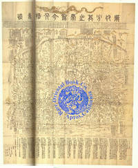
LI DAI SHAOLIN SHI GIA JEN WU SHI GI. HISTORICAL CHINA MAP. A MAGNIFICENT & LARG
by SHAOLIN SI. [SHAO-LIN MONASTERY/TEMPLE, CHINA.]
- Used
- Hardcover
Payment Methods Accepted
About This Item
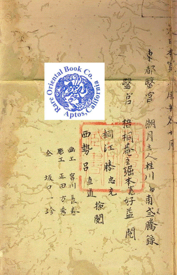
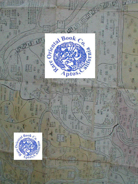
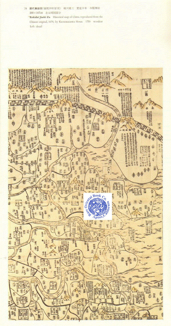
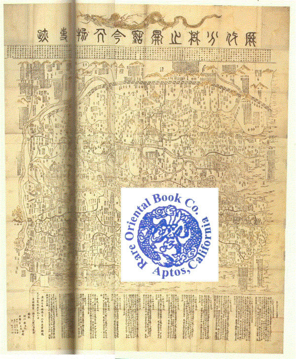
Edo 1750, Suharaya Mohei. Large folding map, 170 x 200 cm. old mended worming, rebacked,pastel colors, Japanese reprint of a map printed in Henan in 1679, folds down to be 21.5 x 25.5 cm., woodblock printed, hand color. V E R Y R A R E ! *** *** *** . . AN EXCEPTIONALLY RARE WALL-SIZE MAP OF CHINA . . EXECTED BY A SHAOLIN ZEN MASTER *** The Shaolin Xi [Monastery/Temple] is a Chán [Zen] Buddhist temple at Song Shan near Zheng Zhou City, Henan Province in Dengfeng, China. It was led by Venerable abbot Shi Yongxìn. founded in the 5th century, the monastery has been famous for centuries its association with Chinese martial arts and particularly with Shaolin Kung Fu. It is also a Mahayana Buddhist monastery perhaps best known to the Western world. . The Shaolin Monastery and its famed Pagoda Forest were inscribed as a UNESCO World Heritage Site in 2010 as part of the Historic Monuments of Dengfeng. Extracted from Wikipedia. . *** A RARE EDITION: Reprinted and published in Japan by Katsuragawa Hosan in 1750, reproduced from the Chinese original of Kangxi 27 [1679]. The original Chinese edition has been exceptionally obscure and impossible to come by for over the last two-hundred years and is believed now to be lost to posterity. . *** PRINTING TECHNIQUE AND THE PAPER: The work is woodblock printed by hand on hand-made Washi paper, then hand-colored in delicate pastels. . *** CHINESE VIEW OF ANCIENT CHINA: This grand scale work covers a very large space and is quite handsome, suitable for framing and display. The map shows a full view of all of China, from the Great Wall in the North, Shanghai, the East coast, down to the oceans in the South and Hainan Island, and the coasts along he Eastern shores. This is a spectacular work, showing each province in pastel colors, with outlines, large numbers of place names, rivers & the major waterways, mountains named and located. By and large inspired to show all of the known lands considered a part of China, delineating the country and its exterior boundaries. . Japan and other islands are not shown, but boxes with notes in Chinese as to their existence and location are well documented. The lower portion has text discussing the population of the various provinces and other notes. Areas beyond the traditional lines of China, i.e.: North of the Great Wall, and to . *** RARITY OF THE MAP AND ITS MAKERS: This grand-scale and truly spectacular work is virtually never found on the market. The Shaolin Monastery monks were the original founders of the celebrated and now famous Kung-fu martial art school, located in Henan province. The priests were legendary and the most feared for their martial art prowess. They were also covert with their powerful political force in China. . *** SHAOLIN SI [TEMPLE/MONASTERY] LEGENDARY CUSTOMS: Priests who passed the highest level of Kung-fu martial art were invited to participate in a recognition ceremony. They were allowed to self-brand themselves by picking up a red-hot iron brazier that had long temple dragon decorations on the sides. The branding was accomplished by clamping the brazier between their forearms until the dragon image was branded on them. These brazier dragons are identical to the long dragon found at the top of this historic map. * Another ancient practices used was the Jieba. It is an ancient ceremony where nine marks are burned onto the head with sticks of incense. In 2007 the Chinese government partially lifted the 300-year ban of the Jieba, allowing the the mentally and physically prepared to participate in the ancient tradition. Incense or moxa was used on top of the shaved head and burned in a ceremony of dedication to the Shaolin Si [temple/monastery] by the most skilled of martial artists. * WHY THE DRAGON SYMBOL WAS USED BY SHAOLIN MONKS: The top of the map show the dragon as a symbol of the Shaolin Si. In China the dragon is the first of twelve zodiac animals and is the most powerful of all and represents the ultimate and greatest of all powers known. It is also the one and only legendary animal in the zodiac, the rest are actual animals. Because this map was conceived of, carved and printed at the Shaolin Xi monastery [or temple] by these very priests, they put the most powerful symbol at the top, a dragon. The symbolic meaning indicated that China was superior to all other nations. It was also a private pun by the Shaolin priests indicating for all to see and know that the Shaolin temple and its priests were above all others. Additionally it reminded and indicated that the Shaolin priest were the most powerful martial artists and covert political force in all China. . *** RARITY: The original Chinese edition has been exceptionally obscure and impossible to come by for over the last two-hundred years and is believed now to be lost to posterity. * Shaolin Si [temple/monastery] imprints are very R A R E ! Few references or examples exist of their woodblock printed works. This edition was a copy of the original re-carved by the Japanese and reissued. Not only is this map of great interest to Chan [Zen] Buddhists, Shaolin Kung-fu collectors, martial artists and historians, but to students of Chinese cartography, collectors and museums. . *** CONDITION: The map has been professionally re-backed in its distant past, due to the large amount of old worming. It is now solid and stable. Because of the rarity of this work, a complete map found in any condition would be now considered exceptionally R A R E ! Please review images posted to our website to observe the restored condition. . *** THE COVERS: The map has been rebound in non-original paper covers, perhaps about 100 years ago. It is contained in a brown cloth Chuan [Chitsu] folding slipcase, with ivory clasps, cloth a bit faded, one edge a bit worn, else clean & solid. . *** THE SCANS: While we have made efforts to take good digital photographs and scans of our copy, due to the exceptionally large size of the map, these photos are not of the highest quality. We therefore are additionally using copies of this map from the Oda reference book illustrations as samples of what the map is like. Please note the following digital images are from Oda: cover.jpg, illus08.jpg & illus12.jpg, the balance are from our digital camera. . Any client who purchases this map may be interested in the Japanese text found in Oda. Upon request, we are happy to provide a copy of his entry. . *** BIBLIOGRAPHY: G. Beans: A LIST OF JAPANESE MAPS OF THE TOKUGAWA ERA, Supplement A, on p.14, as #1750.1, with confirmation date of 1750. Beans gives this the title: "THE BEST COLLECTION OF ANCIENT AND MODERN WORKS CONCERNING THE HISTORICAL EVENTS THROUGHOUT THE DYNASTIES, BY THE MONASTERY OF SHAO-LIN." * T. Oda: THE WORLD IN JAPANESE MAPS UNTIL THE MID-19TH CENTURY, p.52-53, item #24 for 2 excellent color examples. Oda shows the Japanese title: REKIDAI JISEKI ZU: HISTORICAL MAP OF CHINA, reproduced from the Chinese original of 1679 by Katsuragawa Hosan, 1750. Beautifully reproduced here in full color. * Meir Shahar: The Xiaolin Monastery: History, Religion, and the Chinese Martial Arts. * Wikipedia: http://en.wikipedia.org/wiki/Shaolin_Monastery *** Color scans of this and most items are posted to our web site. .
Reviews
(Log in or Create an Account first!)
Details
- Bookseller
- Rare Oriental Book Company, ABAA, ILAB - AN ART AND INTELLECTUAL PROPERTY COMPANY
 (US)
(US)
- Bookseller's Inventory #
- 92110001
- Title
- LI DAI SHAOLIN SHI GIA JEN WU SHI GI. HISTORICAL CHINA MAP. A MAGNIFICENT & LARG
- Author
- SHAOLIN SI. [SHAO-LIN MONASTERY/TEMPLE, CHINA.]
- Book Condition
- Used -
- Binding
- Hardcover
- Keywords
- China: Social Science, Eclectic, All Subjects & Disciplines [no Art]; Maps Of China: Asian/chinese/european Printed Maps & Cartography; China: Cartographic References On Atlas, Maps And Related; Buddhism: All Native Asian Religions & Beliefs;
- Bookseller catalogs
- abaa-50;
Terms of Sale
Rare Oriental Book Company, ABAA, ILAB - AN ART AND INTELLECTUAL PROPERTY COMPANY
Payment due upon advice of total for the book including shipping & packing charges. Shipping charges may vary from what Biblio posts vs. what the actual costs are based on the weight & size of any book, its destination and value. We reserve the right to reassess "proper and appropriate" postage on any item regardless of what Biblio suggests as the rate of postage.To the above we will also charge for packing, insurance/registry/fedex as necessary depending on destination and value at our choice. Items over $500 at our choice, will possibly be sent by Federal Express, and billed to the buyer prior to acceptance of any order. If you are unsure please inquire prior to ordering or if you disagree with the above terms please DO NOT ORDER. All sales final, returns for any item not as described is part of the Biblio requirements. Unauthorized returns will not be accepted. All books are properly collated, described prior to listing. If you have any questions please inquire BEFORE ordering. All books are professionally packed, and protected from transit damage. Please view photos posted to our website or inquire with us for more information prior to ordering. Books are not sent on approval.
About the Seller
Rare Oriental Book Company, ABAA, ILAB - AN ART AND INTELLECTUAL PROPERTY COMPANY
Biblio member since 2006
APTOS, California
About Rare Oriental Book Company, ABAA, ILAB - AN ART AND INTELLECTUAL PROPERTY COMPANY
An Art & Intellectual Property Co. Since 1967* * * * *SINCE 1967, THE PAST FIFTY-YEARS WE HAVE BEEN PURVEYORS OF FINE & RARE BOOKS ON ALL ASPECTS FAR EASTERN, ASIAN & SOUTHEAST ASIAN CULTURES, COUNTRIES & SUBJECTS.Specialties include but are not limited to: CHINA, KOREA, JAPAN, TAIWAN, SINGAPORE, VIETNAM, INDO-CHINE, CAMBODIA, LAOS, PHILIPPINES, SHANGHAI, HONG KONG, CANTON, MACAO AREAS. LAFCADIO HEARN: First Editions, Manuscripts, Collections, Obscure Items, Japanese Cirimen-bon [Crepe Paper Books], LIBRARIES PURCHASED, APPRASIAL FOR ANY REASON. MEMBERS OF THE ABAA & ILAB SINCE JUNE 1973
Glossary
Some terminology that may be used in this description includes:
- Re-backed
- Describes a book that has had the material covering the spine replaced or joints mended.
- Inscribed
- When a book is described as being inscribed, it indicates that a short note written by the author or a previous owner has been...
- Cloth
- "Cloth-bound" generally refers to a hardcover book with cloth covering the outside of the book covers. The cloth is stretched...
- Rebound
- A book in which the pages have been bound into a covering replacing the original covering issued by the publisher.
- G
- Good describes the average used and worn book that has all pages or leaves present. Any defects must be noted. (as defined by AB...
- Rebacked
- having had the material covering the spine replaced. ...
- Reprint
- Any printing of a book which follows the original edition. By definition, a reprint is not a first edition.

Collecting and Using City Directories
Don’t overlook that old city directory - it is priceless for authors, collectors who focus on specific cities, geneaology, and other niche interests. Learn more...

A Brief History of the Dust Jacket
When did dust jackets first appear, and what exactly are they for? Learn about this often-important detail as it applies to book collecting. More...