
Click for full-size.
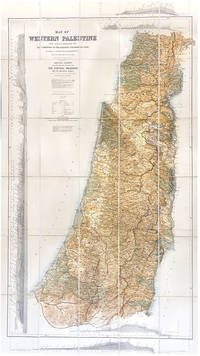
Map of Western Palestine from surveys conducted for the Committee Of Palestine Exploration Fund by Lieuts. C.R. Conder and H.H. Kitchener, R.E. . . . Special Edition Illustrating the Divisions of the Natural Drainage and the Mountain Ranges According to . . . Trelawney Sanders . . . 1882
by KITCHENER, Horatio, and Claude R. CONDER
- Used
- Hardcover
- Condition
- See description
- Seller
-
London, London, United Kingdom
Payment Methods Accepted
About This Item
London, Edward Stanford, 1881. Large colour-lithographic folding map (158 by 94cm) dissected into 30 segments, linen-backed and folding back into the original cloth-covered slip-case with printed label on the front; apart from light rubbing to front cover, in excellent condition. A wonderful copy of this Special Edition of the 'reduced' version of Conder & Kitchener's huge Map of Western Palestine, which consists of 26 sheets and is ordinarily found bound in atlas format. The present example of the map is heavily revised to illustrate the drainage of the Mountain Ranges in the eastern part of the map, "according to 'An Introduction to the Survey of Western Palestine' by Trelawney Sanders." Sanders did several adaptations of this map, one of which included ancient geographical information. This version of the map is particularly poignant because of the linkage between water resources, food production and settlement location. Field Marshal Horatio Herbert Kitchener, 1st Earl Kitchener, was an Irish-born British Field Marshal and proconsul who won fame for his imperial campaigns and later played a central role in the early part of the First World War, although he died halfway through it. In 1874, at age 24, Kitchener was assigned by the Palestine Exploration Fund, to a mapping-survey of the Holy Land, replacing Charles Tyrwhitt-Drake, who had died of malaria. Kitchener, then an officer in the Royal Engineers, joined fellow Royal Engineer Claude R. Conder and between 1874 and 1877 they surveyed what is today Israel, the West Bank, and Gaza, returning to England only briefly in 1875, after an attack by locals in the Galilee, at Safed.
Reviews
(Log in or Create an Account first!)
Details
- Bookseller
- Henry Sotheran Ltd.
 (GB)
(GB)
- Bookseller's Inventory #
- 2118192
- Title
- Map of Western Palestine from surveys conducted for the Committee Of Palestine Exploration Fund by Lieuts. C.R. Conder and H.H. Kitchener, R.E. . . . Special Edition Illustrating the Divisions of the Natural Drainage and the Mountain Ranges According to . . . Trelawney Sanders . . . 1882
- Author
- KITCHENER, Horatio, and Claude R. CONDER
- Book Condition
- Used
- Binding
- Hardcover
Terms of Sale
Henry Sotheran Ltd.
30 day return guarantee, with full refund including original shipping costs for up to 30 days after delivery if an item arrives misdescribed or damaged.
About the Seller
Henry Sotheran Ltd.
Biblio member since 2018
London, London
About Henry Sotheran Ltd.
Founded in York in 1761 and established in London on 1815, Henry Sotheran Limited has a long and distinguished history.For over 250 years we have been offering unsurpassed opportunities to collectors. Throughout our history we have prided ourselves on the quality and condition of our books and our friendly service.Our premises just off Piccadilly in the heart of London's West End are spacious and elegantly appointed and we welcome regular clients and passers-by alike to wander in and browse in a relaxing and convivial atmosphere.
Glossary
Some terminology that may be used in this description includes:
- Rubbing
- Abrasion or wear to the surface. Usually used in reference to a book's boards or dust-jacket.

Collecting Vintage Valentine’s Day Cards
Exchanging Valentines can be an awkward process, especially when you consider “Vinegar Valentines” and other snarky sentiments - whatever your tastes, enjoy the sweet and sour cards alike in this gallery!

Signed vs. Inscribed
Know what you are getting into when purchasing rare books, and learn the difference between signed books and inscribed books.
