Click for full-size.
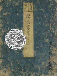
NANSEN BUSHU BANKOKU SHOKA NO ZU: BUDDHIST MAP OF THE UNIVERSE According to Zuda
by HOTAN, Priest. [ZUDA ROKASHI]
- Used
- Signed
Payment Methods Accepted
About This Item
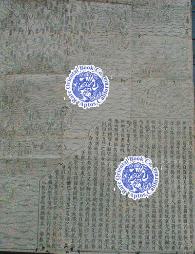
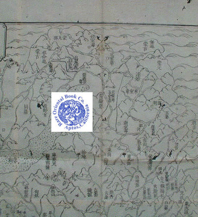
[Kyoto 1710, Nagata Chohbei]. Blue original paper covers, title slip, covers rubbed: some blue loss, woodblock printed 1 m. 44.5 x 1 m. 20 cm. accordion folded, very good impres- sion, excellent registry, white hand-made paper,clean solid. . *** *** *** . . . AN EARLY BUDDHIST MAP OF THE WORLD . . . ONE OF THE MOST FAMOUS EARLY MAPS . . . A GRAND & DELUXE WALL MAP . *** An excellent fine early example of a woodblock printed map, with Chinese text. This is the first Japanese world map drawn according to Buddhist cosmology & the prototype for all other later Buddhist world maps done in Japan until the end of the 19th century. . *** THE ARTIST AND AUTHOR: Hotan [aka Zuda Rokashi 1654-1728], was the author, artist, editor, scholar and Buddhist priest, he was also the famous founder of Kegonji Buddhist Temple in Kyoto. He was an eminent Buddhist priest and scholar who reconciled new information from the West with Chinese sources. The work is signed "Rokashi," which means "mapmaker and editor." . *** This map gave the hitherto isolated Japanese "a way to see a wider view of the world, but one that they could easily understand...his map was widely acclaimed for the numerous place names he furnished for Indian & Asian areas.. very rare in Western maps..." Quoted from Namba, see below. . *** The map is centered on Jambudvipa the mythological heart of Buddhist cosmography in India. This very vital spot is noted by a horned animal who's breath is a long spiral of flame emanating from the most sacred & holy Buddhist place on the earth. Europe appears as a string of islands. A land bridge connects China with an unnamed continent to its East, which "must undoubtedly be a reflection of America" in the opinion of the celebrated Japanese scholars. . *** Per Rudolph [see below], on p.92, she states: "This map is descended from a line of Japanese manuscript maps based on the journey of the Chinese priest Xuangzang's pilgrimage to India in search of scriptures. Scholars believe that the maps were originally copied out as a from of devotion--a pilgrimage of the spirit if not the body--and that later versions like this, which includes South America, demonstrate an attempt to reconcile sacred geography with the examples of European cartography that were reaching Japan through Dutch traders and, via China, Jesuit missionaries." . *** WHAT ONE MODERN CARTOGRAPHIC SCHOLAR SAYS: Cartographic scholars Prof. Oda discuss the Northern most Japanese island of Ezo where the Ainu lived is located on this map just slightly South of the mystery continent which is actually American. Africa is a diminutive land mass. To the far West is a small island empire identified as "Country of Western Women" along with other mountainous island kingdoms, likely England, Scotland and Ireland. The map text includes a list of Buddhist Sutras, Chinese histories, literary classics &c. All drawn by Hotan, which "Illustrates the fusion of Buddhist dogma and Western geographical knowledge." See Oda below. . *** PROTYPE MAP: The basic outlines of the map are copied from a Buddhist prototype, the Gotenjiku Zu [MAP OF THE FIVE INDIES], whose characteristic features was the shield-shaped continent of Jambu-dvipa. Jambu-dvipa was the habitable world according to the Buddhist cosmographical view. In this example the sacred lake of Anavatapta can be seen in the centre, from which flow four rivers in a whirlpool pattern. Jambu-dvipa can be equated topographically with the Indian peninsula, Lake Anavatapta symbolizes Lake Manasarovar in the Himalayas and the four rivers represent the Ganges, Oxus, Indus and Tarim. In order to preserve the traditional Buddhist outlines and at the same time incorporate the new knowledge of Western geography, the European and American countries are shown as small islands on the periphery of Jambu-dvipa. Although an amalgam of discordant ideas, the map became one of the most popular and widely circulated works of the day and served as a model for all later Buddhist maps." Quoted from Jones, see below. . *** RARITY: This is the first Japanese map to show Europe, Africa and America. . This is an important early Buddhist relic and classic, considered a land-mark of early Buddhist cartography. Maps of this subject and Deluxe size are RARE and were seldom printed, they are not commonly found on the open market. Early Buddhist maps of this Deluxe grandeur and caliber are always quite R A R E ! . *** CONDITION: By and large, very good condition, a few old tiny worm holes, most neatly mended, two very small and faint stains, otherwise a very clean solid copy. Entirely hand-printed by woodblocks on very white hand-made Kozo fiber Washi paper. In the original covers, scuffed and edges worn, but the subtle original blind-stamped traditional Buddhist swastika design still there. Printed on several sheets of Japanese Washi, hand-made paper, then joined to make a Deluxe and grand size work. Folded by the publisher. . *** . BIBLIOGRAPHY: Being a famous work there are many scholarly studies and cartographic references on this marvelous Deluxe size map. * Shintaro Ayusawa: WORLD MAPS MADE IN JAPAN'S AGE OF NATIONAL ISOLATION, in Imago Mundi 10, [1953], pp.123-8. On page 124 he cites the map and says " World maps representing Buddhist cosmology. The earliest map of this type is the NANSENBUSHU BANKOKU SHOKA NO ZU" and is also illustrated as his figure 2, which is this exact map we now offer. * BEANS, George H. A LIST OF JAPANESE MAPS OF THE TOKUGAWA ERA. LIST item 1710.1, and the illustration facing p.21 matches this exact item. * H. Cortazzi: ISLES OF GOLD, p.38 and plate 48 again matches ours, but that one he cites found in Kobe City Museum is with [later] hand-coloring and is a poor and stained copy with loss. Ours is a much better copy. * Muroga and Unno: IMAGO MUNDI, vol. 16, 1962, pp.49-69, illustrated as figure 9, Hotan p.62-63.. * K. Unno, Cartography in Japan, 1994, pp. 346-477 and illustration 11.59. * M. Namba et al.: OLD MAPS IN JAPAN, p.13, plate 8. * Yolande Jones et al: CHINESE AND JAPANESE MAPS: In a British Library Exhibition 1974, see 2nd page of Japanese listings, and J3. * T. Oda et al.: THE WORLD IN JAPANESE MAPS UNTIL THE MID-19TH CENTURY, plate 6, page pp. 20-21. * THE COMPASS FOR MAP COLLECTORS, an antiquarian map dealer's catalogue, February 1988 as item number 1. * J.B. Harley & David Woodward: CARTOGRAPHY IN THE TRADITIONAL EAST AND SOUTHEAST ASIAN SOCIETIES, volume 2, book 2: pp.427-429, fig. 11.59 & color plate #29. Ahead of title: The History of Cartography. * K. Yamashita, JAPANESE MAPS OF THE EDO PERIOD, pp.32-33, + illustration. * H. Kerlen: CATALOGUE OF PRE-MEIJI JAPANESE BOOKS & MAPS IN PUBLIC COLLECTIONS IN THE NETHERLANDS, p.19, no. 44. * M. Ramming: Imago Mundi, v.10, pp.123-127, [1954], "Remarks to reproduced Japanese maps", Imago Mundi, v.10, p. 128. The map reproduced as fig. 2, facing p. 124. Map is described as " ... prototype of Buddhist world maps." on p.124 "... whose main distinctive feature is their completely unscientific character." see p.128. . --..: RAMMING, M.: THE EVOLUTION OF CARTOGRAPHY IN JAPAN, Imago Mundi II, p.19 he cites: "...the author himself tells us, he consulted over a hundred authorities." Raming also cites Kurita, see below. * Ayusawa Shintaro: THE TYPES OF WORLD MAPS MADEIN JAPAN'S AGE OF NATIONAL ISOLATION. [Imago Mundi GAI I31, v.10: p.123-128]; the last page has an article by M. Ramming: note 2 discusses this map, He notes the map was reprinted by the "book dealer Bundaiken Uhei...another almost analogous edition of the same map, also dated 1710, but published by Chobei Nagata in Kyoto is reproduced in Beans List, 1951..." XVIIC. * KSM: Chizu. * Deborah Rudolph: IMPRESSIONS OF THE EAST: p.92., illustrated as NANZENBUSHU BANKOKU SHOKA NO ZU, 1710. * KOBE CITY MUSEUM. [KOBE SHI RITSU HAKUBUTSU KAN.]: AKIOKA KO CHIZU KOLEKUSHYON MEI HIN TEN: EXHIBITION OF THE AKIOKA: COLLECTION OF FAMOUS OLD MAPS: plate number 2, page 45. * BRITISH MUSEUM; maps 5.d.11 for another example. * [JONES, Yolande]. et al. CHINESE & JAPANESE MAPS: An Exhibition Organised by the British Library at the British Museum 1 February-31 December 1974, item J3, * FRENCH, Calvin L.: THROUGH CLOSED DOORS: Westerm Influence on Japanese Art 1636-1853 figure 3, p.11. * KURITA, Mototsugu.: NIHON KOBAN CHIZU SHU SEI: COLLECTION OF OLD JAPANESE MAPS, plate number 3, text: pp.9-12. * *** Not in L. Roberts: A DICTIONARY OF JAPANESE ARTISTS. *** . .
Reviews
(Log in or Create an Account first!)
Details
- Bookseller
- Rare Oriental Book Company, ABAA, ILAB - AN ART AND INTELLECTUAL PROPERTY COMPANY
 (US)
(US)
- Bookseller's Inventory #
- 91079801
- Title
- NANSEN BUSHU BANKOKU SHOKA NO ZU: BUDDHIST MAP OF THE UNIVERSE According to Zuda
- Author
- HOTAN, Priest. [ZUDA ROKASHI]
- Book Condition
- Used -
- Keywords
- E-hon: Japanese Color Or B.w. Woodblock Illustrated & Printed Books; Maps Of Japan: Japanese/european Printed Maps & Cartography; Japanese Woodblock Printed Maps: All Areas, All Periods; Buddhism: All Native Asian Religions & Beliefs;
- Bookseller catalogs
- abaa-50;
Terms of Sale
Rare Oriental Book Company, ABAA, ILAB - AN ART AND INTELLECTUAL PROPERTY COMPANY
Payment due upon advice of total for the book including shipping & packing charges. Shipping charges may vary from what Biblio posts vs. what the actual costs are based on the weight & size of any book, its destination and value. We reserve the right to reassess "proper and appropriate" postage on any item regardless of what Biblio suggests as the rate of postage.To the above we will also charge for packing, insurance/registry/fedex as necessary depending on destination and value at our choice. Items over $500 at our choice, will possibly be sent by Federal Express, and billed to the buyer prior to acceptance of any order. If you are unsure please inquire prior to ordering or if you disagree with the above terms please DO NOT ORDER. All sales final, returns for any item not as described is part of the Biblio requirements. Unauthorized returns will not be accepted. All books are properly collated, described prior to listing. If you have any questions please inquire BEFORE ordering. All books are professionally packed, and protected from transit damage. Please view photos posted to our website or inquire with us for more information prior to ordering. Books are not sent on approval.
About the Seller
Rare Oriental Book Company, ABAA, ILAB - AN ART AND INTELLECTUAL PROPERTY COMPANY
Biblio member since 2006
APTOS, California
About Rare Oriental Book Company, ABAA, ILAB - AN ART AND INTELLECTUAL PROPERTY COMPANY
An Art & Intellectual Property Co. Since 1967* * * * *SINCE 1967, THE PAST FIFTY-YEARS WE HAVE BEEN PURVEYORS OF FINE & RARE BOOKS ON ALL ASPECTS FAR EASTERN, ASIAN & SOUTHEAST ASIAN CULTURES, COUNTRIES & SUBJECTS.Specialties include but are not limited to: CHINA, KOREA, JAPAN, TAIWAN, SINGAPORE, VIETNAM, INDO-CHINE, CAMBODIA, LAOS, PHILIPPINES, SHANGHAI, HONG KONG, CANTON, MACAO AREAS. LAFCADIO HEARN: First Editions, Manuscripts, Collections, Obscure Items, Japanese Cirimen-bon [Crepe Paper Books], LIBRARIES PURCHASED, APPRASIAL FOR ANY REASON. MEMBERS OF THE ABAA & ILAB SINCE JUNE 1973
Glossary
Some terminology that may be used in this description includes:
- Poor
- A book with significant wear and faults. A poor condition book is still a reading copy with the full text still readable. Any...
- Edges
- The collective of the top, fore and bottom edges of the text block of the book, being that part of the edges of the pages of a...
- Plate
- Full page illustration or photograph. Plates are printed separately from the text of the book, and bound in at production. I.e.,...
- New
- A new book is a book previously not circulated to a buyer. Although a new book is typically free of any faults or defects, "new"...
- A.N.
- The book is pristine and free of any defects, in the same condition as ...
- Fine
- A book in fine condition exhibits no flaws. A fine condition book closely approaches As New condition, but may lack the...
Frequently asked questions
This Book’s Categories

Collecting Disneyana
Welcome to the wonderful world of collecting Walt Disney! From letters signed by Disney himself to classic children’s books or ephemera, be sure to check out some of the collectible Walt Disney books on Biblio!

Signed vs. Inscribed
Know what you are getting into when purchasing rare books, and learn the difference between signed books and inscribed books.