Description:
Cengage Gale. Used - Good. Former library book; may include library markings. Used book that is in clean, average condition without any missing pages.
A New General Atlas; Containing Distinct Maps Of All The Principal States And Kingdoms Throughout The World. From The Latest And Best Authorities. (Cover title: Ostell’s General Atlas). by ATLAS - WORLD) - 1809.
by ATLAS - WORLD)
A New General Atlas; Containing Distinct Maps Of All The Principal States And Kingdoms Throughout The World. From The Latest And Best Authorities. (Cover title: Ostell’s General Atlas).
by ATLAS - WORLD)
- Used
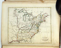
London.: Cradock and Joy (Successors to Mr. Ostell).. 1809.. Atlas 11 1/4 x 9 1/4 inches containing 30 maps with outline handcolor, including The World (double); 17 European nations; 4 Asia; 1 Africa; 3 North America (including United States); 1 South America; Chart of the World; 2 Ancient Geography (Greece and Roman Empire). Maps overall in good clean condition with occasional spotting but no toning to the paper; the map of the world has a couple of marks. Modest dark stain in margin of Switzerland; bleed-through of tape repair to Roman Empire. Binding is in poor condition: front cover detached; water staining to title page and contents page. North America, United States, and West Indies comprise the three maps pertaining to US interest. A nice collection of attractive copper plate engraved map with attractive outline handcolor. .
-
Bookseller
Independent bookstores
 (US)
(US)
- Book Condition Used
- Publisher Cradock and Joy (Successors to Mr. Ostell).
- Place of Publication London.
- Date Published 1809.
- Keywords Africa, Asia, Atlas, Europe, map, South America, world, zz_ListOn_eBay, zzbookg, zzmapg

Stock Photo: Cover May Be Different
A Robert Louis Stevenson Companion
by Hammond World Atlas Corporation Staff
- Used
- Condition
- Used - Good
- ISBN 10 / ISBN 13
- 9780029137901 / 002913790x
- Quantity Available
- 1
- Seller
-
Mishawaka, Indiana, United States
- Item Price
-
A$7.70
Show Details
Item Price
A$7.70

Stock Photo: Cover May Be Different
Presidents : An Illustrated History of America's Leaders
by Hammond World Atlas Corporation Staff
- Used
- Condition
- Used - Very Good
- ISBN 10 / ISBN 13
- 9780843718485 / 084371848x
- Quantity Available
- 1
- Seller
-
Mishawaka, Indiana, United States
- Item Price
-
A$7.70
Show Details
Description:
Hammond World Atlas Corporation. Used - Very Good. Former library book; may include library markings. Used book that is in excellent condition. May show signs of wear or have minor defects.
Item Price
A$7.70
Stock Photo: Cover May Be Different
Presidents : An Illustrated History of America's Leaders
by Hammond World Atlas Corporation Staff
- Used
- Condition
- Used - Good
- ISBN 10 / ISBN 13
- 9780843718485 / 084371848x
- Quantity Available
- 1
- Seller
-
Reno, Nevada, United States
- Item Price
-
A$7.70
Show Details
Description:
Hammond World Atlas Corporation. Used - Good. Former library book; may include library markings. Used book that is in clean, average condition without any missing pages.
Item Price
A$7.70
Stock Photo: Cover May Be Different
New Comparative World Atlas
by Hammond World Atlas Corporation Staff
- Used
- Condition
- Used - Good
- ISBN 10 / ISBN 13
- 9780843771008 / 0843771003
- Quantity Available
- 1
- Seller
-
Mishawaka, Indiana, United States
- Item Price
-
A$7.70
Show Details
Description:
Hammond World Atlas Corporation. Used - Good. Used book that is in clean, average condition without any missing pages.
Item Price
A$7.70

Stock Photo: Cover May Be Different
World Atlas, the Signet Hammond
by Hammond World Atlas Corporation Staff
- Used
- Condition
- Used - Good
- ISBN 10 / ISBN 13
- 9780451081506 / 0451081501
- Quantity Available
- 1
- Seller
-
Mishawaka, Indiana, United States
- Item Price
-
A$7.70
Show Details
Description:
Penguin Publishing Group. Used - Good. Used book that is in clean, average condition without any missing pages.
Item Price
A$7.70
Stock Photo: Cover May Be Different
A Robert Louis Stevenson Companion
by Hammond World Atlas Corporation Staff
- Used
- Condition
- Used - Good
- ISBN 10 / ISBN 13
- 9780029137901 / 002913790x
- Quantity Available
- 1
- Seller
-
Reno, Nevada, United States
- Item Price
-
A$7.70
Show Details
Description:
Cengage Gale. Used - Good. Used book that is in clean, average condition without any missing pages.
Item Price
A$7.70

Stock Photo: Cover May Be Different
World Atlas
by Hammond World Atlas Corporation Staff
- Used
- Condition
- Used - Good
- ISBN 10 / ISBN 13
- 9780843712957 / 0843712953
- Quantity Available
- 1
- Seller
-
Reno, Nevada, United States
- Item Price
-
A$7.70
Show Details
Description:
Cengage Learning. Used - Good. Used book that is in clean, average condition without any missing pages.
Item Price
A$7.70

Stock Photo: Cover May Be Different
Hammond Atlas of the 20th Century
by Hammond World Atlas Corp
- Used
- Condition
- Used - Good
- ISBN 10 / ISBN 13
- 9780843713589 / 0843713585
- Quantity Available
- 1
- Seller
-
Mishawaka, Indiana, United States
- Item Price
-
A$7.70
Show Details
Description:
Used - Good. Former library book; may include library markings. Used book that is in clean, average condition without any missing pages.
Item Price
A$7.70

Stock Photo: Cover May Be Different
Atlas of United States History
by Hammond World Atlas Corporation Staff
- Used
- Condition
- Used - Good
- ISBN 10 / ISBN 13
- 9780843711424 / 0843711426
- Quantity Available
- 1
- Seller
-
Mishawaka, Indiana, United States
- Item Price
-
A$7.70
Show Details
Description:
Hammond World Atlas Corporation. Used - Good. Used book that is in clean, average condition without any missing pages.
Item Price
A$7.70
Stock Photo: Cover May Be Different
Presidents : An Illustrated History of America's Leaders
by Hammond World Atlas Corporation Staff
- Used
- Condition
- Used - Good
- ISBN 10 / ISBN 13
- 9780843718485 / 084371848x
- Quantity Available
- 1
- Seller
-
Mishawaka, Indiana, United States
- Item Price
-
A$7.70
Show Details
Description:
Hammond World Atlas Corporation. Used - Good. Former library book; may include library markings. Used book that is in clean, average condition without any missing pages.
Item Price
A$7.70