Plan de la Ville de Paris et de Ses Faubourgs Dédié au Roi by Jaillot, Bernard
by Jaillot, Bernard
Plan de la Ville de Paris et de Ses Faubourgs Dédié au Roi
by Jaillot, Bernard
- Used
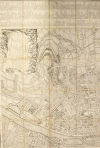
Rare 18th century map of the city of Paris and its environs, divided into four sheets of twenty sections each, mounted on canvas and folded, to make a large map of approximately 38-1/2 by 56-1/4 inches, dedicated to King Louis XV, with scale and explanation of abbreviations, each sheet with a three-column list of landmarks and places on the map, including streets, public squares, fountains, ports, bridges, chapels, colleges, hospitals, hôtels, royal houses, convents, markets, and other notable locations and sites, the map marked along the top and side with letters from B to Y and numbers from 1 to 16. Some spotting, redness, and foxing. Four sheets loose, housed in a cardboard slipcase with handwritten notation to spine, wear and chipping to case. Paris (Jaillot) 1767. With privilege 1748, corrected and augmented in 1765. The orientation of the map, with North to the left, is the same as that adopted by Jacques Gomboust in 1652 or Pierre Bullet in 1675. This system presents the western façades of churches and other important buildings to the viewer. In his 2007 work "Les Plans de Paris des origines (1493) à la fin du XVIIIe siècle", historian Jean Boutier cites eleven editions of this map, published between 1748 and 1787. According to Boutier at the time, no extant copies of the 1767 are known. In fact, while WorldCat lists other similar maps of Paris by Jaillot, as of October 2017 there is not a single listing for the 1767 edition.
-
Bookseller
Bernett Rare Books Inc
 (US)
(US)
- Book Condition Used
- Quantity Available 1
- Product_type