Description:
Paris: Hubert Jaillot, 1710. 803 by 560mm (31½ by 22 inches).. Kupferstichkarte, in zeitgenössischem Grenzkolorit. Mit großer, prächtiger, allegorischer Kartusche, sowie Meilenzeiger mit Legende. Erschienen im großen Atlas,Atlas Nouveau contenant... von Nicolaus Sanson u. Hubert Jaillot. Dargestellt wird der schwäbische Kreis im Norden mit dem benachbarten Franken u. im Süden bis zum Bodensee. Im Osten noch mit Teilen von Bayern, der Westen mit dem angrenzenden Frankreich. Das Kartenbild sorgfältig u. übersichtlich ausgearbeitet. Der, Atlas Nouveau.... entstand als Auftragsarbeitet für Ludwig XIV. und nahm einen Zeitraum von über 10 Jahren in Anspruch. Die Karten gelten bis heute noch als eine Meisterleistung der französischen Kartographie des 17.Jahrhunderts. Als Geburtsjahr Jaillots wird das Jahr 1632 angenommen, da in seiner Sterbeurkunde sein Alter mit 80 Jahren angegeben war. Der Geburtsort war Avignon-lès-Saint-Claude, damals ein kleiner Weiler in der Exklave der Freigrafschaft…
Read More Le Royaume DAngleterre, distingué en ses Provinces. Par le Sr. Sanson. Geographe du Roy. Presenté A Monseigneur Le Dauphin... A Paris Chez H.Iaillot 1693. by Jaillot, Alexis-Hubert & Sanson, N - 1693
by Jaillot, Alexis-Hubert & Sanson, N
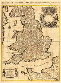
Le Royaume DAngleterre, distingué en ses Provinces. Par le Sr. Sanson. Geographe du Roy. Presenté A Monseigneur Le Dauphin... A Paris Chez H.Iaillot 1693.
by Jaillot, Alexis-Hubert & Sanson, N
- Used
Paris: H. Jaillot, 1693. Other. 757 by 582mm (29¾ by 23 inches).. Copper-engraving handcolored in outline, when published. Minor offsetting of the old outline colors to the paper. Printed around 1693 by Hubert Jaillot in Paris, printed from two plates and published in his great atlas the Atlas Noveau.... Large and decorative map of England by the French cartographer Nicolaus Sanson and Hubert Jaillot. Published in the 'Atlas Noveau...', this atlas was a masterpiece in the French cartography in the 17th century. The atlas was specially designed for Louis XIV and due of the very large size of the plates, most maps were printed from two plates, it took Hubert Jaillot over 12 years to complete the 'Atlas Noveau...'. England is very detailled shown on the map, as well the various counties are shown in engraved territory borders. The maps are rich in detail, with many cities and place names, rivers, mountains, castles, etc. The map is ornated with a very large fine allegoric title cartouche with coat of arms in the upper right corner, as well a decorative cartouche with a milage scale in the lower left corner. In very good condition. 757 by 582mm (29¾ by 23 inches).
-
Bookseller
Antiquariat Reinhold Berg ek
 (DE)
(DE)
- Format/Binding Other
- Book Condition Used
- Quantity Available 1
- Publisher H. Jaillot
- Place of Publication Paris
- Date Published 1693
- Keywords Antique map Map:Europe:Great Britain:England England Jaillot, Alexis-Hubert & Sanson, N. Le Royaume DAngleterre, distingué en ses Provinces. Par le Sr. Sanson. Geographe du Roy. Presenté A Monseigneur Le Dauphin... A Paris Chez H.Iaillot 1693. Paris
- Product_type map
- Size 757 by 582mm (29¾ by 23 inches).
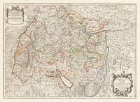
Le Cercle de Souabe, subdivisé en tous les Estats qui le Composent Tire ´sur les Memoires les plus noueaux Par le S. Sanson Geographe Ordinaire du Roy. A Paris, Ches H. Laillot joingnant les Augustins, aux deux Globes Auec Priuilege du Roy, pour Vingt Ans.
by Jaillot, Alexis-Hubert & Sanson, N
- Used
- Condition
- Used
- Quantity Available
- 1
- Seller
-
Regensburg, Germany
- Item Price
-
A$740.61
Show Details
Item Price
A$740.61
