
Click for full-size.
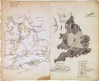
The Saxon Heptarchy. England and Wales
by ANONYMOUS [Manuscript map]
- Used
- Condition
- See description
- Seller
-
New York, New York, United States
Payment Methods Accepted
About This Item
Map. Pen and ink with watercolor. Sheet measures 7 x 8.5".<br/><br/> This beautiful schoolgirl or schoolboy manuscript map of England and Wales beautifully depicts from Scotland south to the English Channel. Essentially two maps on a single sheet, the left map depicts the region with detailed topography throughout. Towns, rivers and mountains are noted with a key in the top left corner. The right hand side of the map depicts "The Saxon Heptarchy" and territories are numbered and shaded in. A key in the bottom right lists the territories numbered on the map. The Wall of Severus is identified. The speculative Wall of Severus was supposedly built by the Roman Emperor Septimius Severus as a defensive fortification, but was most likely mistaken for either the Antonine Wall or the Hardian's Wall. The map is in good condition with minor wear along the original centerfold. Small stain in the bottom of centerfold. Minor toning and foxing with some edge wear.<br><br>This map dates to circa 1880 and was most likely made by a student or apprentice as training in geography, drafting, and penmanship. Manuscript map-making was a useful educational tool in the 19th century, a period of imperialism and increased world trade in which geography grew significantly as a field of study.<br><br>In the United States and northwestern Europe, reform movements that sought to improve the quality and accessibility of childhood education pushed for the inclusion of geography in school curricula. One common method of teaching was the making of manuscript maps. Working from wall maps, globes, and atlases, students were made to meticulously hand-reproduce maps in pen and ink and with watercolor. Such exercises not only provided a way to review and retain geographical knowledge, but they also functioned as training in penmanship, calligraphy, and drafting. This map is a lovely document that straddles the line between art and geography.<br/><br/>
Reviews
(Log in or Create an Account first!)
Details
- Bookseller
- Argosy Book Store
 (US)
(US)
- Bookseller's Inventory #
- 267849
- Title
- The Saxon Heptarchy. England and Wales
- Author
- ANONYMOUS [Manuscript map]
- Book Condition
- Used
- Quantity Available
- 1
- Keywords
- manuscript, amateur, England, Wales, Classical
Terms of Sale
Argosy Book Store
All items are offered net, subject to prior sale. Returns accepted within 7 days of receipt--please contact us first. Payment by Visa , Mastercard & American Express. Appropriate sales tax will be added for all N.Y. State residents
About the Seller
Argosy Book Store
Biblio member since 2004
New York, New York
About Argosy Book Store
We are a large retail store, with 6 floors of out-of-print and rare books, (including, Americana, modern first editions, history of medicine and science), antique maps and prints, autograph manuscripts, letters & signatures.
Glossary
Some terminology that may be used in this description includes:
This Book’s Categories

The Great Formosa Hoax
George Psalmanazar played a grand prank in 1703, pretending to be a resident of the island of Formosa. His book took London by storm. Learn more...

Storing books - laying down or standing up?
Don’t unwittingly damage your growing book collection! Learn about when to store books laying down vs standing up. Read About Safe Book Storage