Description:
Chilton Book Company, 1995-11. Hardcover. Good.
(West Canada, Lake Huron & Lake Ontario) by Smith, J. Calvin - 1845
by Smith, J. Calvin
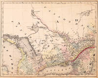
(West Canada, Lake Huron & Lake Ontario)
by Smith, J. Calvin
- Used
Cassel: Th. Fischer, 1845. Other. 373 by 479mm (14¾ by 18¾ inches).. Lithograph, original color in outline and wash. This decorative map shows the region from West Canada, Ottawa River towards East Canada. Detailed information on the map on Lake Ontario, the Georgian Bay, Nipissing Lake, Temiscaming Lake and the Ottawa River. Inside the map are many place names, rivers, lakes, etc. engraved. As well names on Indian tribes are given. This is one sheet (map no 3) of Calvin Smiths famous map of North America. Here is the rare version in lithograph present, published in Cassel in Germany. A splendid detailed map, showing nicely West Canada, Lake Huron and Lake Ontario and adjacenting parts. The map is highly detailed colored in outline and wash by counties and states, many place names, streets or routes, rivers, mountains, etc. are shown. An interesting collectors piece. In very good to excellent condition. A few small marginal mended tears at the blank bottom (not affecting the image of the map) and a few minor marginal pin holes.
-
Bookseller
Antiquariat Reinhold Berg ek
 (DE)
(DE)
- Format/Binding Other
- Book Condition Used
- Quantity Available 1
- Publisher Th. Fischer
- Place of Publication Cassel
- Date Published 1845
- Keywords Antique map Map:Americas:Canada Canada Smith, J. Calvin (West Canada, Lake Huron & Lake Ontario) Cassel Th. Fischer 1845
- Product_type map
- Size 373 by 479mm (14¾ by 18¾ inches).

Stock Photo: Cover May Be Different
Chilton's Truck and Van Manual 1992-96 (Chilton's Truck and Van Service Manual)
by Editor-Kerry A. Freeman; Editor-Dean F. Morgantini; Editor-W. Calvin Settle; Editor-Nicholas L. D'Andrea; Editor-Debra Gaffney; Editor-Jacques Gordon; Editor-Michael L. Grady; Editor-Kevin M. G. Maher; Editor-Richard J. Rivele; Editor-Richard T. Smith
- Used
- good
- Hardcover
- Condition
- Used - Good
- Binding
- Hardcover
- ISBN 10 / ISBN 13
- 9780801979187 / 0801979188
- Quantity Available
- 1
- Seller
-
HOUSTON, Texas, United States
- Item Price
-
A$15.59
Show Details
Item Price
A$15.59

Chilton's Auto Repair Manual 1992-1996 (Chilton's Auto Service Manual)
by Editor-Kerry A. Freeman; Editor-Dean F. Morgantini; Editor-W. Calvin Settle; Editor-Nicholas L. D'Andrea; Editor-Debra Gaffney; Editor-Jacques Gordon; Editor-Michael L. Grady; Editor-Kevin M. G. Maher; Editor-Richard J. Rivele; Editor-Richard T. Smith
- Used
- good
- Hardcover
- Condition
- Used - Good
- Binding
- Hardcover
- ISBN 10 / ISBN 13
- 9780801979163 / 0801979161
- Quantity Available
- 1
- Seller
-
HOUSTON, Texas, United States
- Item Price
-
A$19.69
Show Details
Description:
W G Nichols Pub, 1995-11. Hardcover. Good.
Item Price
A$19.69
The Donald J. Arnold Symposium on Medical Physics (The Texas Journal of Science, Vol. 40, No. 2, May 1988). INCLUDES: The Role of Medical Physics in Radiology; Dynamic Radiation Therapy Using Negative Pi-Mesons; Theoretical Acquisition of X-Ray Spectra in Diagnostic Radiology; Instrumentation for Radiation Measurement; High-Dose-Rate Remote Afterloader - A New Approach in Radioactive Implant Therapy; Magnetic Resonance Imaging; One English Physicists View of the Place of Physics in a Hospital Setting.
by Lodhi, M. A. K.; Alfred R. Smith, Patrick M. Stafford, Morton M. Kligerman, J. Michael Collier and Howard J. Amols; Benjamin R. Archer, Louis K. Wagner and Thomas R. Fewell; Leroy J. Humphries; Saiyid M. Shah; Calvin P. Meyers and James K. Fisher; W. Harr
- Used
- very good
- Paperback
- Condition
- Used - Very Good
- Binding
- Paperback
- Quantity Available
- 1
- Seller
-
Stephenville, Texas, United States
- Item Price
-
A$15.42
Show Details
Description:
The Texas Journal of Science., 1988. Journal. Very Good. Soft cover. ORIGINAL JOURNAL; published symposium volume on medical physics; softcover; in very good condition. .
Item Price
A$15.42
Crazy Buffet BBQ Edition: A Second Helping Of Stories
by Kirkland, J. Smith/ Beam, Calvin/ Riley, Kelle Z./ Sedlacek, Gary/ David, Elijah/ Petrie, Joe/ Harwood, Jerry/ Shannon, Riley C./ Bankstone, Marcus Brian/ Kirkland, J. Smith
- New
- Paperback
- Condition
- New
- Binding
- Paperback
- ISBN 10 / ISBN 13
- 9781652835592 / 1652835598
- Quantity Available
- 1
- Seller
-
Exeter, Devon, United Kingdom
- Item Price
-
A$17.37
Show Details
Description:
Independently published, 2019. Paperback. New. 154 pages. 8.00x5.25x0.39 inches.
Item Price
A$17.37

Stock Photo: Cover May Be Different
The Illustrated Hand-Book: A New Guide for Travelers Through the United States of America: Containing a Description of the States, Cities, Towns, ... Railroad, Stage, and Steamboat Routes, The...
by Smith, J Calvin
- Used
- Condition
- UsedVeryGood
- ISBN 10 / ISBN 13
- 9781275861565 / 1275861563
- Quantity Available
- 1
- Seller
-
Bensalem, Pennsylvania, United States
- Item Price
-
A$40.14
Show Details
Description:
UsedVeryGood. signs of little wear on the cover.
Item Price
A$40.14
Stock Photo: Cover May Be Different
The Illustrated Hand-Book: A New Guide for Travelers Through the United States of America: Containing a Description of the States, Cities, Towns, ... Railroad, Stage, and Steamboat Routes, The...
by Smith, J Calvin
- Used
- Condition
- UsedLikeNew
- ISBN 10 / ISBN 13
- 9781275861565 / 1275861563
- Quantity Available
- 1
- Seller
-
Bensalem, Pennsylvania, United States
- Item Price
-
A$40.55
Show Details
Description:
UsedLikeNew. Remainder mark
Item Price
A$40.55
Civil War Maps of the Southern States
by J. Calvin Smith
- Used
- as new
- Condition
- As New
- Jacket Condition
- No Jacket
- Quantity Available
- 1
- Seller
-
Lancaster, Pennsylvania, United States
- Item Price
-
A$30.99
Show Details
Description:
Cincinnati, OH: Kag Industries. No Binding. As New/No Jacket. Nine folded maps, reproduced by Kag Industries. 15-1/2" x 19" each.
Item Price
A$30.99
Calvin: Commentaries: newly trans & edited (Library of Christian classics Vol XXIII)
by HAROUTUNIAN J & SMITH [CALVIN]
- Used
- Hardcover
- Condition
- Used
- Binding
- Hardcover
- Quantity Available
- 1
- Seller
-
SALISBURY, Wiltshire, United Kingdom
- Item Price
-
A$12.60
Show Details
Description:
Westminster Press 1958 Westminster Pr 1958 414pp HARDBACK, bright binding, wrapper edge-rubbed/chipped, considerable amount of pencil underlinings/marginal annotations and 4 pages with some highlighting, tightly bound, quality paper Very Good
Item Price
A$12.60

Chilton book company repair & tune-up guide, Toyota Corona/Crown/ Cressida/Mark II/Van, 1970-86 : all U.S. and Canadian models. [Chilton's fuel economy & tune-up tips; Chilton's auto body repair tips]
by Baxter, John; [eds., Richard J. Rivele, Jacques Gordon, Michael L. Grady, Debra McCall, Kevin G. M. Maher, Richard T. Smith, Jim Taylor, Ron Webb, Nick D'Andrea, Dean Morgantini, W. Calvin Settle]
- Used
- as new
- Condition
- As New
- ISBN 10 / ISBN 13
- 9780801976742 / 080197674X
- Quantity Available
- 1
- Seller
-
Stockbridge, Georgia, United States
- Item Price
-
A$29.44
Show Details
Description:
Radnor, PA. : Chilton, 1987., 1987. As New. 220 pp., [16] pp. of plates : illustrations (some in color) ; 26 cm. ; ISBN: 080197674X ; LCCN: 85-47976 ; OCLC: 16015164 ; Dewey: 629.28/722 ; "Chilton's fuel economy & tune-up tips" ([8] p.) inserted between p. [92]-93; "Chilton's auto body repair tips" ([8] p.) inserted between p. 188-189./ "Part no. 7044"--Spine. ; color pcitorial stiff paper wrappers ; a few bumps, foxing, else AS NEW
Item Price
A$29.44
The Illustrated Hand-book, a New Guide for Travelers Through the United States of America: Containing a Description of the States, Cities, Towns, ... Stage, and Steamboat Routes, the Distanc
by J. Calvin (John Calvin) Smith
- Used
- good
- Paperback
- Condition
- Used - Good
- Binding
- Paperback
- ISBN 10 / ISBN 13
- 9781290115582 / 1290115583
- Quantity Available
- 1
- Seller
-
HOUSTON, Texas, United States
- Item Price
-
A$47.13
Show Details
Description:
HardPress Publishing, 2012-01-10. Paperback. Good.
Item Price
A$47.13
