Description:
Vancouver: Pulp Press, 1981. First edition. An illustrated poetry broadside, a single sheet measuring 11 X 17 inches. Printed in brown on tan paper. A poem from the book Breaking The Silences, translated by Margaret Randall. Fine condition. Morejon is a Cuban poet.
Search Results: Authors starting with N from William Matthews, Bookseller / The Haunted Bookshop
You searched for:
- Bookseller inventory: William Matthews, Bookseller / The Haunted Bookshop (authors starting with N)
- Bookseller: William Matthews, Bookseller / The Haunted Bookshop
Results 1 - 20 of 57

Woman In A Tobacco Factory.
by Morejon (Nancy)
- Used
- Condition
- Used
- Quantity Available
- 1
- Seller
-
Sidney, British Columbia, Canada
- Item Price
-
A$69.77A$27.91 shipping to USA
Show Details
Item Price
A$69.77
A$27.91
shipping to USA

History of the Prehistoric Ages: Written by the Ancient Historic Band of Spirits, Through the Hand of Leonard Herbert Nason, of Chicago, Ill. And Translated by James Cooper, M.D., of Bellefontaine, O.
by Nason (Leonard Herbert) & James Cooper, M.D.
- Used
- Hardcover
- Condition
- Used
- Binding
- Hardcover
- Quantity Available
- 1
- Seller
-
Sidney, British Columbia, Canada
- Item Price
-
A$193.81A$27.91 shipping to USA
Show Details
Description:
Chicago: C.E. Southard, Printer, 1880. First edition.. cat40a. 390pp. Green blind-stamped cloth, spine ruled and lettered in gilt. Tan end papers. Frontispiece portrait of L.H. Nason. A bright, very good copy. A chronology of the Earth and civilization, including Atlantis. Not in Wright. Not in the Charvat Database. Listed in the LC Online Catalog, but stating [n.p.]: 1880 - no publisher or place listed. Concerns Atlantis, portions are presented in fictional form. Predates Donnelly.
Item Price
A$193.81
A$27.91
shipping to USA
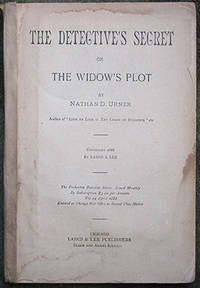
The Detective's Secret or The Widow's Plot.
by Urner (Nathan D.)
- Used
- Condition
- Used
- Quantity Available
- 1
- Seller
-
Sidney, British Columbia, Canada
- Item Price
-
A$69.77A$27.91 shipping to USA
Show Details
Description:
cat40a. Chicago: Laird & Lee, 1888. 110pp. plus 10 pages of ads at rear. First edition. Original wrappers, front cover missing, spine covered in heavy brown tape. Old stain to lower corner, the upper back cover and last few leaves are chipped in the margins; a good copy at best. Issued in The Pinkerton Detective Series, Vol. 14, April 1888. Listed in Hubin, who mentions that Urner also wrote for Street & Smith under the pseudonym: Burke Brentford.
Item Price
A$69.77
A$27.91
shipping to USA

England - South Coast. Approaches to Spithead.
by England Nautical Chart
- Used
- Condition
- Used
- Quantity Available
- 1
- Seller
-
Sidney, British Columbia, Canada
- Item Price
-
A$193.81A$27.91 shipping to USA
Show Details
Description:
London: British Admiralty, 1896 (1927).. A large engraved chart on heavy stock, uncolored, sheet size 44 x 28 inches. Published 1896; New Edition 1927. Small corrections to 1927 (printed) and 1932 (mss.). Original vertical folds, a very clean copy; numerous corrections and additions in red, and two printed paste-over corrections. In lower right: "Zp1927". Chart number is 2050. Small typed label on verso giving chart & folio info. Published under the Superintendence of Rear Admiral W.J.L. Wharton. Engraved coastlnes at bottom. Good close-up detail of the Isle of Wight.
Item Price
A$193.81
A$27.91
shipping to USA
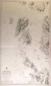
North America - West Coast. British Columbia. Edye Passage to Portland Inlet.
by BC Nautical Chart
- Used
- Condition
- Used
- Quantity Available
- 1
- Seller
-
Sidney, British Columbia, Canada
- Item Price
-
A$155.05A$27.91 shipping to USA
Show Details
Description:
London: British Admiralty, 1912 (1925).. An engraved chart on heavy stock, uncolored, sheet size 26.5 x 44 inches. Originally published 1912, this is an edition of 1925, with mss. corrections to 1928. Original horizontal folds, a nice clean copy, some small corrections in red. At lower right: "Engraved by Weller & Addison". Chart number is 1737. Small typed label on verso, giving chart & folio information. Produced under the Superintendence of Rear Admiral H.E. Parry. Good detail of the Dundas Islands, Chatham Sound.
Item Price
A$155.05
A$27.91
shipping to USA
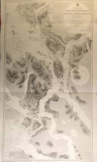
North America - West Coast. British Columbia. Browning Entrance to Prince Rupert Harbour.
by BC Nautical Chart
- Used
- Condition
- Used
- Quantity Available
- 1
- Seller
-
Sidney, British Columbia, Canada
- Item Price
-
A$193.81A$27.91 shipping to USA
Show Details
Description:
London: British Admiralty, 1913 (1928).. An engraved chart on heavy stock, uncolored, sheet size 28 x 46 inches. Originally published 1913, this is a New Edition of 1920 with printed Small corrections to 1928. Original horizontal folds, a nice clean copy, some small corrections in red. At lower right: "Engraved by Davies & Company". Chart number is 2453. Small typed label on verso, giving chart & folio information. Produced under the Superintendence of Rear Admiral H.E. Purey-Cust. A large-scale chart, Prince Rupert at the top, extending south to Banks Island.
Item Price
A$193.81
A$27.91
shipping to USA

British Columbia. Vancouver Island. Nanaimo Harbour.
by BC Nautical Chart
- Used
- Condition
- Used
- Quantity Available
- 1
- Seller
-
Sidney, British Columbia, Canada
- Item Price
-
A$155.05A$27.91 shipping to USA
Show Details
Description:
Ottawa: Hydrographic and Map Service, 1939 (Small corrections in mss. to 1944). An engraved chart, 4-colour, on heavy stock. Sheet size is 31.5 x 28.5 inches. Original horizontal fold, a nice clean copy, a few small marks in red pen. Chart number is 381. This is the 1939 first edition, with mss. Small corrections to 1944. Red ink stamp on verso indicating chart and folio information. The coast at Nanaimo, showing Protection Island and Newcastle Island.
Item Price
A$155.05
A$27.91
shipping to USA

North America - West Coast. British Columbia. Plans of Anchorages in Queen Charlotte Islands. [Haida Gwaii].
by BC Nautical Chart
- Used
- Condition
- Used
- Quantity Available
- 1
- Seller
-
Sidney, British Columbia, Canada
- Item Price
-
A$155.05A$27.91 shipping to USA
Show Details
Description:
London: British Admiralty, 1924.. An engraved chart on heavy stock, uncolored, sheet size 40 x 27.5 inches. Published 1924, this has mss. Small corrections to 1927. Original vertical fold, a nice clean copy, some small corrections in red, and one paste-over correction. At lower right: "Engraved by Davies & Company". Chart number is 3711. Small typed label on verso, giving chart & folio information. Produced under the Superintendence of Vice Admiral Fredk. C. Learmonth. The right half of this chart is blank; the left side is one large chart: Graham Island - North Coast. Masset Sound and Inlet. [Haida Gwaii].
Item Price
A$155.05
A$27.91
shipping to USA
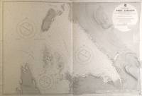
North America - West Coast. British Columbia. Port Simpson.
by BC Nautical Chart
- Used
- Condition
- Used
- Quantity Available
- 1
- Seller
-
Sidney, British Columbia, Canada
- Item Price
-
A$155.05A$27.91 shipping to USA
Show Details
Description:
London: British Admiralty, 1907 (1923).. An engraved chart on heavy stock, uncolored, sheet size 40 x 27.5 inches. Originally published 1907, this is an edition with printed Small corrections to 1923. Original vertical fold, a nice clean copy, some small corrections in red. At lower right: "Engraved by Davies & Company". Chart number is 3678. Small typed label on verso, giving chart & folio information. Produced under the Superintendence of Rear Admiral A. Mostyn Field. Detail of Port Simpson, showing the location of totem poles, the Indian Burial Ground, the Chief's house.
Item Price
A$155.05
A$27.91
shipping to USA
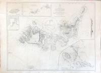
Pacific Ocean. Sakisima Islands. Miyako Jima and Yayeyama Groups.
by Japan Nautical Chart
- Used
- Condition
- Used
- Quantity Available
- 1
- Seller
-
Sidney, British Columbia, Canada
- Item Price
-
A$155.05A$27.91 shipping to USA
Show Details
Description:
London: British Admiralty, 1852 (1927).. An engraved chart on heavy stock, uncolored, sheet size 27.5 x 20 inches. Published 1852, Large Corrections to 1889, Small corrections to 1927 (printed) and 1934 (mss.). Unfolded. A very good copy, some additions in red and routes marked in pencil. A printed paste-over comprises some of the central corrections. In lower right: "J & C. Walker, Sculpt.". Chart number is 2105. Small typed label on verso giving chart & folio info. Inset maps of Kumi, Port Broughton, Sakisima Islands, and the Miyako Jima Group. [Wiki]: Miyako Island is the largest and the most populous island among the Miyako Islands of Okinawa Prefecture, Japan. Miyako Island is administered as part of the City of Miyakojima, which includes not only Miyako Island, but also five other populated islands.
Item Price
A$155.05
A$27.91
shipping to USA

More Photos
Plans Of Air Bases. (Southern B.C. Coast).
by BC Nautical Chart
- Used
- Condition
- Used
- Quantity Available
- 1
- Seller
-
Sidney, British Columbia, Canada
- Item Price
-
A$387.62A$27.91 shipping to USA
Show Details
Description:
Ottawa: Hydrographic and Map Service, 1943. First edition.. An engraved chart, uncolored, on heavy stock. Sheet size is 42 x 30.5 inches. Original vertical & horizontal folds, a nice clean copy. Charts of four air bases in Southern BC: Stephens Bay, Ucluelet, Jericho Beach, and Sea Island. The chart is marked "Confidential" at lower right, which has been crossed out in red pen and "Restricted" written in, with the date 1-1-45. Chart number is C-3401. Red ink stamp on verso indicating chart and folio information.
Item Price
A$387.62
A$27.91
shipping to USA

England - South Coast. Portland to Owers.
by England Nautical Chart
- Used
- Condition
- Used
- Quantity Available
- 1
- Seller
-
Sidney, British Columbia, Canada
- Item Price
-
A$155.05A$27.91 shipping to USA
Show Details
Description:
London: British Admiralty, 1880 (1927).. An engraved chart on heavy stock, uncolored, sheet size 40 x 27.5 inches. Published 1880; New Edition 1922. Small corrections to 1927 (printed) and 1933 (mss.). Original vertical fold, a very good copy, some small additions in red pen, and several small paste-over corrections. In lower right: "Engraved by Weller & Addison" and "Zc 1927". Chart number is 2450. Small typed label on verso giving chart & folio info. Published under the Superintendence of Captain F.J. Evans. Coastal engraving at the bottom.
Item Price
A$155.05
A$27.91
shipping to USA

England - South and West Coasts. Trevose Head to Dodman Point Including The Scilly Isles.
by England Nautical Chart
- Used
- Condition
- Used
- Quantity Available
- 1
- Seller
-
Sidney, British Columbia, Canada
- Item Price
-
A$155.05A$27.91 shipping to USA
Show Details
Description:
London: British Admiralty, 1888 (1928). An engraved chart on heavy stock, uncolored, sheet size 27.5 x 40 inches. Published 1888; New Edition 1920; Large corrections to 1928 (printed) and 1933 (mss.). Original vertical fold, a clean copy; some corrections and additions in red. In lower right: "Engraved 1888" and "Zc 1928". Chart number is 2565. Small typed label on verso giving chart & folio info. Published under the Superintendence of Captain W.J.L. Wharton. Engraved coastline at the bottom. Cornwall and the Scilly Islands.
Item Price
A$155.05
A$27.91
shipping to USA
More Photos
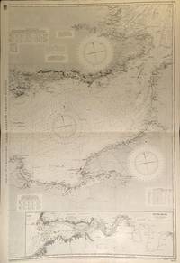
English Channel. In Three Sheets.
by England Nautical Chart
- Used
- Condition
- Used
- Quantity Available
- 1
- Seller
-
Sidney, British Columbia, Canada
- Item Price
-
A$387.62A$27.91 shipping to USA
Show Details
Description:
London: British Admiralty, 1885 (1928 - 1931). The set of three engraved charts on heavy stock, uncolored, sheet size of each is 27.5 x 40 inches. Published 1885; Small corrections to 1928 and 1931 (printed) and 1933 (mss.). Original horizontal folds, clean and very good, with some wear to the edges of the Middle Sheet, numerous small additions in red. In lower right corners are engraving dates & details. Chart numbers are 2675a, 2675b, and 2675c. Small typed label on versos giving chart & folio info. Published under the Superintendence of Captain W.J.L. Wharton. The Eastern Sheet has an inset map of the River Seine.
Item Price
A$387.62
A$27.91
shipping to USA

British Columbia. Fraser River. Sheet 1. Sand Heads to Steveston.
by BC Nautical Chart
- Used
- Condition
- Used
- Quantity Available
- 1
- Seller
-
Sidney, British Columbia, Canada
- Item Price
-
A$77.52A$27.91 shipping to USA
Show Details
Description:
Ottawa: Hydrographic and Map Service, 1943 (Small corrections to 1943).. An engraved chart, uncolored, on heavy stock. Sheet size is 40 x 22 inches. Original vertical fold, a clean copy, a few small marks in red pen, some dust soiling at lower edge. Chart number is 3429. First published in 1930; this is the 1943 edition with printed Small corrections to 1943. Red ink stamp on verso indicating chart and folio information.
Item Price
A$77.52
A$27.91
shipping to USA

Plymouth Sound & Hamoaze.
by England Nautical Chart
- Used
- Condition
- Used
- Quantity Available
- 1
- Seller
-
Sidney, British Columbia, Canada
- Item Price
-
A$193.81A$27.91 shipping to USA
Show Details
Description:
London: British Admiralty, 1899 (1932).. A large engraved chart on heavy stock, uncolored, sheet size 31 x 45 inches. Published 1889; New Edition 8th Jan. 1923. Large Corrections to March 1931; Small corrections to 1932 (printed) and 1933 (mss.). Original vertical and horizontal folds, a very clean and attractive copy, some small additions in red pen. In lower right: "Engraved 1899 / Processed 1925". Chart number is 30. Small typed label on verso giving chart & folio info. Published under the Superintendence of Rear Admiral Sir W.J.L. Wharton. Numerous small engravings of shorelines and beacons at the bottom. A large and very detailed chart, twice folded.
Item Price
A$193.81
A$27.91
shipping to USA
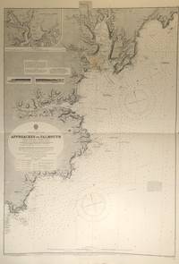
England - South Coast. Approaches to Falmouth.
by England Nautical Chart
- Used
- Condition
- Used
- Quantity Available
- 1
- Seller
-
Sidney, British Columbia, Canada
- Item Price
-
A$155.05A$27.91 shipping to USA
Show Details
Description:
London: British Admiralty, 1872 (1927).. An engraved chart on heavy stock, uncolored, sheet size 27.5 x 40 inches. Published 1872; New Edition 1915. Small corrections to 1927 (printed) and 1932 (mss.). Original horizontal fold, a very clean copy, some small additions in red pen and one small paste-over correction. In lower right: "Engraved by Davies Bryer & Co." and "Zc 1925". Chart number is 154. Small typed label on verso giving chart & folio info. Published under the Superintendence of Rear Admiral G.H. Richards. Several inset engravings of shorelines, and an inset map of Truro.
Item Price
A$155.05
A$27.91
shipping to USA

British Columbia. Vancouver Harbour. Sheet 3 (Second Narrows to Port Moody).
by BC Nautical Chart
- Used
- Condition
- Used
- Quantity Available
- 1
- Seller
-
Sidney, British Columbia, Canada
- Item Price
-
A$116.29A$27.91 shipping to USA
Show Details
Description:
Ottawa: Hydrographic and Map Service, 1942 (Small corrections to 1943).. An engraved chart, 4-color, on heavy stock. Sheet size is 42 x 28.5 inches. Original vertical fold, a very clean copy, a few small red marks in pen. Two small paste-on corrections on the coast near Port Moody. Chart number is 334. First published in 1930; this is the October, 1942 Edition, with printed Small corrections to 1943. Red ink stamp on verso indicating chart and folio information.
Item Price
A$116.29
A$27.91
shipping to USA

British Columbia. Fraser River. Sheet 2. Steveston to Tilbury Island.
by BC Nautical Chart
- Used
- Condition
- Used
- Quantity Available
- 1
- Seller
-
Sidney, British Columbia, Canada
- Item Price
-
A$77.52A$27.91 shipping to USA
Show Details
Description:
Ottawa: Hydrographic and Map Service, 1944 (Small corrections to 1945).. An engraved chart, uncolored, on heavy stock. Sheet size is 40 x 22 inches. Original vertical fold, a clean copy, a few small marks in red pen. Chart number is 3430. First published in 1930; this is the Nov. 1, 1944 edition with printed Small corrections to 1945. Red ink stamp on verso indicating chart and folio information.
Item Price
A$77.52
A$27.91
shipping to USA
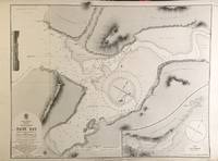
North America - West Coast. British Columbia. Nass Bay.
by BC Nautical Chart
- Used
- Condition
- Used
- Quantity Available
- 1
- Seller
-
Sidney, British Columbia, Canada
- Item Price
-
A$155.05A$27.91 shipping to USA
Show Details
Description:
London: British Admiralty, 1872 (1915).. An engraved chart on heavy stock, uncolored, sheet size 27.5 x 20 inches. Originally published 1872, this is a New Edition of 1915, No folds, a very good copy, some wear and wrinkling to lower edge. At lower right: "Engraved by Davies, Bryer & Co.". Chart number is 2190. Small typed label on verso, giving chart & folio information. Produced under the Superintendence of Rear Admiral G.H. Richards. The lower right is an inset map of the Nass River. Engraved shoreline inset at upper left.
Item Price
A$155.05
A$27.91
shipping to USA

Didn’t find what you’re looking for?
Try adding this search to your want list. Millions of books are added to our site everyday and when we find one that matches your search, we’ll send you an email. Best of all, it’s free.
Add to Want List

Are you a frequent reader or book collector?
Join the Bibliophile's Club and save 10% on every purchase, every day — up to $20 savings per order!

Social Responsibility
Did you know that since 2004, Biblio has used its profits to build 16 public libraries in rural villages of South America?
