Description:
Vanity Fair, June 13, 1891. Drawn by Spy. Original chromolithograph. Page size approx. 38 x 26.5cm. Image size approx. 32 x 19cm. With original leaf of biographical text.
Search Results: Titles starting with B from Robert Frew Ltd
You searched for:
- Bookseller inventory: Robert Frew Ltd (titles starting with B)
- Bookseller: Robert Frew Ltd
Results 1 - 20 of 317

B". Men of the Day. No. 510.
by BANCROFT, Squire Bancroft, Mr.
- Used
- Condition
- Used
- Quantity Available
- 1
- Seller
-
London, London, United Kingdom
- Item Price
-
A$48.46A$17.35 shipping to USA
Show Details
Item Price
A$48.46
A$17.35
shipping to USA
![(BERKSHIRE). A Topographical Survey of the County of Berks in Eighteen Sheets...[with] A Map of...](https://d3525k1ryd2155.cloudfront.net/h/109/199/1401199109.0.m.jpg)
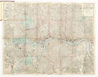
(BERKSHIRE). A Topographical Survey of the County of Berks in Eighteen Sheets...[with] A Map of the County of Berks Reduced from an Actual Survey in 18 Sheets, by the late John Rocque Topographer to His Majesty, 1762.
by ROCQUE, John, & ROCQUE, Mary Anne.
- Used
- Hardcover
- Condition
- Used
- Binding
- Hardcover
- Quantity Available
- 1
- Seller
-
London, London, United Kingdom
- Item Price
-
A$13,082.85A$17.35 shipping to USA
Show Details
Description:
London: Published according to Act of Parliament by John Rocque Chrographer to his Majesty [and] Mary Anne Rocque, 1761 and 1762 respectively.. Original hand-coloured map engraved by Richard Benning and L.F. Deharme (dated 1761) on 18 sheets folio (4 single page 53 x 40 cm. and 14 double page 53 x 76 cm, complete. If joined would measure 1625 x 2730 cm), plus the key map entitled "... Map of the County of Berks reduced from the Actual Survey in 18 Sheets" (published by Mary Anne Rocque and dated 1762, also with original hand-colour). Nineteenth century half burgundy morocco over brown cloth. The large map complete but the whole work bound without the printed title or the 12 page index. Repair in outer margin of first leaf (engraved dedication, plate 15 of the whole map) and minor marginal dampstain, similarly plate one of the map, corner crease to general map, the remainder generally very fresh and clean. An uncommon map and rare in original colour, including the additional reduced key map.
Item Price
A$13,082.85
A$17.35
shipping to USA

(BERN) Spezialharte des Exkursionsgebietes von Bern. Herausgegeben unter Mitwurkung des Verkehrs-Verein Bern. bearbeitet vin H. K�mmerly & Frey, geogr. artist Anstalt Bern.
by K�MMERLY, H.
- Used
- Hardcover
- Condition
- Used
- Binding
- Hardcover
- Quantity Available
- 1
- Seller
-
London, London, United Kingdom
- Item Price
-
A$96.91A$17.35 shipping to USA
Show Details
Description:
Bern: Geographischer Karten Verlag 1908.. Colour printed map (overall 67 x 88 cm.), dissected into 21 panels, backed onto cloth with one pictorial paper cover printed in blue.
Item Price
A$96.91
A$17.35
shipping to USA
![[BORNEO]. Operational Navigation Chart (ONC). L-11. Brunei, Indonesia, Malaysia, Philippines.](https://d3525k1ryd2155.cloudfront.net/h/951/165/1498165951.0.m.jpg)
[BORNEO]. Operational Navigation Chart (ONC). L-11. Brunei, Indonesia, Malaysia, Philippines.
by UNITED STATES AIR FORCE.
- Used
- Condition
- Used
- Quantity Available
- 1
- Seller
-
London, London, United Kingdom
- Item Price
-
A$969.10A$17.35 shipping to USA
Show Details
Description:
Saint Louis: Aeronautical Chart and Information Center, 1966.. 2 maps (104.5 x 77 cm) printed back to back in colour on a single sheet of rayon (artificial silk), marked "For official use only " in red. The north eastern half of Borneo including Brunei printed on one side, the south western side on the reverse. Scale 1:1,000,000. Faintly toned along outer margins with some light spotting to bottom corner, generally a very good example. The Escape and Evasion / Operational Navigational Charts (ONCs) were produced by the American Aeronuatical Chart and Information Center on a scale of 1:1,000,000, designed for pilots to identify topographical features but also as Escape and Evasion maps for downed crew. They are made of artificial silk to be tough, quiet and resilient and to be easily folded and pocketed or otherwise hidden. "Base information compiled September 1966 from source dated September 1966." "This chart is reproduced from ONC L-11 3rd Edn."
Item Price
A$969.10
A$17.35
shipping to USA
![[BULLFIGHTING].](https://d3525k1ryd2155.cloudfront.net/h/314/508/1472508314.0.m.jpg)
[BULLFIGHTING].
by LEGRAND, C. (lithographer).
- Used
- Condition
- Used
- Quantity Available
- 1
- Seller
-
London, London, United Kingdom
- Item Price
-
A$1,453.65A$17.35 shipping to USA
Show Details
Description:
Madrid: Se hallar� en las estamper�as de los Suizos, calle de Atocha y calle del Carmen, [c.1840].. Original lithograph (40 x 49 cm) comprising 12 vignettes on bullfighting mounted onto card. Each vignette numbered and titled in lower margin. Light toning to backing paper not affecting image, generally very good.
Item Price
A$1,453.65
A$17.35
shipping to USA
![Baalbec [The Sanctuary, 4th-5th May, 1839].](https://d3525k1ryd2155.cloudfront.net/h/882/508/1472508882.0.m.jpg)
Baalbec [The Sanctuary, 4th-5th May, 1839].
by ROBERTS, David. [Louis Haghe, Lithographer].
- Used
- Condition
- Used
- Quantity Available
- 1
- Seller
-
London, London, United Kingdom
- Item Price
-
A$1,647.47A$17.35 shipping to USA
Show Details
Description:
London: F.G. Moon. 1842-9. 50 x 32.5 cm. Original hand-coloured lithograph from the Subscribers' Edition (250 copies), mounted onto later card. Old small inconspicuous tear without loss at lower right corner of image, otherwise in very good condition. Roberts was the first independent, professional British artist to travel so extensively in the Near East. His tour in 1838-9 produced 272 sketches, a panorama of Cairo and three full sketchbooks, enough material to "serve me for the rest of my life" (Roberts, eastern journal, 28 Jan 1839). Over the next decade he made "a series of intire new drawings" for the large coloured lithographs executed by Louis Haghe for The Holy Land, Syria, Idumea, Arabia, Egypt & Nubia, which was originally published by subscription, 1842-9. No publication before this had presented so comprehensive a series of views of the monuments, landscape, and people of the Near East. "Robert's Holy Land was one of the most important and elaborate ventures of nineteenth-century…
Read More Item Price
A$1,647.47
A$17.35
shipping to USA

The Baby". Men of the Day. No. 300. Jockey.
by COVENTRY, Arthur, Mr.
- Used
- Condition
- Used
- Quantity Available
- 1
- Seller
-
London, London, United Kingdom
- Item Price
-
A$290.73A$17.35 shipping to USA
Show Details
Description:
Vanity Fair, Feb. 23, 1884. Drawn by Spy. Original chromolithograph. Page size approx. 38 x 26.5cm. Image size approx. 31 x 18.5cm. With original leaf of biographical text.
Item Price
A$290.73
A$17.35
shipping to USA

The Baby's Own Aesop: Being the Fables Condensed in Rhyme with Portable Morals, Pictorially Pointed by Walter Crane.
by AESOP; CRANE, Walter (illustrator).
- Used
- Hardcover
- first
- Condition
- Used
- Binding
- Hardcover
- Quantity Available
- 1
- Seller
-
London, London, United Kingdom
- Item Price
-
A$96.91A$17.35 shipping to USA
Show Details
Description:
London & New York: George Routledge & Sons, 1887. FIRST EDITION. Small 4to. (18 x 18.5 cm) pp. 56. Bound in original publisher's blue cloth-backed pictorial paper-covered boards, turqoise and white patterned endpapers. Without dustjacket as issued. Lavishly illustrated throughout after Walter Crane, engraved and printed in colour by Edmund Evans. Minor rubbing and chipping to extremities Overall a good example.
Item Price
A$96.91
A$17.35
shipping to USA

Baccio Bandinelli.
by LASINIO, Carlo.
- Used
- Condition
- Used
- Quantity Available
- 1
- Seller
-
London, London, United Kingdom
- Item Price
-
A$969.10A$17.35 shipping to USA
Show Details
Description:
Firenze: Niccol� Pagni & Giuseppe Bardi. 1791-1796.. Original colour engraving by Carlo Lasinio (c. 28.5 x 18.5 cm.) printed � la poup�e and finished by hand, with caption pasted beneath, within frame of printed borderlines, on original blue card mount. Issued as plate 16 in the collection "Raccolta di 324 Ritratti di Artisti Eccellenti" depicting self-portraits of artists copied from the the paintings now lining the Vasari Corridor in the Uffizi.
Item Price
A$969.10
A$17.35
shipping to USA

Backing Into the Limelight. A Biography of T.E. Lawrence.
by YARDLEY, Michael.
- Used
- Hardcover
- first
- Condition
- Used
- Binding
- Hardcover
- Quantity Available
- 1
- Seller
-
London, London, United Kingdom
- Item Price
-
A$48.46A$17.35 shipping to USA
Show Details
Description:
London: Harrap, 1985.. FIRST EDITION. 8vo. (23.2 x 15.5 cm). pp. 267. Publisher's original black cloth with gilt titles to spine, original, unclipped dust jacket. Richly illustrated with photographs across 4 insets, 5 maps. Ex libris Alex de F� with his blind stamp to bottom of half-title page. A good copy.
Item Price
A$48.46
A$17.35
shipping to USA
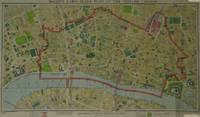
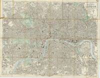
Bacon's Large Scale Plan of the City of London. ...Completely revised up-to-date. Price 4/- cloth.
by BACON, G.W., & Co. Ltd.
- Used
- Condition
- Used
- Quantity Available
- 1
- Seller
-
London, London, United Kingdom
- Item Price
-
A$484.55A$17.35 shipping to USA
Show Details
Description:
London: G. W. Bacon & Co. Ltd., 30 Museum Street [1948]. Map dimensions 38 x 67 cm, overall dimensions 42 x 71 cm. Folding plan of the City, on a scale of 12 inches to the mile. The plan shows the extents from Farringdon down to Southwark and Aldgate across to Aldwych. The whole backed on linen, folding into original brown printed card wrapper with Underground map printed on verso, 16 pp. Index booklet to inner cover A fine copy. A serial number y/8 appears next to the copyright at the bottom left margin, presumably 1948. Certainly a post war issue as it highlights "Blitzed City Areas" (Cf. Boyle, 445.)
Item Price
A$484.55
A$17.35
shipping to USA
Bacon's Large Scale Plan of the City of London. ...Completely revised up-to-date. Price 4/- cloth.
by BACON, G.W., & Co. Ltd.
- Used
- Condition
- Used
- Quantity Available
- 1
- Seller
-
London, London, United Kingdom
- Item Price
-
A$484.55A$17.35 shipping to USA
Show Details
Description:
London: G. W. Bacon & Co. Ltd., 30 Museum Street [1948]. Map dimensions 38 x 67 cm, overall dimensions 42 x 71 cm. Folding plan of the City, on a scale of 12 inches to the mile. The plan shows the extents from Farringdon down to Southwark and Aldgate across to Aldwych. The whole backed on linen, folding into original brown printed card wrapper with Underground map printed on verso, 16 pp. Index booklet to inner cover A serial number y/8 appears next to the copyright at the bottom left margin, presumably 1948. Certainly a post war issue as it highlights "Blitzed City Areas" (Cf. Boyle, 445.)
Item Price
A$484.55
A$17.35
shipping to USA

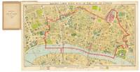
Bacon's Large Scale Plan of Willesden Including Harlesden, Neasden and Shepherd's Bush. [Cover Title]
by BACON, G.W., & Co. Ltd.
- Used
- Condition
- Used
- Quantity Available
- 1
- Seller
-
London, London, United Kingdom
- Item Price
-
A$290.73A$17.35 shipping to USA
Show Details
Description:
London: G.W. Bacon & Co. Ltd. 127 Strand.[N.D. but c. 1913]. Map dimensions 47 x 59.5 cm, overall dimensions 49 x 63 cm. Colour printed plan of this area of North West London, showing the extents from Brent Reservoir down to Acton and Paddington across to Ealing Broadway. The plan folds between original printed blue/grey paper covers. Ownership inscription of a P.W. Barrett to upper cover. Very minor tear to spine of covers, otherwise in very good condition overall. British Library, Maps 3465.(12.), their example with an attributed date of 1913. The Central Line extension from Wood Lane to Ealing Broadway via East and North Acton stations is (neatly) drawn on the map in manuscript. This section of the line was opened in August, 1920. The plan includes Hampstead and Notting Hill.
Item Price
A$290.73
A$17.35
shipping to USA

Bacon's Large-Print Map of the Transvaal, Orange Free State, Cape Colony, Natal, &c. With Large-Scale Inset Maps. Twelfth Edition.
by BACON, G.W.
- Used
- Condition
- Used
- Quantity Available
- 1
- Seller
-
London, London, United Kingdom
- Item Price
-
A$193.82A$17.35 shipping to USA
Show Details
Description:
London: G.W. Bacon & Co., Ltd., 127, Strand. January, 1900.. Original colour-printed map of South Africa (56 x 76 cm) folding between original orange card covers printed in black with pp.11 pamphlet entitled "The War in South Africa" affixed to front pastedown. Ex libris Massachusetts State Library with their blind stamp to upper cover and pamphlet. Neat professional repairs to folds etc, A bright copy.
Item Price
A$193.82
A$17.35
shipping to USA
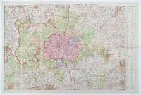
Bacon's Library Map of the Environs of London.
by BACON, G.W., & Co. Ltd.
- Used
- Hardcover
- Condition
- Used
- Binding
- Hardcover
- Quantity Available
- 1
- Seller
-
London, London, United Kingdom
- Item Price
-
A$484.55A$17.35 shipping to USA
Show Details
Description:
London: G. W. Bacon & Co. Ltd. Norwich Street, Fetter Lane, EC4. [c. 1931]. Map dimensions 92 x 132 cm (excluding table to right margin), overall dimensions 100 x 149 cm. Large folding map of London and the surrounding regions covering the extents from Hoddesdon down to Reigate and Canvey Island across to Windsor. Bright original colour marking out the counties, boroughs, districts and parishes. The map divided into three mile squares numbered and lettered at the borders, the grid references corresponding to a large index of local authorities found at the right margin. Printed over four conjoined sheets, the whole divided into 28 sections and mounted on linen. Folds into orginal dark green cloth slipcase, gilt lettered to the upper board. Marbled paper to folded end sections on linen verso. The slipcase slightly worn at extremities, one of the lower joints cracked at the upper edge. The map in excellent condition. The Northern Line extension from Clapham Common to Morden (opened 1926) is marked on…
Read More Item Price
A$484.55
A$17.35
shipping to USA

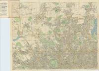
Bacon's New Chart of the World.
by BACON, G[eorge] W[ashington].
- Used
- Hardcover
- Condition
- Used
- Binding
- Hardcover
- Quantity Available
- 1
- Seller
-
London, London, United Kingdom
- Item Price
-
A$1,453.65A$17.35 shipping to USA
Show Details
Description:
Manchester: G.W. Bacon & Co. Ltd, Royal London Buildings, Deansgate, [c.1906].. Original large colour-printed chart of the world on Mercator's projection (c. 96 x 120 cm overall), dissected into 24 sections and mounted onto linen, the territories of the British Empire marked in pink/red. Folding between publisher's original burgundy cloth covers (25 x 21 cm) with title in gilt to upper cover, marbled endpapers. A notably clean copy, excellent in the original publisher's cloth. A wealth of detail is recorded on the chart, both in the mapped areas and to the inset panels: - 46 flag illustrations to the upper edge - 18 maps of mostly port cities scattered across the chart including New York, San Francisco, Wellington, Tokyo, Singapore, Hong Kong and Bombay - a larger inset map of the British Isles to the lower margin - polar hemisphere maps to the upper corners - panels of text to the lower margin including a list of British Steamship routes, a gazetteer of towns and a list of territories in the…
Read More Item Price
A$1,453.65
A$17.35
shipping to USA
Bacon's New Large-Scale Map of North London and Suburbs.
by BACON, G.W.
- Used
- Hardcover
- Condition
- Used
- Binding
- Hardcover
- Quantity Available
- 1
- Seller
-
London, London, United Kingdom
- Item Price
-
A$387.64A$17.35 shipping to USA
Show Details
Description:
London: G.W. Bacon & Co., Ltd., 127, Strand, [1904].. Original hand-coloured folding map of north London (72 x 92 cm), scale of four inches to a mile, extending north to Palmer's Green, east to Tottenham Hale, south to Euston, and west to the Hyde, folding between original red cloth covers printed in black. Roads coloured to show bus and tram routes, electric railways shaded in green. With illustrated guide (pp.34) which includes adverts, tables and small maps. Part of the guide disbound but present, map generally in excellent condition.
Item Price
A$387.64
A$17.35
shipping to USA
Bacon's New Map of London, Divided Into Half Mile Squares & Circles. Scale Four Inches to the Mile. Title on upper cover: Bacon's New Shilling Map of London and Illustrated Guide.
by BACON, G.W.
- Used
- Hardcover
- Condition
- Used
- Binding
- Hardcover
- Quantity Available
- 1
- Seller
-
London, London, United Kingdom
- Item Price
-
A$581.46A$17.35 shipping to USA
Show Details
Description:
London: G.W. Bacon & Co. 127, Strand, [c.1878].. Original hand coloured folding map of London (65 x 82 cm), showing extents from Highbury in the north to Hackney in the east, Kennington in the south, and Holland Park in the west, printed on paper and folding between original publisher's brown cloth boards with label to upper cover, advertisements for 'Chas. Baker & Co.' to inside of upper cover, and for the Ammoniaphone and Electropathic Battery Belt to verso of map and back cover. Minor discolouration along some folds, neat tape reinforcements to verso, scattered spotting most noticeably to upper left panel. Hyde, 160 (2).
Item Price
A$581.46
A$17.35
shipping to USA

Bacon's New Large-Scale Map of South London and Suburbs. With Index.
by BACON, G.W.
- Used
- Hardcover
- Condition
- Used
- Binding
- Hardcover
- Quantity Available
- 1
- Seller
-
London, London, United Kingdom
- Item Price
-
A$387.64A$17.35 shipping to USA
Show Details
Description:
London: G.W. Bacon & Co. [1904].. Original hand-coloured map of south London (80 x 101 cm) mounted onto linen and folding between publisher's original blue cloth covers with gilt lettering. With a 35 page index which includes a double-page map of central London, advertisements, and a list of places of interest. Extending from Hyde Park in the north to Thornton Heath in the south, Fulham in the west and the Isle of Dogs in the east. Some light toning and soiling, generally a very good copy.
Item Price
A$387.64
A$17.35
shipping to USA
Bacon's New Map of London, Divided into half mile squares & circles. Scale Four Inches to the Mile. [Title on upper cover: Bacon's New Map of London and Illustrated Guide.]
by BACON, [George Washington.]
- Used
- Hardcover
- Condition
- Used
- Binding
- Hardcover
- Quantity Available
- 1
- Seller
-
London, London, United Kingdom
- Item Price
-
A$581.46A$17.35 shipping to USA
Show Details
Description:
London: G.W. Bacon & Co. 127 Strand. [c.1876]. (66 x 84 cm). Original hand coloured folding map of London, showing extents from Highbury in the north to Kennington in the south and from Holland Park in the west to Hackney in the east. The map is printed on paper, mounted on linen and folds between original publisher's red cloth boards, with titles and decoration stamped in gilt and black to upper cover and blind to lower cover. Advertisement for 'Chas. Baker & Co.' to inside of upper cover and Guide Book and Index Slight wear to some fold corners. Hyde, 160 (1).
Item Price
A$581.46
A$17.35
shipping to USA

Didn’t find what you’re looking for?
Try adding this search to your want list. Millions of books are added to our site everyday and when we find one that matches your search, we’ll send you an email. Best of all, it’s free.
Add to Want List

Are you a frequent reader or book collector?
Join the Bibliophile's Club and save 10% on every purchase, every day — up to $20 savings per order!

Social Responsibility
Did you know that since 2004, Biblio has used its profits to build 16 public libraries in rural villages of South America?
