Description:
Espanola, Ontario: LD21, (1943). First edition.. Original blue cloth stamped in blind on front cover. Illustrated title page. Printed on pink paper. A very good copy. 90 leaves printed on rectos only. All text in German. A very scarce book of wartime cartoons, created and published by German prisoners at the Canadian POW camp (Camp 21) at Espanola, Ontario (near Sudbury).
Search Results: Titles starting with K from William Matthews, Bookseller / The Haunted Bookshop
You searched for:
- Bookseller inventory: William Matthews, Bookseller / The Haunted Bookshop (titles starting with K)
- Bookseller: William Matthews, Bookseller / The Haunted Bookshop
Results 1 - 20 of 64

More Photos
K.G. Humor. 85 Zeichnungen von Robert Hopf - mit Text von Heinz Clauss.
by Hopf (Robert) (text by Heinz Clauss)
- Used
- Hardcover
- Condition
- Used
- Binding
- Hardcover
- Quantity Available
- 1
- Seller
-
Sidney, British Columbia, Canada
- Item Price
-
A$342.74A$27.42 shipping to USA
Show Details
Item Price
A$342.74
A$27.42
shipping to USA

Kahawa.
by Westlake (Donald E.)
- Used
- Condition
- Used
- Quantity Available
- 1
- Seller
-
Sidney, British Columbia, Canada
- Item Price
-
A$53.32A$27.42 shipping to USA
Show Details
Description:
cat40a. NY: Warner/Mysterious Press, (1997). First Warner edition, advance reading copy, uncorrected. Pictorial wrappers. Some light wear to fore-edge, one corner scuffed, but a fine copy. Folded promotional leaf laid in. The Africa Novel. Originally published in 1982.
Item Price
A$53.32
A$27.42
shipping to USA
![Kaiserlicher Audienz Saal Aus dem Neuhof. [Supreme Imperial Hall of Audience, after Nieuhof].](https://d3525k1ryd2155.cloudfront.net/h/024/155/1357155024.0.m.jpg)
Kaiserlicher Audienz Saal Aus dem Neuhof. [Supreme Imperial Hall of Audience, after Nieuhof].
by Bellin (Jacques-Nicolas) or Cochin (Charles Nicolas) - possible artist. Engraved by Frans de Bakker. (Published by: Johann Joachim Schwabe)
- Used
- Condition
- Used
- Quantity Available
- 1
- Seller
-
Sidney, British Columbia, Canada
- Item Price
-
A$114.25A$27.42 shipping to USA
Show Details
Description:
Leipzig: Arkstee und Merkus, 1749.. A copper engraved view on laid paper, uncoloured, from Volume 5 of Schwabe's Allgemeine Historie der Reisen (1747 - 1774). Image size is 25cm x 17cm. Text in German. Verso blank. At upper right: "No. 43.". At lower right: "F. de Bakker fecit, 1749." and "T.V.F.". Original vertical folds, clean, very nice condition. This view, possibly by Bellin, engraved by de Bakker, appeared earlier in Prevost's Histoire Generale des Voyages. An image of the Imperial Audience Hall at Beijing, China. The scrollwork cartouche contains a numbered key to locations in the image. This image is based on the one by Jean Nieuhof, published in his 1665 work: L'Ambassade de la Compagnie Orientale des Provinces Unies vers L'Empereur de la Chine .... ("Le dedans du Palais Imperial 'T KEYSERS HOF van binnen" - pg. 215).
Item Price
A$114.25
A$27.42
shipping to USA
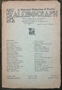
Kaleidograph. A National Magazine of Poetry.
by Smith (Clark Ashton) -contributor.
- Used
- Condition
- Used
- Quantity Available
- 1
- Seller
-
Sidney, British Columbia, Canada
- Item Price
-
A$68.55A$27.42 shipping to USA
Show Details
Description:
cat40a. Dallas, Texas: Kaleidograph Press, 1942. Volume XIII, Number 9. January, 1942. Original printed wrappers, stapled. 28 pages. A bit of chipping to edges, very good condition. A prize entry blank at the rear is still present. Clark Ashton Smith contributes a poem occupying 3/4 of a page: Madrigal Of Memory.
Item Price
A$68.55
A$27.42
shipping to USA
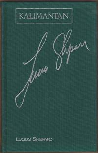
Kalimantan. Illustrated by Jamel Akib.
by Shepard (Lucius)
- Used
- Hardcover
- Condition
- Used
- Binding
- Hardcover
- Quantity Available
- 1
- Seller
-
Sidney, British Columbia, Canada
- Item Price
-
A$76.16A$27.42 shipping to USA
Show Details
Description:
cat40a. London: Century / Legend, (1990). First edition. Green cloth, lettered in silver. Marbled end papers. A fine copy in a clear glasine jacket, in a matching slipcase, also lettered in silver. This is copy 51 of 300 numbered & signed copies. In Borneo, a psychoactive drug gives access to another dimension.
Item Price
A$76.16
A$27.42
shipping to USA
More Photos
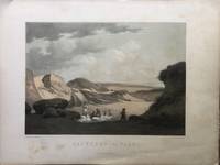
Kalkbrud ved Faxo.
by Denmark - Lime Quarrying.
- Used
- Condition
- Used
- Quantity Available
- 1
- Seller
-
Sidney, British Columbia, Canada
- Item Price
-
A$114.25A$27.42 shipping to USA
Show Details
Description:
Copenhagen: Baerentzen & Co, [1856]. . A coloured lithograph by A. Nay from a drawing by A. Juuel. Sheet size is 38cm x 29cm. A scene of lime quarrying in the South Zealand region of Denmark, near Faxo (Faxe, Fakse). Some foxing to margins, a clean very good copy. From the portfolio DANMARK published by Emilius Baerentzen, 1856.
Item Price
A$114.25
A$27.42
shipping to USA
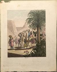
Karavanen in der Sahara.
by Schaffer (Daniel) [Copper Engravings by Schüppel, Meno Haas, Peter Haas and G.A. Lehmann; art by Johann Niedlich, others.]
- Used
- Condition
- Used
- Quantity Available
- 1
- Seller
-
Sidney, British Columbia, Canada
- Item Price
-
A$68.55A$27.42 shipping to USA
Show Details
Description:
Berlin, 1803.. A copper engraved view on wove paper, coloured, from Volume 2 (Plate V) of Daniel Schaffer's 1803 work: Der Weltumsegler. The image size is 4.5 x 5.5 inches, on a sheet measuring 6.5 x 8 inches. Condition is very good, small chip to upper margin. At the lower right is printed: "M Haas". At lower left is: "Nidlich del.". The image depicts a caravan of camels & people in the Sahara.
Item Price
A$68.55
A$27.42
shipping to USA
More Photos
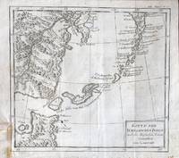
Karte Der Kurillischen Inseln nach der Russischen Karte Gezeichnet von Laurent.
by Bellin (Jacques-Nicolas) [Nicolaus] (Published by: Johann Joachim Schwabe)
- Used
- Condition
- Used
- Quantity Available
- 1
- Seller
-
Sidney, British Columbia, Canada
- Item Price
-
A$114.25A$27.42 shipping to USA
Show Details
Description:
Leipzig: Arkstee und Merkus, c.1771. A copper engraved map on laid paper, uncoloured, from Volume 20 of Schwabe's Allgemeine Historie der Reisen (1748 - 1774). Image size is 26cm x 24cm. Text in German. Verso blank. In upper right corner: "XX. Band No. 15.". Original folds, very good condition, yellow tape or glue mark at lower left, on verso, light foxing to margins. A map of the Kuril Islands, from Bellin's French map (Carte des Iles Kouriles....) published in Prevost's L'Histoire Generale des Voyages (Volume 19, 1770). The contentious Kuril Islands lie between Japan and Russia, claimed by Russia after World War 2.
Item Price
A$114.25
A$27.42
shipping to USA
Karte Von Sibirien und den benachbarten Laendern .... von dem Hrn Bellin.
by Bellin (Jacques Nicholas)
- Used
- Condition
- Used
- Quantity Available
- 1
- Seller
-
Sidney, British Columbia, Canada
- Item Price
-
A$152.33A$27.42 shipping to USA
Show Details
Description:
[Leipzig, 1769]. . A copper engraved map on laid paper, uncoloured. At lower right: "T.XIX.M.". At upper right: No.4. Image size is 18 x 11.5 inches. From Volume 19 of the German edition of Prevost's large work: Histoire Générale des Voyages [German title: Allgemeine Historie der Reisen zu Wasser und Lande.... Leipzig : Bey Arkstee und Merkus, 1747-1774.]. The French edition of this map ("Carte de la Siberie Et des Pays Voisins") was published in Volume 18 of the French edition of Prevost (1763).
Item Price
A$152.33
A$27.42
shipping to USA
More Photos
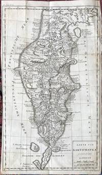
Karte Von Kamtschatka gezeichnet von Laurent.
by Bellin (Jacques Nicholas)
- Used
- Condition
- Used
- Quantity Available
- 1
- Seller
-
Sidney, British Columbia, Canada
- Item Price
-
A$228.50A$27.42 shipping to USA
Show Details
Description:
[Leipzig, c.1771]. . A copper engraved map on laid paper, uncoloured. Imprint at lower right: P. Mol Sculps. 1771. Volume indicated at upper left: XX.Band.No. 8. Image size is 29.5cm x 49cm, small margins, trimmed right up to the plate line along part of the left edge. Two small paper tape repairs to folds at verso, some offsetting from adjacent text to verso, original horizontal folds, scattered light foxing, an attractive copy. From Volume 20 of a German edition of Prevost's large work: Histoire Générale des Voyages [German title: Allgemeine Historie der Reisen zu Wasser und Lande.... Leipzig : Bey Arkstee und Merkus, 1747-1774.]. The French edition of this map ("Carte du Kamtchatka") was published [c.1760], in Volume 19 of the French edition of Prevost. A detailed map of the Kamchatka Peninsula, Eastern Russia.
Item Price
A$228.50
A$27.42
shipping to USA

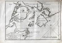
Karte von dem Eylande Teneriffa nach Astronomischen Wahrnehmungen
by Bellin (Jacques-Nicolas) [Nicolaus] (Published by: Johann Joachim Schwabe)
- Used
- Condition
- Used
- Quantity Available
- 1
- Seller
-
Sidney, British Columbia, Canada
- Item Price
-
A$76.16A$27.42 shipping to USA
Show Details
Description:
Leipzig: Arkstee und Merkus, 1748.. A copper engraved map on laid paper, uncoloured, from Volume 2 of Schwabe's Allgemeine Historie der Reisen (1747 - 1774). Image size is 14.5cm x 20.5cm. Text in German. Verso blank. In upper right corner: "No. 2." Clean, very good condition. This map by Bellin first appeared in Prevost's Histoire Generale des Voyages. A map of the Island of Tenerife, the largest of the Canary Islands.
Item Price
A$76.16
A$27.42
shipping to USA
More Photos
Karte von der Westlichen Kuste von Africa von dem XI Grade Suderbreite bis an das Vorgeburge der guten Hoffnung.
by Bellin (Jacques-Nicolas) [Nicolaus] (Published by: Johann Joachim Schwabe)
- Used
- Condition
- Used
- Quantity Available
- 1
- Seller
-
Sidney, British Columbia, Canada
- Item Price
-
A$137.10A$27.42 shipping to USA
Show Details
Description:
Leipzig: Arkstee und Merkus, c.1749. A copper engraved map on laid paper, uncoloured, from Schwabe's Allgemeine Historie der Reisen (1748 - 1774). Image size is 26cm x 24cm. Text in German. Verso blank. Compass rose above cartouche. In upper right corner: "No. 16.". Original folds, very good condition. A map of the Western coast of Africa, from Bellin's map (Coste Occidentale d'Afrique ....) which appeared in Prevost's Histoire Generale des Voyages.
Item Price
A$137.10
A$27.42
shipping to USA
More Photos
Karte von der Bay von Chin-Chew oder Chang-Chew nebst den Eylanden Emowi und Quemowi. Nach verschiedenen Manuscripten entworfen von N.B. Ing. de la Mar.
by Bellin (Jacques-Nicolas) [Nicolaus] (Published by: Johann Joachim Schwabe)
- Used
- Condition
- Used
- Quantity Available
- 1
- Seller
-
Sidney, British Columbia, Canada
- Item Price
-
A$114.25A$27.42 shipping to USA
Show Details
Description:
Leipzig: Arkstee und Merkus, 1749. A copper engraved map on laid paper, uncoloured, from Volume 5 of Schwabe's Allgemeine Historie der Reisen (1748 - 1774). Cartouche in lower left. Image size is 30cm x 21cm. Text in German. Verso blank. In upper right corner: "No. 49". At lower right: "T.V.K." Original folds, very good condition. A map of the Bay of Chin-Chew (Quanzhou), from Bellin's French map (Carte de la Baye de Chin-Chew ou Chang-Chew ....) published in Prevost's L'Histoire Generale des Voyages (Volume 7, 1749).
Item Price
A$114.25
A$27.42
shipping to USA
More Photos
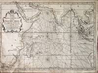
Karte von dem Morgenlaendischen Ocean oder dem Indischen Meere. Zur allgemeinen Historie der Reisebeschreibungen entworfen. Von Hrn. Bellin Ing. de la Marine.
by Bellin (Jacques-Nicolas) [Nicolaus] (Published by: Johann Joachim Schwabe)
- Used
- Condition
- Used
- Quantity Available
- 1
- Seller
-
Sidney, British Columbia, Canada
- Item Price
-
A$190.41A$27.42 shipping to USA
Show Details
Description:
Leipzig: Arkstee und Merkus, 1748.. A copper engraved map on laid paper, uncoloured, from Volume 2 of Schwabe's Allgemeine Historie der Reisen (1748 - 1774). Decorative cartouche in upper left. Image size is 47cm x 34cm. Text in German. Verso blank. In upper right corner: "Zusatz zum 1 Bande 3e Karte.". Original folds, very good condition, old tape repair on verso at lower left. Trimmed to the plate line on the left edge. From Bellin's French map (Carte De L'Ocean Oriental ou Mer Des Indes.... ) published in Prevost's L'Histoire Generale des Voyages (Volume 3, 1747). The German edition of Bellin's map of the Indian Ocean, with the eastern coasts of South Africa, India, Indochina, parts of the East Indies and the Western coast of Australia.
Item Price
A$190.41
A$27.42
shipping to USA
More Photos
Karte von dem Eylande Cheu-Chan oder Chusan in der Provinz Che-kiang, nebst den Kusten und benachbarten Inseln. Aus Thornton u. andern Schiffahrern genommen von N. Bellin Ing. de la Marine.
by Bellin (Jacques-Nicolas) [Nicolaus] (Published by: Johann Joachim Schwabe)
- Used
- Condition
- Used
- Quantity Available
- 1
- Seller
-
Sidney, British Columbia, Canada
- Item Price
-
A$114.25A$27.42 shipping to USA
Show Details
Description:
Leipzig: Arkstee und Merkus, 1750. A copper engraved map on laid paper, uncoloured, from Volume 6 of Schwabe's Allgemeine Historie der Reisen (1748 - 1774). Cartouche in lower left, with compass rose above. Image size is 31.5cm x 20.5cm. Text in German. Verso blank. In upper right corner: "No. 5". Original folds, very good condition. A map of the Zhoushan Islands, from Bellin's French map (Carte de l' Isle de Cheu-Chan ou Isle de Chusan....) published in Prevost's L'Histoire Generale des Voyages (Volume 7,1749 ).
Item Price
A$114.25
A$27.42
shipping to USA
More Photos
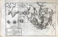
Karte von der Trinquemale-Bay
by Bellin (Jacques-Nicolas) [Nicolaus] (Published by: Johann Joachim Schwabe)
- Used
- Condition
- Used
- Quantity Available
- 1
- Seller
-
Sidney, British Columbia, Canada
- Item Price
-
A$137.10A$27.42 shipping to USA
Show Details
Description:
Leipzig: Arkstee und Merkus, 1764.. A copper engraved map on laid paper, uncoloured, from Volume 18 of Schwabe's Allgemeine Historie der Reisen (1748 - 1774). Image size is 33.5cm x 26cm. Text in German. Verso blank. Sailing ships and compass rose in the Bay. In upper right corner: "No. 7.". In lower left: "Suppl. zum. VIII Bande No. 7". In lower right: T.XVIII 7. Original folds, some scattered foxing mostly to margins, paper tape on verso at a tear in the upper right, very good condition. A map of Trincomalee Bay, also known as Koddiyar Bay, in Sri Lanka.
Item Price
A$137.10
A$27.42
shipping to USA
More Photos
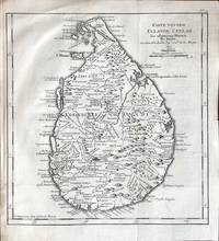
Karte von dem Eylande Ceylan.
by Bellin (Jacques-Nicolas) [Nicolaus] (Published by: Johann Joachim Schwabe)
- Used
- Condition
- Used
- Quantity Available
- 1
- Seller
-
Sidney, British Columbia, Canada
- Item Price
-
A$99.01A$27.42 shipping to USA
Show Details
Description:
Leipzig: Arkstee und Merkus, 1751. A copper engraved map on laid paper, uncoloured, from Volume 8 of Schwabe's Allgemeine Historie der Reisen (1748 - 1774). Image size is 24cm x 25.5cm. Text in German. Verso blank. In upper right corner: "No. 17". Original folds, very good condition, some paper glued to verso at lower left, small old stain to upper right. From Bellin's French map (Carte de L'Isle de Ceylon...) published in Prevost's L'Histoire Generale des Voyages (Volume 8, 1750). The German edition of Bellin's map of Ceylon.
Item Price
A$99.01
A$27.42
shipping to USA
More Photos
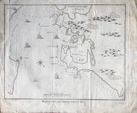
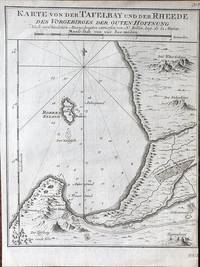
Karte von der Tafelbay und der Rheede des Vorgebirges der Guten Hoffnung.
by Bellin (Jacques-Nicolas) [Nicolaus] (Published by: Johann Joachim Schwabe)
- Used
- Condition
- Used
- Quantity Available
- 1
- Seller
-
Sidney, British Columbia, Canada
- Item Price
-
A$137.10A$27.42 shipping to USA
Show Details
Description:
Leipzig: Arkstee und Merkus, c.1749.. A copper engraved map on laid paper, uncoloured, from Volume 5 of Schwabe's Allgemeine Historie der Reisen (1748 - 1774). Image size is 17cm x 21cm. Text in German. Verso blank. In upper right corner: "No. 7.". At lower right: "T.V.D.". Clean, very good condition. This map by Bellin (French title: Carte De La Baye De La Table et Rade Du Cap De Bonne Esperance) first appeared in 1748 in Volume 5 of Prevost's Histoire Generale des Voyages.... A map of Table Bay, Cape Town, South Africa.
Item Price
A$137.10
A$27.42
shipping to USA

Karte von den Canarischen Eylanden nach den Tagebuchern der Seefahrer.
by Bellin (Jacques-Nicolas) [Nicolaus] (Published by: Johann Joachim Schwabe)
- Used
- Condition
- Used
- Quantity Available
- 1
- Seller
-
Sidney, British Columbia, Canada
- Item Price
-
A$76.16A$27.42 shipping to USA
Show Details
Description:
Leipzig: Arkstee und Merkus, 1748.. A copper engraved map on laid paper, uncoloured, from Volume 2 of Schwabe's Allgemeine Historie der Reisen (1747 - 1774). Image size is 28cm x 20cm. Text in German. Verso blank. In upper right corner: "No. 1." Decorative cartouche at top center. Original folds, very good condition. This map by Bellin first appeared in Prevost's Histoire Generale des Voyages.... A map of the Canary Islands.
Item Price
A$76.16
A$27.42
shipping to USA

Karte von den Eylanden Madera und Porto Santo.
by Bellin (Jacques-Nicolas) [Nicolaus] (Published by: Johann Joachim Schwabe)
- Used
- Condition
- Used
- Quantity Available
- 1
- Seller
-
Sidney, British Columbia, Canada
- Item Price
-
A$76.16A$27.42 shipping to USA
Show Details
Description:
Leipzig: Arkstee und Merkus, 1748.. A copper engraved map on laid paper, uncoloured, from Volume 2 of Schwabe's Allgemeine Historie der Reisen (1747 - 1774). Image size is 22cm x 15.5cm. Text in German. Verso blank. In upper left: "No. 5." Clean, very good condition. This map by Bellin first appeared in Prevost's Histoire Generale des Voyages. A map of the Islands of Madeira and Porto Santo, in Portugal.
Item Price
A$76.16
A$27.42
shipping to USA

Didn’t find what you’re looking for?
Try adding this search to your want list. Millions of books are added to our site everyday and when we find one that matches your search, we’ll send you an email. Best of all, it’s free.
Add to Want List

Are you a frequent reader or book collector?
Join the Bibliophile's Club and save 10% on every purchase, every day — up to $20 savings per order!

Social Responsibility
Did you know that since 2004, Biblio has used its profits to build 16 public libraries in rural villages of South America?
