Description:
Educational Production Produced for William Ridgway & Sons LTD Sheffield. Large Poster measure 76 cms (30 inches) X 50 cms (20 inches) Full colour. In very good condition. Lightly tanned head at bottom edge. Two small marks on right hand margin. Ideal for Work Shop/Shed.
Search Results: Titles starting with O from The Antique Map & Bookshop
You searched for:
- Bookseller inventory: The Antique Map & Bookshop (titles starting with O)
- Bookseller: The Antique Map & Bookshop
Results 1 - 20 of 544

ORIGINAL POSTER. Wood Boring Tools, Auger Bits Hollow Square Chisels & Bits
- Used
- Condition
- Used
- Quantity Available
- 1
- Seller
-
Dorchester, Dorset, United Kingdom
- Item Price
-
A$29.07A$28.98 shipping to USA
Show Details
Item Price
A$29.07
A$28.98
shipping to USA

ORIGINAL POSTER. Marking Out Tools, For Woodwork, Joints
- Used
- Condition
- Used
- Quantity Available
- 1
- Seller
-
Dorchester, Dorset, United Kingdom
- Item Price
-
A$29.07A$28.98 shipping to USA
Show Details
Description:
Educational Productions Limited Produced for William Marples & Sons Ltd. Large Poster measure 76 cms (30 inches) X 51 cms (20 inches) Full colour. In very good condition. Slight tanning to left edge. Ideal for Work Shop/Shed.
Item Price
A$29.07
A$28.98
shipping to USA

ORIGINAL POSTER. Synthetic Resin Adhesives, Aerolite 306, Araldite
- Used
- Condition
- Used
- Quantity Available
- 1
- Seller
-
Dorchester, Dorset, United Kingdom
- Item Price
-
A$29.07A$28.98 shipping to USA
Show Details
Description:
Educational Productions Limited Produced for C.I.B.A. (A.R.L.) Ltd. Large Poster measure 76 cms (30 inches) X 51 cms (20 inches) Full colour. In very good condition. Light tanning to top edge. Small tears to top edge. Ideal for Work Shop/Shed.
Item Price
A$29.07
A$28.98
shipping to USA

ORIGINAL ENGRAVED ANTIQUE MAP OF SURREY
by Hall, Sidney
- Used
- first
- Condition
- Used
- Quantity Available
- 1
- Seller
-
Dorchester, Dorset, United Kingdom
- Item Price
-
A$34.89A$28.98 shipping to USA
Show Details
Description:
Published by Chapman & Hall 1831 1st edition. Uncoloured Unmounted. In very good condition. With a few light folds. Very Clean & strong impression. Engraved surface Size 24 x 19cm
Item Price
A$34.89
A$28.98
shipping to USA

ORIGINAL ENGRAVED ANTIQUE MAP OF SURREY
by Pass, J.
- Used
- Condition
- Used
- Quantity Available
- 1
- Seller
-
Dorchester, Dorset, United Kingdom
- Item Price
-
A$56.21A$28.98 shipping to USA
Show Details
Description:
Published for the Encyclopedia Londinensis 1827. Hand coloured Unmounted. In very good condition. Very Clean & strong impression. Engraved surface Size 24.5 x 20cm
Item Price
A$56.21
A$28.98
shipping to USA

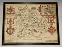
ORIGINAL ENGRAVED MAP OF Oxfordshire. Engraved for LEWIS's “Topographical Dictionary” and drawn by R. Creighton. From: “AN ATLAS comprising Maps of the Several Counties, divided into Unions….”.
by WALKER, J. & C. / LEWIS:
- Used
- Condition
- Used
- Quantity Available
- 1
- Seller
-
Dorchester, Dorset, United Kingdom
- Item Price
-
A$29.07A$28.98 shipping to USA
Show Details
Description:
Published by S.Lewis & Co. Ca 1842.. Overall size: 11 x 8.5 inches In very good condition. A few light marks. Outline Hand Colouring. The Map shows the principal roads, rivers, railways and canals. The Walker brothers were publishers and engravers.
Item Price
A$29.07
A$28.98
shipping to USA

More Photos
ORIGINAL ENGRAVED ANTIQUE MAP OF SURREY Surrey Drawn from an Actual Survey and Regulated by Astronl. Observns. By T. Kitchin Geog.
by T. Kitchin
- Used
- Condition
- Used
- Quantity Available
- 1
- Seller
-
Dorchester, Dorset, United Kingdom
- Item Price
-
A$75.59A$28.98 shipping to USA
Show Details
Description:
Printed for England Illustrated Ca 1763/64. Uncoloured. In very good condition. Very Clean & strong impression. Engraved surface 17.5cm x 20.5cm. The title of the county is contained in an ornamental cartouche.
Item Price
A$75.59
A$28.98
shipping to USA

ORIGINAL POSTER. Pulp Fiction Original 1994 Quad Movie Poster
- Used
- Condition
- Used
- Quantity Available
- 1
- Seller
-
Dorchester, Dorset, United Kingdom
- Item Price
-
A$426.40A$28.98 shipping to USA
Show Details
Description:
United Artist 1994. Large Poster measure 38.5 inches X 27 inches. Full Colour In good condition. Some minor rubbing on edges. Blu-tack on verso of each corner. Small tear lower centre edge. 4 inch faint crack left side edge. Unfolded.
Item Price
A$426.40
A$28.98
shipping to USA

More Photos
AN ORIGINAL ENGRAVED MAP OF Guinea, Africa.
by MERCATOR, G.: HONDIUS, J.:
- Used
- Condition
- Used
- Quantity Available
- 1
- Seller
-
Dorchester, Dorset, United Kingdom
- Item Price
-
A$213.20A$28.98 shipping to USA
Show Details
Description:
J. Hondius, Pieter van den Keere (Petrus Kaerius caelavit) Ca1634. Original engraved map. Unframed. Engraved survace 18.5 x 13.5 cm. (approx 7 x 5.5 ins.) Overall size 22 x 27 cm. (8.5 x 7 ins.) In very good condition. Some overall tanning and darkening. Colouring is a little faded. A couple of minor spots to edges else free of foxing or spots. Good strong impression. An excellent example. With later hand colouring. Mercator's sons and grandsons, were all cartographers and made their contributions in various ways to his atlas. Rumold, in particular, was responsible for the complete edition in 1595. This version has the name "Petrus Kaerius" (Van Den Keere) to bottom right corner, in some editions, this is where the scale "Millaria Germanica" would be.
Item Price
A$213.20
A$28.98
shipping to USA

ORIGINAL ENGRAVED MAP OF BEDFORDSHIRE. Engraved for LEWIS's “Topographical Dictionary” and drawn by R. Creighton. From: “AN ATLAS comprising Maps of the Several Counties, divided into Unions….”.
by WALKER, J. & C. / LEWIS:
- Used
- Condition
- Used
- Quantity Available
- 1
- Seller
-
Dorchester, Dorset, United Kingdom
- Item Price
-
A$32.95A$28.98 shipping to USA
Show Details
Description:
Published by S.Lewis & Co. Ca 1842.. Overall size: 11 x 8.5 inches In good condition. A few light marks in margins. Outline Hand Colouring. The Map shows the principal roads, rivers, railways and canals. The Walker brothers were publishers and engravers.
Item Price
A$32.95
A$28.98
shipping to USA

More Photos
ORIGINAL ENGRAVED ANTIQUE MAP OF CAMBRIDGESHIRE. “A New Map of Cambridgeshire, Drawn from the Latest Authorities.”
by CONDER, T.:
- Used
- Condition
- Used
- Quantity Available
- 1
- Seller
-
Dorchester, Dorset, United Kingdom
- Item Price
-
A$54.27A$28.98 shipping to USA
Show Details
Description:
London, T. Conder Sculpt., Kings Arms, 16. Paternoster Row, ca1700. Original engraved map, Unframed. Engraved surface 19.5 x 16 cm (7.5 x 6 ins). Overall 22 x 17.5 cm (8.5 x 7 ins.) In very good condition. Some minor foxing spots around edges else a very good clean and bright example. The title of the county is contained in an ornamental cartouche, coloured green. With additional remarks, County Crest, and scale in miles.
Item Price
A$54.27
A$28.98
shipping to USA

More Photos
ORIGINAL ENGRAVED MAP OF “BERKSHIRE BERCHERIA Barkshire”.
by BLAEU, JOHN (1596 - 1673):
- Used
- Condition
- Used
- Quantity Available
- 1
- Seller
-
Dorchester, Dorset, United Kingdom
- Item Price
-
A$416.71A$28.98 shipping to USA
Show Details
Description:
1648. Large double sided map (engraved surface 19.5 x 15 inches). Gold tinted black hardwood Frame, with glass front & back. Frame Size 27 x 23.5 inches. Pleasing hand-colouring. An attractive and decorative map with elaborate title-cartouche and coats of arms. There is very light publishers centrefold. Strong impression. Overall in very good condition. Mount a little tanned, and in a wide black Hogarth frame, has some chipping. With DUTCH text on verso. One of the largest and most prolific map publishing houses of the 17th. century. The decorative merit and cartographic excellence of their maps are without doubt
Item Price
A$416.71
A$28.98
shipping to USA

More Photos
ORIGINAL ENGRAVED ANTIQUE MAP OF SURREY
by Seller Grose
- Used
- Condition
- Used
- Quantity Available
- 1
- Seller
-
Dorchester, Dorset, United Kingdom
- Item Price
-
A$60.08A$28.98 shipping to USA
Show Details
Description:
Ca 1809. Attractive later Hand colouring. In very good condition. Very Clean & strong impression. Engraved surface 14.5cm x 12cm. Text below. Page Size 19.5cm x 27cm
Item Price
A$60.08
A$28.98
shipping to USA

ORIGINAL ENGRAVED MAP OF Cheshire. Engraved for LEWIS's “Topographical Dictionary” and drawn by R. Creighton. From: “AN ATLAS comprising Maps of the Several Counties, divided into Unions….”.
by WALKER, J. & C. / LEWIS:
- Used
- Condition
- Used
- Quantity Available
- 1
- Seller
-
Dorchester, Dorset, United Kingdom
- Item Price
-
A$54.27A$28.98 shipping to USA
Show Details
Description:
Published by S.Lewis & Co. Ca 1842.. LARGE MAP. Double Page Map with centre fold. Size of engraved surface: 24 cm x 39 cm. Overall size: ca. 31 cm x 39 cm. In good condition. A few light marks, & a couple of small nicks on edges. Later Hand Colouring. The Map shows the principal roads, rivers, railways and canals. The Walker brothers were publishers and engravers.
Item Price
A$54.27
A$28.98
shipping to USA

ORIGINAL ENGRAVED ANTIQUE MAP OF SURREY
by Slater, I.
- Used
- Condition
- Used
- Quantity Available
- 1
- Seller
-
Dorchester, Dorset, United Kingdom
- Item Price
-
A$85.28A$28.98 shipping to USA
Show Details
Description:
Slater, I. Fleet Street Ca 1840. Hand coloured Unmounted, with Nice vignette top left corner of St. Saviours Church Southwalk In very good condition. Very Clean & strong impression. Engraved surface Size 36 x 23cm
Item Price
A$85.28
A$28.98
shipping to USA

ORIGINAL ENGRAVED ANTIQUE MAP OF SURREY
by Archibald Fullarton, Engraved by R. Scott
- Used
- Condition
- Used
- Quantity Available
- 1
- Seller
-
Dorchester, Dorset, United Kingdom
- Item Price
-
A$42.64A$28.98 shipping to USA
Show Details
Description:
Published by Archibald Fullarton & Co. Ca 1834. Hand coloured Unmounted. In very good condition. A few light foxing marks on margins. Two neat folds. Strong impression. Engraved surface Size 24.5 x 19cm
Item Price
A$42.64
A$28.98
shipping to USA

ORIGINAL ENGRAVED ANTIQUE MAP OF SURREY & SUSSEX on the Reverse. A Modern MAP of SURREY & Sussex, Drawn from the latest Surveys; Corrected & Improved by ye best Authorities. J. Ellis Sculp
by Ellis, John
- Used
- first
- Condition
- Used
- Quantity Available
- 1
- Seller
-
Dorchester, Dorset, United Kingdom
- Item Price
-
A$139.55A$28.98 shipping to USA
Show Details
Description:
Printed for Robt. Sayer in Fleet Street, & Carington Bowles in St. Pauls Church yard. Ca 1766. Uncolouring. In very good condition. Faint mark on one margin edge. Very Clean & strong impression. Engraved surface 19.5cm x 25.5cm. The title of the county is contained in an ornamental cartouche. c.1765 (the first edition was published in 1765 & two further early editions followed in 1766). Although the map is undated the combined sellers imprint of Sayer and Bowles indicates that this is from an early edition of Ellis's English Atlas. There were several later editions which had slightly different sellers imprints with some having maps printed on both sides of the sheet.
Item Price
A$139.55
A$28.98
shipping to USA
More Photos
AN ORIGINAL ENGRAVED MAP OF BREKNOKE (both shire and town) Brecknockshire An attractive and decorative map with inset town plan of Breknoke, scales of English Miles, and 3 elaborate coat of arms. Title cartouche Engraved by Hondius.
by SPEED, JOHN:
- Used
- Condition
- Used
- Quantity Available
- 1
- Seller
-
Dorchester, Dorset, United Kingdom
- Item Price
-
A$629.92A$28.98 shipping to USA
Show Details
Description:
Sudbury & George Humbell 1610-1612. Engraved surface 20 x 15.50 inches. Frame Size 26.5 x 21.50 inches Attractive hand-colouring. A nice example of this decorative County map by John Speed. Includes inset of Breknoke with the coat of arms for James Butler, Earle of Breknoke and three other coasts of arms, plus and early battle scene. FRAMED in Glazed Hogarth Frame. Strong impression with the detail in the engraving clear and black. Frame has a few small chips. Overall in very good condition. Imprint on left- hand corner, giving publishers: “Performed by John Speede. And are to be solde by Sudbury & George Humbell”. The maps by J.Speed are "the best known and most popular of all English county maps" (Tooley). Despite competition from maps of the English counties by Blaeu and Jansson, Speed’ maps were “bestsellers”. A beautifully coloured map of the historic county of Brecknockshire, with an inset map of the city of Brecon.
Item Price
A$629.92
A$28.98
shipping to USA

More Photos
ORIGINAL ENGRAVED ANTIQUE MAP OF SURREY. from Reuben Ramble's Travels Through the Counties of England. Pseudonym of Reverend Samuel Clarke
by Reuben Ramble
- Used
- Condition
- Used
- Quantity Available
- 1
- Seller
-
Dorchester, Dorset, United Kingdom
- Item Price
-
A$213.20A$28.98 shipping to USA
Show Details
Description:
Ca 1844. Nice impression. This map is supplied with the accompanying text which is also very scarce. In very good condition. Engraved surface 16.5cm x 20.5cm Map originally engraved for Miller’s New Miniature Atlas 1810. Republished in 1845 by Ramble, he added lithographed illustrations around the map featuring topographical and genre representations of the County - scarce.
Item Price
A$213.20
A$28.98
shipping to USA

More Photos
ORIGINAL ENGRAVED MAP OF WESTMORELAND. From “The English Counties Delineated”. Or, A Topographical Description of England.
by MOULE, THOMAS:
- Used
- Condition
- Used
- Quantity Available
- 1
- Seller
-
Dorchester, Dorset, United Kingdom
- Item Price
-
A$63.96A$28.98 shipping to USA
Show Details
Description:
1837.. Engraved surface: 10 x 8 ins. In ivory mount with gilt line 14 x 12 ins. T. Moule (1754 - 1851), an authority on heraldry, embellished his maps with amorials and other features. His was the last series of British Maps to follow the tradition of decorative armorial cartography and they make a pleasing and attractive addition to any home. Nice later hand colouring. Attractive map.
Item Price
A$63.96
A$28.98
shipping to USA

Didn’t find what you’re looking for?
Try adding this search to your want list. Millions of books are added to our site everyday and when we find one that matches your search, we’ll send you an email. Best of all, it’s free.
Add to Want List

Are you a frequent reader or book collector?
Join the Bibliophile's Club and save 10% on every purchase, every day — up to $20 savings per order!

Social Responsibility
Did you know that since 2004, Biblio has used its profits to build 16 public libraries in rural villages of South America?
