Description:
1854. Hardcover. Good. Lithograph map with original hand-colored highlights. Approximately 12 1/4 X 12 1/2" on 18 X 18" sheet with extensive printed text at all margins. Title and credit in the map at upper right, good condition with some aging at folds. <br> Original slim 12mo dark green leather-covered board folder with gilt lettering at upper cover. Some scuffing and wear at edges. Additional smaller lithograph map with hand-colored highlights mounted at inside of upper cover. Lengthy 1858 pencil notation of purchase ("on the Field of Waterloo") from Cotton's niece on verso of map.
Arctic Regions showing The North-West Passage; as determined by Cap. R. McClure and other Arctic Voyagers. Compiled by J. Hugh Johnson, F.R.G.S. [The Royal Illustrated Atlas of Modern Geography with an Introductory notice by Dr. N. Shaw, Secretary to the Royal Geographical Society, Plate III.] by Fullarton, A. and J. Hugh Johnson - 1872
by Fullarton, A. and J. Hugh Johnson
![Arctic Regions showing The North-West Passage; as determined by Cap. R. McClure and other Arctic Voyagers. Compiled by J. Hugh Johnson, F.R.G.S. [The Royal Illustrated Atlas of Modern Geography with an Introductory notice by Dr. N. Shaw, Secretary to the Royal Geographical Society, Plate III.] by Fullarton, A. and J. Hugh Johnson - 1872](https://d3525k1ryd2155.cloudfront.net/h/432/883/1497883432.0.m.jpg)
Arctic Regions showing The North-West Passage; as determined by Cap. R. McClure and other Arctic Voyagers. Compiled by J. Hugh Johnson, F.R.G.S. [The Royal Illustrated Atlas of Modern Geography with an Introductory notice by Dr. N. Shaw, Secretary to the Royal Geographical Society, Plate III.]
by Fullarton, A. and J. Hugh Johnson
- Used
- very good
London: A. Fullarton and Company, 1872. Later Edition. Very Good. [Map dated 1856][18.5x12.5 sheet, no sheet neatline]; Two colored maps - Arctic polar projection to 60 North [9.75in dia.] and detailed inset of Wellington Channel with Melville Island and others [4x9.25in, 74 to 78 N, 90 to 125 W] bordered by eleven colored vignettes from different Arctic journals and expeditions, relief shown by hachures, details ocean currents and direction, route of Northwest passage, geographical names, tundra line, forts and settlements; Some age toning to all edges, bottom edge trimmed with loss of publisher text, small stain bleed from verso at Kolyma river text and upper right vignette, light toning to maps and illustrations, darker colors that on other maps. [Rumsey 3007-003] CS. Archibald Fullarton (1804-1882) was a Glasgow publisher in partnership with John Blackie from 1809. He published several "Royal Illustrated Atlas" editions starting in 1864. This 1856 map was included in the 1872 edition as Plate 111 of the Atlas. Many of the maps were noted for the detailed illustrations and coloring. Also, many of the maps, according to Rumsey, were not updated in the various editions, as typical of other multiple issues of Atlases. This map still shows Alaska as Russian America, which was bought by the United States in 1867.
The eleven vignettes form an illustrated "border" for the two maps. The illustrations are from various sources to wonderfully show the beauty and harshness of the Arctic, the people and animals. The top vignette is the H.M.S. Prince Albert" surrounded by ice bergs in Melville Bay, and watched by seals and birds. Others are, Cape Cape Hotham with the "H.M.S. Pioneer and Resolute", an Esquimaux female, man and boy, seal hunting scene, building a snow hut (from Kennedy's 2nd voyage of the Prince Albert), sledge traveling from Osborne's Arctic Journal, walrus or horse on an ice flow, the "H.M.S. Terror" thrown up by the ice in Prosen Strait, and a polar bear and otter on the ice.
Robert McClure (1807-1873) was a British Royal Navy Captain and Arctic explorer. In 1850, McClure was ordered to command the "H.M.S. Investigator" and explore the North-West passage from the west through the Bering Strait. They were successful in pushing through the coastal ice flows to discover Bank Is and the strait to the Melville Sound, which confirmed the Northwest passage route to the Atlantic ocean.
This map was from the library of the late Dr. G. Warren Smith of Pennsylvania. He had a long career as university professor and administrator, and was a collector of over 6,000 books, maps, illustrations, and artifacts relating to the Arctic, Alaska and Pacific Northwest.
-
Bookseller
David Spilman Fine Books, ABAA & IOBA
 (US)
(US)
- Book Condition Used - Very Good
- Quantity Available 1
- Edition Later Edition
- Publisher A. Fullarton and Company
- Place of Publication London
- Date Published 1872
- Keywords GETMAN0324

More Photos
Plan of the Battle of Waterloo
by Edward Cotton
- Used
- good
- Hardcover
- Condition
- Used - Good
- Binding
- Hardcover
- Quantity Available
- 1
- Seller
-
Boonsboro, Maryland, United States
- Item Price
-
A$491.06
Show Details
Item Price
A$491.06
![Alaska and Klondike Region; [With inset of Klondike Region on the Upper Yukon detail] [From an...](https://d3525k1ryd2155.cloudfront.net/h/062/537/1339537062.0.m.jpg)
Alaska and Klondike Region; [With inset of Klondike Region on the Upper Yukon detail] [From an atlas, "Gazetteer of Alaska and Yukon Region " pp. 105 and 106]
by Miller, J. Martin
- Used
- very good
- Condition
- Used - Very Good
- Edition
- Unknown
- Binding
- Unknown
- Quantity Available
- 1
- Seller
-
Sebastopol, California, United States
- Item Price
-
A$60.13
Show Details
Description:
Chicago: J. Martin Miller, 1899. Unknown. Map. Very Good. [Map copyright 1899, printing date of Atlas later] [19.875x15.125in]; Colored map of Alaska with steamer routes from Portland and Seattle, insets of the Klondike Region on the Upper Yukon and Western portion of Aleutian Islands; On verso index of places and names with two large black and white images; Age toning to all edges, water stain marks on bottom, slight printing offset of colors, small chips and closed tears to lower edge;.
Item Price
A$60.13
More Photos
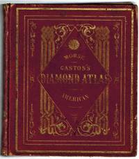
The Diamond Atlas. With Descriptions of all Countries: Exhibiting Their Actual and Comparative Extent, and Their Present Political Divisions, Founded on the Most Recent Discoveries and Rectifications. The Western Hemisphere
by Colby, Charles
- Used
- very good
- Hardcover
- first
- Condition
- Used - Very Good
- Jacket Condition
- No Jacket, As Issued
- Edition
- First Edition
- Binding
- Hardcover
- Quantity Available
- 1
- Seller
-
Bloomington, Indiana, United States
- Item Price
-
A$462.54
Show Details
Description:
New York: Samuel N. Gaston, 1857. In publisher's red morocco ornately embossed in gilt, all edges gilt, with 55 hand water colored maps including maps of all the states as of 1850 and rare maps of the Western Territories, as well as maps of Canada, Mexico, Central and South America. Very Good, the end papers darkened, illegible prior owner name in pencil front end page dated Sept. 2nd, 1857, Troy, Miami Co., Ohio, a handful of pages loose from binding, rubbing at edges and corners, joints and hinges sound. . First Edition. Embossed Cloth. Very Good/No Jacket, As Issued. 12mo - over 6¾" - 7¾" tall.
Item Price
A$462.54

More Photos
1932 Map of Long Beach - Lyon Van and Storage Co.
by Noordwall & Son Mapmakers of Los Angeles
- Used
- Fine
- Paperback
- Condition
- Used - Fine
- Binding
- Paperback
- Quantity Available
- 1
- Seller
-
Bloomington, Indiana, United States
- Item Price
-
A$385.45
Show Details
Description:
Los Angeles: Neuner Printing & Lithograph Co., 1932. SCARCE. Map of Long Beach, California printed by Neuner Printing, Los Angeles and done by Noordwall & Son Mapmakers of Los Angeles for Lyon Van & Storage Co. Folded size 7" x 3 3/4", opens to 21 3/4" x 14". With photos of Lyon Van's operations and procedures both sides. Fine, red dot marked on map presumably locating the new address where customers were being moved.. Folded Map . Fine. 7" x 3 3/4" .
Item Price
A$385.45
![Northern Regions; [Published in Colton's General Atlas, 1861 as No. XII]](https://d3525k1ryd2155.cloudfront.net/h/569/126/1453126569.0.m.jpg)
Northern Regions; [Published in Colton's General Atlas, 1861 as No. XII]
by Colton, George
- Used
- very good
- first
- Condition
- Used - Very Good
- Edition
- First State, Later Printing
- Binding
- Unknown
- Quantity Available
- 1
- Seller
-
Sebastopol, California, United States
- Item Price
-
A$259.02
Show Details
Description:
New York: J. H. Colton & Co, 1855. First State, Later Printing. Very Good. [14x11in Neatline, 17.5x14.25in Sheet]; Map with distinctive Colton borders of discovered Arctic features land features; Some age-toning and light stains along edges [Rumsey Collection 2441.008]. The Northern Regions map was initially drawn and engraved for publication in Colton's General Atlas of 1855. Colton reissued atlases in different formats, pagination, collation and map updates over the years. This map was from the 1861 issue and distinctive in the roman numerals format and number placement. The map has not been altered since 1855. The map does not show still to be discovered Wrangel Is.( late 1860's), Franz Joseph land (1873) , or the northern Greenland coast line (Late 1890's). The map shows the future Alaska as "Russian Possessions" (acquired by the United States in 1868). The map also noted the "Open Polar Sea", one of the many theories yet to be discovered and corrected about the Arctic.
Item Price
A$259.02

More Photos
Arab navigation in the Indian Ocean before the coming of the Portuguese
by Ahmad ibn Majid al-Sadi , G.R. Tibbetts
- Used
- Hardcover
- first
- Condition
- Very Good: Cover some light shelf wear, inside as new
- Edition
- First Edition
- Binding
- Hardcover
- ISBN 10 / ISBN 13
- 9780718909000 / 0718909003
- Quantity Available
- 1
- Seller
-
Berg en dal, Netherlands
- Item Price
-
A$396.67
Show Details
Description:
Ahmad ibn Majid al-Sadi, G.R. Tibbetts - Arab Navigation in the Indian Ocean before the coming of the Portuguese - London, The Royal Asiatic Society of Great Britain and Ireland; Luzac and Company Ltd, 1971 - First Edition - Hardcover - 614pp + 4 maps (out of 7)- 22x14 cmCondition Very Good: Cover some light shelf wear, inside as new. Four out of seven maps present: Chart of the Arabian Sea, India and the Bay of Bengal, Red Sea and Gulf of Eden, East African CoastIf you have any questions or want to see more pictures, feel free to ask.Your book will be securely packed and shipped with tracking number, signed & insured.
Item Price
A$396.67
Alaska and Klondike Region; [With inset of Klondike Region on the Upper Yukon detail] [From an atlas, "Gazetteer of Alaska and Yukon Region " pp. 105 and 106]
by Miller, J. Martin
- Used
- very good
- Condition
- Used - Very Good
- Edition
- Unknown
- Binding
- Unknown
- Quantity Available
- 1
- Seller
-
Sebastopol, California, United States
- Item Price
-
A$60.13
Show Details
Description:
Chicago: J. Martin Miller, 1899. Unknown. Map. Very Good. [Map copyright 1899, printing date of Atlas later] [19.875x15.125in]; Colored map of Alaska with steamer routes from Portland and Seattle, insets of the Klondike Region on the Upper Yukon and Western portion of Aleutian Islands; On verso index of places and names with two large black and white images; Age toning to all edges, water stain marks on bottom, slight printing offset of colors, small chips and closed tears to lower edge;.
Item Price
A$60.13

More Photos
1875 ILLINOIS CENTRAL MAP.: Map of the Illinois Central Railroad and its Connections.
- Used
- Condition
- Used
- Quantity Available
- 1
- Seller
-
Houston, Texas, United States
- Item Price
-
A$454.83
Show Details
Description:
[Railroad] Map of the Illinois Central Railroad and its Connections. Chicago: Rand McNally and Company Map Engravers. 1875. Map printed on green paper. 33 x 25 on sheet 40 x 38 cm folded to 9 x 19 cm. Added text printed in green in margins around map. One three inch fold split, else very good.OCLC shows one holding (Newberry Lib.) Relief shown by hachures. Timetables on verso "corrected to June 20th, 1875." Text describing routes and connections on 5 panels on verso: Illinois Central Railroad principal connections -- Illinois Central Railroad Dubuque and Sioux City Line! -- Illinois Central Railroad, the direct route from Chicago to Springfield, Farmer City, Clinton and Mt. Pulaski -- Illinois Central Railroad St. Louis through line -- Illinois Central Railroad New Orleans through line.
Item Price
A$454.83
Northern Regions; [Published in Colton's General Atlas, 1861 as No. XII]
by Colton, George
- Used
- very good
- first
- Condition
- Used - Very Good
- Edition
- First State, Later Printing
- Binding
- Unknown
- Quantity Available
- 1
- Seller
-
Sebastopol, California, United States
- Item Price
-
A$259.02
Show Details
Description:
New York: J. H. Colton & Co, 1855. First State, Later Printing. Very Good. [14x11in Neatline, 17.5x14.25in Sheet]; Map with distinctive Colton borders of discovered Arctic features land features; Some age-toning and light stains along edges [Rumsey Collection 2441.008]. The Northern Regions map was initially drawn and engraved for publication in Colton's General Atlas of 1855. Colton reissued atlases in different formats, pagination, collation and map updates over the years. This map was from the 1861 issue and distinctive in the roman numerals format and number placement. The map has not been altered since 1855. The map does not show still to be discovered Wrangel Is.( late 1860's), Franz Joseph land (1873) , or the northern Greenland coast line (Late 1890's). The map shows the future Alaska as "Russian Possessions" (acquired by the United States in 1868). The map also noted the "Open Polar Sea", one of the many theories yet to be discovered and corrected about the Arctic.
Item Price
A$259.02
![Upper Mines Nos. 1 & 8 [and] Lower Mines No. 3 or Mormon Diggings; [Both on single sheet]...](https://d3525k1ryd2155.cloudfront.net/h/575/126/1453126575.0.m.jpg)
More Photos
Upper Mines Nos. 1 & 8 [and] Lower Mines No. 3 or Mormon Diggings; [Both on single sheet] [included in 30th Congress, Second Session, House, Executive Document No. 1, Message from the President ... James K. Polk, December 5 1848]
by Mason, Richard B. [James K. Polk]
- Used
- very good
- first
- Condition
- Used - Very Good
- Edition
- First Edition
- Binding
- Unknown
- Quantity Available
- 1
- Seller
-
Sebastopol, California, United States
- Item Price
-
A$604.39
Show Details
Description:
Washington DC: Government Printing Office, 1848. First Edition. Very Good. [Sheet 10.5x8.25in, Neat line Upper 4.75x6.25in and Lower 4.125x6.25in]; The map shows the location of the Upper Mines Nos. 1 & 8 diggings along the South Fork of the American river, with roads buildings, including Shutter's Saw Mill and Marshall's house and distance to Sutters [Fort]. The Lower Mines No.3 or Mormon Diggings are also along the river and shows the Mormon Bar and labels the gold deposits, the store and road to Sutters. [Wheat Maps 52, Poore p. 567]. Richard Barnes Mason (1797-1850) was a United States Army officer and the fifth Military Governor of California (1847-1849). After gold was discovered by James Marshall at Sutter's Mill in January 1848, General Mason toured the Gold diggings along the American River north east of Sacramento in June, 1848. The report was written in Monterey in August 17, 1848. The Mason reports and maps were part of a larger Federal report to Congress on a number of subjects that…
Read More Item Price
A$604.39

More Photos
The Sky and the Forest
by Forester, C.S
- Used
- very good
- Hardcover
- first
- Condition
- Used - Very Good
- Jacket Condition
- Very Good
- Edition
- First Edition
- Binding
- Hardcover
- Quantity Available
- 1
- Seller
-
Salem, Oregon, United States
- Item Price
-
A$53.79A$32.27Save A$13.96!
Show Details
Description:
C.S. Forester: The Sky and the Forest. Little, Brown and Company, Boston. Stated First Edition First Printing Thus August, 1948. Cover price $2.75. Used. VG BOOK/VG UNCLIPPED DUST JACKET. A story of a central Africa. By C.S. Forester, author of the Admiral Hornblower series.
Item Price
A$53.79A$32.27
Save A$13.96
!
Alaska and Klondike Region; [With inset of Klondike Region on the Upper Yukon detail] [From an atlas, "Gazetteer of Alaska and Yukon Region " pp. 105 and 106]
by Miller, J. Martin
- Used
- very good
- Condition
- Used - Very Good
- Edition
- Unknown
- Quantity Available
- 1
- Seller
-
Sebastopol, California, United States
- Item Price
-
A$60.13
Show Details
Description:
Chicago: J. Martin Miller, 1899. Unknown. Map. Very Good. [Map copyright 1899, printing date of Atlas later] [19.875x15.125in]; Colored map of Alaska with steamer routes from Portland and Seattle, insets of the Klondike Region on the Upper Yukon and Western portion of Aleutian Islands; On verso index of places and names with two large black and white images; Age toning to all edges, water stain marks on bottom, slight printing offset of colors, small chips and closed tears to lower edge;.
Item Price
A$60.13

Zemepis Sveta - Monsunova Asie
by De La Blache, P. Vidal; Gallois, L
- Used
- Hardcover
- Condition
- Used - Very Good Condition
- Jacket Condition
- No Dust Jacket
- Binding
- Hardcover
- Quantity Available
- 1
- Seller
-
Oak Point, Texas, United States
- Item Price
-
A$92.51
Show Details
Description:
Aventinum, Prague, Czechoslovakia, 1931. Hardcover. Very Good Condition/No Dust Jacket. Text entirely in Czech. Geography book on Asia with numerous photographs and maps. 1930 edition also available. Size: 4mo - over 9 3/4" - 12" tall. 400 pp. Pages are yellowed, but are tight and clean. Moderate shelfwear along the spine. Corners are lightly bumped. Quantity Available: 1. Shipped Weight: 3-5 pounds. Category: Travel & Places; Non-English Language::Czech; Pictures of this item not already displayed here available upon request. Inventory No: 001228. . Additional shipping charges may apply.
Item Price
A$92.51

Zemepis Sveta - Monsunova Asie
by De La Blache, P. Vidal; Gallois, L
- Used
- Hardcover
- Condition
- Used - Very Good Condition
- Jacket Condition
- No Dust Jacket
- Binding
- Hardcover
- Quantity Available
- 1
- Seller
-
Oak Point, Texas, United States
- Item Price
-
A$92.51
Show Details
Description:
Aventinum, Prague, Czechoslovakia, 1930. Hardcover. Very Good Condition/No Dust Jacket. Text entirely in Czech. Geography book on Asia with numerous photographs and maps. 1931 edition also available. Size: 4mo - over 9 3/4" - 12" tall. 400 pp. Pages are yellowed, but are tight and clean. Moderate shelfwear along the spine. Corners are lightly bumped. Quantity Available: 1. Shipped Weight: 3-5 pounds. Category: Travel & Places; Non-English Language::Czech; Pictures of this item not already displayed here available upon request. Inventory No: 001227. . Additional shipping charges may apply.
Item Price
A$92.51

North America from the Best Authorities, Russell, ca.1800
by Russell
- Used
- Condition
- Used
- Quantity Available
- 1
- Seller
-
Plymouth, Devon, United Kingdom
- Item Price
-
A$38.67
Show Details
Description:
Russell, J. : A General Map of North America from the Best Authorities. Nd but ca.1800. From "A New Geographical, Historical and Commercial Grammar and Present State of Several Kingdoms of the World." Copper engraving. Size approx 200 x 230mm. Two neat folds. Some age colouring to edges, otherwise very clean and bright.
Item Price
A$38.67

Asia from the Best Authorities, Russell, ca.1800
by Russell
- Used
- Condition
- Used
- Quantity Available
- 1
- Seller
-
Plymouth, Devon, United Kingdom
- Item Price
-
A$38.67
Show Details
Description:
Russell, J. : Asia from the Best Authorities. Nd but ca.1800. From "A New Geographical, Historical and Commercial Grammar and Present State of Several Kingdoms of the World". Copper engraving. Size approx 200 x 230mm. Two neat folds. Some age colouring to edges, otherwise clean and bright. Includes Arabia, India, Borneo, Japan, China and eastern Russia.
Item Price
A$38.67
![MAP OF UTAH [Territory]](https://d3525k1ryd2155.cloudfront.net/h/836/461/1485461836.0.m.jpg)
More Photos
MAP OF UTAH [Territory]
- Used
- Condition
- Used - Very Good-
- Edition
- Original
- Quantity Available
- 1
- Seller
-
Williamsburg, Virginia, United States
- Item Price
-
A$100.22
Show Details
Description:
New York, Richmond, Chicago, & Toledo: H. H. Hardesty, 1885. Original color lithographed map printed by Rand, McNally & Company, Engravers and published in HARDESTY'S HISTORICAL AND GEOGRAPHICAL ENCYCLOPEDIA: SPECIAL VIRGINIA EDITION. 19 3/8 inches by 13 1/4 inches on a 21" X 14 1/2" sheet. The map depicts the Territory of Utah in its final form--large areas had been removed and ceded to Nevada, Colorado, Wyoming, and Nebraska since Utah became a U. S. Territory in 1850. The issue of polygamy prevented statehood until it was finally granted in 1896. This map features railroads and topography and uses color to set off counties from each other. Unlike most atlas maps of the period, this map identifies most small towns. The map is guaranteed to be moe than 135 years old. The map is in about very good condition: generally clean and bright, with slight toning of paper and one faint water stain near the center-left edge of the map.. Original. Single Sheet. Very Good-. Elephant…
Read More Item Price
A$100.22

Philips Special Map of the Nile, The Advance on Khartum and the Environs of Omdurman. Cc1900
by George Philips and Son,
- Used
- Condition
- Used
- Quantity Available
- 1
- Seller
-
Plymouth, Devon, United Kingdom
- Item Price
-
A$50.27
Show Details
Description:
Philips Special map of the Nile illustrating the Advance on Khartum [Khartoum] with an enlargement of the environs of Omdurman [Omdur]. George Philips and Son, London and Liverpool Ca 1900. 580mm x 900mm folded map. Front title wrapper has come loose, not affecting map area. Three maps are displayed within the sheet. Map1. Map of the Nile Valley 520mm x 300mm showing the approaches of Khartum. Scale 1inch to 100 Geographical miles. Coloured indicating Possessions and Protectorates of European Powers. Map 2. Special map of the Nile from Dongola to Khartum. Scale 16 miles to the inch. Coloured. In set in this map is Map3. Environs of Omdurman, Scale 5 statute miles to the inch. Some small breaks at some folds, not affecting imagery or use of map. Title label is damaged, the map is clean and bright, probably unused. A very interesting record.
Item Price
A$50.27

Last Tales
by Dinesen, Isak
- Used
- very good
- Hardcover
- first
- Condition
- Used - Very Good
- Jacket Condition
- Good+
- Edition
- First Edition
- Binding
- Hardcover
- Quantity Available
- 1
- Seller
-
Salem, Oregon, United States
- Item Price
-
A$185.02A$111.01Save A$48.00!
Show Details
Description:
Dinesen, Isak: Last Tales, A Collection of Twelve New Tales of Compelling Beauty 1957, Random House. First Edition. Stated First Printing Thus. Used. Very Good/Good+ original red dust jacket, price-clipped. Jacket states 11/57 on front flap. 5 3/4 X
Item Price
A$185.02A$111.01
Save A$48.00
!

The Adventure of Wrangel Island
by Vilhjalmur Stefansson
- Used
- good
- Hardcover
- first
- Condition
- Used - Good
- Jacket Condition
- No DJ Included
- Edition
- First Edition
- Binding
- Hardcover
- Quantity Available
- 1
- Seller
-
Salem, Oregon, United States
- Item Price
-
A$192.56A$115.53Save A$49.96!
Show Details
Description:
The Adventure of Wrangel Island, Alaska (1925 Macmillan 1st Edition) HISTORY OF ALASKA. EXLIB. Good Condition/ No DJ included. Fold-out map affixed to binding at the back of the book has never been opened. The story of the (unsuccessful) attempted colonization of Wrangel Island Alaska. 413 pages plus appendix, Index. Titling is still bright. A clean, solid copy. Scarce.
Item Price
A$192.56A$115.53
Save A$49.96
!