Click for full-size.

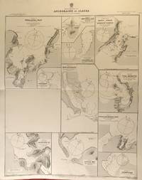
America - North West Coast. Anchorages in Alaska. From Plans published by the United States Government.
by Alaska Nautical Chart
- Used
- Condition
- See description
- Seller
-
Sidney, British Columbia, Canada
Payment Methods Accepted
About This Item
London: British Admiralty, 1890 (1924). . An engraved chart on heavy stock, uncolored, sheet size 27 x 33.5 inches. Published 2nd Aug. 1890; Large Corrections to Nov. 1908; Small corrections (printed) to 1924 and (mss.) to 1929. Original horizontal fold, a nice clean copy, small additions in red pen. In lower right: "Engraved by Edwd. Weller". Chart number is 1457. Small typed label on verso giving chart & folio info. Published under the Superintendence of Captain W.J.L. Wharton. Eleven anchorages: Unalaska Bay (Captains Bay), Cape Etolin, Simeonof I. & Hr., Samganuda Bay, Popof Strait and Humboldt Harbour, Port Mulgrave, Coal Harbour, Doris & Anchorage Bays, Nateekin Bay, Liituya Bay, and Sanborn Hr.
Reviews
(Log in or Create an Account first!)
Details
- Bookseller
- William Matthews, Bookseller / The Haunted Bookshop
 (CA)
(CA)
- Bookseller's Inventory #
- 56424
- Title
- America - North West Coast. Anchorages in Alaska. From Plans published by the United States Government.
- Author
- Alaska Nautical Chart
- Book Condition
- Used
- Quantity Available
- 1
- Publisher
- London: British Admiralty, 1890 (1924).
- Bookseller catalogs
- Maps;
Terms of Sale
William Matthews, Bookseller / The Haunted Bookshop
Prices are in US Dollars. Books are guaranteed to be as described. Books may be returned within a reasonable length of time. Paypal Payments are made to: bill@rainbownorth.com
About the Seller
William Matthews, Bookseller / The Haunted Bookshop
Biblio member since 2004
Sidney, British Columbia
About William Matthews, Bookseller / The Haunted Bookshop
Established 1976. Open shop in Victoria BC, Open Wed-Sun 11-5. Specialists in weird, fantastic, supernatural,utopian, interplanetary, science fiction and lost race fiction; also rare books, literary first editions, poetry broadsides. Antiquarian maps, charts, views, prints, engravings.
This Book’s Categories

Collecting food and drink books
Nothing quite whets the appetite for rare and collectible books like old and vintage cookbooks. Be sure to check out our cook books and food section of our rare book room.

How to tell if a signature is genuine
Author's signatures can undoubtedly increase the value of a rare book or first edition. The more scarce the book is, the more an autograph adds to its value. But how to tell if the signature is real? Find out how you can avoid common pitfalls in identifying an author's signature.
