Click for full-size.


Highway Map and Guide of California & Nevada
by [California]. [Nevada]. [Automobiles]
- Used
- Condition
- Very good.
- Seller
-
Dobbs Ferry, New York, United States
Payment Methods Accepted
About This Item
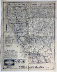
Aurora, Mo: Midwest Map Company, 1930. Very good.. Folding map, 22 x 17 inches. Old fold lines, some light wear. Folding highway map of California and Nevada, with extensive advertising for the Tulare Motor Inn in Tulare, California. The advertising section is printed in red, while the rest of the map is printed in blue. The map key delineates paved, improved, and earth roads, as well as connecting county roads. Interestingly, almost none of Nevada's roads are paved; the stretch of road from Carmel to San Simeon, through Big Sur, is a combination of improved and unpaved. Numerous small towns are marked, as are national parks. It seems likely that the general map information was printed with space left for custom sponsorship, such as that of the Tulare Motor Inn on the present example. One copy in OCLC, at Cornell University.
Reviews
(Log in or Create an Account first!)
Details
- Bookseller
- McBride Rare Books
 (US)
(US)
- Bookseller's Inventory #
- 964
- Title
- Highway Map and Guide of California & Nevada
- Author
- [California]. [Nevada]. [Automobiles]
- Book Condition
- Used - Very good.
- Quantity Available
- 1
- Publisher
- Midwest Map Company
- Place of Publication
- Aurora, Mo
- Date Published
- 1930
Terms of Sale
McBride Rare Books
All items are guaranteed as described. Any purchase may be returned for a full refund within 10 working days as long as it is returned in the same condition and is packed and shipped correctly. All items subject to prior sale.
About the Seller
McBride Rare Books
Biblio member since 2018
Dobbs Ferry, New York
About McBride Rare Books
We specialize in American history, focusing on unique and eclectic materials such as archives, broadsides, vernacular photography, and interesting or unusual imprints. Particular fields of interest include Western Americana and Latin America.
This Book’s Categories

Collecting the Harlem Renaissance
One of the most influential - and certainly most iconic - cultural revolutions in American history, the Harlem Renaissance offers a compelling repertoire for both seasoned and novice book collectors. We’ve put together a beautiful gallery of high points to help start your collection here.

Collecting Arkham House
Learn about collecting the iconic horror and fantasy publisher that produced books by the likes of Ray Bradbury, August Derleth and H. P. Lovecraft.