Description:
Speed, John : Cheshire. The Countye Palatine of Chester with that most Ancient Citie described. Basset & Chiswell, [London, 1610-1676]. Size approx 510mm x 380mm ( 20 x 15 inches). Early hand coloured double page copper engraved map. From Speed's "The Theatre of the Empire of Great Britain" with English text on verso and a description of the county and a gazetteer. Inset town plan of Chester. Seven coast of arms of "The Armes of the Earles of Chester since the Norman Conquest". Four decorative cartouches. Speed has used William Smith's revisions of Saxton and the Braun & Hogenberg plan of Chester. Good margins. Very small hole (approx 2mm or 1/10in) in the decorative border, otherwise fine condition. A strong dark impression of this famous decorative county map of Cheshire.
Historical Atlas Map of Marion & Linn Counties Oregon; Compiled, Drawn and Published from Personal Examinations and Actual Surveys by Edgar Williams & Co - 1878
by Edgar Williams & Co
Similar copies are shown below.
Similar copies are shown to the right.

Historical Atlas Map of Marion & Linn Counties Oregon; Compiled, Drawn and Published from Personal Examinations and Actual Surveys
by Edgar Williams & Co
- Used
- very good
- first
San Francisco: Edgar Williams & Co, 1878. First Edition. Very Good. Folio, [17.5x14.5in]; [5], index, 6-104 pp., 40 pages of 24 hand-colored maps and 31 hand-colored City, Town and Village plats (all but one on double-pages), 58 lithographic illustrations of residences, farms, ranches and commercial properties, 49 biographies of noted property owners, and other information on Marion and Linn Counties; Original Half bound in dark brown cloth and black morocco with blind stamped design on front and back, gilt lettering on front, all edges trimmed, red ink tinted edges; Typical wear to covers, edges and corners with the some fraying of the cloth at the edge of the spine leather backing, rubbing on all edges and corners bumped with portions fraying to exposed boards, hinges loose and front holding by hinge reinforced tape binding, end papers fragile and text block edges worn with small chips, red tint edges faded, some soiling and finger smudges along edges of text block and margins of pages, maps and illustrations are bright and clean, except as noted. This was the first county atlas of Oregon. The Atlas is complete with very detailed maps including geographical, commercial and political features. The illustrations depict the residences, farms, commercial activities and public buildings in the counties with great detail. Also included is the history of the counties and leading citizen's biographical narratives provide much detail to the settlement of the counties. Marion and Linn counties are the heart of the Willamette Valley and the population center of Oregon in the 1870's. The capitol city of Salem and major city of Albany are in these counties. Also includes tipped in local newspapers Greater Oregon, Albany, April 13, 1945, pages 3 - 6; Greater Oregon, February 5, 1937, complete pages 1-8; Herald-Disseminator, Albany, February 1, 1889, complete; State Rights Democrat, Albany, October 7, 1870, complete, very fragile; State Rights Democrat, Albany, March 13, 1869, complete, very fragile.
-
Bookseller
David Spilman Fine Books, ABAA & IOBA
 (US)
(US)
- Book Condition Used - Very Good
- Quantity Available 1
- Edition First Edition
- Publisher Edgar Williams & Co
- Place of Publication San Francisco
- Date Published 1878
We have 2 copies available starting at A$3,098.80.
![The Countye Palatine of Chester with that most Ancient Citie described. [Cheshire], John Speed,...](https://d3525k1ryd2155.cloudfront.net/h/266/067/50067266.0.m.jpg)
More Photos
The Countye Palatine of Chester with that most Ancient Citie described. [Cheshire], John Speed, [1676]
by John Speed
- Used
- very good
- Condition
- Used - Very Good
- Edition
- Basset & Chiswell, [London, 1610-1676].
- Quantity Available
- 1
- Seller
-
Plymouth, Devon, United Kingdom
- Item Price
-
A$1,453.65
Show Details
Item Price
A$1,453.65

More Photos
Chios. "Chios Maris Aegæ ieiusdem nominis Insulae Civitas
by Braun & Hogenberg
- Used
- Condition
- Used
- Binding
- Unknown
- Quantity Available
- 1
- Seller
-
Nafplion, Greece
- Item Price
-
A$1,992.00
Show Details
Description:
Greece: Cologne G von Kempen 1588. Copper engraved view of Chios from the fourth volume of Braun & Hogenberg's "Civitas Orbis Terrarum. " Latin text to verso; black & white as issued. The engraving shows the port and capital of Chios, seen from the east in a bird's-eye view. The town is represented as divided into the strongly fortified Byzantine Kastro and the town itself, which is defended on the landward side by massive watchtowers with a moat and a drawbridge. Windmills line the coast; A canon fire s out to sea from a tower on the sea wall; numerous ships and galleys. Decorative title cartouche The city is often locally referred to as "Chora" (Χώρα; literally meaning "town") or "Kastro" (Κάστρο) to distinguish it from the entirety of the island with which it shares the name. Originally the site of an ancient settlement, the town was first built at the north side of a natural harbour. By the 16th century, the walled town had been further fortified by successive rulers into a massive…
Read More Item Price
A$1,992.00

More Photos
Travels in the Interior Districts of Africa: Performed under the direction and patronage of the african association, in the years 1795, 1796, and 1797. with an appendix, containing illustrations of Africa by Major Rennel
by PARK, Mungo
- Used
- very good
- Hardcover
- Condition
- Used - Very Good
- Edition
- 2nd
- Binding
- Hardcover
- Quantity Available
- 1
- Seller
-
Cuernavaca, Mexico
- Item Price
-
A$2,463.55
Show Details
Description:
London, W.Bulmer and Co., 17994º. xxviii,(2),372 pp., xcii. Bound to style in a fine later calf. Title-and tomelabels with gilt lettering. Blindtoolings to bands and compartments of spine. Engraved portrait as frontispiece, 2 engraved plates with music, 5 engraved plates (of which 3 are views) and 3 large folded engraved maps. One map strenghtened in foldings and edges, one map with a closed tear to folding. Wide-margined, a few margins slightly brownspotted. Light offsetting to title and portrait.
Second edition - the same year as the first - of this classic work of travel litterature.
"Until the publicationof Park's book in 1799 hardly anything was known of the interior of Africa, apart from the north-east region and coastal areas....the real opening up of Africa by the white races began with the African Association, founded in 1788 with the express purpose of exploring Africa and furthering British tradee and political influence onthe continent...Parks travels had an immediate success and was… Read More
Item Price
A$2,463.55
![Alaska and Klondike Region; [With inset of Klondike Region on the Upper Yukon detail] [From an...](https://d3525k1ryd2155.cloudfront.net/h/062/537/1339537062.0.m.jpg)
Alaska and Klondike Region; [With inset of Klondike Region on the Upper Yukon detail] [From an atlas, "Gazetteer of Alaska and Yukon Region " pp. 105 and 106]
by Miller, J. Martin
- Used
- very good
- Condition
- Used - Very Good
- Edition
- Unknown
- Binding
- Unknown
- Quantity Available
- 1
- Seller
-
Sebastopol, California, United States
- Item Price
-
A$60.43
Show Details
Description:
Chicago: J. Martin Miller, 1899. Unknown. Map. Very Good. [Map copyright 1899, printing date of Atlas later] [19.875x15.125in]; Colored map of Alaska with steamer routes from Portland and Seattle, insets of the Klondike Region on the Upper Yukon and Western portion of Aleutian Islands; On verso index of places and names with two large black and white images; Age toning to all edges, water stain marks on bottom, slight printing offset of colors, small chips and closed tears to lower edge;.
Item Price
A$60.43
![Northern Regions; [Published in Colton's General Atlas, 1861 as No. XII]](https://d3525k1ryd2155.cloudfront.net/h/569/126/1453126569.0.m.jpg)
Northern Regions; [Published in Colton's General Atlas, 1861 as No. XII]
by Colton, George
- Used
- very good
- first
- Condition
- Used - Very Good
- Edition
- First State, Later Printing
- Binding
- Unknown
- Quantity Available
- 1
- Seller
-
Sebastopol, California, United States
- Item Price
-
A$260.30
Show Details
Description:
New York: J. H. Colton & Co, 1855. First State, Later Printing. Very Good. [14x11in Neatline, 17.5x14.25in Sheet]; Map with distinctive Colton borders of discovered Arctic features land features; Some age-toning and light stains along edges [Rumsey Collection 2441.008]. The Northern Regions map was initially drawn and engraved for publication in Colton's General Atlas of 1855. Colton reissued atlases in different formats, pagination, collation and map updates over the years. This map was from the 1861 issue and distinctive in the roman numerals format and number placement. The map has not been altered since 1855. The map does not show still to be discovered Wrangel Is.( late 1860's), Franz Joseph land (1873) , or the northern Greenland coast line (Late 1890's). The map shows the future Alaska as "Russian Possessions" (acquired by the United States in 1868). The map also noted the "Open Polar Sea", one of the many theories yet to be discovered and corrected about the Arctic.
Item Price
A$260.30

TOPOGRAPHICAL SURVEY OF THE GREAT ROAD FROM LONDON TO BATH AND BRISTOL. With historical and descriptive accounts of the country, towns, villages, and gentlemen's seats on and adjacent to it; illustrated by perspective views of the most select and picturesque scenery. To which is added a correct map of the country three miles on each side of the road, planned from a scale of one inch to a mile.
by Robertson,Archibald
- Used
- Hardcover
- Condition
- Used - Very Good-
- Binding
- Hardcover
- Quantity Available
- 1
- Seller
-
Blockley, Gloucestershire, United Kingdom
- Item Price
-
A$2,062.24
Show Details
Description:
London: For the author & William Faden (replaced by R.Faulder in vol.2), 1792. Hardcover. Very Good-. Aquatint plates (65 as listed) + 11 folding Maps. . 2 VOLUMES IN ONE 223x141mm green calf gilt key pattern border & spine gilt, gilt dent. & rev. (tips & hinges rubbed/spine darkened) All Edges Gilt Dedication to Prince of Wales the future George IV. TP + xvi =Dedic.+Introduction + contents & plate list +154pp Titlepage to Part II +viii=Contents & Plate list + 190pp+errata + 11 folding Maps. Coat of Arms bookplate James Forbes esq. & F.Fisher written in. Short tears to gutter edge - no loss - to first 3 leaves else a clean copy. Slight offset from plates to facing text but no foxing and great views with horses, coaches, people, boats etc. The maps without and misfold or tears -they look unused. A clean copy of a lovely aquatint book.
Item Price
A$2,062.24
More Photos
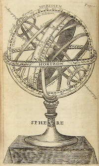
L'USAGE DES GLOBES CELESTES ET TERRESTRES, ET DES SPHERES, SUIVANT LES DIFFERENS SYSTEMES DU MONDE. PRÉCEDÉ D'UN TRAITÉ DE COSMOGRAPHIE, OÙ EST EXPLIQUÉ AVEC ORDRE TOUT CE QU'IL Y A PLUS CURIEUX DANS LA DESCRIPTION DE L'UNIVERS, SUIVANT LES MEMOIRES & OBSERVATIONS DES PLUS HABILES ASTRONOMES & GEOGRAPHES. . .
by Bion, Nicolas
- Used
- near fine
- Hardcover
- first
- Condition
- Used - Near fine
- Edition
- First Edition
- Binding
- Hardcover
- Quantity Available
- 1
- Seller
-
Brooklyn, New York, United States
- Item Price
-
A$1,704.34
Show Details
Description:
Paris: Chez l'auteur... Laurent d'Houry... Jean Boudot, libraire..., 1699. 12mo. [18],300;112 pp. plus 26 plates (three folding). Contemporary speckled calf, spine richly gilt, gilt leather label, raised bands, edges rouged. Light institutional inkstamp in title page. 18th-century inscription in titlepage and signature of Theophile Leonard in title page and final page of the dedication. Occasional 18th-century marginalia. Minor wear. Near fine. First edition of the first major work of Nicolas Bion, complete with 26 plates of terrestrial and celestial maps, diagrams, and images of globes. Bion (ca. 1652-1733) was a Paris-based cosmographer and maker of mathematical and astronomical instruments, holding the title of "king's engineer for mathematical instruments" under Louis XIV (DSB II, pp. 132-1330). A landmark in its field.
Item Price
A$1,704.34
Alaska and Klondike Region; [With inset of Klondike Region on the Upper Yukon detail] [From an atlas, "Gazetteer of Alaska and Yukon Region " pp. 105 and 106]
by Miller, J. Martin
- Used
- very good
- Condition
- Used - Very Good
- Edition
- Unknown
- Binding
- Unknown
- Quantity Available
- 1
- Seller
-
Sebastopol, California, United States
- Item Price
-
A$60.43
Show Details
Description:
Chicago: J. Martin Miller, 1899. Unknown. Map. Very Good. [Map copyright 1899, printing date of Atlas later] [19.875x15.125in]; Colored map of Alaska with steamer routes from Portland and Seattle, insets of the Klondike Region on the Upper Yukon and Western portion of Aleutian Islands; On verso index of places and names with two large black and white images; Age toning to all edges, water stain marks on bottom, slight printing offset of colors, small chips and closed tears to lower edge;.
Item Price
A$60.43
More Photos
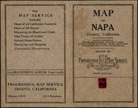
Napa County California. 1914
by Copyright 1914 by Punnett Brothers
- Used
- Condition
- Used
- Quantity Available
- 1
- Seller
-
FRAMINGHAM, Massachusetts, United States
- Item Price
-
A$1,471.93
Show Details
Description:
Map Details and Condition:color lithograph
dimensions: 26 3/4" x 19"
Brown Paper pocket covers with red bookstore label of Neal Stratford & Kerr, San Francisco
condition: professionally flattened and otherwise in as found, very good conditionDescription:
This 1914 map of now popular wine country Napa County, California shows the county in 1914, with early roads, largely undeveloped, vast open land areas, and natural features. The numbered grid system on this map reflects the Public Land Survey System. Large open tracts of land are identified as ranches, such as Rancho Catacoula, or Rancho Las Putas, Rancho LaJota all of which are large swaths of undivided land. Urban grids are shown in the southernmost part of Napa County, and sections of the southernmost sections of Sonoma County and Solano County. The cities of Petaluma, Sonoma, Vallejo and Napa and Benicia show populated urban areas. A corner of Marin County is shown.
C.F. Weber & Co. and the Punnett Brothers published… Read More
Item Price
A$1,471.93
Northern Regions; [Published in Colton's General Atlas, 1861 as No. XII]
by Colton, George
- Used
- very good
- first
- Condition
- Used - Very Good
- Edition
- First State, Later Printing
- Binding
- Unknown
- Quantity Available
- 1
- Seller
-
Sebastopol, California, United States
- Item Price
-
A$260.30
Show Details
Description:
New York: J. H. Colton & Co, 1855. First State, Later Printing. Very Good. [14x11in Neatline, 17.5x14.25in Sheet]; Map with distinctive Colton borders of discovered Arctic features land features; Some age-toning and light stains along edges [Rumsey Collection 2441.008]. The Northern Regions map was initially drawn and engraved for publication in Colton's General Atlas of 1855. Colton reissued atlases in different formats, pagination, collation and map updates over the years. This map was from the 1861 issue and distinctive in the roman numerals format and number placement. The map has not been altered since 1855. The map does not show still to be discovered Wrangel Is.( late 1860's), Franz Joseph land (1873) , or the northern Greenland coast line (Late 1890's). The map shows the future Alaska as "Russian Possessions" (acquired by the United States in 1868). The map also noted the "Open Polar Sea", one of the many theories yet to be discovered and corrected about the Arctic.
Item Price
A$260.30

Historical Atlas Map of Marion & Linn Counties, Oregon. Compiled, Drawn and Published from Personal Examinations and Actual Surveys
by Edgar Williams & Co
- Used
- Hardcover
- first
- Condition
- Used - Very Good-
- Edition
- First Edition
- Binding
- Hardcover
- Quantity Available
- 1
- Seller
-
Lincoln City, Oregon, United States
- Item Price
-
A$3,098.80
Show Details
Description:
San Francisco: Edgar Williams & Co.. Very Good-. 1878. First Edition. Hardcover. In the original three-quarter leather. The cloth and corners are rubbed all around. The title page and last page have small tape repairs at the edges. The spine leather may be a replacement; hard to tell. ; Folio 13" - 23" tall; 104 pages .
Item Price
A$3,098.80
Historical Atlas Map of Marion & Linn Counties, Oregon. Compiled, Drawn and Published from Personal Examinations and Actual Surveys
by Edgar Williams & Co
- Used
- very good
- Hardcover
- first
- Condition
- Used - Very Good
- Edition
- First Edition
- Binding
- Hardcover
- Quantity Available
- 1
- Seller
-
Lincoln City, Oregon, United States
- Item Price
-
A$3,408.68
Show Details
Description:
San Francisco: Edgar Williams & Co.. Very Good. 1878. First Edition. Hardcover. Bound in three-quarter black leather. The spine has been professionally repaired with black leather. The cloth is rubbed and soiled. Some finger marks and slight foxing to the contents. ; Folio 13" - 23" tall; 104 pages .
Item Price
A$3,408.68

More Photos
The Sky and the Forest
by Forester, C.S
- Used
- very good
- Hardcover
- first
- Condition
- Used - Very Good
- Jacket Condition
- Very Good
- Edition
- First Edition
- Binding
- Hardcover
- Quantity Available
- 1
- Seller
-
Salem, Oregon, United States
- Item Price
-
A$54.06A$32.43Save A$13.96!
Show Details
Description:
C.S. Forester: The Sky and the Forest. Little, Brown and Company, Boston. Stated First Edition First Printing Thus August, 1948. Cover price $2.75. Used. VG BOOK/VG UNCLIPPED DUST JACKET. A story of a central Africa. By C.S. Forester, author of the Admiral Hornblower series.
Item Price
A$54.06A$32.43
Save A$13.96
!
Alaska and Klondike Region; [With inset of Klondike Region on the Upper Yukon detail] [From an atlas, "Gazetteer of Alaska and Yukon Region " pp. 105 and 106]
by Miller, J. Martin
- Used
- very good
- Condition
- Used - Very Good
- Edition
- Unknown
- Quantity Available
- 1
- Seller
-
Sebastopol, California, United States
- Item Price
-
A$60.43
Show Details
Description:
Chicago: J. Martin Miller, 1899. Unknown. Map. Very Good. [Map copyright 1899, printing date of Atlas later] [19.875x15.125in]; Colored map of Alaska with steamer routes from Portland and Seattle, insets of the Klondike Region on the Upper Yukon and Western portion of Aleutian Islands; On verso index of places and names with two large black and white images; Age toning to all edges, water stain marks on bottom, slight printing offset of colors, small chips and closed tears to lower edge;.
Item Price
A$60.43

Zemepis Sveta - Monsunova Asie
by De La Blache, P. Vidal; Gallois, L
- Used
- Hardcover
- Condition
- Used - Very Good Condition
- Jacket Condition
- No Dust Jacket
- Binding
- Hardcover
- Quantity Available
- 1
- Seller
-
Oak Point, Texas, United States
- Item Price
-
A$92.96
Show Details
Description:
Aventinum, Prague, Czechoslovakia, 1930. Hardcover. Very Good Condition/No Dust Jacket. Text entirely in Czech. Geography book on Asia with numerous photographs and maps. 1931 edition also available. Size: 4mo - over 9 3/4" - 12" tall. 400 pp. Pages are yellowed, but are tight and clean. Moderate shelfwear along the spine. Corners are lightly bumped. Quantity Available: 1. Shipped Weight: 3-5 pounds. Category: Travel & Places; Non-English Language::Czech; Pictures of this item not already displayed here available upon request. Inventory No: 001227. . Additional shipping charges may apply.
Item Price
A$92.96

Zemepis Sveta - Monsunova Asie
by De La Blache, P. Vidal; Gallois, L
- Used
- Hardcover
- Condition
- Used - Very Good Condition
- Jacket Condition
- No Dust Jacket
- Binding
- Hardcover
- Quantity Available
- 1
- Seller
-
Oak Point, Texas, United States
- Item Price
-
A$92.96
Show Details
Description:
Aventinum, Prague, Czechoslovakia, 1931. Hardcover. Very Good Condition/No Dust Jacket. Text entirely in Czech. Geography book on Asia with numerous photographs and maps. 1930 edition also available. Size: 4mo - over 9 3/4" - 12" tall. 400 pp. Pages are yellowed, but are tight and clean. Moderate shelfwear along the spine. Corners are lightly bumped. Quantity Available: 1. Shipped Weight: 3-5 pounds. Category: Travel & Places; Non-English Language::Czech; Pictures of this item not already displayed here available upon request. Inventory No: 001228. . Additional shipping charges may apply.
Item Price
A$92.96

Asia from the Best Authorities, Russell, ca.1800
by Russell
- Used
- Condition
- Used
- Quantity Available
- 1
- Seller
-
Plymouth, Devon, United Kingdom
- Item Price
-
A$38.76
Show Details
Description:
Russell, J. : Asia from the Best Authorities. Nd but ca.1800. From "A New Geographical, Historical and Commercial Grammar and Present State of Several Kingdoms of the World". Copper engraving. Size approx 200 x 230mm. Two neat folds. Some age colouring to edges, otherwise clean and bright. Includes Arabia, India, Borneo, Japan, China and eastern Russia.
Item Price
A$38.76

North America from the Best Authorities, Russell, ca.1800
by Russell
- Used
- Condition
- Used
- Quantity Available
- 1
- Seller
-
Plymouth, Devon, United Kingdom
- Item Price
-
A$38.76
Show Details
Description:
Russell, J. : A General Map of North America from the Best Authorities. Nd but ca.1800. From "A New Geographical, Historical and Commercial Grammar and Present State of Several Kingdoms of the World." Copper engraving. Size approx 200 x 230mm. Two neat folds. Some age colouring to edges, otherwise very clean and bright.
Item Price
A$38.76
![MAP OF UTAH [Territory]](https://d3525k1ryd2155.cloudfront.net/h/836/461/1485461836.0.m.jpg)
More Photos
MAP OF UTAH [Territory]
- Used
- Condition
- Used - Very Good-
- Edition
- Original
- Quantity Available
- 1
- Seller
-
Williamsburg, Virginia, United States
- Item Price
-
A$100.71
Show Details
Description:
New York, Richmond, Chicago, & Toledo: H. H. Hardesty, 1885. Original color lithographed map printed by Rand, McNally & Company, Engravers and published in HARDESTY'S HISTORICAL AND GEOGRAPHICAL ENCYCLOPEDIA: SPECIAL VIRGINIA EDITION. 19 3/8 inches by 13 1/4 inches on a 21" X 14 1/2" sheet. The map depicts the Territory of Utah in its final form--large areas had been removed and ceded to Nevada, Colorado, Wyoming, and Nebraska since Utah became a U. S. Territory in 1850. The issue of polygamy prevented statehood until it was finally granted in 1896. This map features railroads and topography and uses color to set off counties from each other. Unlike most atlas maps of the period, this map identifies most small towns. The map is guaranteed to be moe than 135 years old. The map is in about very good condition: generally clean and bright, with slight toning of paper and one faint water stain near the center-left edge of the map.. Original. Single Sheet. Very Good-. Elephant…
Read More Item Price
A$100.71

Philips Special Map of the Nile, The Advance on Khartum and the Environs of Omdurman. Cc1900
by George Philips and Son,
- Used
- Condition
- Used
- Quantity Available
- 1
- Seller
-
Plymouth, Devon, United Kingdom
- Item Price
-
A$50.39
Show Details
Description:
Philips Special map of the Nile illustrating the Advance on Khartum [Khartoum] with an enlargement of the environs of Omdurman [Omdur]. George Philips and Son, London and Liverpool Ca 1900. 580mm x 900mm folded map. Front title wrapper has come loose, not affecting map area. Three maps are displayed within the sheet. Map1. Map of the Nile Valley 520mm x 300mm showing the approaches of Khartum. Scale 1inch to 100 Geographical miles. Coloured indicating Possessions and Protectorates of European Powers. Map 2. Special map of the Nile from Dongola to Khartum. Scale 16 miles to the inch. Coloured. In set in this map is Map3. Environs of Omdurman, Scale 5 statute miles to the inch. Some small breaks at some folds, not affecting imagery or use of map. Title label is damaged, the map is clean and bright, probably unused. A very interesting record.
Item Price
A$50.39

Last Tales
by Dinesen, Isak
- Used
- very good
- Hardcover
- first
- Condition
- Used - Very Good
- Jacket Condition
- Good+
- Edition
- First Edition
- Binding
- Hardcover
- Quantity Available
- 1
- Seller
-
Salem, Oregon, United States
- Item Price
-
A$185.93A$111.56Save A$48.00!
Show Details
Description:
Dinesen, Isak: Last Tales, A Collection of Twelve New Tales of Compelling Beauty 1957, Random House. First Edition. Stated First Printing Thus. Used. Very Good/Good+ original red dust jacket, price-clipped. Jacket states 11/57 on front flap. 5 3/4 X
Item Price
A$185.93A$111.56
Save A$48.00
!

The Adventure of Wrangel Island
by Vilhjalmur Stefansson
- Used
- good
- Hardcover
- first
- Condition
- Used - Good
- Jacket Condition
- No DJ Included
- Edition
- First Edition
- Binding
- Hardcover
- Quantity Available
- 1
- Seller
-
Salem, Oregon, United States
- Item Price
-
A$193.50A$116.10Save A$49.96!
Show Details
Description:
The Adventure of Wrangel Island, Alaska (1925 Macmillan 1st Edition) HISTORY OF ALASKA. EXLIB. Good Condition/ No DJ included. Fold-out map affixed to binding at the back of the book has never been opened. The story of the (unsuccessful) attempted colonization of Wrangel Island Alaska. 413 pages plus appendix, Index. Titling is still bright. A clean, solid copy. Scarce.
Item Price
A$193.50A$116.10
Save A$49.96
!