BIBLIO is the largest independent book marketplace in the world, with over 100 million books.

Skip to content

Original Antique Maps

FRAMINGHAM, Massachusetts, USA

Original Antique Maps specialises in 18th & 19th C. American Newspapers, 19th C. Children's Books, School Geographies, American Wall Maps, Maps, Surveys And Charts, Americana, Prints And Manuscript, Photography, Hawaii - Sandwich Islands, Pictorial Maps, Urban Planning, Land Use And Land Form Maps

About Original Antique Maps

Rare and unusual 18th and 19th century Americana, American and International maps, atlases, prints, nautical charts and manuscript maps. My interests include American 19th century newspapers and manuscript materials such as letters. Maps of the 20th c. including advertising, transit and urban planning are of special interest. Original art on paper in its many forms, including posters and field studies for ultimate print publication.
Biblio Member since
2020

Contact Original Antique Maps

Original Antique Maps

P.O.Box 3003
FRAMINGHAM, MA 01705 USA
Phone: (508) 820-9100

Terms of sale for Original Antique Maps

30 day return guarantee, with full refund including original shipping costs for up to 30 days after delivery if an item arrives misdescribed. If an item arrives damaged, please contact Original Antique Maps immediately to report the damage and discuss whether the original shipping materials may still be used to return the item and for return shipping instructions. Original Antique Maps will fully refund buyer's payments and pay for the return shipping of any damaged item. Buyer will be paid following receipt by Original Antique Maps of the returned item. Otherwise, returns as per www.spackantiquemaps.com.Buyer will be advised of shipping and handling charges that exceed standard charges to buyer.

Accepted payment methods

  • Visa
  • Mastercard
  • American Express
  • Discover
  • Paypal
  • Venmo
  • Apple Pay
  • Google Pay

Browse books by Author

Browse books by Title

Original Antique Maps is a member of:

  • Antiquarian Booksellers' Association of America Logo

Rare Books from Original Antique Maps

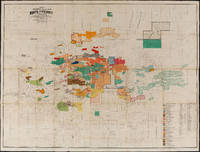
Map of Mining Claims Butte and Vicinity Montana (1907)

by Harper, Macdonald & Co., J.H. Harper, A.B. Hobart, R.H. Lindsay, Jr., Mineral & Land Attorneys & U.S. Mineral Land Surveyors

Condition
Used
Quantity available
1
Seller
FRAMINGHAM, Massachusetts, United States
Item price
A$1,156.64
Item price
A$1,156.64

Show details

Description:
Map Details:Scale 1"=1,200' (manuscript pencil above printed scale)color lithograph
dimensions: 37 1/2" x 49" sheet size
maroon pocket covers: 8 7/8" x 5 1/8" x 3/4"
condition: professional conservation to reattach lifted paper at original folds. Some paper loss at folds, bright colors with some fading. Paper shows wear from actual use, including pencil notations on map's color key of claimants.
provenance: manuscript inside pocket cover identifying two prior owners, W.B. Brinker (Butte) and C.A. Lemmon, Anaconda, MontanaDescription:
Harper, Macdonald & Co. published maps of Butte, Montana mining claims as early as 1901. This 1907 map edition of Mining Clams Butte and Vicinity Montana is referred to in certain literature as the first edition of its series. The 1907 copyright date of this map and its 1907 publication date therefore identify this map is the first edition of its series. The series was published until at least 1913. The Harper, Macdonald firm included pro…Read more

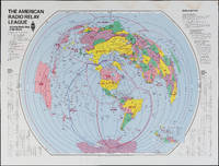
The Amateur Radio Relay League

by American Radio Relay League

Condition
Used
Quantity available
1
Seller
FRAMINGHAM, Massachusetts, United States
Item price
A$469.88
Item price
A$469.88

Show details

Description:
Color print on glossy paperDimensions: 31" x 40 3/4"Condition: as found, water stain along top margin, bright colors throughoutThis American Radio Relay League divides the world into radio relay league zones rather than political or geographic boundaries. The map could be thought of as a ham radio listeners "bird's ear" view of the world. Each zone is identified by the call letters for that zone, immediately recognizable to the experienced ham radio operator and part of a language unique to this kind of radio communication.

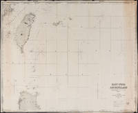
East India Archipelago Chart No. 7 (1878)

by James Imray and Son

Condition
Used
Quantity available
1
Seller
FRAMINGHAM, Massachusetts, United States
Item price
A$1,301.22
Item price
A$1,301.22

Show details

Description:
Chart Details:
black and white engraving, navigation lights marked with red and yellow, blue backed
Blue ink stamp next to title block: "Imray & Son London 1878"
Publisher's original paper label glued to back of chart
condition: as found rolled, top left corner approx. 2" piece missing that includes some of perimeter printed border of chart, overall a clean chart with some spotting on edges, some spotting in vicinity of title block, paper toned along right vertical edge chart, edges overall in good condition, this chart was used to plot several voyages and has manuscript pencil notes with dates

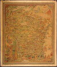
Published by the Milwaukee Sentinel Commemorating Its One Hundredth Anniversary June 27, 1937

by Copyright 1932 by Erwin F. Bahlmann and Artist Nina S. Bahlman

Condition
Used
Quantity available
1
Seller
FRAMINGHAM, Massachusetts, United States
Item price
A$939.77
Item price
A$939.77

Show details

Description:
Map Details and Condition:
color lithograph by Litho in U.S.A.
dimensions: 24" x 28.5 " print, 26 1/4" x 30" sheet size
condition: professionally removed from wood backing and restored, deeply toned paper, some surface damage to paper, repaired vertical tear through sheet, backed with Japanese Mulberry tissue, some chipping at edges Map Description:
This scarce Wisconsin pictorial map was created by the artist Nina S. Bahlman (b1886-___) whose art work other than this map may exist in collections but is not readily identified. The copyright is held by Erwin F. Bahlmann (b.1886-__) a family member or spouse. The Library of Congress cites its copy of this map as Historical Map of Wisconsin and cites a 1995 copyright registration. WorldCat confirms that there is a 1995 reprint of this map. A further note corrects the spelling of the artist's name to read "Bahlmann". The example of the map on offer gives every appearance of being the 1932 edition.
The map was published by the …Read more

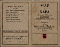
Napa County California. 1914

by Copyright 1914 by Punnett Brothers

Condition
Used
Quantity available
1
Seller
FRAMINGHAM, Massachusetts, United States
Item price
A$1,373.51
Item price
A$1,373.51

Show details

Description:
Map Details and Condition:
color lithograph
dimensions: 26 3/4" x 19"
Brown Paper pocket covers with red bookstore label of Neal Stratford & Kerr, San Francisco
condition: professionally flattened and otherwise in as found, very good conditionDescription:
This 1914 map of now popular wine country Napa County, California shows the county in 1914, with early roads, largely undeveloped, vast open land areas, and natural features. The numbered grid system on this map reflects the Public Land Survey System. Large open tracts of land are identified as ranches, such as Rancho Catacoula, or Rancho Las Putas, Rancho LaJota all of which are large swaths of undivided land. Urban grids are shown in the southernmost part of Napa County, and sections of the southernmost sections of Sonoma County and Solano County. The cities of Petaluma, Sonoma, Vallejo and Napa and Benicia show populated urban areas. A corner of Marin County is shown.
C.F. Weber & Co. and the Punnett Brothers published several ser…Read more

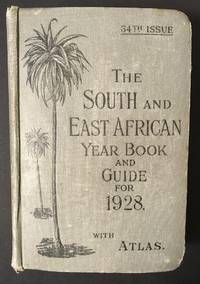
The South and East African Year Book Guide. With Atlas and Diagrams. 34th Issue owned by A. Jessop

by Edited Annually By A. Samler Brown, F.R.M.S. & G. Gordon Brown, F.R.G.S

  • Hardcover
Condition
Used
Edition
34th
Binding
Cloth over illustrated boards
Quantity available
1
Seller
FRAMINGHAM, Massachusetts, United States
Item price
A$397.59
Item price
A$397.59

Show details

Description:
Contents and Condition:Union-Castle Atlas pp. 2-64 with color maps, single and double page, George Philips & Son, Geographical Institute, London
"Advertisements South Africa, Capetown with East Africa Route", pp. 1-129.
dimensions: 7 3/8" x 5 1/2" x 1 5/8"
condition: decorated fabric covers show mild wear, binding tight, front cover attached with weakening at bottom of binding
owner's name in manuscript ink on title page: "A.Jessop Coronado, California, U.S.A"Description:
This densely informative travel guide was owned by A. Jessop of Coronado, California. The A. Jessop who owned this book is most likely a son of Joseph Edward Jessop, an English watchmaker and jewelry store owner who with his wife emigrated from London, England to California, seeking to settle in the San Diego area with their children. The Jessop family established a jewelry store that became multi-generational in the San Diego, California area. In 1901 the Jessop family moved to Coronado, California. In 1907, Mr. Jessop introduce…Read more