Description:
Borough of Hopatcong, New Jersey?, 1912. Near Fine condition. SEE PHOTO. This is a beautiful and very scarce color map of Lake Hopatcong, New Jersey. When unfolded it measures 18" tall by 38" wide. Some folds have been neatly reinforced on the blank side with archival-quality document repair tape. Buildings are represented by red squares, water in green. Some of the properties and locations depicted are: Port Morris, Landing, Roxbury Township, Borough of Mount Arlington, Byram Township, Nolans Point, Atlas Powder Co., Brookland, Borough of Hopatcong, Byram Cove, Henderson Bay, Byram Bay, Maxim Park, Jefferson Township, Woodport, Hurdtown, Hurd Mining Co., W. M. Force Estate, John P. Lawless, Mary Ingram estate, Aaron Peck estate, Raccoon Island, Halsey Island, Bertrand Island, Theodore King, Gertrude Otten, Violet Littell, Robert Dunlap estate, etc. Full title: "Property Map of Lake Hopatcong, New Jersey, Prepared by Hudson Maxim for the Morris Canal Investigation Commission,…
Read More MIDLE-SEX DESCRIBED WITH THE MOST FAMOUS CITIES OF LONDON AND WESTMINSTER by Speed, John after Norden, John - [c. 1627].
by Speed, John after Norden, John
![MIDLE-SEX DESCRIBED WITH THE MOST FAMOUS CITIES OF LONDON AND WESTMINSTER by Speed, John after Norden, John - [c. 1627].](https://d3525k1ryd2155.cloudfront.net/h/004/373/225373004.0.m.jpg)
MIDLE-SEX DESCRIBED WITH THE MOST FAMOUS CITIES OF LONDON AND WESTMINSTER
by Speed, John after Norden, John
- Used
[London]: , [c. 1627].. A fine impression.. 15” x 20”-38.1 x 50.8 cm.. Skelton #17 A classic early view of the county of Middlesex from the first comprehensive atlas of English town plans. Insets of Westminster and London upper left and right respectively after Keere. Lower left is a view of Saint Peters and lower right Saint Pauls. Textural description of both cathedrals are whimsically engraved in vignettes of books.
-
Bookseller
Webster's Fine Books & Maps, ABAC, ILAB
 (CA)
(CA)
- Book Condition Used - A fine impression.
- Quantity Available 1
- Place of Publication [London]:
- Date Published [c. 1627].
- Keywords Speed, London, Middlesex, County Map, Thames
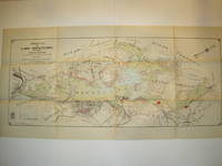
Property Map of Lake Hopatcong, New Jersey, Prepared by Hudson Maxim for the Morris Canal Investigation Commission, November 16, 1912, Compiled from Various Maps and Actual Surveys by P. E. Boomer, C. E.
by Maxim, Hudson; & P. E. Boomer
- Used
- Paperback
- first
- Condition
- Used - Near Fine condition
- Edition
- First Edition
- Binding
- Paperback
- Quantity Available
- 1
- Seller
-
Henderson, Nevada, United States
- Item Price
-
A$2,316.35
Show Details
Item Price
A$2,316.35

More Photos
富士見十三州輿地全圖. [Fujimi Jūsanshū yochi zenzu]. [Map of the Thirteen Provinces From Where Mt. Fuji Is Visible].
by AKIYAMA EINEN [OR NAGATOSHI] 秋山永年.
- Used
- Condition
- Used
- Edition
- [Reprint].
- Binding
- Unknown
- Quantity Available
- 1
- Seller
-
Canberra, Australian Capital Territory, Australia
- Item Price
-
A$2,500.00
Show Details
Description:
Shūseidō 衆星堂. [Reprint].. Tenpō 14 (1843).. Large folding handcoloured map of the thirteen provinces from which Mt. Fuji can be viewed. 159 x 178cm. Folds into paper covered card covers measuring 40 x 24cm. Title label upper cover. A little browning along folds, occasional spotting and soiling. A little worming causing approximately 1cm of loss in places. Two chops in lower section. A very striking and attractive map. This very large handsome map is a detailed map of the thirteen provinces from which one can see Mt. Fuji. Provinces shown are the eight provinces of the Kantō region, Sagami 相模, Musashi 武蔵, Kazusa 上総, Shimofusa 下総, Awa 安房, Kōzuke 上野, Shimotsuke 下野, and Hitachi, 常陸, and five other provinces, Izu 伊豆, Suruga 駿河, Tōtōmi 遠江, Kai 甲斐, and Shinano 信濃. The map…
Read More Item Price
A$2,500.00

More Photos
Le nouveau et curieux Atlas Geographique et historique...
by Chiquet (Jacques) [Antoine Menard].
- Used
- Hardcover
- Condition
- Used
- Binding
- Hardcover
- Quantity Available
- 1
- Seller
-
Sidney, British Columbia, Canada
- Item Price
-
A$3,486.15
Show Details
Description:
Paris: chez Chereanau, [1719].. Oblong small 4to. Full vellum with ties. Wear at edges, chip from fore-edge of lower front cover,blank end leaves are heavily annotated and written-upon in 18th & 19th century hands. Old stains to margins and a few maps, old paper-tape repairs to the verso of the Asia map, but generally very good. Engraved allegorical title page, 3 plates (two of globes), and 24 maps opposite explanatory text in French. 23 maps have contemporary hand-colouring in outline; a couple have attractively coloured cartouches. The Globe Terrestre map, of two hemispheres, is holed, slightly affecting the title. The map of North America shows California as an island. This is the second or third edition of this atlas, originally by Antoine Menard, first published by Chiquet in [1711 & 1713], with most of the maps dated 1709-1711. In this 1719 edition Chiquet has removed Menard's name entirely; on many of the maps (such as L'Amerique Septentrionale) he has changed it to his own name and altered…
Read More Item Price
A$3,486.15

More Photos
抗美援朝時事學習地圖. [Kang Mei yuan Chao shi shi xue xi di tu]. [Current Affairs Study Map - Resisting US Aggression and Aiding Korea].
by [YA XIN CARTOGRAPHIC STUDY SOCIETY].[亞新地學社].
- Used
- first
- Condition
- Used
- Edition
- 1st Edition.
- Binding
- Unknown
- Quantity Available
- 1
- Seller
-
Canberra, Australian Capital Territory, Australia
- Item Price
-
A$2,750.00
Show Details
Description:
武昌.[Wuchang].: 亞新地學社.[Ya xin di xue she].. 1st Edition.. August1951.. Large detailed colour Chinese map of Korean War, folded, scale 1:15,000,000, three inset maps on corners, illustrated legend showing agricultural and mining resources lower margin, in original envelope. Some light wear along edges, small holes and wear at folds mended with archival tape, envelope torn with loss mended with archival tape. Inset map 兩個陣營力量對比 "Strength Comparison Between The Two Camps" upper left corner, scale 1: 170,000,000. The Peaceful Camp in red covering the majority of Asia and Europe, a list of 6 countries (Germany, Czech, Hungary, Romania, Bulgaria, Albania) are numbered and are also part of the Peaceful Camp. The Invader Camp in grey covering North America and small parts of Europe, a list of 3 nations (Netherlands, Belgium, Luxembourg) are numbered and are also part of the Invader Camp. Block of text in…
Read More Item Price
A$2,750.00

More Photos
L’Utrecht suivant les nouvelles observations de Messrs. de l’Academie des Sciences etc. Augmentées de nouveau.
by Covens, Johannes et Cornelis Mortier
- Used
- Condition
- Used
- Quantity Available
- 1
- Seller
-
Tuebingen, Germany
- Item Price
-
A$3,735.00
Show Details
Description:
Engraved and partially hand-coloured map with nice figurative cartouche mounted on wood, backside lined with blue paste paper with impressed decoration (= complete). Oblong folio (300 x 223 mm). All pieces loosely contained in contemporary wooden box with a sliding lid with manuscript title "Utrecht" on top. A very early example of this kind of game, and hard to find complete and in very good overall condition.
Item Price
A$3,735.00

More Photos
Travels in the Interior Districts of Africa: Performed under the direction and patronage of the african association, in the years 1795, 1796, and 1797. with an appendix, containing illustrations of Africa by Major Rennel
by PARK, Mungo
- Used
- very good
- Hardcover
- Condition
- Used - Very Good
- Edition
- 2nd
- Binding
- Hardcover
- Quantity Available
- 1
- Seller
-
Cuernavaca, Mexico
- Item Price
-
A$2,463.55
Show Details
Description:
London, W.Bulmer and Co., 17994º. xxviii,(2),372 pp., xcii. Bound to style in a fine later calf. Title-and tomelabels with gilt lettering. Blindtoolings to bands and compartments of spine. Engraved portrait as frontispiece, 2 engraved plates with music, 5 engraved plates (of which 3 are views) and 3 large folded engraved maps. One map strenghtened in foldings and edges, one map with a closed tear to folding. Wide-margined, a few margins slightly brownspotted. Light offsetting to title and portrait.
Second edition - the same year as the first - of this classic work of travel litterature.
"Until the publicationof Park's book in 1799 hardly anything was known of the interior of Africa, apart from the north-east region and coastal areas....the real opening up of Africa by the white races began with the African Association, founded in 1788 with the express purpose of exploring Africa and furthering British tradee and political influence onthe continent...Parks travels had an immediate success and was… Read More
Item Price
A$2,463.55
More Photos
The Discovery of North America, A Critical, Documentary, and Historic Investigation,: with an essay on the early cartography of the New World, including descriptions of two hundred and fifty maps or globes existing or lost, constructed before the year 1536...
by Henry Harrisse
- Used
- very good
- Hardcover
- first
- Condition
- Used - Very Good
- Edition
- First Edition
- Binding
- Hardcover
- Quantity Available
- 1
- Seller
-
Fort Lauderdale, Florida, United States
- Item Price
-
A$2,246.63
Show Details
Description:
Quarter morocco over pictorial maroon cloth board with gilt particulars to spine. Top edge gilt. Limited edition copy No. 91 of 380 issued, this being the English Toned Paper edition. Hors textes plates with tissue guards throughout. Black and white illustrations throughout text as well. Title continued: "to which are added a chronology of one hundred voyages westward, projected, attempted, or accomplished between 1431 and 1504; biographical accounts of the three hundred pilots who first crossed the Atlantic; and a copious list of the original names of American regions, caciqueships, mountains, islands, capes, gulfs, rivers, towns, and harbours." Topics include: John Cabot, Gaspar Corte-Real, Christopher Columbus, Ancient Maps, First Knowledge of Florida, Colonisation [colonization] of Nova Scotia, Aliminos, Pardon Real, Lusitano-Germanic Cartography, and much more. Wear to head of spine and hinges, but still intact and sturdy. 802 pp. 9 3/4 x 11 3/4. A clean, bright volume without previous owners'…
Read More Item Price
A$2,246.63
![Lithograph Wall Chart] Structural Differential](https://d3525k1ryd2155.cloudfront.net/h/345/509/1338509345.0.m.jpg)
More Photos
Lithograph Wall Chart] Structural Differential
by Korzybski, Alfred (1879-1950)
- Used
- near fine
- first
- Condition
- Used - Near Fine
- Edition
- First Printing
- Quantity Available
- 1
- Seller
-
Bloomington, Indiana, United States
- Item Price
-
A$2,711.45
Show Details
Description:
New York: Rand McNally & Co. , 1949. RARE lithograph wall chart for the device called the "Structural Differential" which Alfred Korzybski patented in 1925 as a means to aid in visualizing the process he called "abstracting". This was to be used as a training device in general semantics, a field of study Korzybski is credited with founding. The chart is Near Fine, rubbed lower right, mounted on two stained wooden dowels with ribbon hanger 18" wide by 38" high. Korzybski's work in semantics heavily influenced science fiction authors such as A.E. Van Vogt, Robert A. Heinlein, Poul Anderson, and H. Beam Piper, as well as L. Ron Hubbard and Joseph W. Campbell. His most famous quote "The map is not the territory" comes from this longer quote "A map is not the territory it represents, but, if correct, it has a similar structure to the territory, which accounts for its usefulness."( Science and Sanity, Korzybski, 1931). OCLC locates no copies; no…
Read More Item Price
A$2,711.45

More Photos
Collection de cartes concernant les forêts, triages et bois taillés du Comté-prairie d'Eu
by ESTANCELIN, Louis
- Used
- near fine
- Hardcover
- first
- Condition
- Used - Near Fine
- Edition
- First
- Binding
- Hardcover
- Quantity Available
- 1
- Seller
-
COLUMBIA, Missouri, United States
- Item Price
-
A$2,324.10
Show Details
Description:
1768 Forests Eu Normandy France French Agronomy Rivers MAPS Atlas EstancelinLouis Estancelin, a 19th-century French politician, is best remembered for his book "Collection of Engravings on Forests and Woods in Eu" This work provides descriptions and views of forests, rivers, cities, and harbors in Eu, Normandy and their agronomic and economic implications in in pre-Revolutionary France.
Item number: #19556
Price: $1500
ESTANCELIN, Louis
Collection de cartes concernant les forêts, triages et bois taillés du Comté-prairie d'Eu
1768. 1st edition
Details:
·
Collation:
o
40 (plates)
o
Wanting #2, 3, 29, 32, 34, 35
· Language: French
· Binding: Leather; tight and secure
· Size: ~10.25in X 8.25in (26cm x 21cm)
· Exceedingly rare and desirable with auction records and price comparisons at upwards of $6,000
Our Guarantee:
Very Fast. Very Safe. Free Shipping Worldwide.
Customer satisfaction is our priority! Notify us with 7 days of receiving, and we will offer… Read More
Item Price
A$2,324.10

More Photos
Map of America
by Wyld, James Jr.
- Used
- Condition
- Used
- Quantity Available
- 1
- Seller
-
Port Hope, Ontario, Canada
- Item Price
-
A$457.07
Show Details
Description:
Copperplate engraved map with hand colouring. Chips to margins with minor losses, small closed tear upper left corner, a few light creases, small perforation to either side of centrefold (more visible on verso), verso c/f reinforced with tape but on the whole very good20-1/2" x 22-3/4"- 57.1 x 57.7 cm.
A detailed map of North America, the Caribbean, South America and the Pacific Islands. Alaska is still part of Russian possessions, and Texas stands as a Republic. James Wyld Jr. took over the family business in the mid 19th Century and continued to produce highly detailed maps of all regions of the world.
Item Price
A$457.07

More Photos
The Sky and the Forest
by Forester, C.S
- Used
- very good
- Hardcover
- first
- Condition
- Used - Very Good
- Jacket Condition
- Very Good
- Edition
- First Edition
- Binding
- Hardcover
- Quantity Available
- 1
- Seller
-
Salem, Oregon, United States
- Item Price
-
A$54.06A$32.43Save A$13.96!
Show Details
Description:
C.S. Forester: The Sky and the Forest. Little, Brown and Company, Boston. Stated First Edition First Printing Thus August, 1948. Cover price $2.75. Used. VG BOOK/VG UNCLIPPED DUST JACKET. A story of a central Africa. By C.S. Forester, author of the Admiral Hornblower series.
Item Price
A$54.06A$32.43
Save A$13.96
!
![Alaska and Klondike Region; [With inset of Klondike Region on the Upper Yukon detail] [From an...](https://d3525k1ryd2155.cloudfront.net/h/062/537/1339537062.0.m.jpg)
Alaska and Klondike Region; [With inset of Klondike Region on the Upper Yukon detail] [From an atlas, "Gazetteer of Alaska and Yukon Region " pp. 105 and 106]
by Miller, J. Martin
- Used
- very good
- Condition
- Used - Very Good
- Edition
- Unknown
- Quantity Available
- 1
- Seller
-
Sebastopol, California, United States
- Item Price
-
A$60.43
Show Details
Description:
Chicago: J. Martin Miller, 1899. Unknown. Map. Very Good. [Map copyright 1899, printing date of Atlas later] [19.875x15.125in]; Colored map of Alaska with steamer routes from Portland and Seattle, insets of the Klondike Region on the Upper Yukon and Western portion of Aleutian Islands; On verso index of places and names with two large black and white images; Age toning to all edges, water stain marks on bottom, slight printing offset of colors, small chips and closed tears to lower edge;.
Item Price
A$60.43

Zemepis Sveta - Monsunova Asie
by De La Blache, P. Vidal; Gallois, L
- Used
- Hardcover
- Condition
- Used - Very Good Condition
- Jacket Condition
- No Dust Jacket
- Binding
- Hardcover
- Quantity Available
- 1
- Seller
-
Oak Point, Texas, United States
- Item Price
-
A$92.96
Show Details
Description:
Aventinum, Prague, Czechoslovakia, 1931. Hardcover. Very Good Condition/No Dust Jacket. Text entirely in Czech. Geography book on Asia with numerous photographs and maps. 1930 edition also available. Size: 4mo - over 9 3/4" - 12" tall. 400 pp. Pages are yellowed, but are tight and clean. Moderate shelfwear along the spine. Corners are lightly bumped. Quantity Available: 1. Shipped Weight: 3-5 pounds. Category: Travel & Places; Non-English Language::Czech; Pictures of this item not already displayed here available upon request. Inventory No: 001228. . Additional shipping charges may apply.
Item Price
A$92.96

Zemepis Sveta - Monsunova Asie
by De La Blache, P. Vidal; Gallois, L
- Used
- Hardcover
- Condition
- Used - Very Good Condition
- Jacket Condition
- No Dust Jacket
- Binding
- Hardcover
- Quantity Available
- 1
- Seller
-
Oak Point, Texas, United States
- Item Price
-
A$92.96
Show Details
Description:
Aventinum, Prague, Czechoslovakia, 1930. Hardcover. Very Good Condition/No Dust Jacket. Text entirely in Czech. Geography book on Asia with numerous photographs and maps. 1931 edition also available. Size: 4mo - over 9 3/4" - 12" tall. 400 pp. Pages are yellowed, but are tight and clean. Moderate shelfwear along the spine. Corners are lightly bumped. Quantity Available: 1. Shipped Weight: 3-5 pounds. Category: Travel & Places; Non-English Language::Czech; Pictures of this item not already displayed here available upon request. Inventory No: 001227. . Additional shipping charges may apply.
Item Price
A$92.96

North America from the Best Authorities, Russell, ca.1800
by Russell
- Used
- Condition
- Used
- Quantity Available
- 1
- Seller
-
Plymouth, Devon, United Kingdom
- Item Price
-
A$38.76
Show Details
Description:
Russell, J. : A General Map of North America from the Best Authorities. Nd but ca.1800. From "A New Geographical, Historical and Commercial Grammar and Present State of Several Kingdoms of the World." Copper engraving. Size approx 200 x 230mm. Two neat folds. Some age colouring to edges, otherwise very clean and bright.
Item Price
A$38.76

Asia from the Best Authorities, Russell, ca.1800
by Russell
- Used
- Condition
- Used
- Quantity Available
- 1
- Seller
-
Plymouth, Devon, United Kingdom
- Item Price
-
A$38.76
Show Details
Description:
Russell, J. : Asia from the Best Authorities. Nd but ca.1800. From "A New Geographical, Historical and Commercial Grammar and Present State of Several Kingdoms of the World". Copper engraving. Size approx 200 x 230mm. Two neat folds. Some age colouring to edges, otherwise clean and bright. Includes Arabia, India, Borneo, Japan, China and eastern Russia.
Item Price
A$38.76
![MAP OF UTAH [Territory]](https://d3525k1ryd2155.cloudfront.net/h/836/461/1485461836.0.m.jpg)
More Photos
MAP OF UTAH [Territory]
- Used
- Condition
- Used - Very Good-
- Edition
- Original
- Quantity Available
- 1
- Seller
-
Williamsburg, Virginia, United States
- Item Price
-
A$100.71
Show Details
Description:
New York, Richmond, Chicago, & Toledo: H. H. Hardesty, 1885. Original color lithographed map printed by Rand, McNally & Company, Engravers and published in HARDESTY'S HISTORICAL AND GEOGRAPHICAL ENCYCLOPEDIA: SPECIAL VIRGINIA EDITION. 19 3/8 inches by 13 1/4 inches on a 21" X 14 1/2" sheet. The map depicts the Territory of Utah in its final form--large areas had been removed and ceded to Nevada, Colorado, Wyoming, and Nebraska since Utah became a U. S. Territory in 1850. The issue of polygamy prevented statehood until it was finally granted in 1896. This map features railroads and topography and uses color to set off counties from each other. Unlike most atlas maps of the period, this map identifies most small towns. The map is guaranteed to be moe than 135 years old. The map is in about very good condition: generally clean and bright, with slight toning of paper and one faint water stain near the center-left edge of the map.. Original. Single Sheet. Very Good-. Elephant…
Read More Item Price
A$100.71

Philips Special Map of the Nile, The Advance on Khartum and the Environs of Omdurman. Cc1900
by George Philips and Son,
- Used
- Condition
- Used
- Quantity Available
- 1
- Seller
-
Plymouth, Devon, United Kingdom
- Item Price
-
A$50.39
Show Details
Description:
Philips Special map of the Nile illustrating the Advance on Khartum [Khartoum] with an enlargement of the environs of Omdurman [Omdur]. George Philips and Son, London and Liverpool Ca 1900. 580mm x 900mm folded map. Front title wrapper has come loose, not affecting map area. Three maps are displayed within the sheet. Map1. Map of the Nile Valley 520mm x 300mm showing the approaches of Khartum. Scale 1inch to 100 Geographical miles. Coloured indicating Possessions and Protectorates of European Powers. Map 2. Special map of the Nile from Dongola to Khartum. Scale 16 miles to the inch. Coloured. In set in this map is Map3. Environs of Omdurman, Scale 5 statute miles to the inch. Some small breaks at some folds, not affecting imagery or use of map. Title label is damaged, the map is clean and bright, probably unused. A very interesting record.
Item Price
A$50.39

Last Tales
by Dinesen, Isak
- Used
- very good
- Hardcover
- first
- Condition
- Used - Very Good
- Jacket Condition
- Good+
- Edition
- First Edition
- Binding
- Hardcover
- Quantity Available
- 1
- Seller
-
Salem, Oregon, United States
- Item Price
-
A$185.93A$111.56Save A$48.00!
Show Details
Description:
Dinesen, Isak: Last Tales, A Collection of Twelve New Tales of Compelling Beauty 1957, Random House. First Edition. Stated First Printing Thus. Used. Very Good/Good+ original red dust jacket, price-clipped. Jacket states 11/57 on front flap. 5 3/4 X
Item Price
A$185.93A$111.56
Save A$48.00
!

The Adventure of Wrangel Island
by Vilhjalmur Stefansson
- Used
- good
- Hardcover
- first
- Condition
- Used - Good
- Jacket Condition
- No DJ Included
- Edition
- First Edition
- Binding
- Hardcover
- Quantity Available
- 1
- Seller
-
Salem, Oregon, United States
- Item Price
-
A$193.50A$116.10Save A$49.96!
Show Details
Description:
The Adventure of Wrangel Island, Alaska (1925 Macmillan 1st Edition) HISTORY OF ALASKA. EXLIB. Good Condition/ No DJ included. Fold-out map affixed to binding at the back of the book has never been opened. The story of the (unsuccessful) attempted colonization of Wrangel Island Alaska. 413 pages plus appendix, Index. Titling is still bright. A clean, solid copy. Scarce.
Item Price
A$193.50A$116.10
Save A$49.96
!
