BIBLIO is the largest independent book marketplace in the world, with over 100 million books.

Skip to content

A Topographical Map of the County of Middlesex.

A Topographical Map of the County of Middlesex.

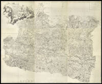
A Topographical Map of the County of Middlesex.: Rocque's fine separately issued map of Middlesex 1754

by ROCQUE, John

Add to wish list
  • Used

Description

London,, 1754.. 975 by 1410mm. (38.5 by 55.5 inches).. Large engraved map with fine original handcolour, dissected and mounted on linen, housed within original calf slipcase, defective. Rocque's finely engraved map of Middlesex. The map extends from Staines in the west to Leytonstone and from Harefield in the north to Kingston-upon-Thames in the south. To the upper centre is a fine title cartouche with depictions of a Georgian surveyor holding a waywiser, and a putti using a plane. The text to the upper right gives details on the extent of the county, together with the extent of London, which is said to be 6 and a half miles in length, 2 and a half in breadth, has a circumference of 8 and a half miles or 5455 acres. It would appear that John Rocque, a French Huguenot, emigrated with the rest of his family to London in the 1730s, where he began to ply his trade as a surveyor of gentleman's estates, and with plans of Kensington Gardens, and Hampton Court. However, in 1737 he applied his surveying skills to a much greater task, that of surveying the entire built-up area of London - a survey that would make his name. Begun in March of 1737, the map would take nine years to produce, eventually being engraved upon 24 sheets of copper and published in 1746. BL Cartographic Items Maps 3455 (1).
Add to wish list
This copy is no longer for sale. Please see below for alternate copies of this title, if available. You can also add this book to your want list and we will notify you when we locate other copies:

Details

  • Title A Topographical Map of the County of Middlesex.
  • Author ROCQUE, John
  • Publication date 1754.
  • Bookseller's Inventory # 13037
  • Size 975 by 1410mm. (38.5 by 55.5 inc
  • Quantity available 1

More Copies for Sale

A Topographical Map of the County of Surrey

Show details

Description:
London,: Mary Ann Rocque,, [c1787].. 570 by 700mm. (22.5 by 27.5 inches).. Large oblong folio (580 by 720mm), large engraved map on nine sheets, bound in plano, six sheets remargined at right, with no loss to image, green half calf over original eighteenth century marbled paper boards, rebacked and recornered, red morroco label lettered in gilt to upper board. The second state of John Rocque's immensely detailed map of Surrey, identifiable by the inclusion of the Battersea and Richmond Bridges. Richmond Bridge was completed in 1787, the probable date of this work. The contribution of the Huguenot surveyor and engraver John Rocque (d.1762) to English regional cartography is difficult to overstate. He produced fine surveys of Berkshire, Middlesex, Shropshire and Surrey, together with two important maps of London. The Surrey map is no exception - the first of the county on this scale. Following Rocque's death in 1762 the survey was completed and the plates engraved by Peter Andrews, but it retains… Read more
Add to wish list
Item price
A$8,557.20
A$28.52 Delivery to USA
(BERKSHIRE). A Topographical Survey of the County of Berks in Eighteen Sheets...[with] A Map of...

Show details

Description:
London: Published according to Act of Parliament by John Rocque Chrographer to his Majesty [and] Mary Anne Rocque, 1761 and 1762 respectively.. Original hand-coloured map engraved by Richard Benning and L.F. Deharme (dated 1761) on 18 sheets folio (4 single page 53 x 40 cm. and 14 double page 53 x 76 cm, complete. If joined would measure 1625 x 2730 cm), plus the key map entitled "... Map of the County of Berks reduced from the Actual Survey in 18 Sheets" (published by Mary Anne Rocque and dated 1762, also with original hand-colour). Nineteenth century half burgundy morocco over brown cloth. The large map complete but the whole work bound without the printed title or the 12 page index. Repair in outer margin of first leaf (engraved dedication, plate 15 of the whole map) and minor marginal dampstain, similarly plate one of the map, corner crease to general map, the remainder generally very fresh and clean. An uncommon map and rare in original colour, including the additional reduced key map.
Add to wish list
Item price
A$12,835.80
A$17.02 Delivery to USA