Antiquarian Map-Africa from Webster's Fine Books & Maps, ABAC, ILAB
New Arrivals

Egypt
by Wyld, James [Stockley, S]
- Condition
- Used - Left margin a little ragged else fine.
- Published
- c. 1864
- Binding
- Steelplate engraving with hand colouring
- Quantity Available
- 1
- Seller
-
Port Hope, Ontario, CAN
- Item Price
-
A$84.23
Show Details
Description:
A detailed map of Egypt showing deserts, oases, The Red and Mediterranean seas and the Nile River. Also shows parts of Arabia, Palestine and Syria.
Item Price
A$84.23

GUINEAE NOVA DESCRIPTIO
by Hondius, Jodocus
- Condition
- Used - Old colour, some darkening along c/f otherwise very good.
- Published
- c. 1633
- Quantity Available
- 1
- Seller
-
Port Hope, Ontario, CAN
- Item Price
-
A$995.48
Show Details
Description:
A very good map of Western Africa from Senegal to Cape Lopez .Inset map of the Island of S. Tomas an important slave trading outpost for those waiting to be transported to the new world.
Van der Krogt 1, 8700:1A.
Item Price
A$995.48
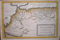
MAVRETANIA, NVMIDIA, GAETVLIA &C.
by Basire, Isaac
- Condition
- Used - Very good dark impression
- Published
- c. 1748
- Binding
- Copperplate engraving with hand colouring
- Quantity Available
- 1
- Seller
-
Port Hope, Ontario, CAN
- Item Price
-
A$99.55
Show Details
Description:
A very good map of northwestern Africa, including Mauretania, Numidia, and southern Algeria . Shows towns, ports and the Atlas mountains.
Item Price
A$99.55
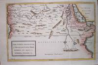
LIBYA INTERIOR, GARAMANTUM ET MELANOGAETVLORVM REGIO, AETHIOPIA SVB AEGYPTO, AETHIOPIA INTERIOR &C.
by Basire, Isaac
- Condition
- Used - Very good dark impression
- Published
- c. 1748
- Binding
- Copperplate engraving with hand colouring
- Quantity Available
- 1
- Seller
-
Port Hope, Ontario, CAN
- Item Price
-
A$130.18
Show Details
Description:
A very good map of Libya, Egypt, Ethiopia and the Arabian Sea. Towns, ports, seas and the Nile River are shown.
Item Price
A$130.18

ALGIERS AND PARTS ADJACENT
by Anon
- Condition
- Used - Light browning, light crease upper left corner but overall very good.
- Published
- 1749.
- Quantity Available
- 1
- Seller
-
Port Hope, Ontario, CAN
- Item Price
-
A$191.44
Show Details
Description:
London: , 1749.. Light browning, light crease upper left corner but overall very good.. 7-3/4" x 4"- 19.6 x 10.1 cm. . Jolly GENT-68 A charming map of the Bay of Algiers, Algiers and the environs. Several castles, villages and two large native birds the Boo-ank and the Hou-baara. Item Price
A$191.44

AFRICA FROM THE LATEST AUTHORITIES
by Barlow, John
- Condition
- Used - Margins chipped with losses else very good.
- Published
- 1816.
- Quantity Available
- 1
- Seller
-
Port Hope, Ontario, CAN
- Item Price
-
A$145.49
Show Details
Description:
Suffolk:, 1816.. Margins chipped with losses else very good. . 7-1/4" x 8"-18.4 x 20.3 cm.. A detailed map of the African continent. Gold mines, mountains, rivers and towns are depicted. Item Price
A$145.49

A MAP OF THE EMPIRE OF MOROCCO COMPREHENDING THE KINGDOMS OF FEX, MOROCCO, &C
by Kitchin, Thomas
- Condition
- Used - Light browning but overall very good.
- Published
- 1760.
- Quantity Available
- 1
- Seller
-
Port Hope, Ontario, CAN
- Item Price
-
A$145.49
Show Details
Description:
1760.. Light browning but overall very good.. 4-1/4" x 6-3/4"- 10.7 x 17.1 cm. . London: London Magazine, A hand coloured copper engraved map. Jolly LOND-181 A good 18th century map of the kingdoms of Fez, Algiers, Segelmese, Tafilet and Morocco. Towns, rivers and mountains are indicated. Map, Morocco, North Africa, Gibraltar, Fez, Algiers, London Magazine Item Price
A$145.49

BAY OF TUNIS
by Mount, William & Page, Thomas
- Condition
- Used
- Published
- 1776
- Quantity Available
- 1
- Seller
-
Port Hope, Ontario, CAN
- Item Price
-
A$191.44
Show Details
Description:
London: : From Thornton's "The English Pilot Part III....The Whole Mediterranean Sea" Mount and Page,, 1776. Image size 5" x 9"- 12.4 x 22.8 cm. on sheet measuring 18-1/4" x 11-1/2"- 46.3 x 29.2 cm. Copper engraved map hand coloured in outline. Very good. A very good chart showing the harbour of Tunis with soundings, islands and compass rose. Verso… Read more about this item Item Price
A$191.44
COSTE OCCIDENTALE D'AFRIQUE DEPUIS LE DETROIT DE GIBRALTAR JUSQU'AU XIE DEGRE DE LATITUDE SEPTENTRIONALE. TIREE DE LA CARTE FRANCOISE DE L'OCEAN ORIENTAL
by Bellin, Jacques Nicolas
- Condition
- Used
- Published
- 1749
- Quantity Available
- 1
- Seller
-
Port Hope, Ontario, CAN
- Item Price
-
A$229.73
Show Details
Description:
From "Histoire Generale des Voyages": Paris, , 1749. 9-1/2" x 7-1/2"- 24.1 x x 19 cm. Copper engraved map hand coloured in outline. A couple of extra creases, else very good. A detailed map of the western coast of Africa from the Straits of Gibraltar to Gambia. The Cape Verde Islands, the Canary Islands and Madera are indicated. Item Price
A$229.73

CARTE DE TOUTES LES ISLES CONNUES A LA COSTE DE ZANGUEBAR ET MADAGASCAR QUE L'ON TROUVE DANS LA ROUTE DE L'INDE
by Bellin, Jacques Nicolas
- Condition
- Used
- Published
- 1749
- Quantity Available
- 1
- Seller
-
Port Hope, Ontario, CAN
- Item Price
-
A$199.10
Show Details
Description:
From "Histoire Generale des Voyages": Paris, , 1749. 9" x 10-3/4"- 22.8 x 27.3 cm. Copper engraved map hand coloured in outline. Small closed tear left margin, toned overall generally very good. A detailed coastal map of the east coast of Africa including the island of Madagascar and the islands in the Indian Ocean. Item Price
A$199.10

CARTE DE LA COSTE ORIENTALE D'AFRIQUE DEPUIS LE XIIE DEGRE DE LATITUDE MERIDIONALE JUSQ'AU XVIE DEGRE DE LATITUDE SEPTENTRIONALE
by Bellin, Jacques Nicolas
- Condition
- Used
- Published
- 1749
- Quantity Available
- 1
- Seller
-
Port Hope, Ontario, CAN
- Item Price
-
A$168.46
Show Details
Description:
From "Histoire Generale des Voyages": Paris, , 1749. 9-1/2" x 7-1/2"- 24.1 x 19 cm. Copper engraved map hand coloured in outline. Small closed tear left margin, some offsetting yet still generally very good. A detailed coastal map of the east coast of Africa after the Count of Maurepas' map in 1740. Item Price
A$168.46

THE SEA COAST OF BARBARY FROM CAPE DE TENES TO CAPE DE ROSA
by Mount, William & Page, Thomas
- Condition
- Used
- Published
- 1776
- Quantity Available
- 1
- Seller
-
Port Hope, Ontario, CAN
- Item Price
-
A$306.30
Show Details
Description:
London: : Mount and Page,, 1776. 15" x 19"- 38.1x 48.2 cm. Copper engraved map. Offsetting else very good. A very good sea chart engraved by James Bennet showing the Barbary coast with an inset view of the harbour near Agrier. Item Price
A$306.30

COSTE OCCIDENTALE D'AFRIQUE DEPUIS LE XIE DEGRE DE LATITUDE MERIDIONALE JUSQU'AU CAP DE BONNE ESPERANCE. TIREE DE LA CARTE FRANCOISE DE L'OCEAN MERIDIONAL
by Bellin, Jacques Nicolas
- Condition
- Used
- Published
- 1749
- Quantity Available
- 1
- Seller
-
Port Hope, Ontario, CAN
- Item Price
-
A$183.78
Show Details
Description:
From "Histoire Generale des Voyages": Paris, , 1749. 9-1/2" x 10-1/4"- 24.1 x x 26 cm. Copper engraved map hand coloured in outline. A couple of brown spots lower neatline, else very good. A good map from the Benguela coast of west Africa to the Cape of Good Hope. Item Price
A$183.78
CARTE DE LA COSTE OCCIDENTALE D'AFRIQUE DEPUIS LE XIIE DEGRE DE LATITUDE SEPTENTRIONALE JUSQU'AU XIe DEGRE LE LATITUDE MERIDIONALE
by Bellin, Jacques Nicolas
- Condition
- Used
- Published
- 1749
- Quantity Available
- 1
- Seller
-
Port Hope, Ontario, CAN
- Item Price
-
A$191.44
Show Details
Description:
From "Histoire Generale des Voyages": Paris, , 1749. 7-3/4" x 9-1/2"- 19.6 x 24.1 cm. Copper engraved map hand coloured in outline. Light offsetting, else very good. A map of the west coast of Africa from Cacheo in Sierre Leon to Cap. Ledo in Angola. Includes the Ivory Coast, Benin, Biafra, Maiumbo, Loango and the Congo. English, Dutch… Read more about this item Item Price
A$191.44
CARTE DE LA COSTE ORIENTALE D'AFRIQUE DEPUIS LE CAP DE BONNE ESPERANCE JUSQU'AU CAP DEL GADA TIREE DE LA CARTE FRANCOISE DE L'OCEAN ORIENTAL
by Bellin, Jacques Nicolas
- Condition
- Used
- Published
- 1749
- Quantity Available
- 1
- Seller
-
Port Hope, Ontario, CAN
- Item Price
-
A$229.73
Show Details
Description:
From "Histoire Generale des Voyages": Paris, , 1749. 9-1/2" x 8-3/4"- 24.1 x 22.2 cm. Copper engraved map hand coloured in outline. Left margin trimmed close as issued, else very good. A detailed map of the eastern coast of Africa from the Zanzibar coast to the Cape of Good Hope. Item Price
A$229.73
CARTE EXACTE DE LA COTE DU CAP VERD
by Bellin, Jacques Nicolas
- Condition
- Used
- Published
- 1749
- Quantity Available
- 1
- Seller
-
Port Hope, Ontario, CAN
- Item Price
-
A$122.52
Show Details
Description:
From "Histoire Generale des Voyages": Paris, , 1749. 8-1/4" x 5-1/2"- 20.9 x 13.9 cm. Copper engraved map hand coloured in outline. Left margin trimmed close as issued, else very good. A map of the coast of Cape Verd showing where Barbot sailed and showing below views of Cape Emanuel and the Island of Goree. Item Price
A$122.52
MAP OF AFRICA, SHOWING ITS MOST RECENT DISCOVERIES. 1860
by Mitchell, Samuel Augustus
- Condition
- Used
- Published
- 1863
- Quantity Available
- 1
- Seller
-
Port Hope, Ontario, CAN
- Item Price
-
A$153.15
Show Details
Description:
Philadelphia: : S. Augustus Mitchell, , 1863. 10-3/4" x 13-1/2"- 27.3 x 34.2 cm. Lithograph with original hand colouring. Minor browning and chipping o margins, else very good. A detailed and decorative map of Africa including parts of Arabia and Persia, with scrolling foliate border. Inset map of the Island of St. Helena in the Atlantic Ocean. Shows… Read more about this item Item Price
A$153.15

A CHART OF YE COAST OF BIAFRA FROM FOCHE ISLAND TO CORSICO ISLAND TOGETHER WITH THE ISLANDS OF FERNANDO POO & PRINCES
by Mount, William, Page, Thomas
- Condition
- Used
- Published
- 1761
- Quantity Available
- 1
- Seller
-
Port Hope, Ontario, CAN
- Item Price
-
A$137.84
Show Details
Description:
London: : From "The English Pilot: Part V" Sixth edition. Mount and Page, , 1761. 6-3/4" x 20-1/2"-42.5 x 52 cm. Copper engraved map. Light overall browning with darker areas to corners, some separation of paper to lower left corner, losses to lower left and right corners extending past neatlines, generally fair. A coastal chart engraved by Francis Lamb with… Read more about this item Item Price
A$137.84
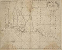
A CHART OF YE COAST OF ANGOLA FROM YE R. AMBRIS TO MOUNT NEGRO
by Mount, William, Page, Thomas
- Condition
- Used
- Published
- 1761
- Quantity Available
- 1
- Seller
-
Port Hope, Ontario, CAN
- Item Price
-
A$229.73
Show Details
Description:
London: : From "The English Pilot: Part V" Sixth edition. Mount and Page, , 1761. 16-3/4" x 20-1/2"- 42.5 x 52 cm. Copper engraved map with hand colouring. Light overall browning with darker areas to corners, generally good . An interesting coastal chart engraved by Francis Lamb showing rhumb lines, from the Congo to Mount Negro in Mataman (now Namibia). Item Price
A$229.73

A CHART OF YE COASTS OF GABON, LOANGO, AND CONGO FROM C. ST. IOHN TO THE RIVER AMBRIS
by Mount, William, Page, Thomas
- Condition
- Used
- Published
- 1761
- Quantity Available
- 1
- Seller
-
Port Hope, Ontario, CAN
- Item Price
-
A$214.41
Show Details
Description:
London: : From "The English Pilot: Part V" Sixth edition. Mount and Page, , 1761. 16-3/4" x 20-1/2"- 42.5 x 52 cm. Copper engraved map. Light overall browning with darker areas to corners, 2-1/2" loss to upper right margin just extending past neatline, generally good. A good coastal chart engraved by Francis Lamb with rhumb lines, from Gabon to the… Read more about this item Item Price
A$214.41
