The American Household and Commercial Atlas of the World
- Used
- Hardcover
- Signed
- Condition
- See description
- Seller
-
Garrison, New York, United States
Payment Methods Accepted
About This Item
New York: Taintor Brothers & Co, 1874. Hardcover. Important and scarce post Civil War atlas of the US, during the presidency of Ulysses S. Grant, the map of North America showing "United States Alaska Territory" (purchased in 1867) and the transcontinental railroad (completed in 1869).
With Plate XXXII showing Texas with all the settled counties, and Indian Territory just to the north, Arizona and New Mexico to the west. Plate XXXIV with all the western states shown, from Dakota west to Washington and down to Nevada.
Wyoming is shown with the newly formed Yellowstone National Park (established by Congress and signed into law by US Grant in 1872) within a ruled rectangular border and the transcontinental railroad and Bozeman Pass to the north of the Park. Also shows Colorado prior to its 1876 admission as the 38th state.
Double page map of Florida with an inset of the Florida keys, indicating the southern portion of the mainland as Indian Hunting Ground. Incredible network of waterways are also indicated in this area.
The 'Map of Oceanica (sic)' (LIII & LIV) shows the west coast of the United States down to Australia, Malaysia and Polynesia, with the sea routes from San Francisco to the Sandwich Islands, and continuing on to Sydney, Hobart and Perth. Showing the Queensland border going straight across, continuous with the southern border of South Australia, with Brisbane left in New South Wales. This border was determined in 1862. The ocean colored with a pale wash.
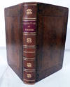
Elephant folio, [iv] preliminary leaves, 38 color maps on 54 leaves, 55-60 pages, 1-42 pages. Includes an "Index to post offices in the United States" (pp 1-42) which follows p. 60. Each state with the counties in different colors, the borders in red. Half brown leather and green gilt cloth. Spine a bit chipped at edges, corners bumped, cloth at front board below decorative gilt title is marked, small perforation in cloth surrounded by area of discoloration. Internally, the maps in very good condition.
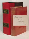
With an elaborately lettered inscription at the ffep, "Purchased at auction of T. C. Simpson, MD, Nov. 11 1908", with a presentation inscription below, by Krook, from West Fairlee, Vermont. OCLC: 81774194 records one copy, at the Huntington Library. Trove 50081467.
Reviews
(Log in or Create an Account first!)
Details
- Bookseller
- Antipodean Books, Maps & Prints
(US)
- Bookseller's Inventory #
- 22344
- Title
- The American Household and Commercial Atlas of the World
- Format/Binding
- Hardcover
- Book Condition
- Used
- Quantity Available
- 1
- Publisher
- Taintor Brothers & Co
- Place of Publication
- New York
- Date Published
- 1874
- Bookseller catalogs
- MAPS; NEW ZEALAND; CALIFORNIA; AUSTRALIA;
Terms of Sale
Antipodean Books, Maps & Prints
30 day return guarantee, with full refund including shipping costs for up to 10 days after delivery if an item arrives mis-described or damaged.
About the Seller
Antipodean Books, Maps & Prints
Biblio member since 2009
Garrison, New York
About Antipodean Books, Maps & Prints
Booksellers for over 40 years, members of prominent trade associations (ABAA, ILAB, ANZAAB, IMCOS, ANZMS, PBFA). We are located at Garrison NY, a stone's throw from the Metro North Hudson line train, just over 1 hr. from NYC on the banks of the Hudson River. Books, maps, prints & ephemera bought & sold.
Glossary
Some terminology that may be used in this description includes:
- FFEP
- A common abbreviation for Front Free End Paper. Generally, it is the first page of a book and is part of a single sheet that...
- Gilt
- The decorative application of gold or gold coloring to a portion of a book on the spine, edges of the text block, or an inlay in...
- Cloth
- "Cloth-bound" generally refers to a hardcover book with cloth covering the outside of the book covers. The cloth is stretched...
- Plate
- Full page illustration or photograph. Plates are printed separately from the text of the book, and bound in at production. I.e.,...
- Spine
- The outer portion of a book which covers the actual binding. The spine usually faces outward when a book is placed on a shelf....
- Leaves
- Very generally, "leaves" refers to the pages of a book, as in the common phrase, "loose-leaf pages." A leaf is a single sheet...
- Edges
- The collective of the top, fore and bottom edges of the text block of the book, being that part of the edges of the pages of a...
- Folio
- A folio usually indicates a large book size of 15" in height or larger when used in the context of a book description. Further,...


