Click for full-size.

The Jarrold Map of the Broads: What to Do on the Norfolk Broads
by Freda (drawn by) Hands
- Used
- Paperback
- first
- Condition
- Very Good Condition/n/a
- Seller
-
Cambridge, Cambridgeshire, United Kingdom
Payment Methods Accepted
About This Item
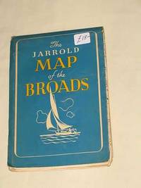
Jarrold & Sons Ltd, Norwich, 1946. First Edition. Softcover. Very Good Condition/n/a. Map contains all the information required when sailing or cruising on the Broads - tide tables, moorings, etc. The 200 miles of navigable waterways known as the Rivers and Broads of Norfolk and Suffolk are unique in the British Isles for their varied scenery, sailing and cruising and outdoor sports, historical and antiquarian interest, coarse fishing, and the profusion of other wild life. This map has been specially drawn to supply all the information necessary for the full enjoyment of a holiday in Broadland. The map is divided into four sections, the key to which and to items of topography is to be found in the top left-hand corner. The Bure, with its tributaries the Ant and the Thurne - together with their respective broads - is covered by sections A, B and C, whilst the Yare and the Waveney are dealt with in section D. By matching the coloured lines printed at the edge of the sections, the course of the rivers can easily be traced from section to section. Navigable water is coloured dark blue while light blue denotes private, unnavigable or otherwise inaccessible water. The navigable channels through the Broads are also indicated by dark blue; in crossing these shallow broads, such as Hickling or Breydon Water, it is necessary to keep between the posts marking the channel. Broadland is rich in fine churches, villages and sites of antiquarian interest. These are clearly shown on the map which also indicates Inns, Hotels and Post Offices. The map will also be useful to tourists and ramblers, since it shows so clearly the roads and footpaths of broadland. The fact that a road or footpath exists on the map must, however, not be taken as evidence that a right of way also exists. n/a.. Item Type: Map. Quantity Available: 1. Shipped Weight: Under 250 grams. Category: Geography & Maps; East Anglia; Norfolk; Suffolk; England; Reference. Inventory No: 4699. .
Reviews
(Log in or Create an Account first!)
Details
- Bookseller
- Bookbarrow
 (GB)
(GB)
- Bookseller's Inventory #
- 4699
- Title
- The Jarrold Map of the Broads: What to Do on the Norfolk Broads
- Author
- Freda (drawn by) Hands
- Format/Binding
- Softcover
- Book Condition
- Used - Very Good Condition
- Jacket Condition
- n/a
- Quantity Available
- 1
- Edition
- First Edition
- Binding
- Paperback
- Publisher
- Jarrold & Sons Ltd
- Place of Publication
- Norwich
- Date Published
- 1946
- Keywords
- BZDB227 Maps/Charts/Reference/The Broads/East Anglia/Norfolk/Suffolk Geography & Maps; East Anglia; Norfolk; Suffolk; England; Reference. Unbranded Freda (drawn by) Hands The Jarrold Map of the Broads: What to Do on the Norfolk Broads
Terms of Sale
Bookbarrow
30 day return guarantee, with full refund including original shipping costs for up to 30 days after delivery if an item arrives misdescribed or damaged.
About the Seller
Bookbarrow
Biblio member since 2014
Cambridge, Cambridgeshire
About Bookbarrow
Private Premises by appointment only and various book fairs (see websites of "P.B.F.A." and "Missing Books" for details).
Glossary
Some terminology that may be used in this description includes:
- Fine
- A book in fine condition exhibits no flaws. A fine condition book closely approaches As New condition, but may lack the...
- First Edition
- In book collecting, the first edition is the earliest published form of a book. A book may have more than one first edition in...
Frequently asked questions
This Book’s Categories

Collecting food and drink books
Nothing quite whets the appetite for rare and collectible books like old and vintage cookbooks. Be sure to check out our cook books and food section of our rare book room.

How to tell if a signature is genuine
Author's signatures can undoubtedly increase the value of a rare book or first edition. The more scarce the book is, the more an autograph adds to its value. But how to tell if the signature is real? Find out how you can avoid common pitfalls in identifying an author's signature.
