
Click for full-size.
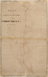
PLAN OF THE LANDS & WATER OF THE PARKER MILLS CO. in Wareham, Mass. - Manuscript (nd) (c. 1834?)
by Sylvanus Bourne
- Used
- Condition
- See description
- Seller
-
FRAMINGHAM, Massachusetts, United States
Payment Methods Accepted
About This Item
Details:
S[ylvanus]. Bourne, Surveyor
manuscript survey map, hand inked, with partial water color, a working map with some ink overwriting in a different hand
dimensions: 36 ¾" x 23 1/8"
condition: original inks and water colors, cleaned, professionally conserved, original fabric backing removed, area of loss due to a hungry mouse filled, other paper loss filled, unbacked.
Description:
This undated manuscript Plan of the Lands & Water of the Parker Mills Co. in Wareham, Mass. c. 1834? is a rare, new discovery that offers a detailed view of Wareham in its early industrial period. The scope of the Plan of the Lands and Water of the Parker Mills Co. (the "Plan") is defined by the geographic scope of the property of one of Wareham's major iron and nail manufacturers, the Parker Mills Co., whose business history begins in the 1830's, and predate its 1845 legal incorporation by Act of the Massachusetts Legislature. The predecessor to the Parker Mills Co. was the Wareham Iron Co. (Tihonet Pond Upper Works and Parker Mill and Pond Lower Works), whose business and assets were purchased around 1834 by some of its former stockholders, including John Parker who had managed the Tihonet Upper Works. The purchased assets included the large iron and nail factories shown on the Plan as the Tihonet Pond & Works, and Parker Mill and Parker Pond, two canals each labeled "canal", the locks at Wareham Narrows represented graphically, certain land, likely water rights and certain other business property in Wareham and adjoining towns totaling 3,903 acres. 1/ The Plan includes small inset plans of company owned, undeveloped land in Middleborough, Plymouth and Rochester and a parcel in Agawam, then part of Wareham. The Wankinco River is identified as is the Frog Foot Branch, and the Roberts River while other water bodies are not labeled. The boundary between the town of Wareham and adjoining Carver and Plymouth is labeled. There is no north arrow. There is no scale indicated on the Plan. The surveyor has drawn town buildings on the Plan in an early 19th c. "folk art" survey style, presenting a kind of bird's eye view of homes with doors and windows, meeting houses, churches identified with a steeple and small cross, larger buildings that likely are schools, inns or small factories. 2/ Trees are drawn in dense groups to indicate forest. Other water bodies, such as ponds, inlets and points are outlined but not labeled. Roads are shown but not labeled. On the reverse, written in black ink on the linen is an undated note: "Bridgewater Iron Co.'s Parker Mills Property".
Wareham entered the early industrial era with the 1822 introduction of the nail making machine by L & J. Pratt, followed by the 1828 construction of the Tihonet Pond and Works to make iron nails and other industrial iron products and further industrial expansion at this site by the Wareham Iron Works Co. These Wareham iron factories were among the nation's largest and produced nails that were shipped from Wareham to the entire United States by large vessels that had access to the Upper (Tihonet) Wareham Iron Works factories through a set of transportation canals and locks connecting to the Wareham Narrows and Buzzards Bay, as shown on the Plan. The Wareham Bank opened in 1833 reflecting the need for a financial institution. At this date there was no railroad in Wareham. A "rail-road" was incorporated in 1846, by Parker, Bourne and others, that reached Wareham around 1848 and ran past these nail factories en route to Cape Cod.
The surveyor who surveyed the Parker Mill properties and drew the Plan is Sylvanus Bourne (1797 to 1861), whose family had deep roots in Wareham from its first settlement and 1739 founding as a town. Sylvanus Bourne was a surveyor, local railroad investor 3/ and a historian of Wareham 4/. Bourne is the author of the only published map of Wareham in this early 19th c. era, the Map of Wareham Surveyed and Drawn by S. Bourne in 1832. (the "1832 Map") published by Pendleton's Lithography in Boston. Bourne's undated Plan and his 1832 Map may be the only extant early 19th c. surveys and mapping of Wareham. 5/
The Plan is a new discovery that provides a rare graphic view of Wareham's early industrialization. Bourne's Plan shows at a larger scale than the 1832 Map the major factory sites and their surroundings, local homes and town buildings. Both of these Bourne surveys show rapid industrial growth that followed two key events, Wareham's geographic enlargement through annexation in 1827 of Tihonet, a northerly manufacturing village, from Plymouth and Carver; and in 1828, building of a mill dam to form Tihonet Pond and power the Tihonet Works along with two transportation canals with a locks to the south on the Tihonet River to allow ship access to and from Buzzards Bay. Assigning a date to the Sylvanus Bourne undated Plan relies on analysis of several sources, and may be only possible within a date range: Sylvanus Bourne's published historical narrative, certain Massachusetts Historic Commission reports and other Wareham histories.6/ This Plan is of more than academic interest. The Plan provides unique documentation regarding ownership of the Parker iron mills and related mill structures such as dams, canals and bridges and possibly rights in labeled waterways. As of 2018, the Town of Wareham has sought such ownership information to determine responsibility for repairs to certain surviving Parker Mill structures. 7/
Based on preliminary research, the Plan may be dated in the period 1832 and before 1836. The outlying date of the Plan could be 1845. A comparison of the Plan and the 1832 Map provide some clues. Historical record provides others, but inconsistencies make a date certain difficult to establish.
First, Sylvanus Bourne himself relates that a Methodist Society was formed in 1830, and soon thereafter the Society built a church near the town center.8/ It is difficult to determine if this Methodist Church is shown "near the town center" on his Plan. The much older Congregational Church at the distinctive Wareham town center is drawn on the Plan with a symbolic church steeple topped with a cross and other churches are located elsewhere outside the immediate town center. At a nearby fork of two roads north of the town center, the Plan shows no structures of any kind. By contrast, Bourne's 1832 Map locates and labels the Congregational Church at the Town center, and locates and labels the Methodist Church with a cemetery at this same fork north of the town center. The 1832 Map locates and labels a Baptist Church south of the Town center, as does the Plan. This comparison suggests the Plan predates the 1832 Map.
Second, until approximately 1832 or shortly thereafter 9/, a unique ferry crossing of the Wareham Narrows was the only means of crossing the Wankinco River. Bourne's 1832 Map shows a "Ferry" at the Wareham Narrows. By contrast, the Plan shows a bridge crossing the Wareham Narrows and a new road on the eastern point. The absence of a ferry and the presence of the bridge therefore dates the Plan after the 1832 Map without dating it precisely. However, certain roads shown on the Plan are not shown on the Map and vice versa making dating based on the presence of roads difficult. Finally, to help establish a "before and not after" date for the Plan, we learn from Bourne in his history of Wareham that the Agawam works were built in 1836. On the Plan, the inset plan of the Agawam lot is undeveloped suggesting therefore that his survey work for the Plan was completed prior to the siting and construction of the Agawam works, thus prior to 1836.
Precise dating of the Plan may only be possible from access to Sylvanus Bourne's own survey notes, if any exist. We can assume that Bourne's survey work for and drawing of the 1832 Map took considerable time in 1830-1831 and preceded the 1832 publication date of the Pendleton's Lithography map. Bourne's client driven survey work for the Plan could have relied in part on his 1830-1831 surveys done for the 1832 Map and, as it is manuscript might have been commissioned and could have been delivered to his client in 1832. That might explain some of the similarities and differences between the Plan and the 1832 Map. One oddity of the Plan is that it lacks a north arrow and a scale. Was the Plan perhaps a work in progress? Further research is needed on these questions.
Stylistically the Plan has features found in early 19thc. surveys: the surveyor's "folk art" style of representation and partial bird's eye view of individual houses, meeting houses and churches, the symbols used for trees, the manuscript font and decorative lettering in the title. Dating the Plan does have to be reconciled with the legal history of the Parker Mills Co., incorporated by an act of the Massachusetts Legislature in 1845 10/. The name "Parker Mill" and "Parker Mills" does however appear in certain pre-1845 historical accounts and Parker Mill and Parker Mill Pond is shown on the 1832 Map. The Plan title suggests that the Parker Mills Co. (on or before 1845) purchased the assets of the Wareham Iron Co. at Tihonet (the Upper Works) and at Parker Mill & Pond (the Lower Works).
As a record of early 19th c. industrialization in Wareham, The Plan of the Lands and Water of the Parker Mill Co.is a unique picture of Wareham's major nail and iron factories, of the early19th c. transportation canals that brought Wareham's products and its people to the frontiers of an expanding America and of the forested landscape, waterways, homes and other buildings created by residents of the rapidly expanding town. We are fortunate today to find this likely unique survivor of Sylvanus Bourne's manuscript survey work of this period.
_________________________________________________________________________________
Notes:
1/The Plan recites that the survey shows:
The Great Lot containing 3126 acres
Maple Springs Lot 93 acres [this is in Agawam on inset map]
Great Hill Lot 27 acresBush & Leonard Lot 44 acres
Mackie & Gurney Lot 107 acres
Reed & Pratt Lot 104 acres
Dea. Gibbs Lot 400 acres
The Plan includes inset plans as follows:
Inset plan in Middleborough
Inset plan in Plymouth, Reed Lot, Pratt Lot
Inset Plan of the Maple Springs Lot in Agawam
Inset Plat of the Great Hill Lots in Rochester.
Notably, none of these Lots are shown with any structures.
2/ The number and location on the Plan of many of the drawn houses, churches and other town buildings match up exactly with buildings shown as black filled squares on S. Bourne's Map of the Town of Wareham in 1832.
3/Acts and Resolves of the Massachusetts Legislature 1846. Thomas J. Coggeshall, Sylvanus Bourne and others incorporate as the Cape Cod Branch Rail-road Company with permission to construct a rail-road with the Middleborough Rail-road Corporation and the Fall River Rail-road Corporation near the Four Corners in Middleborough through the westerly part of Wareham "to a point near the Tremont Iron Works" then to a point between the iron works of J.B. Tobey and Burbanks Hotel, thence to a point near the Parker Lower Mills ultimately to a point on Cape Cod near the Sandwich Glass Works.
4/History of Wareham, 1867, Sylvanus Bourne, a compilation of articles written by Sylvanus Bourne and appearing in The Plymouth County Directory and Historical Register of the Old Colony, Stillman B. Pratt & Co., Middleboro, Mass., 1867 that have been helpfully scanned by the Wareham History Page, Richard W. Griffith, copyright 1998-2004. It is unclear when Sylvanus Bourne wrote the articles.
5/ In 1830, the Massachusetts Legislature passed an Act that required every municipality in Massachusetts to conduct a survey and submit copies to the Statehouse. Many of these surveys were published by Pendleton's Lithography of Boston. Such maps provide a foundation for surveys in the Commonwealth as of 1830-1832 and are the first set of American surveys of all Massachusetts towns since the American Revolution. The next Act of the Massachusetts Legislature requiring each town to perform a survey and a map occurred in 1850. Thus, there are numerous surviving Massachusetts town maps dating throughout the 1850's, many surveyed and authored by Henry F. Walling in his capacity as Massachusetts Superintendent of the State Map.
6/Massachusetts Historic Commission, Reconnaissance Survey Report, June 1981.
Massachusetts Historic Commission Report, 1830-1870. citing Mass.Hist.Society
Collections2 ser.4 (1816) pp.285-296. Mass. Secr.State, June 1982, pdf version 2007.
7/ The Town of Wareham and the Makepeace Corporation are reported to being in litigation to assign legal and related financial responsibility for repair of the 19th c. dam structures remaining from this era. See, WarehamWeek eEdition, August 9, 2018.
8/ see Note 4.
9/A Brief History of Wareham: The Gateway to Cape Cod, Michael J. Vieira, The History Press, 2014 See also Note 4.
10/Acts and Resolves of the Massachusetts Legislature 1845, Parker Mills incorporated for purpose of manufacturing iron, zinc, copper, lead, cotton and wool in Wareham. John A. Parker, Benjamin Rodman and Thomas J. Coggeshall are named Wareham investors.
Reviews
(Log in or Create an Account first!)
Details
- Seller
- Original Antique Maps
 (US)
(US)
- Seller's Inventory #
- 416
- Title
- PLAN OF THE LANDS & WATER OF THE PARKER MILLS CO. in Wareham, Mass. - Manuscript (nd) (c. 1834?)
- Author
- Sylvanus Bourne
- Book Condition
- Used
- Quantity Available
- 1
- Publisher
- manuscsript
- Place of Publication
- Wareham, Massachusetts
- Date Published
- c. 1834
- Weight
- 0.00 lbs
- Keywords
- Manuscript, map, Americana, New England Mills, Industrial History 19th c.
Terms of Sale
Original Antique Maps
30 day return guarantee, with full refund including original shipping costs for up to 30 days after delivery if an item arrives misdescribed. If an item arrives damaged, please contact Original Antique Maps immediately to report the damage and discuss whether the original shipping materials may still be used to return the item and for return shipping instructions. Original Antique Maps will fully refund buyer's payments and pay for the return shipping of any damaged item. Buyer will be paid following receipt by Original Antique Maps of the returned item. Otherwise, returns as per www.spackantiquemaps.com.Buyer will be advised of shipping and handling charges that exceed standard charges to buyer.
About the Seller
Original Antique Maps
Biblio member since 2020
FRAMINGHAM, Massachusetts
About Original Antique Maps
Rare and unusual 18th and 19th century Americana, American and International maps, atlases, prints, nautical charts and manuscript maps. My interests include American 19th century newspapers and manuscript materials such as letters. Maps of the 20th c. including advertising, transit and urban planning are of special interest. Original art on paper in its many forms, including posters and field studies for ultimate print publication.
Glossary
Some terminology that may be used in this description includes:
- New
- A new book is a book previously not circulated to a buyer. Although a new book is typically free of any faults or defects, "new"...

Collecting Aleister Crowley
Aleister Crowley was a well-known and highly controversial figure in the first half of the 20th Century. A writer, occultist, magician, and mountaineer, Crowley impacted a diverse collection of sub-cultures and interests. See collectible Crowley from Biblio booksellers.

Collecting P. T. Barnum
P. T. Barnum was not only one of the founders of modern day circus performance, he was also the author of the second most printed book of the 19th century. Learn about collecting P. T. Barnum books and ephemera here.