Maps from Mediumraremaps.com
New In
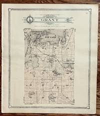
Map of Grant Township
by George A. Ogle
- Condition
- Used - Very good condition
- Published
- 1907
- Quantity available
- 1
- Seller
-
Franklin, Tennessee, USA
- Item price
-
A$177.26
Show details
Description:
Chicago: George A Ogle, 1907. Very good condition. Very nice Map of Gray Township.This map is from the standard Atlas of Lake County, Illinois by Geo. Ogle 1907. Very nice map in light gold color. In the upper portion is Fox Lake. Also shown are Pistakee Lake Nippersink Lake Long Lake, Duck Lake, Wooster Lake, Sullivans LakeFish Lake… Read more about this item Item price
A$177.26
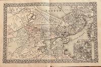
Plan of Boston
by Mitchell, S. Augustus
- Condition
- Used - Very good
- Edition
- 1879 edition
- Published
- 1879
- Binding
- 20 1/2 x 13 inches
- Quantity available
- 1
- Seller
-
Franklin, Tennessee, USA
- Item price
-
A$212.71
Show details
Description:
Philadelphia: Mitchell, S. Augustus, 1879. 1879 edition. 20 1/2 x 13 inches. Very good. This ia a double page map with an inset map of the immediate region. This lithograph was colored at the time of publication. Of importance is the display of the railroad network in place at the time of the printing of this map. The… Read more about this item Item price
A$212.71
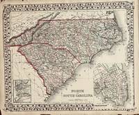
North and South Carolina
by Mitchell, S. Augustus
- Condition
- Used - Very good condition with paper re-enforced with archival mending tape.
- Edition
- 1874 edition
- Published
- 1874
- Binding
- 14 x 11 1/2 inches
- Quantity available
- 1
- Seller
-
Franklin, Tennessee, USA
- Item price
-
A$69.49
Show details
Description:
Philadelphia: Mitchell, S. A., 1874. 1874 edition. 14 x 11 1/2 inches. Very good condition with paper re-enforced with archival mending tape.. Mitchell, S. A.. Beautiful contemporary colored map of the Carolina states with an inset map of Charleston and a smaller scaled map of Charleston Harbor. Item price
A$69.49
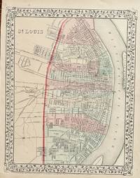
St. Louis
by Mitchell, S. Augustus
- Condition
- Used - Very good
- Edition
- 1867 edition
- Published
- 1867
- Binding
- 14 x 11 inches
- Quantity available
- 1
- Seller
-
Franklin, Tennessee, USA
- Item price
-
A$92.18
Show details
Description:
Philadelphia: Mitchell, S. Augustus, 1867. 1867 edition. 14 x 11 inches. Very good. Nice contemporary hand color graces this fine lithograph. The long levee abuts the Mississippi River with several railroads accessing the banks of the river. A very nice presentation. Item price
A$92.18
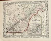
Map of Canada East and Counties
by Mitchell, S .Auguastus
- Condition
- Used - Very good condition
- Edition
- 1867 edition
- Published
- 1867
- Binding
- 13 1/4 x 10 3/4 inches
- Quantity available
- 1
- Seller
-
Franklin, Tennessee, USA
- Item price
-
A$85.09
Show details
Description:
Philadelphia: Mitchell, S. Augustus, 1867. 1867 edition. 13 1/4 x 10 3/4 inches. Very good condition. Contemporary color graces this lithograph done two years after the close of the Civil War. The territory includes the lower and middle St. Lawrence River with an inset map of Montreal. Item price
A$85.09
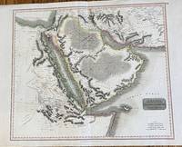
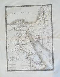
Arabia, Egypt, Abyssinia, Red Sea &c
by Thomson, John
- Condition
- Used - Good with very slight offset in the Indian Ocean and several repaired tears, mended with archival tape
- Published
- 1814
- Binding
- 23 1/4 x 19 3/4 inches
- Quantity available
- 1
- Seller
-
Franklin, Tennessee, USA
- Item price
-
A$709.05
Show details
Description:
Edinburgh: Thomson, John, 1814. 23 1/4 x 19 3/4 inches. Good with very slight offset in the Indian Ocean and several repaired tears, mended with archival tape. Menzies, J & G. Large double page engraving of the Arabian Peninsula and the surrounding area. From the Mediterranean Sea to the Indian Ocean, the detail is highlighted by contemporary outline… Read more about this item Item price
A$709.05
An Exact Map of the Provence of Quebec with part of New York & New Englan from the latest Surveys
by Russell, J.
- Condition
- Used - Very good
- Edition
- 1779
- Published
- 1779
- Binding
- 10 1/2 x 8 1/8 inches
- Quantity available
- 1
- Seller
-
Franklin, Tennessee, USA
- Item price
-
A$319.07
Show details
Description:
London: Russell, John, 1779. 1779. 10 1/2 x 8 1/8 inches. Very good. Lodge, J. Small scale map executed in great detail. From Montreal in the west to the St. Johns River in the East, the map covers in part or the whole of, Vermont, New Hampshire and New York. Portions of he Theatre of War in the… Read more about this item Item price
A$319.07
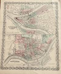
The Cities of Pittsburgh and Allegheny The City of CINCINNATI, OHIO
by Colton, G.W. & C.B.
- Condition
- Used - Very good with a couple of repaired tears using archival mending tape.
- Published
- 1855
- Binding
- 12 1/2 X 15 3/4 INCHES
- Quantity available
- 1
- Seller
-
Franklin, Tennessee, USA
- Item price
-
A$56.72
Show details
Description:
New York: Colton, J. H., 1855. 12 1/2 X 15 3/4 INCHES. Very good with a couple of repaired tears using archival mending tape.. This map page has two maps. The upper map is of Pitts burgh and Allegheny. It is accopnyied by the lower half map of Cincinnati. Most important is the connection between the two cities;… Read more about this item Item price
A$56.72
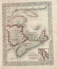
County Map of Nova Scotia, New Brunswick, Cape Breton and Pr. Edward Id
by Mitchell, Samuel Augustus
- Condition
- Used - Very good
- Edition
- 1867 edition
- Published
- 1867
- Binding
- 13 1/2 x 10 3/4 inches
- Quantity available
- 1
- Seller
-
Franklin, Tennessee, USA
- Item price
-
A$70.90
Show details
Description:
Philadelphia: Mitchell, S. Augustus, 1867. 1867 edition. 13 1/2 x 10 3/4 inches. Very good. Beautifully hand-colored map with the Gulf of St. Lawrence with associated provinces is shown. The provinces adjacent were colored when the map was made just two years after the end of the Civil War. Item price
A$70.90
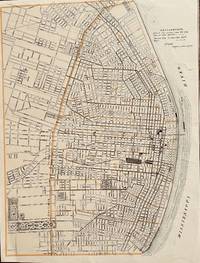
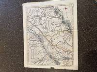
Explanations: Street Car Lines untitle map of St Louis
by Anonymous
- Condition
- Used - Good but a fragment of the U.S map and St Louis without title of other information.
- Binding
- 13 3/4 x 11 inches
- Quantity available
- 1
- Seller
-
Franklin, Tennessee, USA
- Item price
-
A$70.90
Show details
Description:
unknown. 13 3/4 x 11 inches. Good but a fragment of the U.S map and St Louis without title of other information.. This is a detailed map that is timed to the neat lines on both sides and untrimmed toplevy and bottom. The map focuses on transportation with the caption saying "Explanations: Street car lines run the way… Read more about this item Item price
A$70.90
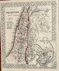
A New Map of Palestine and the Holy Land
by Mitchell, S. Augustus
- Condition
- Used - Very good condition
- Edition
- 1867 edition
- Published
- 1867
- Binding
- 14 x 11 34 inches
- Quantity available
- 1
- Seller
-
Franklin, Tennessee, USA
- Item price
-
A$120.54
Show details
Description:
Philadelphia: Mitchell S. Augustus, 1867. 1867 edition. 14 x 11 34 inches. Very good condition. Mitchell, S. Augustus. Contemporary color highlights this lithograph from two years after the closing of the Civil War. The map shows the Holy Land with an inset of the town of Modern Jerusalem. Item price
A$120.54

Plan of the Town and Fortifications of Gibraltar
by Tindal, Nicolas
- Condition
- Used - Very good condition except for a major tear going into the image expertly repaired with archival mending tape. No loss.
- Edition
- 1744 ca
- Published
- 1744
- Binding
- 22 3/4 x 14 1/2 inches
- Quantity available
- 1
- Seller
-
Franklin, Tennessee, USA
- Item price
-
A$354.52
Show details
Description:
London: Knapton, 1744. 1744 ca. 22 3/4 x 14 1/2 inches. Very good condition except for a major tear going into the image expertly repaired with archival mending tape. No loss.. Superb mid-eighteenth century engraving with full margins and strong impression. Tindall translated Paul de Rapin's thirteen volume history into English. Additionally, he wrote a continuation updating the… Read more about this item Item price
A$354.52
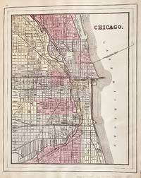
Chicago
by Mitchell, S. Augustus
- Condition
- Used - Very Good condition with several small tears repaired with archival mending tape
- Edition
- 1885 Edition
- Published
- 1885
- Binding
- Chicago, 10 3/4 x 13 1/2 : St. Louis, 10 3/4 x 14 1/2; Illinois, 14 x 20, with inset of Chicago and Vicinity of 8 1/2 x 6
- Quantity available
- 1
- Seller
-
Franklin, Tennessee, USA
- Item price
-
A$354.52
Show details
Description:
New York: Hilton & Hughes in Atlas of the World, 1885. 1885 Edition. Chicago, 10 3/4 x 13 1/2 : St. Louis, 10 3/4 x 14 1/2; Illinois, 14 x 20, with inset of Chicago and Vicinity of 8 1/2 x 6. Very Good condition with several small tears repaired with archival mending tape. This map was printed… Read more about this item Item price
A$354.52
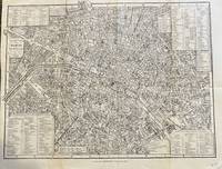
Conducteur dans Paris par Chas. Simonneau
by Simonneau, Chas
- Condition
- Used - Good condition with several tears repaired with archival mending tape.
- Published
- 1849
- Binding
- 12 3/4 x 10 inches
- Quantity available
- 1
- Seller
-
Franklin, Tennessee, USA
- Item price
-
A$134.72
Show details
Description:
Paris: Longuet, 1849. 12 3/4 x 10 inches. Good condition with several tears repaired with archival mending tape.. Chas Simonneau. A highly detailed engraved map with several inset locator panels design to make the user more efficient. The detail of the engraving is such that a magnifying glass is necessary. This ia a finely detailed small scaled map… Read more about this item Item price
A$134.72
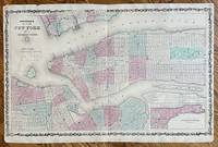
Johnson's Map of New York City and the Adjacent Cities
by Johnson, A. J.
- Condition
- Used - Fair condition with numerous repaired tears many going into the Mao Centerfold reinforced in areas with a tiny loss of engraved
- Published
- 1863
- Binding
- 25 3/4 x 16
- Quantity available
- 1
- Seller
-
Franklin, Tennessee, USA
- Item price
-
A$205.62
Show details
Description:
New York: A. J. Johnson, 1863. 25 3/4 x 16. Fair condition with numerous repaired tears many going into the Mao Centerfold reinforced in areas with a tiny loss of engraved surface from opening and closing the map. Faint water stain in the upper left quadrant. With all faults it would still look stunning matted, framed and hung on… Read more about this item Item price
A$205.62
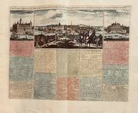
Carte de la Maison du Roy, des Etats des Conseils et du Gouvernment Civil, Ecclésiastique, et Militaire de Suede
by Chatelaine, Henri
- Condition
- Used - Very good +
- Published
- 1719
- Binding
- 17 1/2 x 13 1/2 inches
- Quantity available
- 1
- Seller
-
Franklin, Tennessee, USA
- Item price
-
A$425.43
Show details
Description:
Paris: Chatelaine, Henri, 1719. 17 1/2 x 13 1/2 inches. Very good +. Chatelaine. Hand colored engraved view of Stockholm. This mid-eighteenth century engraving was executed by a fine hand and presented the surrender panorama. Water surrounds the city in the foreground with windmills in the far distance. Period costumed individuals are artistically placed forefront. A very nice… Read more about this item Item price
A$425.43
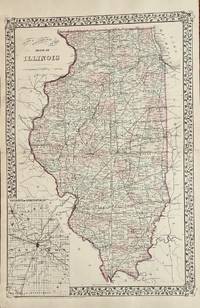
County and Township Map of the State of Illinois
by Mitchell, S. Augustus
- Condition
- Used - Very good with separations to the folds at the extremes repaired with archival mending tape.
- Edition
- 1879 edition
- Published
- 1879
- Binding
- 14 1/4 x 21 2=3/4 inches
- Quantity available
- 1
- Seller
-
Franklin, Tennessee, USA
- Item price
-
A$177.26
Show details
Description:
Philadelphia: Mitchell, S. Augustus, 1879. 1879 edition. 14 1/4 x 21 2=3/4 inches. Very good with separations to the folds at the extremes repaired with archival mending tape.. Mitchell, S. Augustus. Contemporary-color highlights this double page map. The State of Illinois covers 400+ miles from North to South. This map show all the counties along with the townships… Read more about this item Item price
A$177.26
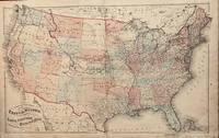
Railroad Map of the United States
by Lloyd, H. H.
- Condition
- Used - Good with archivally repaired tears and mild staining. Mild soiling lower right.
- Edition
- 1875 ca
- Published
- 1875
- Binding
- 24 1/2 x 15 3/4
- Quantity available
- 1
- Seller
-
Franklin, Tennessee, USA
- Item price
-
A$141.81
Show details
Description:
New York: H. H. Lloyd, 1875. 1875 ca. 24 1/2 x 15 3/4. Good with archivally repaired tears and mild staining. Mild soiling lower right.. Evert. This map shows the railroad network in the U.S. circa 1875. A worn lithograph with contemporary hand colored, the patina is indicative of age and a less than ideal life. However, the… Read more about this item Item price
A$141.81
Carte General de la Egypte
by Brue', A. H.
- Condition
- Used - Very good
- Published
- 1822
- Binding
- 14 1/4 x 20 inches
- Quantity available
- 1
- Seller
-
Franklin, Tennessee, USA
- Item price
-
A$134.72
Show details
Description:
Paris: A. H. Brue, 1822. 14 1/4 x 20 inches. Very good. A beautifully engraved map of the northern Nile area of Egypt. The Nile Delta region is filled with great detail. Hatchers are used to delineate the Valley of the Nile. A very nice presentation from Sidon in the north to Taphis in the south. Item price
A$134.72
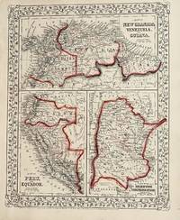
Map of New Granada, Venezuela and Guina
by Mitchell, S. Augustus
- Condition
- Used - Very Good
- Edition
- 1867 edition
- Published
- 1867
- Binding
- 13 1/2 x 10 3/4 inches
- Quantity available
- 1
- Seller
-
Franklin, Tennessee, USA
- Item price
-
A$70.90
Show details
Description:
Philadelphia: Mitchell, S. Augustus, 1867. 1867 edition. 13 1/2 x 10 3/4 inches. Very Good. Mitchell, S. Augustus. Contemporary colored lithograph map of Soth American countries. Suitable for framing. Item price
A$70.90
